I've almost been writing this blog now for almost two years, starting in January 2008. Many of my caching partners have come and gone, but there are a couple who have decided to hang around me for a greater part of my caching career. Chaosmanor has been hanging around me in geocaching the longest. In fact, we met through Where's George? before either of us got involved in Geocaching. 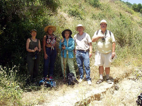 It should be noted that Chaosmanor is a husband and wife team, but I usually associate Jim with the Chaosmanor handle.
Through the years, we've been on numerous geocaching adventures together. Our first was on the western edge of Los Angeles County, where we hide a cache together near the spot where the television show The Lone Ranger, was filmed. Since that time, we usually went out caching with each other several times a year, usually when I had time off.
There, for awhile, Memorial Day weekend we usually got together to cache, and then we started meeting during my spring break. We are planning a trip down to San Diego over my spring break to find some caches as well as some virtual flags. In the past year or so, we just tend to get together when the moment strikes and both of us can get away for some caching fun.
It's really interesting to note that, although we do have different belief systems about a great many things, there are still many more things that we have in common. Many of our silly hobbies that we play, we share a common interest in, so we tend to get along very well. I enjoy his company and consider him one of my friends.
Yesterday was supposed to be a hiking day for us, but with the rain, we decided that we'd probably stay dryer by hitting some of the suburban caches around my neck of the woods. The best words to describe the two of us when we went out caching in the rain would have been, the odd couple. There I was, wearing a hooded jacket and long pants and he's walking around in shorts and not jacket. Later in the day, we ended up walking through a field, which was very damp. 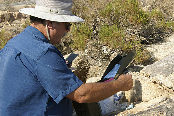 By the time we had walked out of the field, I was wishing that I had worn shorts, as the bottom three inches of my pants were soaked. But then again, with my hood, at least I could see, since my glasses were staying relatively dry. Each of us has our own idiosyncrasies, but in the end, it worked for us.
We both were working with our iTouches for the first time on a longer cache run, so we got to pick each other's brains (boy, that's loaded) for ideas on how to use this new app we'd downloaded for the iTouch. It worked well, because I think we both ended up learning some new things about the app which will help each of us as we continue to cache in 2010.
As always, I look forward to the next time I can cache with Chaosmanor. He's enjoyable company and we have a variety of different interests that always keeps the conversation running throughout the day. Happy New Year to everyone. May 2010 be better than the previous year.
Pictures were taken at the following geocaches:
SwitchBACK! - by WestwardHo
Mojave Green Travel Bug Motel - by The Dananator
Thursday, December 31, 2009
Cache Partners Redux

Sunday, December 27, 2009
Vasquez Rocks
Just after New Year's, I'm planning a caching trip with one of my caching buddies to Vasquez Rocks Park. It's located in the foothills of the high desert off of the 14 freeway. Basically, it's in between the Lancaster/Palmdale area and the San Fernando Valley. We were out there three weeks ago and had a great time, dodging muggles and finding a variety of caches.  It was there I ended up breaking my PDA near the first cache we found.
When we got there, the place was teeming with muggles and we weren't sure how many caches we were going to get. I think most people, myself included, have visions of grandeur when going out caching. We figure we have this many hours and we're going to get this many caches. Vasquez Rocks Park has 18 caches in it, so I figured we'd get them all. Well, with the muggles, we only got half as many.
Part of the problem was we spent an inordinate amount of time trying to find an access to one cache which was up on the rock formations. At least I think it's up on the formation. We never did get a good fix on it. After several attempts, we gave up on that one and headed over to another one which we found. It was there I discovered the PDA malfunction and I thought our day was really going to be cut short, but we improvised a way to access cache pages, so it was all good again.
Once we had that figured out, we had a new plan of action. One of our goals was a three digit cache, Between a Rock and a Hard Place. This cache had been placed there in April 2001. It was a large ammo can and was easily found. I always enjoy finding these old caches, since they're usually large ammo cans. I often wonder how they could have survived that long. The likely reason is most are placed well off the beaten track away from muggles. This one appeared to be near a well traveled trail which made its longevity that much more surprising. Needless to say, we enjoyed finding such a "old" cache.
After finding Between a Rock and a Hard Place, we worked our way downhill away from it, making an arc curving gently from the south over to the northwest and back to our starting position. This kept us away from most of the muggles in the park who were to the west of our location for most of our hike through the park.  We discovered early on, we had stumbled upon a large orienteering workshop/convention type of gathering. The organizers said the orienteering national championships were going to be held the next day at the park.
There were several times when we ended up crossing paths with the orienteering participants, which caused us some concern as we didn't want to compromise the cache hides. One cache hide was near where some judges were stationed, but we ended up being shielded nicely by the juniper bush the cache was hidden in. One other cache was within fifty feet of one of the orienteering stations, but no one appeared to be watching us at the time we made the cache grab and I've noticed that the cache in question has been found since we found it, so apparently, none of the orienteers accidentally discovered the cache. Or if they did, they decided to leave it alone, which also speaks highly of the organization.
At one point on our hike, we ended up on what looked like a fire road. Up in the foothills and mountains of Southern California, these are quite prevalent, so it wasn't surprising to have one here on the edge of the park. As we walked along the road, heading for one of the caches, we realized that we were walking along the Pacific Crest Trail. This was a nice bonus to the day, as in my mind at least, it's always fun to walk along a 2600 mile trail. You don't find too many trails that are longer than that.
Our last cache of the day was located at the north entrance to the park and it was an earthcache. We were treated to a variety of different geological formations within the park along a geology walk at that point. 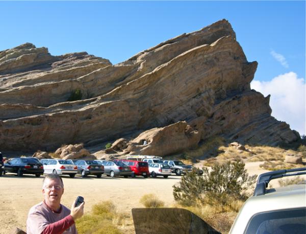 I took some pictures and we had to post a picture of us near the Vasquez Rocks identifying what kind of formation the Vasquez Rocks were. You can see from my picture the multitude of cars parked there for the orienteering gathering.
On the second we'll be back out there again, trying to get the other half of the caches we missed the last time. Hopefully, our visions of grandeur will be large enough that we'll end up getting all of the caches this time around. If not, I guess that gives us an opportunity to come back again in the future.
Pictures were taken at or near the following geocaches:
Vasquez Rocks Natura Area Park - by scott_n_roni
Vasquez Rocks Home (year:1850) - by fishingisfun
Vasquez Rocks Earthcache - by supertbone

Thursday, December 24, 2009
Christmas musings
Tomorrow, my family will be at our house to celebrate Christmas. I'm looking forward to seeing my sister who's been living either out of state (South Carolina) or out of the country (Hungary) for the past several years. She keeps saying that we need to visit her in Hungary. Yeah, with two kids in college right now, that's not financially possible, but maybe sometime in the future if she and her husband are still there.
 Today, I went caching for the first time since December 5th. As I've noted before, those two weeks of vacation is rather deceiving since the first week is all dealing with the prep work leading up to the "Big Day." Afterwards, there's lots of down time, time for caching. I've been caching for almost 9 years now and I have never been caching on any December 21st, 22nd, 23rd, 24th or 25th, until today.
I had everything on my "to do" list done and I decided that I needed a little walk, so I walked up the street for about a mile and found a cache just on the other side of the freeway from my house. I met a student of mine who's grandfather owned the strawberry patch on the corner near where the cache was hidden. We had a pleasant chat and then I continued on to find the cache. I passed several houses that were decorated in lights for the season. The one pictured has a TV situated alongside their driveway and they play the movie It's a Wonderful Life about three times a night. I watched it this afternoon in the comfort of my family room with my daughter and son. To each his own I guess. I think, if I get up early tomorrow morning before everyone else, I might try to find a cache tomorrow as well.
Merry Christmas everyone. Happy Birthday Dad.
Pictures were taken at or near the following geocache:
Trick or Treat - Smell my Foot - by Maddmaxxawr

Tuesday, December 22, 2009
Cruel Month
It is December again. As a school teacher, December promises some time off, to relax. After all there are two weeks at the end of the month that we have off. I could go geocaching a lot, it appears. Wrong.
I keep a spreadsheet of all things geocaching, just because I like playing around with numbers. I have been caching for almost 9 years now and I have never been caching on December 21st. And, if you want the full story, I have never been caching on the 22nd, the 23rd, the 24th or the 25th. Yet, I keep thinking to myself that I can get out during the week before Christmas and find some geocaches. Nope. It's not going to happen this year either more than likely. I've already lost the 21st this year and it's raining today, so the 22nd isn't looking good either right now.
I know some of your are thinking, "What, he doesn't like to cache in the rain?" Not really, plus I have other things that still need to get done before the family descends upon our house this year. And that's OK, I just need to remember next year and not even try to make plans, because they probably won't work anyway.
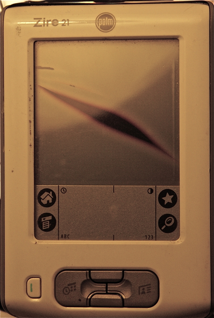
And the funny thing is, I've been itching to go out and cache since my last caching adventure on December 5th. At the first cache find of the day, my PDA bit the dust. You can see from the poor picture, that it's pretty much toast. I have no idea how that happened, although I can theorize about it. It doesn't really matter since it's beyond repair. Looking for a new PDA ended quickly. It's very difficult to find a stand alone PDA nowadays. Most are couple with cell phones. I don't need a new cell phone.
But, I found an interesting application for my iTouch that I think is going to work very well. Unfortunately, this cruel month hasn't allowed me to get out and really put the new app through its paces yet. It'll happen, just not this week.

Sunday, December 13, 2009
Soledad Canyon
Driving through Soledad Canyon last weekend was an enjoyable experience for a variety of reasons. The canyon runs basically eastward from the 14 freeway toward Acton, California. As one nears Acton, the road starts to bend towards the northeast and continues that direction until it connects back up with the 14 freeway as it makes its way north toward Palmdale and Lancaster. 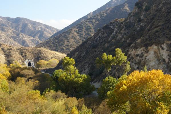 When we got to Acton, we turned north in town and went back up to the 14 by a different route since we were heading back home after our trip through Acton.
An active railroad right of way also runs parallel with the canyon road through the canyon. There were several caches along the road that had train themes to it, including a tunnel view cache. We heard and saw two trains go through the canyon while we were caching, but unfortunately, we were not in a good position to get decent pictures of either one. In fact, we missed a trail going through the tunnel view cache by a matter of five minutes. We kept hoping to see another train, and we eventually did, but the cache we happened to be near at the time didn't put us in a good position to train spot. Sometimes caching is like that and we accepted it.
The seasons in Southern California are relatively delayed as opposed to other areas of the country. We actually have two big blooming seasons, one in the springtime and one in the fall. Our fall colors (what we have of fall colors) usually happen in late November/early December lasting into the new year. It's finally getting cold enough at night that the trees are starting to drop their leaves in force. 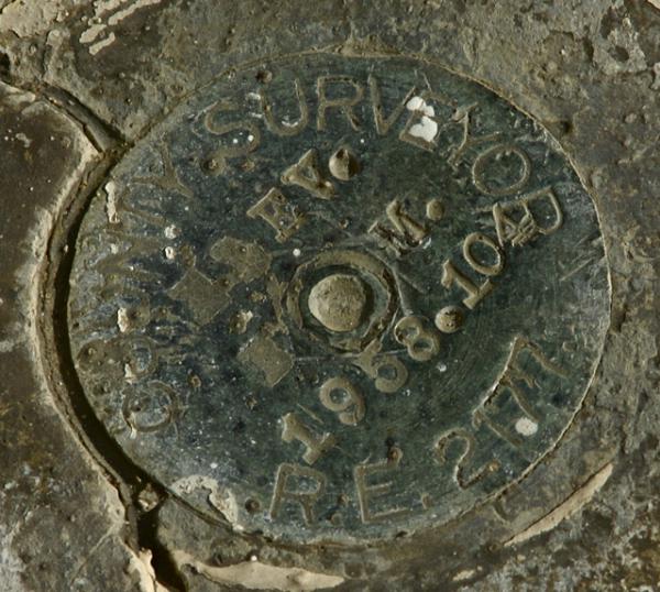 I have a silver maple tree in my back yard and while it doesn't have any leaves on it now, most of them were knocked off by several good winter rainstorms that came through this area over the past week. I would imagine the picture of the tunnel view would look something a little different this week with some of those trees being a lot more barren, leaf-wise, after this last series of storms.
The road we traveled on had several old bridges on it. We were in a canyon, so we crossed Soledad Creek several times and also crisscrossed the railroad tracks in certain areas as well. I kept looking for benchmarks along the way and I found a couple, but nothing that was in the geocaching benchmark system to log. With the railroad tracks in play in the canyon, we both suspected that the benchmarks were probably tied to the tracks in some way and after getting home and doing a little bit of investigating, it became obvious that many of the benchmarks in the canyon were indeed along the tracks and not along the roadway.
The bridges we did cross were old enough they were dated. I can remember growing up, the sidewalks had dates on them in several places. The company that poured the cement would put some free advertising into the sidewalk along with the date the sidewalk had been poured. I hadn't seen this type of dating in a long time, as the other areas I've lived in were newer neighborhoods and the practice seems to have been abandoned over time for some reason.  The neighborhood I live in now does have dated sidewalks however, since it's an older established neighborhood.
Bridges seem to have this same kind of dating system too. The company that built the bridge didn't put their name on the bridge, but at least a date could be seen on several of the one we crossed. One appeared to have been replaced as the bridge itself looked to be of a newer type of bridge, but the piers on which the bridge rests seemed to be the original pilings. Again, I found a benchmark near this one, but it was a small one and not listed in the system. The one that was listed in the system near this spot, was down on the railroad tracks. And so it goes sometimes when you're looking for benchmarks.
As I noted in one of my previous logs, the road was busy last week. There was an accident on the 14, so there were lots of cars using the canyon road as an alternate route to get around the backup on the freeway. Since we didn't get all of the caches in the canyon, we plan to go back in the future. Hopefully, the road will be a little more peaceful.
Pictures were taken at or near the following geocaches:
Train Tunnel View - by Yosemite John and Debbie
Thirties Train Tunnel - by Yosemite John and Debbie
Bridge to Shambala - by Yosemite John and Debbie

Friday, December 11, 2009
Seeing Red
One of the aspects that I so love about geocaching are the surprises that pop up from time to time along the way. 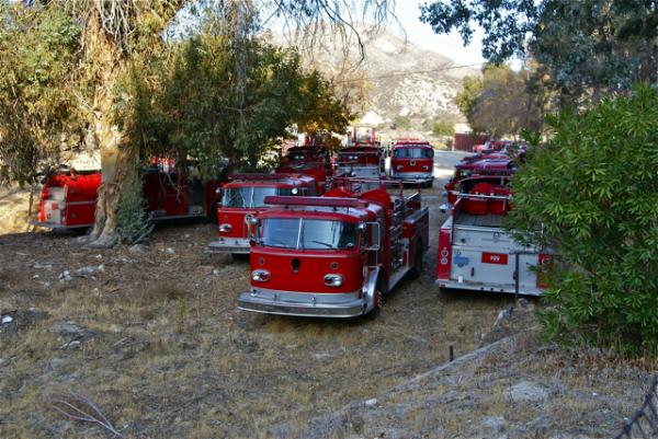 This past Saturday, I went caching at Vasquez Rocks Park (which I'll expand upon in another blog) and then into Soledad Canyon. Soledad Canyon would have been a quiet trip following railroad tracks that day except for the accident along the 14 freeway, which funneled a lot of extra traffic onto Soledad Canyon Road. So much for a little quiet, but otherwise, it was a good trip finding caches here and there.
One of the spots along the way was a small micro cache and it wasn't so much the cache that was a surprise as it was a fairly easy find. It's what was at the cache that made this one interesting. We'd stumbled upon a graveyard of fire trucks from different parts of Los Angeles County. My friend, 3blackcats, spotted a truck from the city of Pomona where she works in amongst all the other trucks that were parked there. It looked like the county just stores the trucks out there and gets parts as needed, although it seemed like a pretty out of the way place for most of Los Angeles County to store the parts for fire trucks.
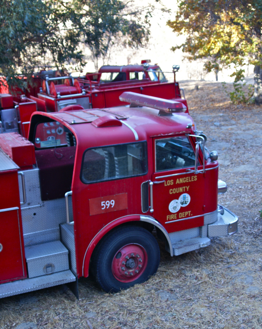 We parked near the entrance to the lot, then walked along the road back to the cache, taking pictures along the way. With all of the signs stating "NO TRESPASSING" there was no way we were going to go in and among the trucks. At the cache site, we'd just extracted the cache from the hiding spot, when a muggle came walking up the road toward us. This was a very large man who was obviously one of the caretakers of this lot and he was wondering what we were doing.
Caught red handed, we had to confess we were geocachers. He spotted the cache and said geocaching about the same time we said geocachers, so he knew about the hobby, saying one of his relatives participated in it. He was more concerned about us possibly trespassing because he said that there had been several other people who'd spotted the trucks and wanted to get a closer look, going over the fence, by the warning signs just to get a better look at the trucks. When we assured him we had no such desires he finally relaxed and became a little more congenial.
Since we were done, we walked back to our car together, chatted a little more and went on our way. Perhaps we've earned another convert to the hobby, since he seemed to be genuinely interested in what we were doing and we were fairly enthusiastic about it as well.
Pictures were taken at or near the following geocache:
Seeing Red? - by Yosemite John and Debbie

Sunday, December 6, 2009
Mushrooms
Hiking in the Redwoods is usually an enjoyable experience. Most of the time when Chaosmanor and I were hiking, I kept thinking about the Lord of the Rings books by J.R.R. Tolkien. 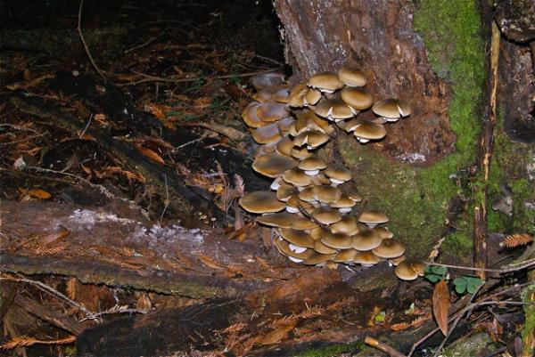 Hobbits like mushrooms and they will do just about anything to get a mushroom.
When we were hiking, there were signs announcing that it was mushroom season and apparently, there were lots of people who harvested them. I'm not an expert on mushrooms, so I'll partake of ones that I can purchase in my local grocery store. I can also remember my first college roommate harvesting mushrooms but for an entirely different purpose. We went to school at Humboldt State University and the area had lots of mushrooms, including several psychedelic "shrooms." To each his own, but at that time I didn't understand the attraction of mind altering substances, nor do I really understand the need to partake of any today.
I prefer to look at plants for their intrinsic beauty. Yes, I believe even mushrooms have an aesthetic value to them. These were just some of the ones we saw along the trail while on our hike north of Santa Cruz. Interestingly, although there were signs announcing mushroom season, we saw very little evidence that the locals were harvesting the mushrooms. 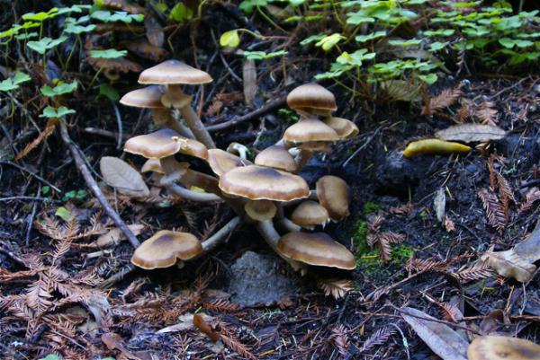 I was also somewhat surprised at the amount of mushrooms that were growing out of the bark of some of the trees.
Yes, I know they are part of the decomposition needed in the forest and although they usually don't work very well on Redwoods per sé, since redwood trees have so much tannin in them that they decompose at a very slow rate. The fungi does help improve the soil by helping decompose other plants that have died. The one picture I really enjoyed was the one that included the banana slug. I hadn't even noticed the slug until after I got home and downloaded the picture on to my computer. As a size perspective, I figure that banana slug was about 6 inches in length.
I'm not sure where this one is going. I actually just wanted to share some of the pics from that hike and figured this would make a decent subject. Please enjoy.
Pictures were taken at or near the following geocaches:
Rising Stump Cache - by Chickasaw of ynots4
Down By The (Fall) Creek - by iwikepie and company

Wednesday, December 2, 2009
Monarch's Rest
 In addition to rectifying an old DNF, chaosmanor and I found several very interesting caches. One of the ones that will stick out in my mind will be Monarch's Rest. When we were planning our route, we were basing the route around getting some of the virtual flags that both of us like to collect at GeoVexilla.
Because we were headed towards Cambria, along California's central coast, we would be traveling along either the 101 or Hwy 1 depending upon where we were going to be in any particular segment. We'd been traveling along the 101 for awhile and were headed over to Pismo State Beach which fronts along Hwy 1, sort of where the two roads join up. Pismo State Beach is one of the major wintering grounds for the Monarch butterflies. What better spot for the Monarch's to rest than along the El Camino Real, The King's Highway.
There's a virtual cache at the spot that you're only supposed to be able to log during the winter months because that's when the Monarchs are there. 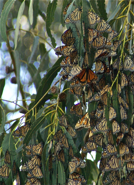 When I was planning this route, I happened to see this cache on the map and thought it would be interesting to visit. It was also wintering season, so there was the bonus of getting one of those yellow smileys that we geocachers love to get.
When we got there, there was an interpretive session going on by one of the docents, but we chose to wander the paths, to discover the Monarchs all by ourselves. Immediately, we spotted one sitting by itself on a eucalyptus tree. As we walked, I could see one flying through the trees, but we weren't seeing a large clusters that I'd heard about so I was a little disappointed. I'd seen a Monarch once in Kings Canyon National Park, but I was hoping to see some of the wintering behavior.
As we hiked along the backside trail, we didn't see anything other butterflies, so we decided to go back up and walk along the main trail. Both of us enjoyed the solitude of the lower trail as there weren't any other people along that trail. And for good reason because we realized our error as soon as we got up to the main trail where the multitudes of other people were. Hundreds upon hundreds of butterflies were clustered in the eucalyptus trees.
I think what was really impressive about the display was not the butterflies, but the quietness of the people in the grove. It was almost like they were entering a shrine or church of some kind. Even small children, upon seeing the butterflies, opened their mouths in wonder, but there wasn't a lot of the screaming and inconsiderate behavior that we commonly find in other areas where it really should be quieter. It was refreshing to see and hear.
Geocaching continues to bring me to these kinds of places, places that I either didn't know about, or were possibly off the beaten track where I would normally go. 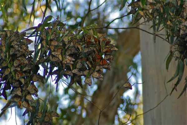 I very rarely get to travel in the fall or winter due to my work, but because my school was off the entire week of Thanksgiving, I had the opportunity to discover this area. I'm glad that I saw this particular cache on one of the geocaching maps.
Pictures were taken at or near the following geocache:
Monarch's Rest - by Jon & Miki (Adopted by Scooterman)

Friday, November 27, 2009
Rectifying a DNF
In the past, I've written about some of my Did Not Finds (DNFs). Many, I've never found and that's all right, while others, I've gone back and finally found. This week, I was able to scratch another one off of my DNF list.
 Late last week, I suggested to my friend Chaosmanor that we might be able to take a short road trip up to Santa Cruz for some caching. My son, who's attending school in Santa Cruz, was getting ready to start his Thanksgiving break and I figured it would be enjoyable to have someone else along for the ride up to pick him up. We finalized plans and I took off early Tuesday morning to pick up Chaosmanor who lives in Ventura County to the west of me.
Once on the road, we ended up caching up until darkness set in, then we took a more direct route to Santa Cruz. The following morning, we'd planned a hike in Fall Creek Park, just north of Felton, which is about 10 miles north of Santa Cruz. One of the caches in that park is IXL, a mystery cache that I've attempted to find twice in the past. It's not like I've been actively trying to get this cache, but both times we've camped in the area, we've tried for the cache and not succeeded. This time, hopefully, would be different.
As we started down the trail, Chaosmanor got the necessary numbers from the signs that would get us to the next waypoint.  I already knew where we needed to go to find this cache, but he wanted to go through the process of the mystery, which was fine with me. On the way, we stopped and found a very nice letterbox hybrid cache and another smaller cache hidden in a redwood stump. Then, like it was 7 years ago, we were near the spot where IXL was hidden.
As Chaosmanor inputted the correct coordinates into his GPSr and told me what they were, he said, "Wow, you were really close last time." Yep, that's what was frustrating about it. In my defense, I had a grand total of 77 finds by the end of 2003, so I wasn't what you might consider an experienced cacher, although I had been caching for the better part of three years. I was more of a casual cacher, getting a couple per month, or maybe one on a weekend. Now, the "geosenses" started tingling. I suggested, based upon the hint, which had been there in 2002, that we try over there, a spot we had never tried on my two previous forays for this cache.
We ended up over what was now looking promising for ground zero for the cache and started looking. I struck out where I was looking and Chaosmanor struck out where he was looking, so we switched spots. At this point, we'd both passed about 3 feet from the cache. I tried where he'd been looking, then tried another spot farther up the hill.  Striking out there, I turned around to make my way back down the slope when I realized what I'd been missing all this time. I was looking at the hint on the cache page. I was up too high.
Keeping the hint in mind, I worked my way back down the slope and just about when I got to the bottom of the slope, I spotted the hiding space, no more than about three feet behind Chaosmanor. He'd been searching the same place I had. We both had had our backs to the cache hiding spot. It was plain as day, yet it blended in with the surroundings naturally, that experienced cachers, might miss it, which we had for awhile.
As I posted in my log for IXL
Price of a newer GPSr - $200
Extra supply of batteries, just in case - $5
Rectifying a 7 year old DNF - Priceless
Pictures were taken at or near the following geocache:
IXL - by Diana, Jim & Bryan

Sunday, November 22, 2009
Walk of Honor
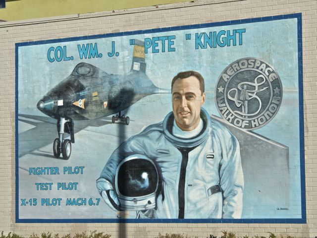
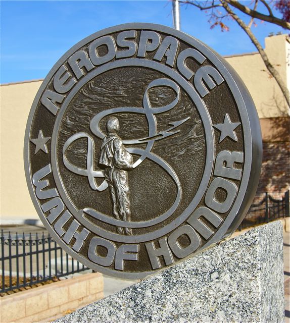 The Tadpole and I headed up into the high desert again yesterday. It was the first day of a 9 day vacation for me, and I wanted to get the last couple of quads in the desert that had still eluded me for the Los Angeles County Quadrangle Challenge cache. We also stopped and found a very nice virtual in the city of Lancaster. Although, this one wasn't in any quadrangle that I needed, it was a stop well spent.
I'd been here three years ago in the exact same spot with some other caching friends of mine. It was August and I remember it being hot, but that didn't stop us from enjoying the day. We solved a mystery cache involving the Lancaster Public Library and found that cache. One of the stops on the virtual we found yesterday is right outside the library entrance. I'm at a loss as to why we didn't do this virtual back then, but for some strange reason, we didn't.
In actuality, that worked out for the good, since I was able to take my astronomy loving son up here where he could learn about some of the pioneers in the aviation industry as well as the early pioneers of NASA, probably before it was even called NASA. Monuments to different pioneers line Lancaster Blvd. on both sides of the street, with information about various people who were instrumental in the testing of different aircraft. Neil Armstrong was highlighted, as was Fred Haise one of the astronauts on Apollo 13. Chuck Yeager and Jimmy Doolittle were both highlighted with monuments and murals on the sides of buildings along the street.
 As we gathered the information needed to qualify for the find of the virtual cache, there was one monument that stood out. This particular pilot shared our last name. I pointed it out to the Tadpole and we both got a "Wow, that's cool" moment. I wondered whether we could have been possibly related to the man, but most of my relatives came from the northern Indiana and Ohio area. We were the first in my dad's family to move west.
The cache needed 7 specific bits of information. After we'd walked the entire route, on both sides of the street, we realized that we missed the first bit of information. Based upon where we'd found the other bits of information, we figured where that information should have been, so we walked back down there to check out the monuments again.
I told the Tadpole that we needed to be systematic on our approach to this one, so we started on one side and read through each monument. It didn't take long to get the correct information this time. We found it on the pilot who had the same last name as us. We'd been both so interested in thinking about that aspect of the pilot, that we hadn't looked close enough at the rest of the information on the monument. Needless to say, we got a good laugh out of that.
There was a bonus in all of this as well. Because of our trip to get that last bit of information, we took a slightly different route to get back to the car. At the base of a building near the entrance of an alley, we found a very nice looking benchmark. We'd walked by it one other time, but for some reason, I spotted it this time. That was a nice addition to an already enjoyable day with my son.
Pictures were taken at or near the following geocaches:
Aerospace Walk of Honor - by DoeWalking
 Book Worm - by Team Perks

Wednesday, November 18, 2009
Desert(ed) Buildings
When you cache out in the desert, you sometimes come across remnants of things that used to be. In our case last week, we came across lots of different remnants. We came upon buildings that were barely there, somewhat there and almost all the way there.  Chaosmanor hid a cache last week called, For the Birds? There was some interesting foundations at the cache site that had us speculating what had been there.
There were foundations of several buildings on the site, which was just off the road. I could make out a fence, with at least two gates. The main foundation of some type of homestead was still visible, and what looked like a garage of some kind, perhaps a barn just on the other side of the fence from where the main house was. It was fun to think about living out here in the desert and trying to survive. We found what looked like a well, and also a bird bath perhaps, which is what inspired Chaosmanor to name his cache.
In another spot, we came across an old socialist camp started in the early part of the 20th century. The camp lasted but 3 years or so before being abandoned because of water shortages. Apparently, the founders had miscalculated the amount of water they would be able to get from a nearby stream and thus ran out of water. Amazingly, in the short time the colony was flourishing they managed to build several large buildings. 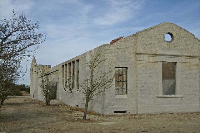 Many of the buildings were dismantled and the materials were used elsewhere in this part of the desert, but enough of some of the buildings remain so that you can get a sense of what it might have been like out in the desert nearly 100 years ago.
At another cache site we found a large abandoned building. We found the cache very quickly, but we stayed a lot longer taking in the building. The owner of the cache speculated that it appeared to be a Grange Hall, but he couldn't find information to confirm that. I speculated that it might have been an old church of some kind. It gave me the impression that that's what it could be, but another finder a couple of days after us found an old Topo map which indeed showed it to be a Grange Hall for the area.
Spots like this are what bring me back to the desert. Looking at the satellite photos gives you some kind of impression of an area, but when you actually get to at site, you really get a feel for what went on there. The history of an area can sometimes be told by the stuff that gets left behind.
Pictures were taken at or near the following geocaches:
The Llano Del Rio Geocache - by Kit Fox
Mystery Building - by Obtuse

Sunday, November 15, 2009
Banged Up, Battered, & Bruised
I went out caching with Chaosmanor and the Tadpole on Saturday. We didn't find nearly as many caches as we did on Veteran's Day, but it's not about the numbers, 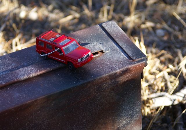 but about the quality of caches and the companionship that comes along with any caching trip with friends.
I found another neat spot to hide another cache. I called it Banged Up, Battered, and Bruised mainly because of the cache container, an ammo can that I found at my nearby surplus store. It had several dents, was heavily rusted on the inside of the cache and just looked pretty much used up as a decent ammo can. Now as a cache container, almost anyone can do miracles with a couple of cans of spray paint.
I found a red jeep in another cache earlier in the day, so I decided to drop that into the cache as well. It's just a short walk from the parking spot to the cache, but it was in a nice spot. I hope it ends up lasting a long time out there. Now I need to start working on my 30th, which I'm pretty sure will be a puzzle cache, with a hike.
Picture was taken near:
Banged Up, Battered, and Bruised - by Webfoot

Wednesday, November 11, 2009
Dead Prophet
I went caching today with my good friend Chaosmanor out in the high desert north of my house. We had a good day caching, spending many hours finding caches in several different quadrangles in pursuit of the Los Angeles County Quadrangle Challenge.  I'm not sure yet, as I haven't taken a real close look, but I think I was able to knock off 11 more quads towards the ultimate goal of that challenge.
I also hid another cache today, Dead Prophet. It's a short hike into the desert to the base of a dead Joshua Tree to find a cammoed decon container. I thought I'd found, a better spot for it about 200 feet south of where I ended up putting it. While looking around that particular Joshua Tree, I noticed a large raptor's nest up in the crown of the plant. I figured that it would be better to not disturb the nest, so the cache went where it is. Maybe cachers will get lucky and see the raptor's when they're actually using the nest during mating season.

Friday, November 6, 2009
Cache Partners
I haven't been caching as much lately. Work has kept me busy, and with the Tadpole now in high school and running cross country there have been fewer opportunities to go out on a regular basis.  I had an opportunity to get some caching in this afternoon, since it's a Friday and I was without students today. Teacher inservices tend to allow you out a little bit earlier than usual. I didn't, mainly because I enjoy caching with other people a lot more than caching alone.
Tomorrow, the Tadpole and I will be doing some local caching. It's the first time he and I have been out caching together since summer vacation I think. It will be nice to get out and enjoy the outdoors a little with one of my caching partners.
My first caching partner was my other son. When we first discovered caching, he was 10 years old. He's now away at UC Santa Cruz enjoying his first year of college. I have to assume he's enjoying it, since we've not heard much from him.  I rather would like to think that no news is good news, because he's the kind of kid who would be letting us know if things weren't going so well.
When we started geocaching, back in 2001, caches were hidden along trails away from civilization. Hikes of 2 miles or more for one cache were common at the time. I believe that's what appealed to him. When we'd go camping, he was always the first one who suggested going on a hike somewhere. Geocaching was a way to get us out on the trail around here. We hiked in Chino Hills State Park and up into a canyon behind Jet Propulsion Laboratory (JPL) in Pasadena. We climbed to the top of a smallish hill in San Dimas to find a cache as well as in Schabarum Regional Park to the southwest of our house.
He enjoyed trading things at the caches. Squirt guns, slime, whoopie cushions and anything else that you can imagine a boy would like,  he'd want to take, so I made sure that I always had trade items with me that we could replace these treasures that we'd find in the cache.
Somewhere down the road, however, he grew up and put away those childish things. His last camping trip was after his 7th grade year. At the end of his 8th grade year, he decided that he wanted to go out for the cross country team in high school. They practiced all summer and although the coach made allowances for family vacations, my son didn't want to miss any practice. Running became his focus and so camping and geocaching were pushed to the wayside.
In fact, his thoughts on geocaching are, "that dorky thing that Dad does." Perhaps in the the future, he'll change his mind about camping and caching. Perhaps not, but I'll leave the door open anyway. My daughter has expressed and interest in going camping with us again, so it's always possible he will too. That would be nice. This particular blog entry is dedicated to my middle son.
Pictures were taken at the following geocaches:
Old Mossy Cache - by OtisPug
THE LOST AMADEUS - by Lizard
ONT Travel Bug Ground Central - by Crims0ngh0st & AcjLady

Monday, November 2, 2009
Capture the Flag again
This weekend was a very enjoyable weekend. My first trimester of school ended and because I had all my grades already done, all I had to do was bubble in the grades on our computerized form and turn them in this morning.  Needless to say, the weekend was mine to be had.
Saturday morning, early was devoted to rounding up all of the electronic equipment that either didn't work any more, or had outlived their usefulness in our household. My wife's school was having a free e-Waste disposal that day, so it made for an easy and cheap way to get rid of a couple of excess monitors and other electronic stuff that had been sitting around the house for awhile. After that, I decided to go out and find some virtual flags.
Some of you know that GeoVexilla is a virtual flag game that places random international flags virtually around the globe. Each time you get within a 100 meters of a flag you score points for that flag. When you find a flag, you generate a new set of five flags. The first flag is worth 1 point, the second 2, the third 4, the fourth flag is worth 8 and the fifth and final flag is worth 16 points.  Eventually, the flags disappear off the map and are replaced randomly by other flags. This particular weekend was a bonanza weekend for virtual flags near me as I was able to find six flags, worth anywhere from 1 to 16 points.
Two of the more interesting spots I found flags was on the top of a mini-mall in Long Beach. The flag of Belize was perched on top of the roof of a Bristol Farms store. I couldn't quite zero out on that flag, but was able to easily get within 100 meters, so I scored the one point. That was the first time I've found a Belize flag, so it generated a set of flags for me. Because of other flags that I've found in the past, I was able to move flags around and actually fill out the entire set that this particular flag generated, which gave me 31 points for a full set. Of course, since I moved flags around, that created gaps in other sets, but I'll eventually fill those in as time goes on.
Another flag that I found this weekend was a Columbian flag which was flying high on a ridge overlooking an avocado farm near Temecula, CA. I was able to take roads through an organic avocado farm, then walk up a short paved trail/road to get within scoring distance for this flag.  The views from the top of the ridge were fabulous. From the looks of it, that particular spot looked to be very popular with the younger set, because of the debris of broken glass bottles that were rather prevalent on the road near the top. At night, I'm sure the view would be even prettier with the twinkling lights of the city below in the valley.
That's one of the nice things that I enjoy about this GPS game. Because the flags are randomly generated, there's some unknown quality built in to finding the flags. It's not like geocaching where you know someone has been there. With this game, it may not be possible to access a point, because of private property laws, or other restrictions. Sometimes they end up being placed by the game's computer in the middle of a wilderness area with no accessibility. Just in the last day, a new Bahamian flag has shown up in the Long Beach harbor. It looks like the only way to score this one would be to take a boat into the harbor and sail over to the point. It's the randomness that makes this game fun.
Pictures were taken at or near the following virtual flags:
VX39-UDOD
VX39-UVAS

Sunday, October 25, 2009
Tanks
Yesterday, the Tadpole had a cross country meet at the Mt. Sac Invitational Cross Country meet, one of the premier running events in the country. I decided that I could cache in the area with my friend 3blackcats and then head over to Mt. Sac to watch him run. Unfortunately, he woke up not feeling well and so didn't run, so most of my day was spent caching.
We found a number of interesting caches in the area and had a pretty strenuous hike right after lunch. We were trying to find one cache, but couldn't find a way in, so headed to the next cache and missed a small cutoff trail that would have led us right to the cache. We didn't realize that was happening until we'd gotten all the way to the top of the hill. The trail kept switchbacking on us, taking us tantalizingly close, them drawing us away so we thought we were on the right track. It wasn't until we got almost to the top that we realized that we were finally walking away from the cache.
A quick check of the GPSr showed that we were 21 feet away from another cache which we found. We were also very close to a couple of water tanks, which I took pictures of figuring I could waymark the water tanks in the water towers and tanks category. There was another cache just beyond the tanks, so we ended up going over to that one as well. There were some nice house up on that ridge with views of two different valleys. Talk about multi-million dollar views.
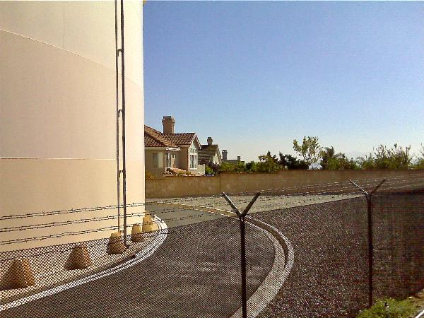
On the way down, we ended up finding a way into the original cache we'd started out to find. So, in retrospect, it wasn't a bad idea to go after that one cache. We ended up getting two extra bonus caches because we couldn't get to the first cache right away, plus I was able to waymark those two water towers. It was a pretty good day.
Pictures were taken at or near the following geocaches:
El Gordo - by UNCLEJON91
You Can Start Here - by UNCLEJON91
