I stumbled upon a new website, or at least new for me, so I've been playing around with if for a little bit the past couple of days. Yesterday when I woke up, it was overcast, a little unusual for this late in July in Southern California, so I thought I'd take advantage of it and hike up to a benchmark that I can see anytime I do go hiking in my local area, yet have never logged because it's "up there" on top of that hill. I decided that I'd take advantage of this new website, Every Trail that I'd been looking at while I was on the hike. I learned about Every Trail from a friend's blog a couple of days ago.
Johnson's Pasture - Claremont, CA - Widget powered by EveryTrail: GPS Geotagging
With Every Trail, you can upload your GPSr tracks to the website and create a trip, complete with maps and slideshow. This is the first time I've attempted this. I was having a little bit of trouble uploading the track log directly from the GPSr to Every Trail, so I opened up MapSource the software that came with my Garmin and created a track log with that. Every Trail took that file and created my first track on the site.
Then, I created the trip and started adding the pictures to the trip. I learned a couple of things with this first trip. When I started the GPSr, it was at the top of the hill at the benchmark. I think I'd start at the parking area and end it up there if I were to do it again. The second thing I did was uploaded the pictures out of sequence. Some of the shots are guesstimates as to their placement, but they're pretty close to where I took them. By zooming in, I can see where  I backtracked to take the picture of the poison oak at the base of the Eucalyptus tree. If I were to do multiple tracks, like on this camping trip we're going on next week, I'll probably want to mark where I took each picture. That will help in placement later on. Overall, though, I don't think it's too bad of a first effort.
You can see a larger version of the hike here. Above the map, there's a stats link to check out the elevation changes of the hike. You can also view the map in full mode if you'd like as well. If you zoom in on the map, you'll see where I started and stopped along the hike, most likely to look at things like the deer that bounded across the trail right in front of me. The side spur about midway along the trail is when I went to check on a cache of mine that's hidden there. I think I'll try this again on one of the hikes that I take with my son on our camping trip.
Pictures were taken at or near Pasture-ized - by catrunr
Tuesday, July 29, 2008
Every Trail

Sunday, July 27, 2008
New cache
I received three DNFs on one of my caches, so I figured I'd better go out and check it out. Apparently, the local gardeners had gone a little crazy with the pruning and did a number on that particular cache.  That's not the first time, so I figured it was time to archive it and place a new one out there. So now I am the owner of The Case of the Strangled Sycamore.
I had a container at home that I wanted to use for this one, so when I went out there to check on the missing one, I picked up some local material to use as camouflage. With my standard spray paints and camoed the container and then applied the finishing camo. I'd heard about Gorilla Glue in the past, but never had used it before this weekend. I'm a believer. It's some interesting material. Most glues, you apply to a dry surface, but this one you apply to a damp surface. I suspect that there is some kind of chemical reaction that happens with the water and the glue, because not only does it adhere well, it also expands to fill in those nooks and crannies that you might have missed, leaving for a nice bond between surface and material that your're gluing to the surface.
I got two nice logs already for the finds on the cache talking about the nice camo, so I guess I did ok with it. I still have this other ammo can out in the garage and I think I'm going to work out a letterbox hybrid for that one.
Pictures were taken near The Case of the Strangled Sycamore - by Webfoot

Friday, July 25, 2008
Turbocharging Cachemate
I got myself a Palm Tungsten T5 a while back to use for paperless caching. Now, before I scare away those of you with limited budgets, I'll confess that it's much more than I really need for the task -- in fact, my old Palm IIIxe, which I sold to another cacher for about $20, would have been more than adequate for the task. But the color screen is a lot easier for me to read (most of the time -- glare can be a problem on sunny days), and the additional memory along with the support for an SD memory card were big plusses for me.
You see, there are some days when I set out specifically to go caching. So creating a pocket query, getting the data into Cachemate, and hitting the road aren't big problems. BUT . . . . there are even more days -- say, about 90% of all days -- when I'm simply out and about in the Chicago metro area and find myself with some time on my hands and wishing I could find a cache or two nearby. But if I didn't know ahead of time I was going to be in that area, and that I'd have time for caching, then no PQ, no Cachemate data, and no waypoints in my GPSr.
So, I've set up a series of pocket queries that run weekly to collect all of the caches in areas of interest to me -- Northern Illinois (roughly, everything north of I-80), parts of Wisconsin (where I camp, and where my daughter goes to college, and the routes along the way), parts of New Jersey (where my in-laws live <insert your own New Jersey and/or in-laws joke here.>). Right now, in GSAK I have 5365 Illinois caches, 1366 Wisconsin caches, 998 New Jersey caches, and 127 caches in a database I call "events" -- not geocaching events per se, but any special occasion for which I want to load up caches in particular areas.
Uh-oh.
Turns out it's easier said than done. When I hotsync my PDA and start to load up the data into Cachemate -- especially the large Illinois and Wisconsin data loads -- I can watch everything progress nicely for the first couple hundred caches. But then it gets slower . . . . and slower . . . . . . . and slower . . . . . . . . . . . . . and slower . . . . well, you get the picture. And, sometimes, the load fails before it's processed all the caches.
There has to be a better and faster way. Fortunately, there is! Cachemate supports memory cards on the Palm PDAs, and in the documentation it describes how to take advantage of it. But before going into the technical details of how to do it, let me give you a quick description of why it works.
When you create your Cachemate file for the PDA and hotsync it, what happens is that Cachemate loads (or tries to load) all of the cache data into its database. If you have thousands of caches, many of which may have lengthy descriptions and/or lots of logs, that takes up a lot of space and time. When you use memory card support, though, Cachemate handles the load a bit differently. Instead of copying all of the cache data to its database, it instead loads just the cache ID and a few bits of other data, along with a pointer to the rest of the data which remains on the memory card instead of being transferred into the database. In addition, since you're going to take the hotsync process out of the procedure, you can save even more time getting the data to the PDA. So, let's move on to the geek stuff.
Step 1: Clear databases on Cachemate (optional, but recommended) For me, GSAK is my database of record. While Cachemate can merge information, I always completely replace the data with new data from GSAK. On your PDA, launch Cachemate, then from the menu, select each of your databases you are about to load, and use the CLR button to clear them out.
![]()
Step 2: Connect your PDA to your computer as a USB drive. Plug your Hotsync cable into your PDA and a USB port on your computer. (USB 2.0 is recommended, if available -- it's a lot faster.) Go to the main application screen on your PDA; there will be an application called Drive Mode. Tap on that application, then tap on the Turn Drive Mode On button.

Step 3: Create folder for Cachemate files (first time only) Your PDA will now show up in Windows Explorer as a disk drive -- or two, if you have an SD card installed. (**See important note at the end of this article.) On this new disk drive, you have to create one of the four folders that Cachemate looks for, as described in the documentation. To keep it simple, I created the \Cachemate folder. You only have to do this the first time.

Step 4: Create Cachemate files. I use GSAK, so that's what I'm using in this example. But whatever tool you use to create your Cachemate files, the process should be similar. In GSAK, you simply specify the drive letter and path for the file you're creating, pointing it to the folder you just created. Also, uncheck the box that says Install to Palm after conversion -- you don't want to do this, because there is no need for Hotsync to process the file. After you've created your files, they'll show up as .pdb files in the folder you created.

Step 5: Disconnect the PDA from the computer. And make sure you do it properly, so you don't lose any data. Down in the system area of your Windows taskbar is an icon that will allow you to "safely" disconnect your USB drive. You need to do this so that Windows will flush out its write buffers to your PDA. After Windows tells you it's safe to remove the device, then click the Turn Drive Mode Off button on your PDA.

Step 6: Launch Cachemate and load data. Launch Cachemate on your PDA. A screen will pop up telling you that new files have been found on your memory card. Click OK, and then a file import dialog will appear, once for each file you created. For each file, select the Cachemate DB you want that file imported into. If you didn't clear the DB first, then Cachemate will merge the data according to whatever identifier you selected for cachemate -- name or waypoint code.

Step 7: GO CACHING!!
How fast is it? Well, for the 5000+ Illinois caches I load, the import used to take 10-15 minutes -- if it worked at all. It often failed to complete successfully. With this new procedure, the import process on Cachemate finishes in about 30 seconds, and it always works. Do I need any more reasons to use the memory card support?
Update@21:05 -- let me clarify that this does not depend on having a separate memory card. If you can put the device in Drive Mode, then you can write to either the internal memory or the removable SD card. So if you have an older PDA that doesn't support an SD card, this may still work for you. And if your PDA does not come with a Drive Mode application, there may be a freeware version available you can download and install.
(**OK, here's the important note I promised you earlier. If you have an SD card in your PDA as well as its internal memory, it will show up as TWO separate drives when you turn on Drive Mode. And here's the kicker -- it always wants to use the lowest available drive letter plus the next consecutive drive letter. If that next consecutive drive letter is in use, it won't map the SD card. So if you have the most basic configuration with your hard drive as C: and a CD or DVD as D:, when you enter Drive Mode on your PDA, it will use drive letter E: for the internal memory, and F: for the SD card. But let's say you already have a flash drive attached as F: -- then, Drive Mode will map the internal memory as E:, but won't map the SD card at all. I tore out more than a little bit of hair before I found someone's blog post documenting this.)

Wednesday, July 23, 2008
Hidden messages?
I'm beginning to think someone is trying to tell me something. There was a time when I didn't purposely go out to find micros. I had a couple of reasons for this. One, micros represented something that I felt took geocaching in the wrong direction. Two, I have no patience when I'm looking for something that had been hidden so evilly that I get the feeling that the hider doesn't want me to find it in the first place.
When it became apparent that micros were here to stay, I started looking for them, mainly because if I didn't, I probably wouldn't go caching very often due to lack of nice hiking trails in my general area. So I compromised. There were times when I found a few, and there were times when I found a lot and there were times when I didn't find any. Today, I fell into the last category.
Let me describe my day. I went out to get some socks, gas up the car and get the car washed. Where I was headed was an area near my work that I'd avoided caching in for awhile, so there was a buildup of new caches in that area. I figured as long as I was out there, I could pick up a couple of caches. My first stop was a gas station, where the placement of the cache was such that unless you could grab the parking spot next to where it was hidden, you'd look pretty out of place. The place was packed, there were muggles everywhere and as I've noted before, I don't have a lot of patience, so after about five minutes of trying to look nonchalant, I decided that I needed to move on.
The next cache, I could see. The problem was, it was hidden only five feet away from a restaurant/bar that was open. I couldn't see in, but I knew people could see out. The other problem with this cache was it was hidden two feet over my head. I'm not the tallest person in the world, but unless I come with a friend that I can boost up, or bring a stool, that one's not going to be found. The establishment being open didn't help me either. I've contemplated getting one of those grabbers that I've seen our janitors using to pick up trash. This tool would have allowed me to get the cache, but everyone inside would have seen me grab it.
The next cache down the road I'd tried once before, with the help of a friend. We, obviously, hadn't found it so I was back again. The clue for the cache had been changed significantly that I'm sure I could have found it with little to no problem without a GPSr, but with a muggle sitting in her truck not two feel away from the cache site, it didn't help matters and so, once again, I walked away. Cache number 4 was hidden in a wall of ivy with serious signal bounce. After five minutes of getting nothing but dirtier, I decided that was it. I turned the GPSr off and came home since my errands were done.
Maybe someone is trying to tell me something. I usually don't have a problem finding caches when I'm out on a hike, but then again, I'm usually finding larger sized containers then. I also don't usually have a problem finding micros when I cache with friends. So, do I give up on micros all together? Or do I only go caching with friends? There are times when I want to wash my hands of micros all together, Perhaps this is the push that I need to start thinking in that direction. I'm going to hope that it's just my attitude of a frustrating day leaking out in to the photons of my computer at the moment. Who knows? Maybe there really are some hidden messages that are being sent my way.
Thursday, July 17, 2008
A Poem, and other stuff
 Lights,
Spreading handsome GPSr icons,
Wandering anywhere,
To travel the world,
Collecting postcards,
Visiting military bases,
Maybe remote backcountry airstrips.
This is a poem that I wrote using the goals of the various travel bugs that I have in my possession. I just looked at my inventory list and all of a sudden, I have 11 different travel bugs and geocoins to take with me on our camping trip north at the beginning of next month. I knew I was near that number, but hadn't really thought about it that much until I looked today.
I'm pretty sure I can meet many of their goals and if not, I can get them closer to their goals. This should be an interesting trip. The bookmark list of caches is pretty much set in stone. 365 caches. I should be so lucky if we find all of them on this trip. I know we won't, but I'd rather have too many, than not enough down the road. I'll probably tweak it about it a week before, just to make sure none of the caches have been archived 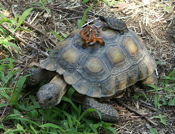 since I put them on the list.
I've also received permission to set up an Earthcache while up in Oregon, so that will take a little bit of our time while we're up there. I had asked for some advice from another cacher about setting up an Earthcache and he gave me some suggestions on who to write within the National Park Service where I want to create the Earthcache. He also said to not to expect any response for at least a couple of weeks. So I sent an email off and waited.......a half a day before I got a response back from the Natural Resource Specialist of the park basically saying that he was very excited about the prospect of me setting up an Earthcache in their park. So it looks like I'm good to go on that front as well.
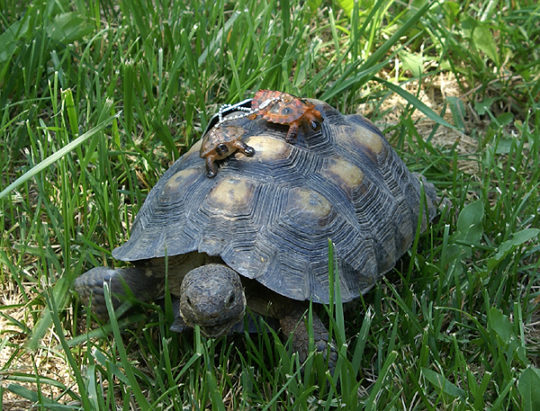
Now all I have to do make sure I get some decent pictures of the different bugs and coins before I let them go. I think I got a couple of good ones of Dude and Dudett already. That's Fred in the top photo and Ethel in the bottom picture. They are two California Desert Tortoises that live in my backyard. I've had them since they were hatched in August of 1999. Desert Tortoises are an endangered species and you have to have a permit (which I do) to possess them. It is illegal to release captive bred tortoises back into the wild because of the possibility of spreading illnesses to the native population. So they live in my backyard and will probably outlive my children. It's my way of helping a species survive.

Sunday, July 13, 2008
Tackling Tough Terrain: 5 Stars
We've seen what constitutes a Terrain Rating of "1". So, what constitutes a Terrain Rating of "5"? And, who the heck am I to think I know what I'm talking about? After all, I live in Northeastern Indiana - Flat, flat, flat, flat, and oh yeah, FLAT.
I've actually done 2 caches with a Terrain rating of 5, but one was a Liar's cache that probably had a "real" rating of about 2. The other one was a walk of about 1/4 mile or so from the parking lot to the boat dock, then a canoe ride to the boat dock by the cache, then another short walk to the cache itself. Without the canoe ride it would've been probably a Terrain 3. I've seen many, many discussions in the Geocaching Forums regarding Terrain Ratings - especially T5 - and I'm going to distill some of that here for you, and give you my perspective for the reasons behind the rating.
Geocaching.com says that any cache requiring "special equipment" (and no, a GPSr is not considered "special equipment" - it's standard equipment for any cache find) should be rated a T5. This is regardless of the rest of the terrain around the cache - if any part of the cache hunt requires special equipment, such as a boat, SCUBA gear, mountain climbing equipment, Sherpas, Yaks, oxygen masks, insert-your-own-equipment-requirements-here, that cache automatically gets a T5 rating.
A lot of people have taken issue with this mindset. "The rest of the cache hunt is a T1.5, at most! How stupid is this that I have to upgrade it to a T5 just because there's 500 feet of boat ride involved! This is the world's easiest boat ride, too! Just hop in, row-row-row-row, hop out!"
In one sense, they're right. That cache, were it completely accessible by land, would probably get a much lower rating. They feel their cache will be overlooked by many people who automatically filter (or PQ) for "caches with lower Terrain ratings", and they're completely correct. However, let's look at the Terrain rating from the finder's perspective, for a minute, and I think it will make the automatic T5 rating clear.
Ratings are provided as an aid to the cacher. How difficult is this find going to be - and how difficult will it be to get to the cache? If you're out running errands and want to find a cache or two while you're out, you're likely going to disregard the T5 caches, because most people don't take a Kayak with them while going out for milk. The T5 rating is there for much the same reason the "Unknown / Puzzle" Cache Type is - to let us know that we need to check the cache page for more information as to how to find this cache. What advance preparation do we need? Generally, a T1-3.5 don't require advance preparation; you can park the car, walk / wheel / bike / etc. to the cache, sign the log, and make your way back to the car. However, with a T4 and up, we know it'll require advance preparation or more than just walking to the cache. We'll need at least a hiking stick, and in the case of a T5, our "special Equipment", whatever that might be.
It is the responsibility of the Cache owner to specify in the cache listing what that Special Equipment might be. As with all caches, relying just on the star ratings isn't enough - for either the finder or the hider. A good hider / cache owner will provide a good description in the cache page of the obstacles the finder can expect. This way, the hider knows how the Terrain Rating was arrived at - is it because it's 400 feet up a sheer cliff? Across a shark-infested lake? At the end of a 3-day hike into the wilderness? Or possibly at the end of a SCUBA dive in the Black Lagoon?
In any case, if your cache requires Special Equipment to reach it, be it SCUBA gear or HAZ-MAT gear, a boat or Rapelling gear, your cache should be rated a T5, to let everyone know that they'll need to take special care in preparing for your cache, gather their special equipment needed to get to and find the cache, and that they should check the cache page for further information.
Good luck, and have fun placing your next T5: Tough Terrain Cache.
Saturday, July 12, 2008
Stuff Happens
Sometimes when you're out caching, nothing happens you have a great time and everything is good when you get home. 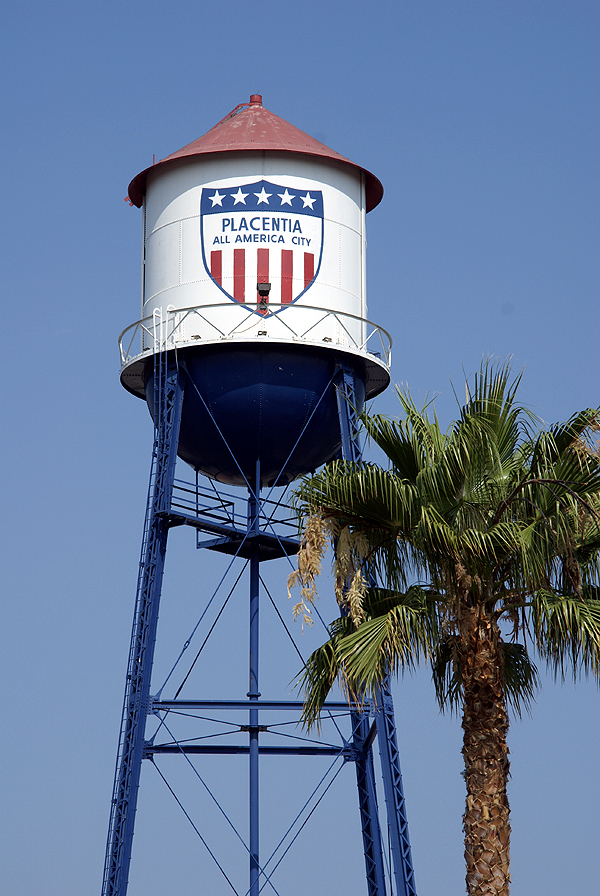 Other times, you can get injuries. Usually, they aren't life threatening, more annoying than anything else. But why does it always seem to happen all at once? I usually have a code about geocaching. It really hasn't been a good day geocaching, unless you bleed. Obviously, that's said tongue in cheek, so when I do scratch myself up, I can always say that and still have a good time. Today I didn't bleed, but I did get banged up and I still had a good time.
I took my younger son out to play with the GPSr today. The first thing we did was capture the flag of Bermuda. I wasn't sure whether it was actually going to happen or not, since I'd pretty much realized before we went that the flag was going to be behind a gate, but I figured that we'd get close enough that we'd score the point, which we did. We also waymarked a water tower today. I've mentioned that particular water tower at the bottom of this post, and we finally were able to get back to get it today.
The caching was fun. There was a neat puzzle that I'd solved about a year ago that I finally got around to finding. The rest were small caches, a couple of which had geocoins in them, another was large enough to place a travel bug in. But what happened to me at some of the caches makes me wonder whether I just should have stayed home. Let's see, let me count the injuries.
Injury one happened when I didn't heed the warning on the cache page. The warning stated,
"A note of warning, it seems many people are getting whacked on the head with this cache so please be carefull (sic) and watch your noggin."
Now, my thought process was that the cache could fall on you. I really didn't have a clue other than that until about 15 seconds after  I made the grab and suggested to my son that we sign the log back in the car, since we were standing under a staircase and I didn't want us to look so suspicious. That's when it hit me, literally. I smacked my head into the underside of the support beam of the staircase, the one I'd just ducked under when I went in to find the cache. My son volunteered to replace the cache when we were done signing the log, which I gladly accepted.
Two caches later I bumped my head looking for a cache under a bridge. After I came up for air, I noticed that the GPSr was now pointing 40 feet away from where I'd been looking under the bridge. Yep, that's where it was, but now I had matching bruises on each side of my head. The very next cache, although there was a good amount of time in between the two since we'd made a stop for lunch, I ended up slipping on a slope of grass and landed on my rear, rather unceremoniously. I have to give my son credit.  Had I been in that position as a youngster, I probably would have enjoyed a good belly laugh with that pratfall, but his main concern was whether I was all right. Not bad for a 12 year old.
Two caches later, in a parking lot no less, I apparently brushed my hand up against some stinging nettles. Now I've touched stinging nettles in the past and they really do sting. This felt exactly like it, but it was really in an odd place, in a parking lot, on one of the many landscaped islands that you can find in any local Big Box parking lot. Very strange, but over three hours later and my finger was still feeling the effects of it.
Fortunately, that cache was the last cache of the day, otherwise who knows where I'd be if I'd continued caching today, perhaps in traction? I guess this is more of a public service announcement more than anything. Injuries do happen. The slip could have been avoided, the head bumps as well. The stinging nettles was unexpected, but at least to protect myself in the future I need to remember to use glove whenever I'm working around plants of unknown origin. There's a lot worse things out there than just stinging nettles.
Pictures were taken at the following waymark:
Placentia Water Tower - by Webfoot

Wednesday, July 9, 2008
Terrain 1: what does it really mean?
Note: Many suggestions, ideas, and hints for this blog were taken from this article by Pyewacket. There's far more in that article than we'll cover here; I highly recommend reading it.
Okay, now for our article on Terrain 1! What does it really mean? The "accepted" definition is that any cache rated "Terrain: 1" should be wheelchair-accessible. Simple, right? Or....not.
Look around at some of your local caches rated T1. In fact, I'm going to choose a cache that sure does seem to be able to be rated T1. Note, I'm not picking on the cache owner, and I'm not trying to slam anyone. This is a demonstration that a Terrain of 1 isn't nearly as straightforward as you might think.
This cache, GC1D0MV is a great little stop-and-grab along the side of a road. It truly is an enjoyable little find. It takes you down country roads that even locals don't necessarily use much.
Here's a Google Map of the cache location:
View Larger Map
Right off the road! Definitely a T1! Only...it's not.
See, the cache is behind a couple trees, and there's a small "ditch", and some logs in the area. It also suffers from roadside non-maintenance: the grass isn't mowed. It's a fairly typical farm-field treeline area. While most average cachers wouldn't have a problem getting this cache, I can say from recent experience that there is no way your average Wheelchair-bound cacher is going to be able to get that cache. They'll have to do as I did, watch helplessly from the road, while their caching companion goes in and finds the cache. (Unless they happen to be named "Pyewacket", in which case I'm sure they'll figure out how to get that doggone cache - ONE WAY OR ANOTHER.)
So...what truly makes a T1? Think "HOF"
Hard-packed ground (including paved). Wheelchairs get bogged down easily in leaves, pine needles, dirt and sand. Even small stones and gravel can really bog down a wheelchair - and it's really darn hard to get free once bogged.
Obstacle-Free. Even if it's in a parking lot, if there's a curb between the parking area and the cache, it's not wheelchair-accessible. Look for "curb-cuts" (also known as wheelchair curb ramps) and make sure they're close to the cache. The Wheelchair-bound cacher doesn't want to have to go 1/4 mile out of the way just to get to the same level ground as the cache. Also, if there are cement parking "bumpers" ringing the parking lot, and the cache is on the OTHER side of those, that cache suddenly became at least a Terrain 1.5.
Flat. At least it should be wheelchair-friendly. A lot of hills, bumps, and uneven ground isn't going to be easy to pilot a wheelchair over, if it's even possible. Wheelchair ramps, curb-cuts, etc. are fine, as long as they're not extremely steep or abrupt. And while we're at it, make sure the path is wide enough for a wheelchair! A flat trail doesn't help if it's only a single-wide, teeny footpath.
Okay, you've found the ideal location. It's a decent challenging cache, not some parking-lot lampskirt micro, it's nice and hardpacked, flat ground, with easy access for wheelchairs. Now...where to hide it?
That stump is great. It's right next to the path; and it's deep enough that non-cachers won't find the cache right away. How about we put the cache there?
Whoops.
Wait a second!
Can a wheelchair-bound cacher reach that cache once it's at the bottom of the stump? Can they pick up a film can from the ground? Well....could you? Think about it. Sit in a chair - an office chair or kitchen chair should do - put your feet on a low stool, and then try to bend over and pick up a small film can. Can you do it? Can you do it without standing up, moving your feet, or tipping over? No? Neither can a wheelchair cacher. Try to keep your T1 caches within the reach of a reasonable seated person. Maybe it can go at the bottom of the stump - if there's a rope on it, attaching it to the top of the stump. I hear some types of fishing line work great for this sort of thing.
How about in that tree? Can it be reached from a seated position? AND, can it be put back from that same seated position?
Bet you didn't think that a Terrain 1 was so difficult to achieve, did you? Granted, not all the suggestions here really pertain to a "Terrain" rating, but if you're truly going to say "wheelchair-accessible" in your terrain rating, you might want to think about making the cache itself completely wheelchair-accessible.
Again, the linked article by Pyewacket has many other suggestions on how to make your cache truly Disabled-Friendly. Please do read it, and give a little more thought to your terrain rating before picking "Terrain: 1".
Up Next Time: "Tackling The Terrain of 5."
Tuesday, July 8, 2008
How's YOUR Terrain?
One thing I've become very conscious of since breaking my leg is Terrain Ratings on caches. It can be a great boon to the cacher, or a source of much hassle and confusion to the cache owner as they try to figure out "does this cache rate a 2 or a 3? What about if it's a 2 in the Fall but a 4 in the Winter? Why do they keep complaining about it? I can't control the fact that the trail in requires skis or snowshoes in December!"
So, Captain Spaulding and I decided we'd start a "series" of posts about Terrain Ratings. They won't be "DO THIS OR ELSE YOU SHALL PERISH" kind of things, just general guidelines that WE have come up with, based on OUR experiences and discussions with other cachers about terrain ratings.
Watch this space! Coming soon: "Terrain 1: what does it really mean?"
Sunday, July 6, 2008
Journeys
Saturday, our family went to visit my in-laws in  I’d planned on capturing a virtual flag which was very close to their house. We left fairly early in the morning, earlier than most times and I attribute that to the fact that my daughter wasn’t with us. She’s the one who ends up sleeping in and not getting up early as the rest of us. My 16 year old son has learned the benefits of sleeping in, but he was up by 9 AM and we were on the road by 9:30. Let’s face it, guys can get ready more quickly than girls.
Once up there, we sat around acclimatizing ourselves to the mountain altitude and then started fixing lunch. Lunch is always an experience at my in-laws house. I think one of the reasons my mother in law fell in love with me was because I ate her food, and lots of it. Needless to say, she pulls out the stops whenever we eat, even if it’s just sandwiches, which is what we had for lunch. Blondie’s Dagwood would be hard pressed to beat me in a sandwich making contest.
After lunch we went for a drive, basically to find a place to do a small hike. At first we decided to go up to 
The lookout station is manned by volunteers and you can climb to the top of the tower when it is occupied to check out the view. On clear days, you can see out to
We pointed out some of the sights to my older son who climbed the tower with us. I tried to point out the mountain peak that I used to identify with when I was a youngster, having grown up on the opposite side of that mountain down in  deal well with heights also stayed down below.
After coming back down, we drove over to capture the flag, worth 4 points for me in the game, and to do our hike. Getting over to the flag was easy, but capturing it wasn’t since the game dictates that you have to be a minimum of a 100 meters to capture it and we were stymied by a road closure that kept us a quarter mile from the flag. I knew there were other access points, but they would require bushwacking, which would be out of the question for my nearly 80 year old father in law and my 76 year old mother in law, so we found another trailhead on which to hike, with a nice level terrain along the waterfront.
Everyone had a good time. We got some pictures on our hike and we tired the dog out. He slept most of today and at this moment is sleeping near the feet of my wife in the other room. What I was most impressed with were my two sons. When their grandmother got tired near the end of the hike, one of them and then the other in turn assisted her back to the car, helping her along, just by being there for her to lean on for support. I know I probably didn’t have that kind of compassion at ages 12 and/or 16.  I was pretty self indulgent as a kid and didn’t grow up for a long time. I was glad to see them taking care of other family members in need.
Each day I thank God that my kids have all four of their grandparents. By the time I was 13, I had none. I’m thankful we live close to them so we can visit. I grew up in

Friday, July 4, 2008
The Mother Road
Yesterday, while caching in Victorville, I had the opportunity to log a virtual entitled, Route 66 - The California Route 66 Museum. The cache itself isn't much, being a simple, "answer this question and email me the answer before you log it" 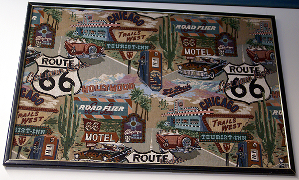 type of cache, but the museum that is at ground zero is absolutely amazing. My caching buddy, 3blackcats, had already been to this cache, but she encouraged us to go and see the museum. It's definitely worth the trip here.
The museum used to be a restaurant called the Red Rooster and was the filming spot for the 1980 film, "The Jazz Singer" starring Neil Diamond. I might have to rent that one now, just to see if I can recognize some of it. The inside is one gigantic tribute to Route 66, the Mother Road. I had been to another Route 66 museum down in San Bernardino about a week ago when I visited the first McDonald's, but this one is by far and away much classier and better organized.
This museum serves up a large slice of Americana that many of us probably got first hand on many long road trips to parts unknown. You don't have to have driven part of the Mother Road to appreciate what this was like, but if you have, you can look at many of the exhibits and think to yourself, "Oh man, do I remember that."  I remember the many different kinds of gas stations that were out there. The one that I always looked for was the Sinclair Dino Gasoline. After we'd left the museum, we spotted an old Mohawk gas station, boarded up now, but still able to evoke strong memories of the road. Most of these old station signs were represented in some form at the museum, but most today are gone except in places like this or in our memories, to be replaced by the giant gas companies that consolidated everything in the early 70s.
I saw a gas sign that was selling gas for 31 cents per gallon. I can remember one time my dad taking us to get gas in the car. Sometime that day, the price had gone up from 27 cents per gallon to 31 cents per gallon. Whoever had reset the pump had reset the 7 to a 1, but had neglected to change the 2 to a 3, so we were buying gas at 21 cents per gallon. I thought my dad was going to have a kitten. He filled up the car, raced home and got the other car and every available gas can we had in the garage at the time and went back and filled all of those up at the gas station that evening. What a bargain.
There was an interesting trailer on display in the museum as you walked in the front door. It was a very small, about 10 foot long trailer, big enough for a double bed inside. On the back was a kitchen that opened up complete with two burner stove. It would be perfect for a young couple working their way across the country, camping in spots along the way. It brought back memories of some of our camping trips, especially the 1968 trip where we literally drove almost the entire length of Route 66 getting back to Indiana for my grandmother's funeral. After the sadness, we spent the better part of 6 week enjoying family and slowly making our way back home on a more northerly route.  Even though it started our poorly, it ranks right up there with one of my fondest memories of camping with my family.
Knowing that my dad liked to travel through the desert at night, we started at 7 in the evening, getting to Needles, CA at midnight to gas up. The temp was 100 degrees. Three hours later we were in Flagstaff, AZ looking for another fillup or perhaps a potty break. We were cocooned inside our air conditioned station wagen and here comes the gas attendant wearing a heavy coat and mittens? Something wasn't quite right here. When we emerged from the car, we understood immediately because the outside temperature in Flagstaff at 3 in the morning in the middle of July was 39 degrees.
We later made it to Amarillo, TX and had dinner there on this same trip. The wind was howling and it looked like thunderstorms were in the offing. I can remember another gas attendant stating that it looked like possible tornado weather. I've never seen my dad get so frightened, nor move so quickly to get everyone done with dinner so we could get back on the road to get ahead of the storm. We never did get rained upon, but that was another side of my dad I had never seen before.
After touring through the museum and taking several pictures of some very interesting things, we stopped by the gift shop. I bought an obligatory Route 66 t-shirt, plus a postcard that I will be sending to another geocacher.  Later in the day, we made our way home by way of the Interstate 15. Just north of where the 15 divides into itself and the 215 you can see the old Mother Road down in the canyon and watch it as it parallels the Interstate, getting closer and closer. At the junction of the two interstates, right at Devore, CA, they overrun the Mother Road and obliterate it entirely. Just south of there, it comes back into being once again. Fortunately for me, I see reminders of the old Route 66 all the time because I only live three blocks from the road as it makes its way through my town.
By clicking on the link above, you can get the coordiates that will take you directly to the museum. For those of you who aren't geocachers, you can get to the museum here:
California Route 66 Museum
16825 D. St
Victorville, CA 92392-2151
Telephone (760) 951-0436
It's well worth the visit. Oh, and that first picture at the top? It's a needlepoint design.
Pictures were taken at or near the following geocache:
Route 66 - The California Route 66 Museum - by Parsa

Wednesday, July 2, 2008
The Sounds of Caching
We all see the sights of caching all the time. For the most part, caching is a very visual experience, which is one of the reasons why we spend so much time making the camo on our caches just right. 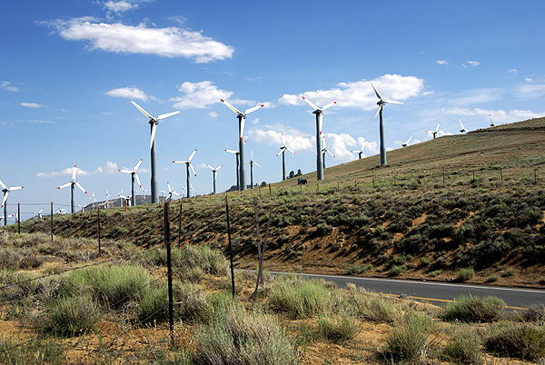 Even on a hike, we primarily use our sense of sight to enjoy the scenery as we make our way to ground zero and the cache zone. Very rarely do we use our ears.
Last week, I was fortunate enough to find one of those caches where the area literally sang to us. The cache is called Pass Cache, and it's located along the Tehachapi Willow Springs Road, right at Oak Creek Pass leading from the Antelope Valley up and over to Tehachapi. It's also an area of high winds and there's some enterprising business that's taking advantage of it by placing windmills all through the area. If you've ever been through Palm Springs along the I-10 leading away from Los Angeles toward the Colorado River, you know what I mean. These windmills are huge and they catch the wind and generate electricity.
Now, whenever I've driven out to Palm Springs, I never had my windows open, mainly because I'm driving 70+ mph along the interstate and it's usually hot out, so I have the air conditioner going as well. I've never had the chance to actually 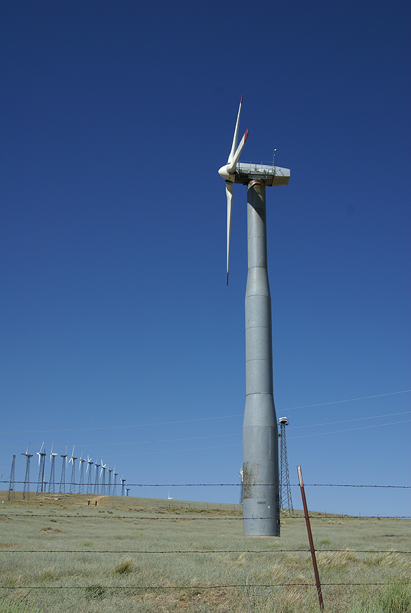 hear what these windmills sound like until our encounter with the windmills near Pass Cache a week and a half ago. It was really eerie.
As soon as we got out of the car, my prime concern was finding the cache. It was hot that day and we hadn't been spending a whole lot of time outside of the car because of it. Immediately I was struck by the sounds I was hearing. To me, my first impression was that of a very large windchime, the kind that many people have in their back yards that catch the breeze and give back pleasant tones on a cool summer evening. These were just like that, only very deep in pitch. We kept hearing different frequencies, but there was an ethereal quality to it all that made the entire experience quite haunting. I noted to Chaosmanor what I thought it sounded like and he said that he heard singing.
Hmmmmm. Now I couldn't hear the singing that he defintely said he heard, so in my mind, that made the place even more interesting. We were hearing the same thing, yet they were saying different things to each of us. Then I heard the singing too. About five feet from where the cache was hidden, there was a benchmark, so I had to go back to my car to get the camera so I could document it as well, and that's when I heard the singing. It literally sounded like some kind of Gregorian chant, or possibly some druid elves chanting to each other. You couldn't understand it, but you definitely knew it was singing. It was a very cool effect and all done by the wind and these windmills.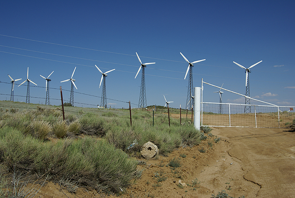
Usually on a large cache hunt like I did that day, I'll go back over them and think about the coolest cache that I found that day. I keep a running 5% bookmark list, of what I consider the best caches that I've found. The list is constantly in flux with additions and subtractions occuring when some caches get archived and when I find new ones that I think fit the bill. The list includes caches that I find whimsical, or that I found particularly challenging, or they could be on the list because of the great view. This one was a no brainer to make the list because of the experience. I got to find a cache, I got to document a benchmark and post a visit at waymarking and I got sung to all at the same time. You really can't beat that in my opinion.
Pictures were taken at or near the following geocache:
PASS CACHE - by rborch
