I've been following the travels of Elemental Jay via his blog EJ Rider. He's in the process of taking a cross country road trip from Indiana to the west coast and 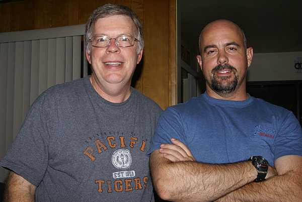 back again via his Harley. Today, I got to see the Harley, up close and personal. Oh yeah, I also got to meet Jay as well.
Jay was waiting for me in the parking lot of my school this afternoon when I got off of work. We drove to a nearby coffee shop where both of us had fruit smoothies. We talked geocaching for a little bit and I think I convinced him that driving all the way to Kingman, AZ this afternoon wouldn't be a good idea since he was going to hit major traffic along the way, so he came back to my house for some dinner and some geekiness of posting in the forums and talking to each other on line while we sat in the same room together. We've both been certified as 100% geek by someone else who is near and dear to us.
He caught up on his latest blog postings while I cooked dinner of salmon, angel hair pasta and peas topped off by some homemade cookies and cream ice cream. The food was good, the company was excellent, a nice way to spend Halloween. There was a Haunted House going on across the street from us, but for some reason, we didn't have many trick or  treaters tonight, yet we could hear lots of screaming going on across the street, not all of which was by the actors in the house. It kept the distractions to a minimum.
Jack, our dog, on the other hand was easily distracted and barked at anything that seemed out of the ordinary, which was quite a lot this evening. Eventually, he settled down and made a friend of Jay. He was quite content to stay right by Jay's side for most of the evening, in between barking at all the strange people that kept walking by the house. Eventually, Jay decided that he needed to continue his road trip. The plan was now to drive an hour up the I 15 and get to Barstow for the night, a ride of about an hour or so from my house. It would probably be a pleasant enough ride since the temperatures here have been hovering in the 80s and 90s for most of the month. All in all, I have to say it was a pleasant evening and it's always nice to finally meet a fellow cacher who you've only known via postings in the forums in the past. God Speed Jay on your trip home.
Friday, October 31, 2008
Meetings and Greetings

Sunday, October 26, 2008
Self Inflicted Goofiness
Back in April, while I was recuperating from my surgery, I posted this, which talked about oddities 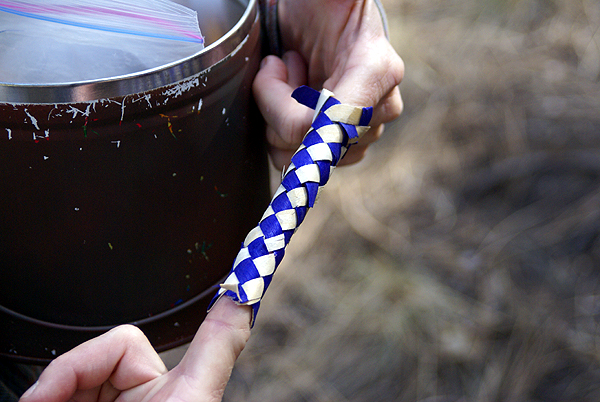 found while geocaching. As I was looking at a recent picture I took, I realized there are also oddities, or as I like to call them, Self-Inflicted Goofiness out there. I looked through my pictures and it was either some silly picture, like 3blackcats "getting stuck" in some finger cuffs. Now everyone knows that finger cuffs are really easy to get out of, but at that point in our hike, we were tired and hungry and a little punchy, so it became almost a running joke, especially since we were finding finger cuffs in every cache we encountered along the hike. So, finally, I took a picture.
Sometimes the goofiness is part of the fun that goes along with the cache find, or in one case, the geocoin find. I found this one geocoin and the owner wanted pictures of people with it placed on their eyes much like you would place a cucumber at a spa. Well, I didn't have anyone else around to help me out on that one, but I tried my best. It's just a silly picture,  but it was fun to do.
A cache in my local area presented itself with an opportunity for some goofiness and I took advantage of that one as well. It actually would have been a real treat had the bathtub been full of water that day because I remember the heat index that day being extremely high. The one thing I do remember is I'm pretty sure that I'm the only one in our group that actually decided to get in and have my picture taken. Most of my caching buddies would probably say it was because I'm a frog, or at least I represent myself as a frog as my geocaching persona, while they represented themselves as cats or other such creatures that don't like the water. What ever it was that day, I had fun posing for a picture in the tub.
Sometimes caches have certain requirements. I saw a cache once that had a requirement for logging that any cachers of the male persuasion had to dress like a female in order to log the cache since the cache was for "Ladies" only. Some of the pictures in that gallery are hysterical. My 2000th find was very similar to that. I'd searched out an area looking for a large sized cache in order to log my 2000th find. I found the cache 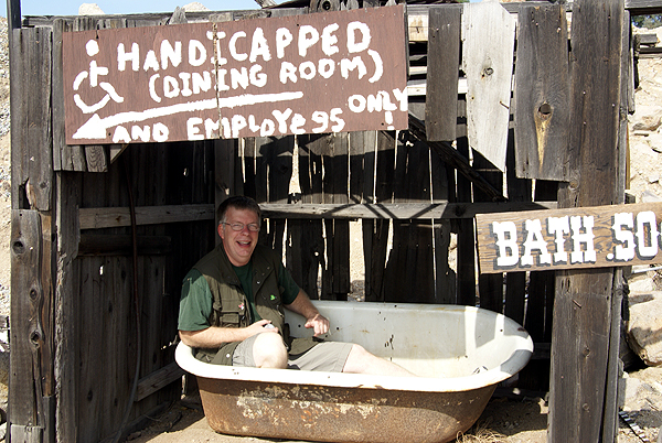 that I wanted to find, and early this past summer 3blackcats and I went out to find it. I knew there were some logging requirements for the cache. Actually, the cache says that if you wear what's in the cache and post a picture of yourself, then you could log it twice. Well, I really didn't want to log it twice since that's not the reason I go out and find caches, but I was in a pretty good mood that day, so I decided to don the garment and get my picture taken at the cache site anyway. It was a fun day and a memorable cache find, especially for one of those milestone caches. It was definitely better than finding an Altoids tin under a lamp post skirt.
What's really cool about most of the pictures that happen to be at caches like this, is that most of the people really enjoy doing goofy things like this. It's probably in our nature to act a little goofy. I know most of my friends and definitely my wife will say I'm more than a little goofy to begin with, but that's the fun of it. Enjoying your hobbies, not taking them too seriously and having fun out there is what it's all about. That's why it's important to be silly or goofy every now and then. Gaawrsh.
Pictures were taken at or near the following geocaches:
2N27 Sand Canyon - by Badgerdawg
Woodyk's #1: Home on the Range - by Woodyk
RUB A DUB AT P.M.C - by UNCLEJON91 (JONEDI)
Altigenman's Wedding - Anything for smiles! - by Altigenman

Friday, October 24, 2008
Natural surprises
Every now and then I'll get some decent pictures while I'm doing some urban caching, but most of the time, I very rarely take pictures. How many pictures can you get of Wal-Mart parking lots while checking under a lamp post skirt?
Usually, it's the pictures while out on a hike I find most interesting. Sometimes it's just little things, like a layer of rock that's a different color than the surrounding rock. 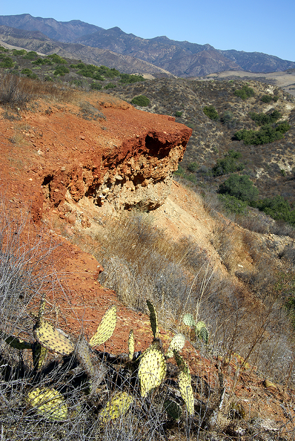 The capstone formation of rock on the hike that we took a couple of weeks ago down near San Juan Capistrano was extraordinarily red in color. It reminded me of Bryce Canyon National Park in many way. I remember remarking about the trail and the surrounding area reminding me about a similar trail up near Claremont where I live. There is a cache on that trail called Flashback. The cache owner called it that because it reminded him a lot of trails that he'd ridden in Utah. So it's like a three tiered remembrance of a basic spot if you like, but the point is the area reminded me strongly of Utah due to the red rock capstone on which we were walking. In the shot, I felt everything came together quite nicely. You wouldn't know there's several million people living just 10 miles to the left of the view in the picture.
Other times, the pictures sneak up on you, or rather the spot sneaks up on you and you end up taking an interesting picture. The large bracken fungus that we found last week was just attached to this downed tree. The thing that stood out about it was its size. The picture doesn't really do it justice. I estimate that it was at least 8 to 10 inches in length. It was really fat, which I think contributed to it, but the size, coloring and overall appearance of the fungus made me think someone had wedged an extra large pancake into the side of this tree. You can almost see the syrup running over the top of the pancake and down the side.
A little bit earlier in the same hike we had to climb up on some rocks to find a cache. Along the side of the largest boulder, which was probably the size of a small house, was a little sapling clinging to life in a crack on the side of this boulder. I have to admit, it's a terrible picture of the tree because it just blends into the rock and such. 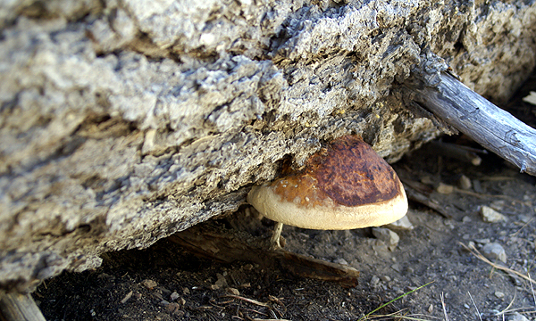 The lighting is poor, but I liked the way the tree was clinging to life, making it work. It was a surprise for us to see this little tree growing there. In ways it reminded me of the Jeffrey Pine that used to cling to life on top of Sentinel Dome in Yosemite National Park.
That pine tree clung tenaciously to life for several hundreds of years, growing to a height of only about 10 fee tall. Lightning and lack of any kind of soil on this exposed piece of rock contributed to its stunted condition. Sometime during the drought of the late 70s, it finally died. I had photographed it several times before it died and I have a black and white picture of it that I took in August of 1975. I processed it in our photography lab in high school and it still hangs on the wall in our bedroom. In 2000, the last time I was in Yosemite, I took the kids and we hiked to the top of the Dome. I had been in denial for many years, refusing to believe that my favorite tree had succumbed, yet knowing it had. When we reached the summit, I said hello to my old friend, now long dead. We took several pictures of it and with the kids around it. My older son's picture turned out so well that we made it his "school" picture for that year. Two years later the tree further succumbed to the elements and is now downed. Weather permitting, we'll try to make it to the top of Sentinel Dome again and see what's left.
I have another picture of another tree in a similar situation. I was with a group that was beginning a backpacking trip into the Sierra from the eastern side at Mammoth Lakes. We'd spent one night on the eastern side of Owens  Valley in the bristlecone pine area and were going to spend a night in Reds Meadow near Devil's Postpile National Monument. On top of the postpile, the columns are worn smooth from glaciation that moved through the area during the last ice age. Many of the columns are six sided shapes and the top of the postpile looks like a giant patio created from interlocking stones. I took a picture of a small sapling growing between a couple of these columns. It was about two feet tall at the time back in 1977. I keep thinking that one of these years I should get back there to see if it's still around. With the amount of traffic the postpile gets on an annual basis, it's likely that it didn't survive long, but if it did, I wonder what 30 years with little soil to help it along would cause it to look like?
Over the course of time that I've spent geocaching, I've come to appreciate the subtleties and little surprises that happen out on the local trails. I like to travel to national parks to do my camping and to appreciate the beauty this country has to offer. But I've come to realize, that I don't necessarily have to travel thousands of miles to find that beauty or see plants defying nature. Much of it can be found in my own back yard.
Pictures were taken at or near the following geocaches:
East Ridge - Red Rock - by chaosmanor
Hawk Hill - by Badgerdawg
4 Corners Among the Boulders - by RAD4SAND

Wednesday, October 22, 2008
Odds and Ends
This one is more of a quickie than anything else. In a couple of weeks, I'm going on another road trip to Stockton to visit with my daughter. She's the concertmaster of her college orchestra and the orchestra will be performing on the 8th of November. I'll be leaving in the morning and getting up there in time for the concert. I emailed her yesterday asking her what she wanted to do the next day, since I wasn't going to be leaving until Monday the 10th. I suggested a road trip to Yosemite National Park, which is about an hour and a half to the east. She's pretty excited about that and is planning on asking a couple of her friends along for the ride.
Now, I've started checking out the possible caches along route 120 into Yosemite Valley. There's lots of virtuals, but also several regulars just outside the boundary of the park, including a travel bug and geocoin hotel. Right now, I have two bugs and a geocoin that I'll be bringing along on the trip. I plan on writing about this particular trip a little more in detail in the coming week.
Last, but certainly not least, there's a new link on the right hand side of the of the blog page. It's a spot to allow readers to follow along. Something different just to see who's reading this on a semi-regular basis. Feel free to add yourself, or not.

Tuesday, October 21, 2008
Dreadnaught Memorial
 About a month ago, I was at a Dreadnaught Memorial, a "memorial dedicated to the soldiers of the 2nd Battalion, 34th Armor, who served in Viet Nam from 1966 to 1970." The cache page notes that the memorial (seen below) lists the men who served during this period. Some who served didn't come home.
Obviously, there is a cache hidden near the memorial. I'd been out there last year and couldn't find the cache and wasn't able to find it the second time I looked this September. Both times I'd been by myself. The next time I went out on  October 11th, the day Chaosmanor, the Tadpole and I went on our 5 and a half mile hike near San Juan Capistrano, we made it a point to stop by there again and find the cache.
This memorial is placed in a very weird spot. It's located in an industrial are of warehouses and workshops. You can see it from the frontage road alongside Interstate 5, but if you're traveling north, you've already missed it. If you're traveling south, you need to drive almost a mile to finally get access to the memorial over some railroad tracks. Then it's up to your geosenses to lead you back to the memorial. Were there not a cache there, it would be very difficult to navigate the streets and back alleys that we had to negotiate in order to get to the memorial and the cache. To give you an indication as to how difficult it is to find a correct route back in there, the cache owner puts four different waypoints on the cache page to help get back to it. Since this was the third time I'd been back there, I really wasn't worried about getting back there this time.
Once we got back to the memorial, I knew we'd eventually find the cache with three pairs of eyes and we did, but it took us way longer than any of us figured. How can a coffee can elude three experienced caches the way this one did? I really don't know, considering that three of us, at various times in the search, all put our head into the bushes and literally had the cache right beside our left temple. I still can't believe that I missed it the other two times. Chaosmanor spotted it about three seconds before I noticed it from the opposite side from where it was hidden. We both just looked at each other with these incredulous looks that said, "How in the hell could we have missed that one?" Well, we did.
I made it a point to take some pictures at this one. I didn't take my camera with me on a trip down to Orange County a couple of months ago and missed getting 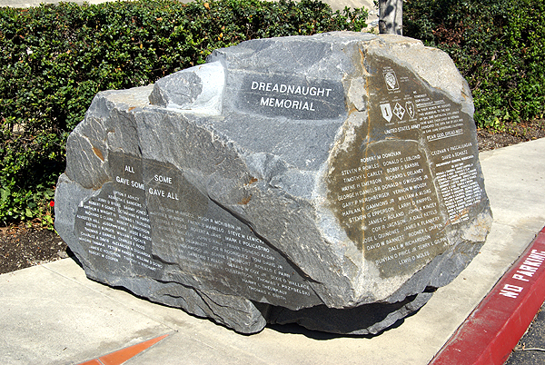 some really nice and moving pictures of a Vietnam Memorial Virtual there. I vowed that I wouldn't make that mistake again when I'm near a memorial.
Pictures were taken at or near the following cache:
Dreadnaught Memorial - by Dave_W6DPS

Sunday, October 19, 2008
It can be done
Yesterday, my friend 3blackcats and I went hiking near Big Bear, California. We did a loop hike near Moonridge which is close to the Snow Summit Ski resort located in the same general area. 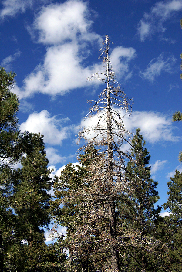 The hike was 3+ miles or so. I forgot to zero out my odometer on the GPSr, so I'm estimating. The overall hike was probably longer than that because most of the caches along this loop were several hundred feet off trail. We found 16 caches along this loop plus 8 more alongside the road going to and from this trail. The amazing thing about yesterday was that every single cache wasn't a micro.
We weren't trying to not find micros, but every cache on the loop was labeled either a small or regular sized cache. Granted, since this was out in the forest, one would expect the caches to be on the larger size, but I've been on hikes where you could walk 2 miles just to find a hide-a-key hidden on a tree somewhere. Even the small caches were large on this hike. There were several times we were looking for something small only to laugh when we finally found the "small" cache that was a very large cookie tin, just slightly smaller than a regular ammo can. Our only thought was they just grew caches larger up in the mountains.
Initially, we'd decided to go up to a cache that I'd already found back in July 2001 the year I started caching, just to see if it was still there or at least in the same condition. We found it and 3blackcats signed the third log book. We looked through and found the original logbook from 2001 and found my entry from July 11, 2001, my anniversary. I can remember because when we went up there,  I lost track of the time, so I called home to let my wife know we were running late only to get my daughter on the phone. Now this was surprising, since I knew my wife should have been home. Even more surprising was my daughter's response that my wife was out because she was interviewing for a job that afternoon, a job that she still has today. That was an interesting day to say the least. My only regret about retracing my steps on Saturday was that I didn't take a picture of the old log page for posterity.
After getting three caches in that area, well two for me, since I'd already found one of them, we headed over to the loop and walked that, taking a good three hours to traverse the entire loop. The trail had a lot of variety in the types of caches. There were several nice spots for pictures and I didn't have to worry about waiting until I found a good sized cache to place a couple of travel bugs that I had in my possession. Even the larger travel bug would have fit in almost every cache we found. One of the caches also had a White Jeep travel bug. I haven't seen one of those in a couple of years.
Evidently, we were pleased with the size of the caches we found. Even on the ride home, the caches were large. 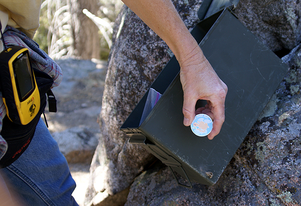 There were several turnouts on the way home, many that had caches hidden near them. The thing that stood out was that the cachers in the area appeared to have taken the time, not to just slap a hide-a-key inside a guardrail at the turnout, but to walk 40 feet away from the turnout so they could hide an ammo can, or a large cookie tin or something of similar size. The quality of the caches we found on Saturday made us start to make plans to come up to the area again. There are many off-roading experiences up in the area that had caches along them. It appeared like we could make several caching runs into the Big Bear area and find a great deal of quality caches. It's something to look forward to in the future.
Pictures were taken at or near the following geocaches:
Hawk Hill - by Badgerdawg
Bristlecone Trail - by Badgerdawg
Rocky Raccoon - by Team Geo-Rangers

Wednesday, October 15, 2008
Thinking outside the box
Yesterday, for the second day in a row, I went out caching after work. Both days, I found three caches. That was fine since I was only looking for larger sized caches. I had decided that I wasn't in the mood to find any micros, so I just pulled them out of my query for these two days and just went for small or larger. Now some people will argue that an Altoids container is really a micro, but I figure that if you can fit a geocoin in the container, then it should be a small. But I digress.
My second find Wednesday was one of those Altoids containers, painted to look like it's surroundings and hidden in plain sight. That's one of the reasons it made my top 5% bookmark list. This particular cache, View of the Birds, by UncleJon was a round Altoids tin with a couple of magnets glued to the inside of the cache. Inside the cache was the standard log book and a couple of marbles, which are Jon's signature item that he places in his caches.
When I first started looking for the cache, it appeared as if I was going to be stymied. I'd searched in all the logical places and had started back to my car. I had the car door open and decided to make one last look back at where I thought the cache was, when it hit me that I was looking in the wrong spot. All of a sudden, the clue made sense and everything fell into place. I made my way over to ground zero, quickly found the cache, signed the log and returned the cache to its hiding spot. When I got back to my car, I looked back again and there was the cache, hidden in plain sight. This was definitely one of those "thinking outside of the box" type of caches, a worthy addition to my top 5% bookmark list.

Sunday, October 12, 2008
Forgotten Trail?
Yesterday, Chaosmanor and I hiked a loop trail in the Ronald W. Caspers Wilderness Park just north of San Juan Capistrano. It's a very large park and we were there primarily to get a dashpoint that had been positioned by the GPS Games computers near the north end of a couple of trails. 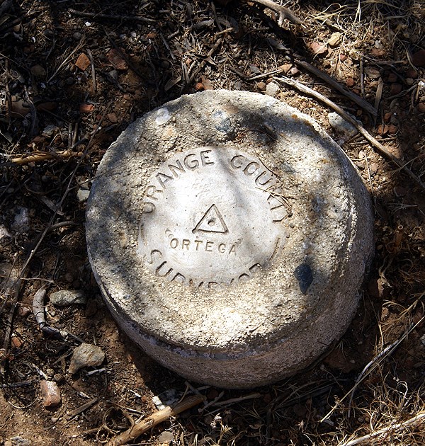 There were several caches in the park, so we were planning on making it a nice hike with some caching. The weather was perfect; we couldn't have asked for a more perfect day.
The trail we'd chosen to get to the dashpoint was called the Eastridge trail. It was a short hike up from what was called the Quail Run trail up to the Eastridge trail. We have views to the east of the Ortega Hwy and the valley that made up most of the park to the west of the ridge. Interestingly, there was only one geocache that we noticed along this trail. As we made our way over to this cache, we spotted a benchmark, or actually Chaosmanor spotted a reference post noting a benchmark, which was very close. The trail actually had a paint mark on the ground pointing to the benchmark.
This was one of those spontaneous finds. We hadn't really looked at the possibilities of there being benchmarks along this trail and we just happened to find this one. When I got home I was pleasantly surprised to see it in the Geocaching system. We took our requistite pictures of the dashpoint and then made our 60 foot walk down to where the geocache was supposed to be.
After about 10 minutes of searching, we consulted our PDAs and found the cache to have been DNFed back in November of 2007 and not found since before March 2007. Ground zero yielded a rather large packrat's nest, but nothing that looked like a decon container. We eventually expanded our range out thirty and forty feet, but couldn't come up with the cache. I posted a DNF last night and within minutes, the cache was archived. I think had we know the cache had some possible issues, we might have taken another route, but then we wouldn't have found that benchmark, nor the o ne further on down the trail. It's one of those "Roads Not Taken" type of situations.
We started making our way north along the Eastridge trail commenting about the lack of caches along the trail. Chaosmanor brought a small container that we used down the trail to hide one cache, but there could have been quite a few nice caches hidden along this trail without even getting close to the cache saturation level. It's almost as if this trail had been forgotten by the locals here. Either that, or they're still working on it. I prefer the latter approach because you could say the same thing about the Claremont Wilderness Park near my house. There are still some great areas for caches, but I haven't gotten around to it yet. Eventually, as I'm sure the locals down there will do the same over time. It was just surprising to see this long trail with only one cache on it.
After Chaosmanor hid his cache and we checked (beta-tested) his coordinates, we continued along the ridge toward its northern terminus. At the junction of two trails at the north end we found another benchmark and a nice reference post pointing to the benchmark. We took our pictures of this benchmark, marveled at the nice view and noticed a game trail leading beyond the two trails, where it looked like another decent cache could be hidden. We then made our way down to the dashpoint. We needed to be 100 meters (328 feet) or closer to the point to score. At the top of the ridge, we'd gotten to about 500 feet away, so we figured we'd get closer heading down along the second trail. Well, we got a little bit closer, but only to 400 feet along the trail, so we had to do some bushwacking to get within scoring distance. Once we got to 296 feet or so, we figured we were good. To zero out on this one, would have meant hiking down into a draw then back up the next ridge and over it, bushwacking all the way. Nah. We scored and that was good enough for this particular game.
The hike back down to the car netted us 5 well done larger caches, one very well cammoed that the Tadpole got to first. He was pretty proud of himself with that find because it was well hidden in plain site. Back at the car, the GPSr's internal odometer showed us we'd hiked 5.46 miles. It gave us a good workout as my calves will attest to this morning. Five caches found, two benchmarks logged, one dashpoint scored and a good hike with friends and family made it a very good day, one of those geocaching days that will stay with me for a long time.

Thursday, October 9, 2008
Surprising Results
Going to be heading down to Orange County to grab this particular Dash Point. We got lucky when the computer program for this month set that one up. It's in Ronald W. Caspers Wilderness Park very near a fire road trail, so it should be easily reached after about a two mile hike or so. I ran a PQ centered around that point and got the strangest looking PQ map I've seen in awhile. This is a pretty rural area but I was still expecting to see more caches along the Ortega Hwy. The arc to the west is in urban Orange County, but the nothingness to the east of the center of the PQ was surprising until I thought about it. The area to the east is pretty rugged and mountainous. I think I was surprised that there weren't more caches hidden along the Hwy. I guess we'll find out when we get there on Saturday. It could be that it's not safe to stop along most of the road. If you're not from this area, the grey area to the south is Camp Pendelton Marine Corp Base.
The Dash Point is in the center of the map and we'll be going for the caches located there. Most of them are along the trail and so they're not micros, but good sized caches. When the Tadpole found out about that, his immediate reaction was, "Score!" I have to agree with him. I'll be sure to take the camera along to get some pictures.
Another surprise was I couldn't find a public route query for the highway either, so I had to create my own. That wasn't too much of a problem. Just opened up Google Earth and asked for directions between San Juan Capistrano and Lake Elsinore. That gave me a route that I saved to my computer which I then uploaded to Geocaching.com. I put in some parameters for the route and came up with 69 caches along the route, most of which are centered around San Juan Capistrano and up around Lake Elsinore. There really aren't that many caches along that route. I've made the route public. You can search for it using keywords, Ortega, Elsinore or Capistrano.
