Every now and then, you run across a cache where you think you're smarter than the cache owner. I've had that happen on one of my caches, where I wanted cache finders to come in one way, but they came in another way. To be perfectly honest, I hadn't even explored that possibility when I hide the cache. I've gone in both ways and they both are adventures, although adventures of a different kind. One is a nice trail, the other requires more bushwhacking.
The Tadpole and I ran into those circumstances while up in Lassen earlier in the month. The cache is located just outside the park boundary on the western side of the park. 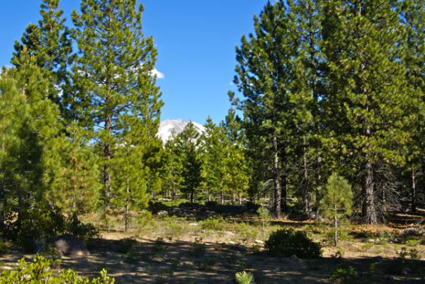 There appears to be several possible access points leading to the cache, but the cache owners give only the western one. Well, we didn't feel we needed to follow the cache owners instructions, because we're smarter than the cache owner. Why hike six tenths of a mile, when you only have to hike .17 miles? Sounds easy, right?
Wrong. If you look at the cache page, the satellite view of the cache area shows the cache to be in an open area, surrounded by some sparsely scattered bushes. Well, from ground experience, those sparsely scattered bushes were a dense, impenetrable wall of manzanita bushes. Scratchy and very dense, it wasn't pleasant trying to bushwhack through those and we gave up, not once, but twice. We tried from the east which was a third of a mile away. No go. We tried from the north which was only .17. That was even worse.
The Tadpole wanted to try from a service area inside the park, which upon closer inspection shows the other end of the trail that is described on the cache page, but by that time, I'd decided that I'd already donated too much DNA to the surrounding plants, so we went in the cache owner's way. I was able to get the van in to about a half a mile before we hiked the rest of the way in. It was an adventure, but I need to remember if in doubt, follow the cache owner's guidance. They've been there before, you haven't. The shortest distance between two points is not necessarily a straight line.
Picture was taken at or near the following geocache:
Loomis - by 2dogs and mtnsteve
Friday, July 30, 2010
Straight Line Caching

Wednesday, July 28, 2010
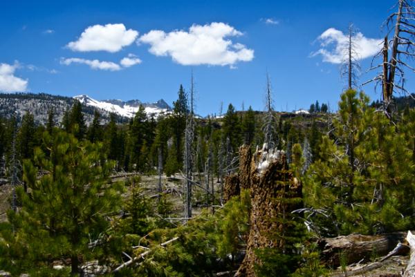
Lassen
There are a couple of national parks that protect historical and cultural treasures within our country. 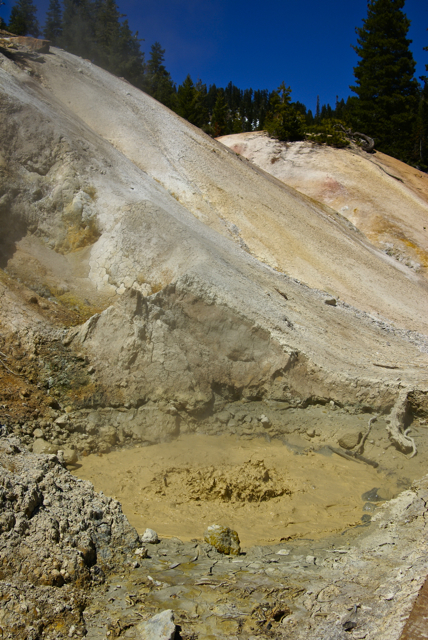 Most, if not all, protect scenic beauty and many also protect geological wonders. Lassen Volcanic definitely falls into the latter two categories.
One of the nice things about Lassen Volcanic National Park is it is one of the least visited national parks in the lower 48 states. Consequently, there are very few crowds in this park, even on a busy weekend. We happened to be at the park during the 4th of July weekend and were only confronted by crowds once, and that was in the visitors center. Once we were out on the trail or the park road, we encountered very few other people. Even the campground wasn't totally filled on that weekend, which I found surprising, since there is a substantial population to the west concentrated in several towns in the Sacramento Valley.
Probably one part of the equation was the winter we've had in California earlier in the year. The Sierra Nevada and the Cascade range got a large amount of snowfall this year. Hikers we encountered on the John Muir trail spoke of walking more often on snow as opposed to terra firma. One couple we spoke with told us there wasn't any trail to follow, so they were just following other's footsteps in the snow.
Snow in the high country isn't unheard of, but it's surprising to see that much of it, especially in late June and early July. My wife and I were in Crater Lake National Park on July 19th, 1987, basically snowed in. A storm had moved through Northern California and Oregon the day before and dropped a foot of brand new snow on the rim of the caldera. The rim drive had been shut down. It made for spectacular scenery, but it's a little disconcerting wearing winter gear in the middle of the summertime.
Lassen's elevation varies from around 5000 feet above sea level up to just over 10,000 feet at the summit of Mt. Lassen. The high point for the road that traverses the park is 8100 feet. As I noted in another post detailing where we would be going camping, we knew there would be snow at Lassen. We also knew the road was closed, but I decided to gamble that the road was open by the time we'd get there. I lost that gamble.
That didn't deter us from seeing the park. The major thermal area of Bumpass Hell was off limits due to the heavy snow. However, the small area of Sulphur Works, which is right by the road side was open. We got to see boiling water, colored a mustard yellow color and fumaroles steaming away. 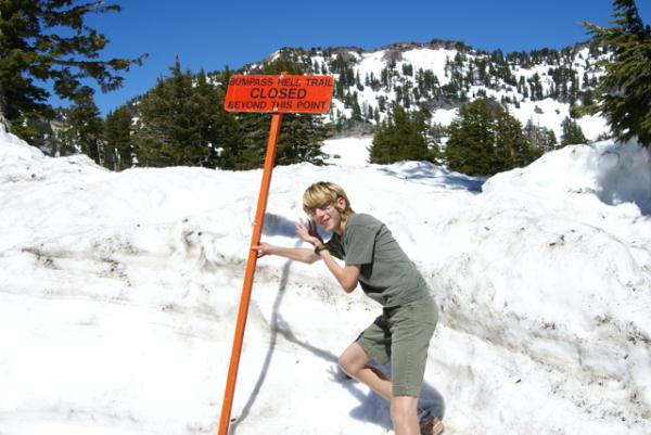 The smell of rotten eggs was prevalent.
The creek rushing downstream was a milk gray color from the sediments and minerals in the surrounding area. I wish Bumpass Hell had been open, as it would have been even more spectacular than what we saw, but I guess this just means we'll have to go back some other time to see it.
As it was, because of the snow, the two earthcaches that we'd planned on getting in the park were also out of the question. The Devil's Breath, was at Bumpass Hell. No way were we going to be able to get out there. I've camped at Lassen several times in the past, even hiked in hip deep snow to get to Bumpass Hell in June right after I graduated from college back in 1981. This time, the snow was overwhelming.
By not being able to drive through the park, we ended up driving completely around the park, something that we had planned for and were prepared to do should it come to that. That actually worked to our advantage, geocaching-wise, since instead of concentrating on those two earthcaches and possibly a couple of caches just outside the southern park border, we ended up getting over a dozen caches on our trip around the park. We gave ourselves several hours inside the park on the south side to view Sulphur Works and drive up to the Lassen Peak trailhead, where the other earthcache, Vulcan's Mecca was located. Once again, we were stopped by the snow from getting to the peak because the trail was closed about halfway up the peak. Next time.
On the drive down from the Lassen Peak parking lot, we stopped at a pullout to get a look at all of the snow. Helen Lake, which is at 8000 feet elevation still had a thin sheen of ice on its surface.  If you didn't know the picture had been taken on July 2nd, you could swear you were in the middle of a clear winter's day. It was amazing to see.
The downside is we missed a couple of caches. There were so many upsides that it didn't matter. The scenery was spectacular and because of our change in itinerary, we ended up finding more geocaches because of it. Probably the best thing of all was our trip a couple of days later over to Whiskeytown National Recreation Area, which is to the west of Lassen.
Last year, when my older son and I drove through the same area in mid July, the lakes were down considerably, showing a bathtub ring which appeared to be fifty to a 100 feet deep. There was no bathtub ring to be seen this year in the lakes. Whiskeytown Lake was filled to capacity, with water right at the vegetation's edge as opposed to 100 feet away. Hopefully, we'll get another couple of good years like this past year, so we don't have to worry about water as much as we've had to in the past. Not enough water isn't a very good thing. This year, at least, we don't have to worry so much about that problem.
Pictures were taken at or near the following geocaches:
The Devil's Breath - by hafhas
Vulcan's Mecca - by Booty Buddies

Monday, July 26, 2010
Cache hiding
In the past, I've dealt with what I think is the most efficient use of my time with regard to the hobby/game/silliness that we all know as geocaching. I've kept a goal for myself of a 1% threshold, where I have hidden at least 1 hide for every 100 I find. I probably could hide more than that, but there's an issue of quality in my mind. I don't hide micros. The smallest container I've ever hidden was a rectangular Altoids container.  The only reason I hid that was as a replacement cache for the one that I accidentally lost in my haste to make the grab. Ooops.
Other than that cache, which really wasn't mine, the smallest has been a decon container. I like decon containers for a number of reasons. The first is they're large enough to hold a small travel bug or any geocoin. In my mind, I think a small should be able to hold at least something other than a log book. A geocoin makes this criteria. The second reason I like decon containers is they're small enough for general placement. I have a couple of decon containers that are hidden just off trails and every time I go out to check on them, they're a tough find. It's embarrassing having a tough time on your own cache. Usually when happens after I check on them is I up the difficulty rating on the cache by half a star or so.
Those and the traditional ammo can are usually my containers of choice for caches, but I've been know to use other things, particularly old coffee containers. B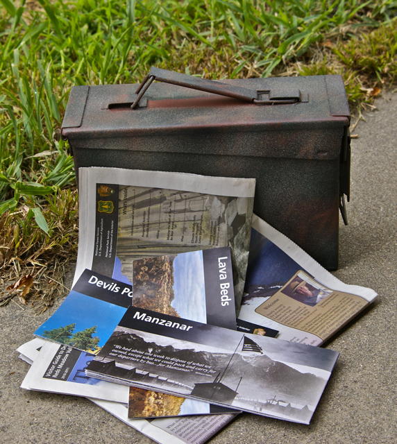 ut that's beside the point I'm trying to make here. It's more background information.
My arbitrary 1% threshold was set by me as a way to keep a balance in my caching. I hid my first two caches after only finding 14 caches. By my own standards, I don't think that's enough cache finds to adequately make a decent hide. There are always exceptions to the rule, but I think had I waited, I might have tried some camouflage techniques on the containers. Neither of the first two containers were camouflaged, just a container with a label on the outside indicating that it's a geocache (see the picture). Not that camouflage is a necessary requirement for a geocache, but I think they would look better if they had. And yet one is still out there after almost 9 years in the field, so i guess it's done OK for a non camoed cache.
The 1% threshold for me keeps me from having too many caches out there at any one time, yet at the same time, it allows me to give back to the caching community. At present I have hidden 35 caches, but only 22 are active. I think if I had more than about 30 caches active at a time, all I would be doing would be cache maintenance. Granted, cache maintenance is part of the game, but it's not the only part. I don't know how people who have 100 or so hides active do it unless they shirk that part of their caching responsibility. Nothing's worse in my opinion than coming across a cache site, not finding a cache and then checking the cache page and finding a string of DNFs dating back several months. That just shows that the cache owner doesn't care about their cache.
What this all really leads to is I'm approaching my 1% again. In the next couple of days, I will end up going over the mini milestone of 3400 cache finds, which will put me within 100 finds of the 1%. I've been working on a couple of hides, so it's now time for me to go out and place a couple more caches. The one I've been working on for the last couple of days is a puzzle cache with a theme to it, only the second time I've themed a cache.
The graphic of national park patches comes from my collection of patches that I've purchased over the years. The Mesa Verde Patch was the very first patch I ever purchased, buying that particular patch back in the summer of 1971. 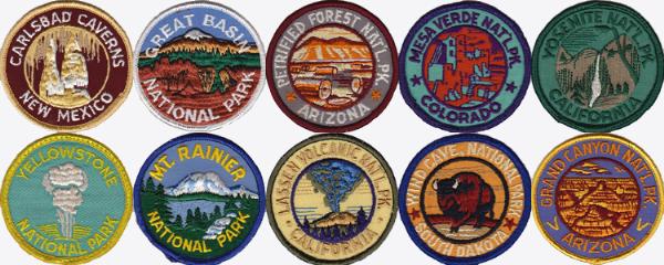 I will be making a graphic for that cache, based on those patches that cache finders will have to de-cypher in order to find the cache. I guess local readers have an advanced warning, but they haven't see the puzzle yet, so it's really not a head start for them.
I hope to have this one out by the end of the week. Today would have been a good day to go out and hide it, since it was unseasonably cool this morning, but I had no energy this morning due to a migraine. If the weather continues in this vein, I might get out tomorrow or Wednesday to hide it. I'm hoping this one will be challenging for cachers.
Top picture was taken the following geocache:
Willow Creek Cache - by The Swamp Things

Friday, July 23, 2010
Hot Rock
One of the things about camping at higher elevations is the differences in weather that we're normally used to experience at our regular altitude. 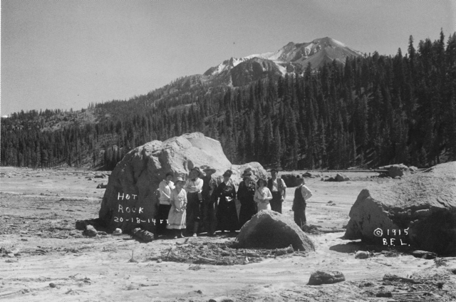 Before our camping trip, I had received an email from Chaosmanor asking what I was going to do about Lassen Volcanic National Park? I didn't know what the heck he was talking about, so I started investigating and discovered that the park road was still closed due to the high volume of snow.
I could postpone our trip, but I'm not sure if that was going to accomplish anything, so I decided to keep out timetable and leave when we had planned to leave. If there was snow, that would just add to the adventure. Besides, we had planned to meet Chaosmanor up at the GPS Maze exhibit on the 5th of July. If I postponed our trip, that visit wouldn't happen. It was something to consider, but for the most part, I didn't seriously think too long about postponing the trip. The snow could be fun.
The day we got to Lassen, we headed down the park road, which was cleared for about 10 miles into the park. The drive took us to several locations, one of which is interesting from the standpoint that we could get a feel for what Mt. St. Helens might look like in 70 years or so. Mt. Lassen erupted almost 100 years ago and today, it is a living laboratory. It's about 70 years ahead of Mt. St. Helens, which is a similar type of volcano, being in the same Cascade range.
Along the road, we stopped at the Hot Rock, a very large boulder that had been ejected from Mt. Lassen and come to rest approximately 5 miles away from where it had started in the mountain. I scanned a postcard that I purchased at the visitors center showing the rock only days after it had been ejected from the mountain. 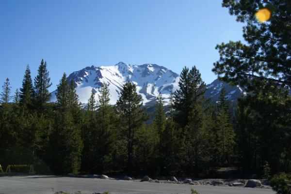 B. F. Loomis, a photographer had taken this photograph and had noted that the rock had glowed red hot for several days after it had made its final resting spot. Loomis' photos are a great historical record of the area, which can be compared with similar views today. The rock as noted on the postcard, was 20x18x14 feet, a massive rock. Today, it stands by the side of the park road, with no view of the mountain any more.
There is another area just down the road from the Hot Rock known as the Devastated Area. It has a similar view to the Hot Rock postcard picture. In the postcard, the ridge of trees to the right were spared, because of the local topography. The heat, volcanic winds and mud and landslides from that major eruption swept around or over the ridge sparing many of those trees. However, the other area to the left is clearly barren of any kind of plant life. That is what was called the Devastated Area. Compare that with the picture I took at the Devastated Area. Nature has a way of reclaiming its own eventually. This is a glimpse of what Mt. St. Helens could look like in the future.
Pictures were taken near the geocache:
Loomis - by 2dogs and mtnsteve

Wednesday, July 21, 2010
Rainbow Falls
A friend of mine, who I introduced to geocaching, described geocaching as "Hiking with a purpose." I would respectfully have to disagree with him. I guess it's probably because I grew up with camping and hiking. My first camping trip (to Yosemite National Park) was with my parents when I was four years old. Everywhere we camped, we hiked. If you didn't want to hike, you stayed in camp, unless Mom decided to go on a hike too, which was many the time, so we learned to hike.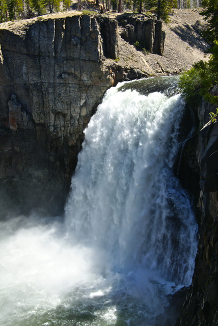
When we go camping today, we hike. If it weren't for geocaching, we'd still hike, but I think geocaching has expanded those hikes to new and different places. As a travel enthusiast, I like to take new roads when I go somewhere. Driving the same road, back and forth to the same locale isn't what I'd like to do, although I know people who enjoy that. It's just not for me.
That's probably why we end up going to so many different spots when we camp. Camping in the same place is OK, but different locales afford us new and different experiences. And, obviously, it also gives us more chances to geocache. The hiking aspect of geocaching comes into play, but it's not the reason we geocache, nor is geocaching the reason we hike. We hike, because we like to be outdoors. I like to watch the scenery go by.
When we hiked to Rainbow Falls south of Devils Postpile, we took the shuttle bus from our campground to the trail head. We could have just hiked from the campground up and back, but that would have been the same route. We also had other things to accomplish that day, so by taking the shuttle to the trail head, it shortened what would have been a five mile round trip hike into a 3.8 mile hike. It was still a significant hike, but a little less strenuous and thus gave our legs a little more energy for later in the day.
The hike down to the falls took us through a major burn area from a lightning strike fire that started at the southern end of the park and burned through a major part of the park in 1992. The area, almost 20 years beyond that fire still shows the scars but is slowly rebounding. There were many old snags standing as sentinels over the landscape and just as many fallen trees. We could see evidence on the downed logs of recent bear activity as the bears looked for grubs and termites in their quest for food. The animals were helping with the decomposition, which was further enhancing the soil, allowing the new growth of plants to flourish.
The falls were spectacular and we got there at a good time. The sun was overhead and because of the large amount of water in the San Joaquin River, the water was plunging over the 101 foot precipice at a high rate, causing a lot of mist to spray up at the bottom, creating the signature rainbow for which the falls are named. Actually, if you look closely in one of the pictures, you'll see a double rainbow.

Afterwards, we hiked down to the lower falls, a smaller waterfall further down the trail and outside the park boundary. Apparently, there were only two other people who took advantage of that trail while we were there, because we saw them at the brink of the lower falls. We didn't see anyone else on that portion of the trail the entire time we were on it. Alone in the wilderness.
The return trip was via the main trail that runs along the eastern edge of the park from the falls back to the postpile and beyond to the campground at the northern end of the park. While on that trail, I kept watching the mountains to the west of me. Trees would obscure them for awhile and then allow me different glimpses of them further down the trail. I kept watching this one ridge as it slowly blocked the view. Eventually I had to stop and take a couple of pictures, otherwise I figured I might lose the view entirely.
Every time I stopped, it seemed like there was another group of hikers heading out to the falls. The trail is very level, and thus, a very easy trail for all age groups, even if it is 2.5 miles long one way. I would think that most people could do this trail, even if they weren't in the best of shape. It would be a good workout for those not in tip top shape and a stroll in the park for those that were. I probably fit into the former as opposed to the latter.
The common question I ended up getting by most of the groups was "How much farther are the falls?" Since I had an earthcache at the falls in my GPSr, I was able to give them "crow fly" mileage at least, but since the trail went relatively straight to the falls at that point, the GPSr mileage wasn't that far off.
 The interactions with other hikers were pleasant and didn't detract from the overall experience I had on the trail.
 It was a great hike. And yes, there was an earthcache at the falls location. Did we hike out there to get the earthcache? Yes we did. But I think the more important question is, would we have hiked out there had there not been an earthcache out there? Yes we would. As President Kennedy stated in a speech in 1961, "And they may well ask why climb the highest mountain? Why, 35 years ago, fly the Atlantic? Why does Rice play Texas?" The answer is self evident. In reality, I don't feel geocaching is hiking with a purpose. I think, rather, it's another reason to get out and hike.
Pictures were taken at or near the following geocache:
Rainbow Falls - Devil’s Postpile NM - by TerryDad2

Monday, July 19, 2010
Underrated
One of America's Best Ideas has been the creation of National Parks. It started with Abraham Lincoln, back in the 1860s when he signed legislation protecting parts of Yosemite Valley and continued into the 1870s when Yellowstone National Park was created by congressional act. 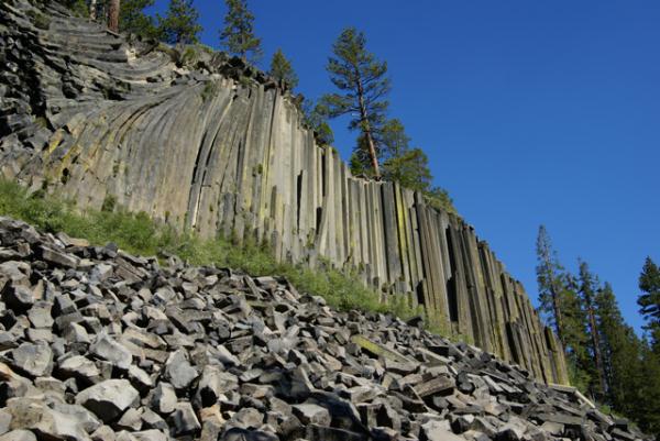 In 1906, Congress passed the Antiquities Act of 1906, which allowed presidents the power to set aside tracts of land as national monuments, kind of a step lower than a national park, which can only be created by an act of Congress. Today, there are national parks all around the world protecting areas of scientific interest, or scenic beauty for generations to come.
Many of the first National Monuments have been later created into National Parks, such as Katmai National Park in Alaska and Grand Canyon National Park in Arizona. Presidents Wilson and Theodore Roosevelt had the foresight to originally protect these areas until Congress got around to finishing the job. The National Park Service was created in 1916 and administers many more units than just the 58 national parks in the United States.
There are still many national monuments scattered around the United States and the Tadpole and I were fortunate to visit two of them on our latest camping trip, Devils Postpile and Lava Beds. Coupled with Lassen Volcanic National Park, which we also visited, there was a definite theme to what we saw on this latest trip. My point for all this history is I believe that many national monuments are neglected by the general populace, because they aren't national parks, they aren't the best of what America has to offer.
To this I say that most of the national monuments I've visited in my lifetime are vastly underrated. They usually are smaller than a typical national park, but have many of the scenic vistas one comes to expect at a national park, but with usually no crowds to speak of. On a hike out to Rainbow Falls in Devils Postpile National Monument, we encountered the usual number of hikers who were willing to take the fairly easy 2.5 mile hike out to the falls. 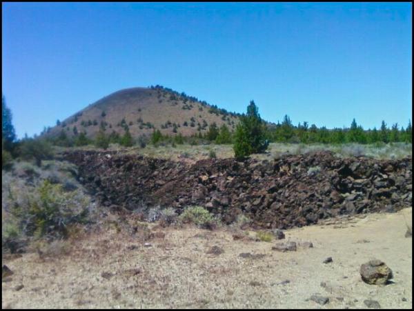 However, once there, they took their pictures, and then made the return trek. There were many times when we had the views all to ourselves.
Many times, while hiking in a national park, we've encountered other hikers, but there was no practical way of getting away from them, mainly because there were so many hikers. In Devils Postpile, all we had to do is wait a couple of minutes, and we had the place to ourselves again. We took the slower route to many areas of the park and enjoyed the solitude the park had to offer to us.
The same could be said for Lava Beds National Monument. The park preserves multiple lava tubes, historical areas and beautiful landscapes we have come to expect from these kinds of areas. The small campsites at both places were clean and never filled. Contrast that to many national park areas where you have to get camping reservations 6 months in advance and there's no chance of having the campsite next to you empty.
Another enjoyable aspect of visiting national monuments is most people have gone out of there way to visit these areas, probably because they have an interest in what the monument is offering. Many times, you'll find like minded people that you can share an experience with, that might not happen in a national park, because of the many tourists who are there, to enjoy, but not necessarily immerse themselves.
We had an enjoyable evening with an older couple taking their youngest granddaughter on her first camping trip in Devils Postpile. We watched as two young men came into the campground and picked out a campsite. 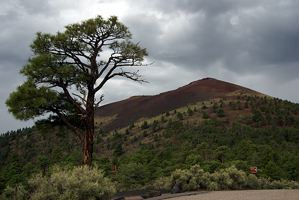 I made a comment that I believed that these two young men were probably either walking the Pacific Crest Trail or the John Muir Trail based upon their backpacks. Sure enough that had been walking for the past five days from Toulomne Meadows in Yosemite National Park to the Postpile, a distance of 34 miles. That doesn't seem like they were walking very quickly, but the snow had slowed them down tremendously over many of the mountain passes.
I would not have been able to enjoy their stories had we avoided Devils Postpile. It's on the route of both of those long range trails. You don't encounter backpackers on the trail that often in many of the national parks, because they're walking through remote regions of those parks. With the national monuments, many times the monument is the remote region.
The experiences I've shared in national parks and monuments have both been enjoyable and enriching. I just think the national monuments are underused treasures of the national park system. They are truly underrated. But, let's keep that our little secret. We don't want them to get too crowded.
Pictures were taken at or near the following geocaches:
Devils Postpile National Monument - by truckgirl2
Skull Cache (Lava Beds National Monument) - by ChrissySkyking + Blaze
Cinder Hills Overlook (Sunset Crater Volcano National Monument) - by TerryDad2

Friday, July 16, 2010
A tree grows in Brooklyn
Well, the tree doesn't really grow in Brooklyn, but actually grows on the top of Devils Postpile. The first time I was at Devils Postpile, we climbed up to the top of the postpile.  It's like being on top of a large patio terrace in someone's back yard, with the major difference being if you take a wrong step, you're falling a long way.
10 years ago, I took all three kids camping in Yosemite National Park. On one of our hikes, we hiked up to the top of Vernal Fall. The hike is strenuous, with lots of stair steps rocks to negotiate. There is a guardrail along that part of the trail, and once you get to the top, the guardrail had a screen wire grate along the bottom portion of the rail to prevent anyone from slipping out and falling over the waterfall. The viewpoint is right on the edge of the waterfall as you can see by the picture.
The Tadpole, at the time was four years old and when we climbed to the top of the fall, he dutifully held my hand, mainly for safety, but also because he wanted to feel the support of Dad as he made his ascent. It was at the top when all hell almost broke loose. In every parent's worst nightmare, he broke free of my hand, just as we crested the trail and the viewpoint. I hadn't seen the wire mesh grate, but even if I had, I probably would have freaked a little bit. Because I didn't see the wire mesh, needless to say I freaked a lot. Suffice to say, nothing happened that day and the Tadpole is still around, as am I.
One of the things I noticed about the Tadpole on this past trip was his willingness to just take over things that I normally did when we camped. He decided to be in charge of the food storage box. In California, most campgrounds in bear country are outfitted with metal storage lockers to prevent bears from raiding your supplies and also to keep bears away from populated areas. Bears that feed on people food, as opposed to what they're supposed to be eating isn't good for either bears or people.  The Tadpole decided that the storage box was his territory on this trip. He organized it, he got the supplies out when it was time to cook dinner, and he put the supplies away at the end of the meal. It was nice to not have to do everything this time around.
I think I might have been more nervous on the top of Devils Postpile back then had we gone there. There is no guardrail and not anything to remind people of a steep drop. Everyone knows it's there. I didn't even think twice about walking around up there nor did I worry about the Tadpole. His maturity, at almost 15 now, is showing big time and he's turning into that responsible young man that we all hope our sons turn into when they reach that age.
One of the things that I wanted to show the Tadpole at the top was a small tree. I'd photographed this tree back in 1977. As you may have noticed if you're a regular reader, I enjoy seeing the struggles of like, especially when plants grow where you don't think they should grow. The tree that used to grow on the top of Sentinel Dome is one good example. When I took that photo, I figured this tree might be something along that line and I hoped that someday I might get back to see it. As you can see, the tree hasn't grown much. By comparing the two pictures, I think it's safe to say there's about a foot of growth on the tree.
I guess I was overly optimistic when we came back this summer. I think I was expecting the tree to be several feet higher. After all, it had 33 years in which to grow. I forgot about where it was growing.  It had two major disadvantages going against it. The first, and probably the most important was the fact that it was growing in very shallow soil. There were a lot of nutrients at the top of the postpile and so it's growth would probably be microscopic. Because it's so readily accessible during the summer months, I'm sure it gets beaten around by all the people that make the short trek to the top of the postpile as well.
Still, the tree had grown a little and that was promising. It also showed, that it would be a long time before this little tree towered over anything else in the forest. It has its foothold. Now, hopefully, it will continue to send down roots and continue to thrive. The Jeffrey pine tree on the top of Sentinel Dome is no more, but it lived a good long life and never got more than about 12 feet tall at best. The living conditions up there were probably harsher. I have hopes for this little tree.
Pictures were taken at or near the following geocaches:
Mist Trail Cache - by V-man
Devils Postpile Glacial Polish - by TerryDad2

Monday, July 12, 2010
Earthcaches Galore
Our trip along the eastern side of the Sierra Nevada culminated in our camping at Devils Postpile National Monument. This monument, established in 1911, preserves an interesting basaltic columnar formation and an impressive 101 foot waterfall, aptly named Rainbow Falls.
Since the monument is part of the National Park Service, no container type caches can be placed in it, but virtuals (if they were already created) and earthcaches can be. 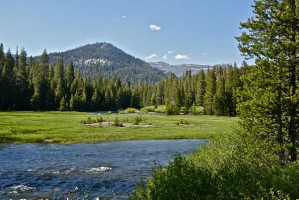 Earthcaches are a geological discovery. You learn from the cache page about a particular aspect of geology, answer some questions, based upon your observations at the cache site and thus, get credit for a cache find. It's the new type of virtual cache that Geocaching allows on its site.
In the park, we found four earthcaches, two on the first day and then two more the next day. We split them up only for convenience's sake. We could have done three on the first day, but the fourth required a substantial hike, so it was basically unavailable the first day of our camping trip.
One of the earthcaches we did on the first day was the Soda Springs earthcache. I'd been here in 1977 as part of a biology summer school class I'd taken at my local community college. Devils Postpile was one of the places we'd stopped to visit and I can remember our instructor, Dr. Bates, talking to us about the Soda Springs in the area. In August, the San Joaquin River, which runs through this glaciated valley is at a low point, with most of the winter snow melted at this point, so there isn't as much water movement where the springs are and so we could see lots of iron oxide precipitate deposited along the shoreline where the springs were.
We had a very heavy winter in the Sierra this year and even in late June, the runoff was tremendous. The San Joaquin was very close to flooding in areas. 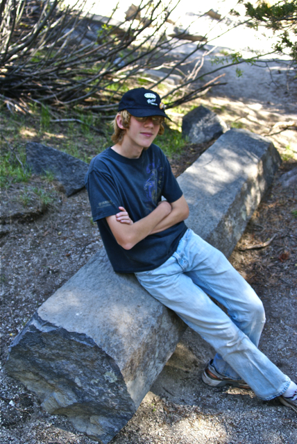 The meadows were very wet and boggy due to excess water - mosquitoes were rampant. Because the river was so high and swift moving, the iron oxide precipitate was non-existent here. It was fun to explain to the Tadpole the differences between the two time periods and why things were the way they were.
Other things we investigated while in the park were the direction the glacier moved through the park while it was polishing the top of and plucking the face of the postpile. The postpile is a series of basaltic columns that cooled a relatively even time frame. When the last ice age glacier scoured the area, the postpile was exposed for all to see. Over time, columns have eroded and fallen to the base, creating the postpile. The columns are generally smooth on the top where the glacier ground against them.
They are also large in size. At first glance, you can't really appreciate the size of the columns, but you have ample opportunities to get very close to some of the fallen columns and it's then you can truly appreciate how big they are. Earthcaches aren't for everyone, but as the Tadpole likes to say, "you get to learn something with these, so I like them." They take more time to do and so, they're not conducive to "numbers" runs, but then again, it's not really about the numbers, but the experience. You truly get to experience the surroundings with earthcaches.
Pictures were taken at or near the following earthcaches:
Soda Springs at Devils Postpile - by TerryDad2
Devils Postpile National Monument - by truckgirl2

Friday, July 9, 2010
Owens Valley
The Tadpole and I just got back on Wednesday from one of our more satisfying camping trips in a couple of years. Camping trips in general seem to be fraught with could'ves and should'ves. This one didn't have that feel at all, with a couple of minor exceptions. We did what we wanted to do and only once, really got caught up in the, "No, we can't do that cache because we have to be somewhere else" mode.
That is a good thing in my opinion.  There were lots of things to do, lots of things to explore and we both had a really good time. Our first day out was, obviously, a driving day. We managed to get a virtual flag near Red Mountain and about five caches on the drive up, including a couple after we established camp at Devils Postpile.
As we drove north we kept a look out for interesting things to see. I wanted to make sure my son got to see Mt. Whitney. We talked about the John Muir Trail that stretches from Whitney's peak to Yosemite Valley. We ended up walking along part of the trail while in Devils Postpile later in the day.
Once you get into the Owens Valley part of California, the scenery pretty much speaks for itself. Owens Valley is on the eastern side of the Sierra Nevada and sits around 4000 feet of elevation. Directly to the west sit the Sierra Nevada, towering over the valley. At points there is a quick elevation gain of nearly 10,000 feet between the valley and the mountains.
The mountains, created by a fault block were uplifted and create a major rain shadow. Owens Valley is in the rain shadow and doesn't get much rainfall over the course of a given year, because the mountains trap the moisture from the clouds as they rise to go over them. This year was a particularly wet winter and there was a lot of snow in the high mountain passes and peaks. So much so that it would affect our camping trip down the road.
One spot we chose to stop was at Manzanar National Historic Site. Manzanar was one of several relocation centers for Japanese Americans during World War II. Many Japanese Americans were rounded up during the early stages of the war and sent to live in these relocations centers for, as the government put it at the time, "the safety of the Japanese people." Ironic that the guard towers posted at these relocation centers had their guns pointed inward as opposed to outward to protect from an external threat to the Japanese American people living there.
After touring the newly created visitors center at the old gymnasium, we were back on the road again, heading toward Devils Tower. We stopped for one more cache north of Manzanar and reveled in the beauty of the cache location. The disparity between the two locations was striking.  Manzanar was a harsh and unforgiving place back then and is still, for the most part the same today. The National Park Service is slowly recreating it so that the visitor's experience will reflect the day to day life the Japanese Americans had during that time period.
Sixty miles to the north, the beauty of the place overwhelmed us, much like the starkness of Manzanar tried to do earlier. This time, we let it.
Pictures were taken at or near the following geocaches:
Manzanar Virtual Cache - by GoodDogSD
Cache with a View - by Rallye