I was looking over some of the travel bug pictures I've taken recently and I've noticed I've fallen into a similar trap about which I've previously written. 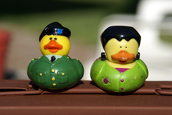 It's either I don't have the energy, or don't have the imagination to come up with a good picture for every traveler that I grab. I have noticed that it's easier to take pictures of travel bugs as opposed to geocoins. So I'll do what I can, when I can.
Of the recent pictures, I particularly like the one I took of two similar travel bugs, Sgt. Ducky and Frankenduck. Both ducks/travel bugs were found this summer while caching and both went north on our aborted camping trip. I was able this past week to deposit Sgt. Ducky in my latest cache, 360. Frankenduck will end up in a cache, hopefully, this weekend. The ammo can they're sitting on is planned to be a hybrid letterbox cache in the near future.
The second picture in this article is of Nurtz. I picked up Nurtz down in San Diego County in late July and put slightly more than 700 miles on it, but really didn't get it much closer to its goal. 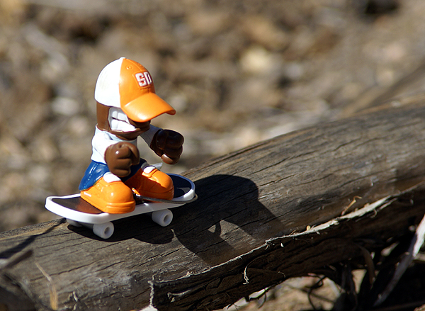 That's sometimes the way it is with travel bugs. He also came with me north on the camping trip, but I wasn't able to drop him off in a cache up there, so back he came and I ended up placing him in a fairly large cache out in the Antelope Valley just north of me. It looks like the cacher who just picked him up will be taking him closer to his goal, so that's a good thing.
I need to order some more decon containers. I have plans to set up my second multi-cache near 360. Cachers will have to "explore their technology" a little bit, utilizing various features of their GPSr they might not have tried in the past. I think it will be a fun little cache to solve and find.
Last, but certainly not least, the plans are to go caching this weekend on two of the three days. Chaosmanor and I will be caching up in the local mountains, hopefully to escape some of the heat that we've been getting as summer does its typical heat up in late August and early September in Southern California. It shouldn't be as hot at altitude as it is down in the semi-desert which will be a good thing.
I'm hoping the Tadpole wants to go caching on Monday. There are some caches that I'd like to look for down near the beach in Orange County. Monday also happens to be his 13th birthday, so I'll play a wait and see game on that. If he wants to do other things, then that's what will happen that day. It's his day after all. I can remember when he was born thinking that when he became a teenager, I would be the father of three teenagers all at the same time and shuddered to think about what that might entail. It was easy to brush off at that time, since it was so far in the future. Well, the future is here. It's amazing how quickly the time passes.
Pictures were taken at or near the following geocaches:
360 - by Webfoot
Christmas Cookies? - by Searching Gentiles
Spirit In The Sky (AKA Grievous Angel) - by FunHog
Wednesday, August 27, 2008
Bits & Pieces, Odds & Ends

Friday, August 22, 2008
Slowdown
I went back to work today, spending most of the morning in teacher meetings. It was a good day overall as I got my room ready for students to come back to school next Monday. For whatever reason, the months of September and October have traditionally become my "slowdown" months for caching.  Because I'm off in the summer, I tend to find a lot more caches during that time as opposed to other times of the year. If I were a betting man, I would have bet that I've found more caches in August than in July, but the graph proves me wrong.
What I have noticed over time is the big drop off in September and October. With the exceptions of those two months, I've found at least 115 caches in every other month. I know I don't have any holidays during those months, but neither do I have holidays in February, yet the numbers for that month are high in comparison. I suspect that I'm in the "let's make sure that everything is running smoothly" mode at the start of a school year and I don't have time for much caching. In my opinion, that's a good thing. Starting out the first of the year on a good note is a good thing for a smoothly running classroom. As the year progresses, I have more time for extra curricular activity because the classes are running smoothly by that time. It takes time and effort to do this, so I'll not quibble that the numbers are like that. What it also might mean is I might not have as much time to post in here as well. We'll see what happens over the course of the next two months.
Graph was taken from stats generated from INATN.

Wednesday, August 20, 2008
Melancholy Road Trip
This past Sunday through Tuesday I was on a road trip. Knowing me, road trips cannot be a sad time, yet this one was a little bit, since  I was, once again, taking my daughter back up to college for another year of education. The trip up was rather uneventful. Musicmaker drove half the way and I was amazed at how refreshed I was after 6 hours of driving. Usually, I'm beat, but the extra driver made all the difference in the world. I can remember driving 12 straight hours to get to my college and being as fresh as a daisy after the trip. I guess that's one of the prices we pay for getting older.
We found four caches on Sunday, plus a virtual United States flag just west of Visalia. The PQ I'd run for this trip was heavy into larger sized caches because I had a dozen travel bugs that I wanted to distribute. Micros don't work well when you're dealing with travel bugs although I did find a micro on Monday that was large enough to hold a small travel bug. One cache was a virtual near the old city courthouse in Merced, CA but in all of the other caches we found, we dropped travel bugs. My daughter even found one of the caches. Now she would be the first to admit that she's not much of a cacher. She says she likes the idea, but doesn't have enough time to go out and look for them. But she was very excited when she spotted Preferred Cache and every time we mentioned to others on this trip we went caching, she made sure it was known that SHE found that cache.
Monday morning was devoted to unpacking the van. Why is it when ever you're moving someone, that person always has the room that is farthest from the staircase and is on the third floor of the building? 11 trips later, we had the van unpacked. My work was done. So I just sat in her room and logged my caches from Sunday while she unpacked all of her boxes and made her room a home. After lunch, I went caching while she decided that she needed to hang out with some friends.
The caching on Monday was very good. I found several large ammo cans in which I deposited more travel bugs and I also nabbed two more virtual flags, getting Argentina in the back yard of a farm near Wilton, CA and the red and white banner of Canada which was virtually placed on the top of a red and white storage shed in the garden center of a nearby 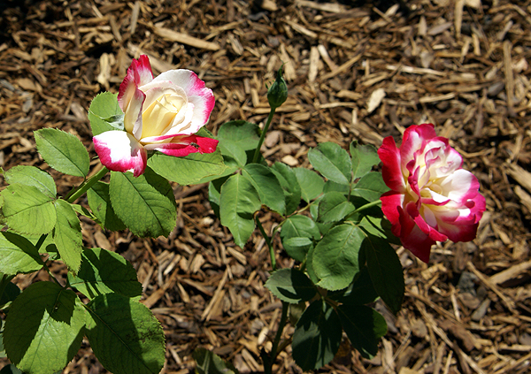 Lowe's hardware store in east Stockton. The virtual cache near the Wilton post office was a very moving experience for me, being a memorial of rose bushes set up by people living in the area. The entire garden was full and could take no more bushes. I sought out a particular rose bush that had been planted in memory of the Unknown Soldier and took a picture of it for posting in my log.
Tuesday, it was time to start my travels home. I woke up, showered, went to breakfast, then dropped by her room again, said good bye to her and went back to my hotel, packed and drove home. Although we view this house as home, it dawned on me yesterday that Pacific is her home. She was in her element there and it was really fun to see the change from last year where she really clung to us and hung back, not wanting to get too far away from either of us during parent/student orientation. T his year, it was, "See ya, Dad." Not as blunt as that, but it was really good to see her reuniting with all of her friends again, screaming and yelling when they spotted each other and hugging each other. I could have dropped her off on Monday and probably have gone home then, but it would have exhausted me. Not that she didn't enjoy my company and I hers, but it's different this year. A good different, but still different.
So the trip home was sad, but I enjoyed the solitude. The caching was enjoyable Tuesday as well. I chose a different route going home because there were a couple of dash points that I wanted to get, so I took Hwy 99 for the first leg, but diverted to Hwy 41 south of Fresno, connecting eventually back up with Interstate 5 at Kettleman City. I got the two dashpoints plus some more caches along this route. It was a good day to be alone with my thoughts as I pondered what it will be like next year, when I help two kids off to college. I listened to a CD that she burned of oldies and some of her music on the ride.  When I hear any of those songs on the radio in the future, I will remember this trip.
Pictures were taken at or near the following geocaches:
Fig Tree View - by Oldhippy & Granny
A Walk to Remember - by George and Mary
Wilton Memorial Rose Garden - by DiaU
Red & Green's Travel Bug Hotel - by Delawares Blue Hen Chicken
The Grangeville Zoo - by Great Scott!

Friday, August 15, 2008
Math and GPSrs
A couple of days ago, I took the Tadpole and went out to find a couple of flags for GeoVexilla. As luck would have it, there were three caches near one of the flags so we attempted to get those as well. We found a 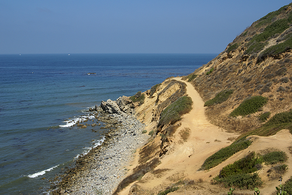 Saint Pierre and Miquelon flag which was the first flag that was worth 16 points for me as it completed my first flag set. That one was found in Inglewood, CA very near the Fabulous Forum where the Los Angeles Lakers and the Los Angeles Kings used to play their home games until the Staples Center was built in downtown L.A.
The next flag was a Uzbekistan banner located on a bluff overlooking the Pacific Ocean in Palos Verdes Estates. Most of the homes in this area ranged from $5 million to probably way over $10 million dollars even in today's depressed economy. Getting this banner looked to be pretty straightforward based upon the Google maps and satellite images. Once we got to the bluff, I realized that I might have a dilemma on my hands. I was within 325 feet (256 feet to be exact) distance horizontally from the banner, but the problem was the banner was not directly horizontal away from me, but down the bluff toward the ocean. Now, do I need to be at least 325 feet vertically as well? I hadn't run across this before on the site and I've since found that once you're within scoring distance, it doesn't matter whether you're vertically ok, as long as the GPSr says you're within scoring distance, you score the points.
I didn't know this, so I attempted to get closer. We could see a trail down along the ocean, so we went in search of the trail head to get down there. 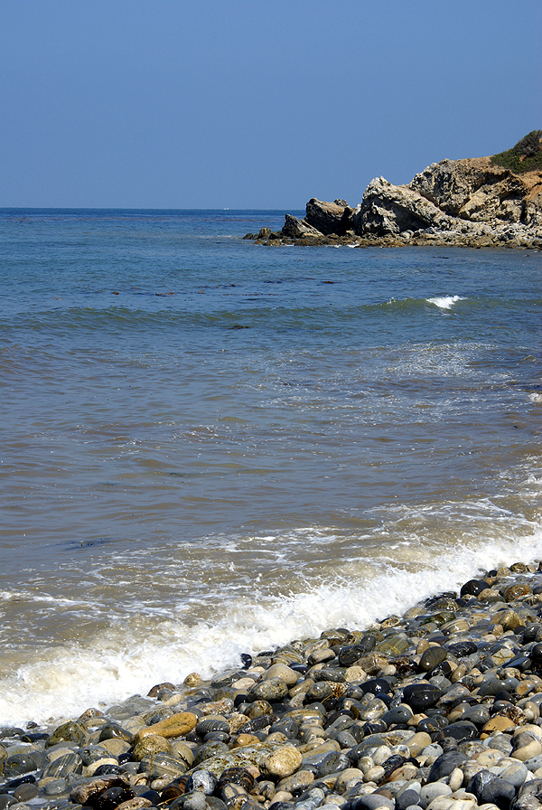 The trail head was only about a quarter mile away, so that worked out well. We also noticed a well concealed cache at the trail head, which we found first before heading down the trail. Just as we were replacing the cache, five or six brown pelicans riding the thermals, came soaring up the face of the bluff at that point and appeared right in front of us about 30 feet away. I wasn't quick enough with the camera to get a picture of these but the site was very impressive. The Tadpole let out an audible, "Whoa," as they came up and over us. It's probably one of those encounters that he will not soon forget. After replacing the cache in its hiding spot, we headed down the trail to the Pacific Ocean.
The trail became one of those teachable moments while we were looking for a way to get closer to the Uzbekistan flag as well as two other caches that were located down there. I noticed the beach was very narrow at this point, and not knowing the tide schedule, I made sure that he never put his back to the ocean while we were on the beach in case a rogue wave came or the tide starting coming in. Once down on the bluff, we found another trail that took us further up the bluff and closer to the flag. We were able to get 178 feet away from the flag at that point while being 34 feet above sea level (the bluff above was 297 feet above sea level). That was our closest approach to that flag, so I figured that I'd rely on my mathematical abilities at home to see if I would score.
We then proceeded to look for a very nicely camoed ammo can along the bluff plus a virtual cache located down there, finding both. There was a memorial bench to a surfer who had died and had his ashes scattered down in that cove which the Tadpole used to contemplate the ocean for several minutes before 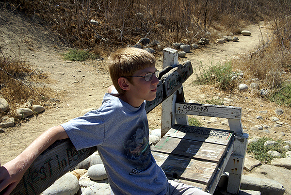 we decided to make our way back up the bluff to the car. Of course, being the 12 year old, he also insisted on throwing a couple of rocks into the ocean as well. I had forbidden him from doing that earlier up on the trail, due to the possibility of hitting someone down below that we couldn't see, another one of those teachable moments we seem to get all the time.
Once home, after a slight detour to get the last flag, I set down to figure out the math for the Uzbekistan flag. It was more mental exercise than anything else, since I figured that I was about 100 feet or so away from the flag from the lower end, just looking up the slope, but I wanted to make sure. Working out a drawing, I calculated the vertical and horizontal distance of my triangle, but I needed the hypotenuse of the triangle, which would be the line leading from the bottom point up the bluff to the top of the bluff where we had been standing previously. I found a site that helped me out with some of the math, since I'm a little rusty, having not done this type of math since probably college. When the calculations were done, I found that the flag/point I was looking for was 102 feet higher than me when we were down at the bottom and 154 at the top. The hypotenuse of the triangle yielded distances of 308 from the top and 205 from the bottom, both were within scoring distance, so I was good.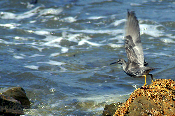 In reality, the distances were actually closer than either of those last two figures since the bluff wasn't shaped like a triangle, but more like a parabolic curve. That would change the distances from me to the flag, but would actually decrease the distances, so I was definitely good for scoring. As I noted above, I found out later that I didn't have to do all the math because I'd already scored, but it was a fun exercise anyway to figure it out.
The day turned out quite pleasant down at the ocean. The Tadpole and I got a good hike in, we found three flags and three caches while on the hike, got to see some nice scenery and the Tadpole learned a couple of safety considerations. Not a bad day at all.
Pictures were taken at or near the following geocaches:
View to a Thrill - by seaglasspirates
Surf Refuge - by Windzombie
Flat Rock View - by Jonaz

Monday, August 11, 2008
Discrepencies
It's interesting how different GPS units measure the same information. This past Saturday, my friend Chaosmanor and I went out  Geocaching, Geodashing and capturing some flags as well. It was a fun day, with a lot of variety in it. I guess you could say it was the balm that made missing the camping trip a little bit better.
The first dashpoint we attempted, our GPSrs were agreeing with each other almost down to the smallest detail. The picture of our two GPSrs are each pointing at the rock in the center between the two. When they were placed down, they both read zero. After we had taken our pictures and notes, we looked at the GPSrs and they were both pointing at the rock and registering 1 foot away.
Surprisingly, later in the day, at our last dashpoint, the closest we could get to one another while trying to zero out on the point was about 25 feet. We've noticed similar things on other caching trips we've taken, but usually it's a difference between makes, the old Garmin vs. Magellan type of thing. Saturday's discrepancy was between different models of Garmins. I have a eTrex Legend C and his, I believe is a 60 Cx. I haven't talked with him yet, but I also waymarked another water tower near the dashpoint we got early in the day. He also took readings but I'm not sure how they compare to mine for accuracy. With the hand held models, I wouldn't expect the greatest accuracy, but I found the difference as we went through the day curious.
Pictures were taken out in the Antelope Valley near dashpoints:
GD86-AKAP
GD86-AKOR

Wednesday, August 6, 2008
Best laid plans
"The best laid plans of mice and men often go awry." This line, adapted from To a Mouse by Robert Burns best describes our camping trip. Yes, we're home already. Monday morning broke cloudy and humid as the monsoon season that we so typically get in Southern  California seemed to have arrive. I thought to myself as I went to get the paper, great, we'll be getting out of this and moving to a little bit cooler climes. We ate our breakfast, gathered up our last minute incidentals that still needed to be in the car, said our goodbyes and were on the road before 8:15 in the morning. We encountered some traffic along the 210, so we decided that we would forgo our first Vexillum flag of Haiti that was located in the San Fernando Valley and just headed off toward the Grapevine.
The rest of the drive up the I-5 was rather uneventful, although there were clues to what lay ahead. For lunch, my wife had prepared a nice sandwich for each of us. The tadpole took about three bites of his sandwich and about two sips from his juice can. I should have thought about that since he's starting to eat like a horse, but I've seen other trips where he doesn't eat much on that first lunch, so I really didn't think much about it.
After crossing over to the coastal valleys via Hwy 152, we reached our first waypoint, another Vexilla flag, this time of Barbados. The farm land was typical for the area around Gilroay and Hollister, alternating with groves of trees, most likely almonds, with corn and then pasture lands for cattle. The flag we were seeking happened to be located in a cattle pastureland. We couldn't go all the way to ground zero, but we were close enough to score the point for the flag. Being close to Gilroy, which bills itself as the "Garlic Capital of the World," we couldn't help but notice the pervasive smell of garlic in the air. However, even my son, who loves garlic, balked at the advertisement on the famer's market stand on the road which advertised Garlic Ice Cream.
We then made our way north along Hwy 101 towards San Mateo County. Once entereing San Mateo County we started actively looking at the GPSr to find a cache that we could find and log. We eventually found a very nice ammo can on a ridge overlooking I-280 on one side and the San Andreas fault zone on the other side. We then got back on the freeway and made our way to the very next exit which was a rest stop. As I got out of the van , I noticed another cache here, so we found that virtual as well, learning a couple of nice things about some of the missions in California.
Then we headed up to San Francisco, getting a dashpoint near the San Francisco zoo and a virtual in the heart of the city. The city's finest elements appeared in all there glory while on this trip through the city and the Tadpole marveled at the different kinds of people there were in the world. In a car in front of us at one point, there was a passenger who had, at minimum, an 8 inch Mohawk hairstyle. I'm not sure either one of us were ever able to determine whether this said individual was male or female. Not that it mattered, it just added to the overall story.
San Francisco was living up to its reputation weatherwise, being very cold and cloudy. The tops of the highest skyscrapers were shrouded in fog as were the tops of bother towers of the Golden Gate Bridge, yet you could look across the bay and see Alcatraz Island, basking in sunlight. We continued north, making a turn at Hwy 1 to get out to the coast on the Marin County side of the Golden Gate. That's when I started noticing more problems.
The Tapdpole, who rarely gets headaches had one and was rather pale. When we got to camp, he perked up a little bit and I attributed it to the winding road and a little car sickness. After a hearty dinner, which he wolfed down and setting up camp, we decided to try and find our first cache in Marin County. The closest one to our campground, we ended up not finding after two tries at it. The night was upon us and we headed off to sleep.
I awoke with a start around midnight trying to figure out why. The Tadpole was moaning and I was able to get out of him that  he didn't feel good. I went to get a bucket, just in case and his response was, "Hurry." A couple of minutes later, dinner made a resverse entry from him. Four hours later, he finally had heaved the last amounts of dinner out of his system and was finally asleep. The morning didn't seem to bring much relief to him. He insisted that he wanted to go out to the Point Reyes lighthouse, but as we made our way out there, I could see him fading fast. We both made the decision that it would be best to come home, because it didn't look like he was going to get much better over the next day or so and it's miserble enough being sick when you're at home, let alone in a strange place. So, we're home. He's probably about 90% or so right now and another good night's rest at home will probably bring him back up to full speed.
So that's why we're home and not still out in the woods somewhere. Point Reyes is beautiful, and both of us agreed that we'd like to go back there again next year. So that's what the plans are at this time. Like a proverbial baseball team that has fallen short, "We'll get 'em next year."
Pictures were taken near Gilroy, CA, Samuel P. Taylor State Park and Point Reyes National Seashore.

Sunday, August 3, 2008
Happy Trails
And away we go. The van is packed and except for a few incidentals that we need to pack in the morning, we're set to go on our week long camping trip up the coast of California. After looking at the GeoDashing site and the  GeoVexilla site we have the possibility of getting upwards of 16 flags and dashpoints on this trip. Although the flags are a one time shot for this trip, I will be heading back up to the Stockton area about a week after I get home from this camping trip, so if I miss a couple of those dashpoints due to time factors, I can always get them when I take my daughter back up to school.
For Geocaching, I ran the PQ on Saturday. After looking over the puzzles I solved 6 of them very quickly. There are three others that will have to be solved in the field because they depend upon signs and plaques to get information from to solve them. As you can see by the map, the route is a little convoluted, but it's pretty much the way we'll be traveling, heading up the coast on Monday, then further north on Wednesday after a stop near Point Reyes National Seashore. I have a geocoin that commemorates the Cape Hatteras Lighthouse and it wants to visit other lighthouses, so I have a good opportunity to help it toward its goal. There's also another lighthouse up near Crescent City where we'll be camping that I could take it to as well. After visiting the Point Reyes area, it's on to Redwood National Park. All in all, it looks to be a fun trip for the two of us.
One of the caches that we definitely want to find is Rabbit Eye View. If you look at the graphic, I have it highlighted. You can also see it highlighted on the map in a semi-pink color just north of the San Francisco area. It's one of the four caches with only a two digit GC number, meaning it's a very old cache, one of the few caches that have been around longer than I've been caching. The other reason for us to get that one is there is a special cache inside that cache. The Fly....Mars Rover moving cache is inside the Rabbit Eye View cache. Moving caches aren't allowed anymore by  Geocaching, but there are a couple that are grandfathered into the system, this one being one of them. I've had this particular one on my watchlist for a very long time. It's been all over the place, then found its way to California, then back east and then was brought back out here to the GeoWoodstock Event in May where it's been seen in many caches around the Bay Area in California. Now it's up in Bodega Bay, where we'll be on Tuesday. I posted a note on the Mars Rover page that hopefully will keep it there long enough for us to grab it, or at least find it and log it. That would be a really cool find.
One last goal that we have on this trip is try and find at least one cache in each county along that mapped route. If that happens, we'll add 16 or 17 new counties cached in for California. That will put us that much closer to reaching the goal of having cached in all 58 counties in California, which will help us also find the California County Challenge cache. That won't happen this year, but we might finish that goal by next summer.
I don't expect to be able to post any followups while on the road. I am taking my mini lap top with me, but I'm not going out of my way to find a WiFi hot spot so I can log caches or post to the blog, etc. What happens is what happens on this trip. We're expecting to commune with nature, find some ammo cans and tupperware in the woods and go on some nice hikes. Until the 11th or so, I'll see you later.

Friday, August 1, 2008
Traditions
Next week, the Tadpole and I will be taking our annual camping trip. I have taken some of all of the kids camping every year since the summer of 1993. It was  usually a summer trip somewhere, either up to the local mountains, or to one of the national parks in California. As they got older, we became a little bit more adventurous and would travel to Utah or Southern Arizona. We would always take a trip in the summertime and could usually squeeze a short trip during my spring break to the local deserts. As the older children grew, their interest in camping waned and so they stopped coming on the trips although my older daughter has expressed an interest in trying it out again.
One of the traditions we established over the time was taking a picture of our tent at our campsite. I usually wanted the kids in the pictures as well so to keep a record of them as they grew up. Most of the time they complied, but as they got older less so, so the last picture  I have with all three kids in the frame is from our 2001 camping trip to Bryce Canyon National Park and Cedar Breaks National Monument. Coincidentally, that was the first camping trip where we did some geocaching while out on the trip.
Having not been on the site for more than a couple of months when we made that trip, I had one printout for a cache in Cedar City, Utah that I wanted to try for, so we drove down from Cedar Breaks and went to find the cache. I hadn't thought ahead very well and it never dawned on me that we might get a DNF on West of Work (#4). The thought of finding a virtual at the time hadn't entered into my thinking either. Interestingly, the first virtual that I can see in Bryce  Canyon wasn't published until 2002, so there weren't any virtuals in the park to "find" anyway nor were there many real caches outside the park to find at that time either. Geocaching was in its infancy back then, just over a year old.
For our latest trip, which we begin on Monday, we have a bookmark set up that has over 350 possible caches to find. We know that we won't find them all. Last year, we had 429 caches in the GPSr and we found just slightly over 10%, 43 caches in all. If we find 10% this year, I will be happy, as I'm sure the Tadpole will be as well. In fact, I'll be happy if we only find 5%. The numbers aren't as important as the time spent with each other hiking and doing the things that we enjoy doing.  One of the things you can be sure that we'll do this year, will be to take a picture of our tent at our three campsites. I'll see if I can coax the Tadpole to be in at least one of them.
In my next post, probably on Sunday, I'll go into a little bit more detail about our upcoming camping trip.
The pictures were taken at the following campsites.
#1 - Joshua Tree National Monument- Black Rock Canyon Campground
#2 - Joshua Tree National Park - Black Rock Canyon Campground
 #3 - Sequoia National Park - Lodgepole Campground
#4 - Kings Canyon National Park, Grant Grove - Azalea Campground
#5 - Bryce Canyon National Park - Sunset Campground
