Last October, I hiked in the North Etiwanda Preserve (NEP) for the first time. It was another instance of geocaching getting me to explore something in my own back yard. On that day I found 12 caches and DNFed five of them, a very high DNF rate in my opinion.
For whatever reason, I kept having difficulty finding some of the caches I was looking for that day. 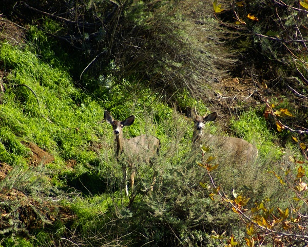 It wasn't because of tree cover, since there was little tree cover around. I just couldn't find them. Yesterday, I went back out again to hike that trail for several reasons, one of which was to rectify those DNFs. There were several new caches along the trail as well, the weather was beautiful and I had cabin fever.
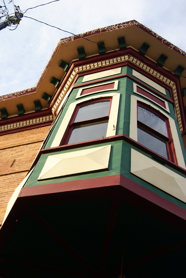
It has rained for most of this vacation and I really haven't been able to get out and do any kind of hiking this past couple of weeks. The weather was finally cooperating and I was going to take full advantage of the situation. The NEP provides a 3.25 mile loop trail, but with spur trails you can walk a lot longer. I ended up walking just over 5.6 miles for my morning hike, with an elevation gain of over 2000 feet.
Fortunately, the gain was very gradual, so it didn't seem like I was gaining much in elevation, yet every mile marker post I came upon, it told me I was climbing. Had I gone the other way on the loop, the gain would have been steeper and more intense, but I knew that from the last time I'd hiked the loop.
With the mountains as a backdrop, I was able to get some really good pictures, more than I can probably post here in three different post, so I'll have to post them gradually over the coming weeks. There was a lot of snow on the peaks, which top out at around 8800 feet. I was hiking at 2300 to 2500 feet above sea level so you can see there's quite a bit of snow on the mountains. Last night, the overnight low got down to 29˚, which is quite cold for our area, which also means that the snow will stay there for awhile.
The daytime temperatures were warm enough that I was able to hike in shirt sleeves yesterday. That also means that once again, people back east will watch the Rose Parade out here tomorrow and see people enjoying the wonderful weather and wonder to themselves why they live in the snow. 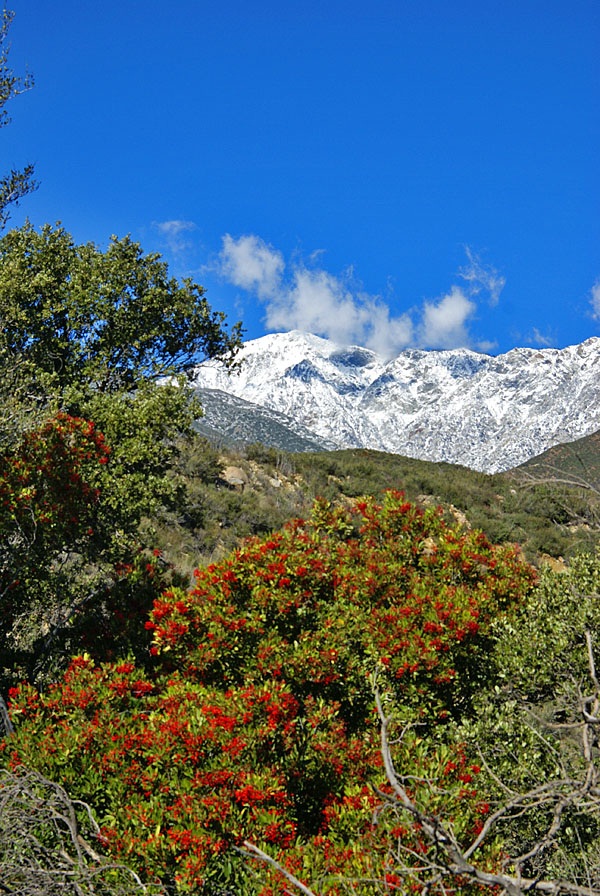 I think the single best advertisement for Southern California year after year is the Rose Parade and to a lesser extent, the Rose Bowl. Only once since I was born has it rained on the Rose Parade. That's a pretty good track record.
Needless to say, I enjoyed the weather yesterday. The setting was perfect for a good hike and for some caching. I was able to find those caches that I couldn't find over a year ago, plus all of the others that I had planned to find. I saw several deer, one that crossed right in front of me on the trail and two others who watched me warily from a good distance away. It was a good day, one that was a fitting end to the old year of 2010.
Tomorrow begins a new year, one that I'm sure everyone hopes will be the best year ever. Resolutions will be made and some will be kept. I resolve to continue to have fun while geocaching. I found more geocaches this year than in any past year. It's quite an achievement, especially since I was out of commission for several months due to personal reasons. I was just lucky the rest of the time I went caching I guess.
I will not resolve to find a certain number of caches. In my opinion, resolutions should be self improving. Finding more caches next year, does nothing to improve myself I believe, although it will probably get me on the trail more so I guess I can resolve to continue to be more physically fit than in the past.
I also resolve to post more often here. As I look back to when this blog was started, I can see my post counts fall every year. 116 in 2008, 100 in 2009 and only 80 this year. I plan to reverse that course this year. And so to all of my readers out there, please enjoy tonight, make it safe and may 2011 truly be the best year ever.
Pictures were taken at or near the following geocaches:
NEP_pd4 - by Ranger Rick
Washed Out Plumbing - by bustindustin
Friday, December 31, 2010
Finding caches I couldn't find

Wednesday, December 29, 2010
More than I can chew
Earlier this month, I mentioned that I was going to attempt the 365 project. I figured that I'd start the project on the first of next month and just end up taking a picture every day for the next year. Already, I now know, I've bitten off more than I can chew.
I uploaded two pictures earlier this month, just to see if this project would be difficult.  In one sense, I can see where I could do this, but in another sense, I know myself well enough to know that I won't be able to do this every day over the next year. I love taking pictures, but at the same token, I'm also a perfectionist. I will not publish a picture of my toenail just to satisfy a daily challenge. It would get onerous very quickly.
Several years ago I challenged myself to try and find a cache for 33 consecutive days. At that time, I was the main person picking up the Tadpole from his elementary school. Because of when his Spring Break was and my Spring Break, I figured there was going to be a 33 day window where it would be relatively easy to find a cache every day during that period. And so I attempted it.
Once the 33 days went by, I continued finding caches each and every day. Some days were relatively easy, while others were more difficult to accomplish but I persevered up until day 57. That day, I ran into a string of caches that I couldn't find and it became frustrating enough after five DNFs that I just said to myself, enough. I wasn't having fun anymore, so I ended the streak. There is no way I'd ever want to attempt any kind of consecutive streak again. I think the longest streak I've had since that time has been 11 consecutive days.
And so I thought I'd be able to take a picture every day for 365 days. Uh huh. Right. The nice thing about the 365 Project is you can upload pictures to specific days. It doesn't hold you accountable for an every day post. So this project will take several years to achieve fullness, but I can live with that. The quality of the pictures will be much better than if I ended up taking a picture every day and I will also continue to enjoy the project as it develops.  I know myself well enough that if I were to attempt this, I would end up hating it in the end. I don't want to do that.
In the meantime, from time to time, I will post updates of my progress on that project. I've noticed many other bloggers contributing to their own blog by having a Wordless Wednesday every week, which just includes a title and a picture. I may end up doing something like that as well, although the way I like to write, actually having to have a wordless day might be painful to me. But I can always try it and if that doesn't work out, so be it.
The two pictures posted here are the two I've posted thus far this month. One is of an inch and a half long millipede we spotted out in the desert the week before Christmas Day. We actually saw two different ones, but this one was a little bit more cooperative than the other. The second picture is of our California Desert Tortoise (yes, I have a permit for it) that lives in our back yard. It came out of its burrow on Christmas Day and was sunning itself under one of our orange trees. Today is the first day since Christmas where I haven't seen it wandering around in the back yard. I suspect the rain today had something to do with that.
Please enjoy these offerings and others in the future.

Friday, December 24, 2010
Sobering thoughts
Whenever I go geocaching, I'm always on the lookout for memorials. There is something about memorials that deeply touch me, especially soldier memorials. 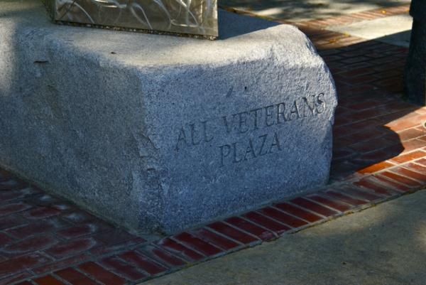 Perhaps it's because I was lucky and was never forced to serve. Each of us must choose our own paths and mine didn't follow a military path, although it's not because my parents didn't try to influence me in that direction. I just knew in my heart that the military life wasn't for me.
But for many men and women, it is their choosing and I salute them for it. It must be extremely difficult to be away from your family during the holiday season. I can't imagine being thousands of miles from home, away from my family, let alone having these conditions imposed upon me and also being shot at in the process.
I've made it my custom, when I come upon a soldier memorial to take as many pictures as possible. The memorial is a poignant reminder of those who never come back from those far distant lands. It reminds me of the family left at home grieving for their lost husband, son or Daddy. It reminds me that I have been truly blessed to live in a country where we value freedom so highly.
A friend of mine is serving in Afghanistan right now, away from his wife and children. A former student of mine was killed earlier this year over there one week before his 20th birthday. 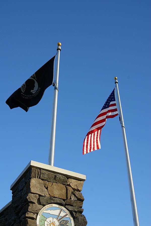 My niece's husband served in Afghanistan several years ago and is now safely home. My nephew serves on a carrier in the Pacific. His carrier group was scrambled last month when North Korea decided to bomb a small South Korean island. At the moment, he's on leave and is safely home in California celebrating the season with us, his family. My thoughts and prayers go out to all of these people and many others who I don't know.
I leave you with a You Tube video that a friend of mine posted earlier today on Facebook.
I know we will always have soldiers overseas, but hopefully next year, we will have fewer of them in harm's way.
Merry Christmas to all, and to all a good night.
Pictures were taken at or near the following geocaches:
Cricket's Reflection - by GeoCrickets
"United We Stand" - by Lizard Man

Monday, December 20, 2010
Here I go, There I go, Where I go
Last month, while on a road trip to Stockton, Chaosmanor and I were fortunate to attempt a couple of Wherigo caches. A Wherigo cache is similar to a multi-cache in that you have to find clues as you walk along a route planned out by the cache hider. You need a Wherigo enabled GPS unit in order to complete a Wherigo cache. 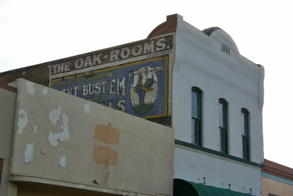 The Geocaching website explains a Wherigo cache this way:
Wherigo is a toolset for creating and playing GPS-enabled adventures in the real world. By integrating a Wherigo experience, called a cartridge, with finding a cache, the geocaching hunt can be an even richer experience. Among other uses, Wherigo allows geocachers to interact with physical and virtual elements such as objects or characters while still finding a physical geocache container. A Wherigo-enabled GPS device is required to play a cartridge.Since I don't have a Wherigo enabled GPS, I haven't been able to find one until now. In fact, the closest Wherigo caches is 20 miles away from me. Chaosmanor recently purchased a Garmin Oregon GPS unit and it is one of the ones that are Wherigo enabled, so when we were planning out this route, I spotted a couple of Wherigo caches in Lemoore, CA and decided to put them in our bookmarked route.
As I noted above, doing a Wherigo is similar to a multi-cache, only the clues are given to you on your GPS unit. You load the cartridge form the Wherigo website into your GPS unit, then head out to the starting coordinates and play the cartridge. There are several ways to play the game.
One way is to play locationless cartridges. These cartridges can be played anywhere. There's a tutorial at the Wherigo site that allows you to try a Wherigo out before actually doing an actual physical Wherigo cache. When we got to Lemoore, Chaosmanor let me have his GPS and I tried the tutorial out in a little park south of the first cache we were going to attempt. If you're familiar with GPS units, the learning curve for these isn't that tough, although it took five to ten minutes for me to get the hang of it. Once I solved the relatively easy tutorial, we walked across the street and tried the physical Wherigo.
This second cache was a relatively easy cache to do. It was located in a large park, with very little tree cover, giving us ample signal strength to our GPS. We picked up the clues by answering questions, then headed to the second waypoint. Each waypoint is located in a zone, which is the way the Wherigo cartridge works.
 Once you get to the next zone (which can be a variety of sizes), you then can get your next clue. Eventually, the clues and cartridge took us over to where the cache was actually hidden allowing us to log our find.
 We then headed into downtown Lemoore to attempt the other Wherigo cache. We parked near the starting point, opened the cartridge and began. This one was a little trickier since we were walking through the old town section of town. Tall buildings cause signal bounce, so we didn't always get as close as we could to the center of the zone in order to answer the questions which would lead us on to the next waypoint. This could be because the zone may have been too large. I'm not sure on this, but it's something to consider if you're going to attempt a Wherigo in a city environment.
I enjoyed the second Wherigo more than the first probably for a couple of reasons. One, the first one was in a park, where any kind of cache could have been hidden. There wasn't much interest generated outside of going through the steps and finding the cache. I also was new, it being only my second attempt following the tutorial. The downtown Wherigo, I had a little bit more experience utilizing the cartridge and the buildings in the downtown area had some local history attached to them, which made the walk more interesting in my opinion. Your mileage may vary depending upon your own experiences.
I enjoyed walking through the downtown area. I'd been there previously, finding a virtual cache in one of the areas we walked through on this caching experience. Looking at some of the turn of the 20th century buildings was enjoyable to me, especially looking at some of the Victorian architecture. It gave me an idea for a Wherigo cache in my local area, although I'm not sure how I'll be able to set it up, since I don't have a Wherigo enabled GPS at the moment.
I'll have to download the Wherigo builder onto my other computer and try it out. Perhaps I will be able to create one, without the need of a Wherigo enabled GPS. We'll have to see about that.
There are quite a few Wherigo caches in California. I noticed one in Yosemite Valley near Yosemite Fall. I found this interesting because the National Park Service doesn't allow physical caches, but when I investigated it further, I discovered that the physical part of this Wherigo is outside the park in nearby El Portal. I've heard rumors about Geocaching possibly bringing back the virtual cache. If this does become a reality, I can see where some very interesting Wherigo virtuals could be created, especially in a National Park environ.
The upshot of all of this was it was a new experience for me to try, using my GPS. They probably aren't for geocachers who are numbers runners. They take more time than the regular cache. I would estimate the first cache we found in the park took us 15 minutes to complete and the second one in downtown took us closer to 45 minutes. We might have been able to solve the second one more quickly but we did get sidetracked. All in all, they were enjoyable experiences, something that I'd like to try again in the future. I'd also like to create one.
Pictures were taken at or near the following geocache:
Lemoore's First Wherigo! - by JohnE5

Friday, December 17, 2010
Night caching and photography
Every now and then there are surprises that show up while you're out. Chaosmanor and I, while on our road trip last month, stumbled upon a cache at night. Now, I don't do much night caching and we weren't really going to do any night caching on this trip, but we were on our way back to our hotel room and I spotted this cache just off the freeway, so we thought we'd attempt it.
 Once we got there, we discovered this particular cache was a virtual cache. After we got the requirements for the cache, I went back to the van to get the camera to get some shots of this statue. Had I had my tripod, I might have been tempted to try some long exposures, but I figured some flash shots would work this time.
This leads me to another topic, that of the 365 project. Chaosmanor showed this to me, so I thought I'd look into this as well. I'm going to try and do a literal 365 day project, starting on January 1st, 2011 and work through the year. I probably won't get anything really earth shattering on some days, maybe even just the top of my foot or something along that line, but I do take a lot of photos and I think I'd like to try something like this. I keep seeing the 12 on 12 projects, taking 12 photos on the 12th, but for some reason, I always seem to forget about the day until after the fact. Perhaps with this, since I know I'll need to take at least one photo each day, I'll persevere. We shall see.
Picture was taken at the following geocache:
Worthy Steed - by Original owner gallahad Adopted by Pamelot 7-2007

Thursday, December 9, 2010
And the hard part begins
I found two caches today. There's nothing really earth shattering about that, but it helped me fill another calendar date. Almost 10 years of caching and I'd never found one on December 9th before. But, as the title says, the hard part begins now.

I have 19 days left to fill. Five are scattered in September and October. I'm not worried about those, nor am I worried about the ones left in January and February. I'm worried about the ones that I have to fill in December. I have 6 more dates in December to fill, four of which are directly in the week of Christmas, including Christmas Day. As I noted last year at this time, December can be a very tricky month, because it looks like there's all this free time available to do things, like geocaching, yet when all is said and done, much of that first week is tied up in doing things preparing for that big day.
Six open dates in the nice days preceding Christmas Day. The only date I was able to fill in last year was Christmas Eve. This should be interesting to see if I can pull it off this year.

Sunday, December 5, 2010
Desert creatures and other things
My last cache hide was a multi-cache hidden up on my favorite trail. It's now been hidden for over a month and has a grand total of two finds, one of which is the beta tester who went with me when I was laying out the final coordinates. 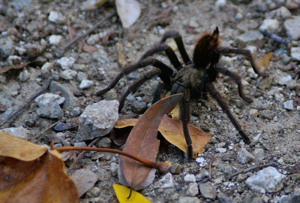 It's really too bad that the cachers around where I am aren't more of a hiking bunch. I think they're missing out on some very nice hikes and caches all in the same boat, but that's another story altogether.
The reason why I bring this up is while on that hike, CraigsOutside and I encountered a tarantula on the trail. That's not necessarily surprising since the area is know to have tarantulas, but what is surprising is before that hike, I've seen a tarantula in the wild only one other time and it was about 2 weeks before that when I spotted two others.
One was on the trail and was actually discovered by a couple of bicyclists coming down the hill. One stopped about 50 feet up the trail from me and pointed it out to his riding partners who were behind him. By the time I got up there, it was just ambling across the fire road. Later on that same hike, I nearly stepped on one at ground zero of the first stage of my multi-cache. If that doesn't get your adrenaline up, nothing will I guess. Either that, or you're just a calmer person than I.
I've encountered my fair share of creepy crawly things while out geocaching. I've spotted snakes from time to time. Once, while out hiking we came across a very large rattlesnake. Unfortunately, it wasn't really pleased with us being there, but there wasn't a whole lot we could do about it at the time, since we had it surrounded on a couple of sides. We did the best thing we could do and that was to back up and make wide circles around it. This snake encounter was in May, when the environment is becoming more habitable for all creatures in this area, but particularly reptiles, since they rely on the air temperature for warmth.
My friend CraigsOutside was bitten last year by a rattlesnake (read about it here). 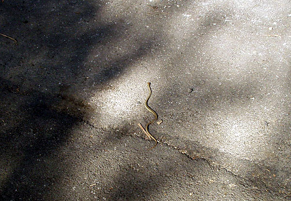 This happened in November, which seems a little strange since you would think most snakes by this time in the year would have gone underground and started hibernation. Southern California is a little bit more temperate and so in this area, we need to practice caution at all times. One can never tell, obviously, when a snake could be lurking nearby.
Before last year, I wouldn't have had rattlesnakes on my mind at all in November or December or any of the cold months of the year. Craig's encounter had me a lot more cautious yesterday while I was looking through a pile of rocks on the side of the road. I keep thinking that I really should get a hiking stick of some kind to carry along with me. Many of my friends take one along when we go on hikes. I've never found the need to carry one, mainly because it's one more thing in your hands while you're walking. Maybe I need to rethink that.
I'll be hiking out in the desert over the next couple of months. It's the most pleasant time to be hiking out there. It's cool and comfortable, much more pleasant than during the middle of the summer time. There's another figure out in the desert that we're going to create. I've written about the Smiley series and the Groundspeak logo in the past. Now, in the same general area to the west of the Smiley Series is a large PacMan. There are 30 caches, plus one mystery which makes up the eye of the PacMan. I have this feeling after we go out and find all of those, we might be singing "PacMan Fever" for awhile.
It appears as if each cache is about two tenths of a mile from the next cache, meaning this will be a 6 mile hike. That will make for a good hike if we do it all in one day. If we spread it out over two days, it'll be two good hikes. Anything over a mile is a good hike, in my opinion. And since one of our proposed hiking dates happens to fall on one of my open cache dates, that's always a bonus.
Pictures were taken at or near the following geocaches:
Give or Take 20ft - by madmaxxawr
Curiouser and Curiouser - by Terra Girl, Bean Dog, and my faithful sherpa Max