Every time I go caching, I log the caches on-line. Then I update my spreadsheet and then the mapping file so I can update the map that I keep on my profile. This past weekend, I suggested to the Tadpole that I could create a map for him. He was enthusiastic 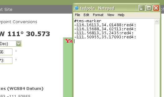 about this and I decided that it would be now or never.
I also wanted to see how many counties he actually had on his "official" finds list. He's recently become interested in finding the 58 county challenge cache. His "official" county count is small, only nine counties because he refuses to count any cache that he found with me before he started his own geocaching account. That's fine, except that we have some work to do for him to catch up to my county find total so we can get this cache together.
While I was making his map, I thought it might be a good idea to share the know how so that others, if they wish, could create a map of their finds. I've started to write something like this several times in the past, only to be stymied by the technical aspects of this, so I'm probably going to break this up into separate parts.
The first part of making a Tiger map is to create a text file of all the data points you want to include on the map. In this case, I had slightly over 300 data points from all of the Tadpole's cache finds. I've found that Notepad seems to work best when creating a .txt file, so I just opened up a new one of those and began inputting the data. In this case, the map file needs to start out with the header, #tms-marker as shown above in the picture. Then it's just a simple task of adding all the data points.
All the geographical data points have to be in decimal format. Since the cache pages all list the coordinates of the cache in degrees and minutes format, you'll need to find the decimal equivalent. So where do you get the decimal translation from a geocache page? 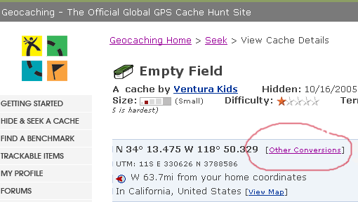 Click on the link on the cache page labeled Other Conversions. Then use the WGS84 Datum decimal coordinates for the cache and input those into your text file just like the example posted above. The decimal coordinates (East/West & North/South) are separated by a comma, but not spaces. At the end of the two decimal coordinates, type a colon. In my example I also have a red4 followed by a colon. This reduces the size of the red dot on the map.
Expect to spend some time entering all the coordinates into the text file. I took a couple of hours to input all of the Tadpole's cache coordinates into his text file, but that time is a one time deal. If you keep up to date after the initial inputting, it doesn't take much time at all to maintain the file. I'll explain how to create the parameters for the map in my next post.
Wednesday, April 29, 2009
Creating a caching map

Sunday, April 26, 2009
Urban Jungle Road Trip
The Tadpole and I went on a road trip Saturday, ostensibly to grab some virtual flags in the Los Angeles Basin. The flags were stretched all the way from Thousand Oaks to the west of us, down to San Clemente south of us. S ix of them lay waiting for us to drive up and claim the flags, and thus, the points for the flags. We were successful in getting all six flags. The red dots on the map are the different locations we went to get the flags. We ended up getting only one geocache, one that happened to be near the flag in Thousand Oaks. We weren't sure if the Tadpole had found a cache in Ventura County yet, so we stopped there to get this cache to be sure. We remembered later that we had cached together in Ventura County, so in reality, the cache was just a bonus, not fulfilling any kind of challenge, but just there for the fun of finding it.
The thing I love about GeoVexilla is each flag can be worth different points to different people playing the game. For example, we "found" flags of Nigeria, Saint Pierre and Miquelon, St Vincent and the Grenadines (shown below), Nicaragua, Poland and the United States. When a flag is found, the website computer generates a five flag set. The first flag in the set is worth 1 point. Any other flag found for that set would be worth 2 points for the second flag, 4 points for the third, 8 points for the fourth and 16 points for the fifth. Each set is worth a possible 31 points. I could be finding a flag with a friend of mine which might open a new set up for him, but could be worth 8 points to me, because it's already in an existent set. When flags appear on the web site, you have to be ready, because they have a  limited lifespan. Most tend to last about two weeks, but I've seen some come and go in just over a week.
It's also possible to move flags around. If you look at my flag sets and scroll down to the bottom, you'll find several sets that are empty. That's because I've moved some flags that could fill in other sets. I enjoy it, because I enjoy going to places where the possibility of getting the flag could be suspect. Not all flags can be grabbed, due to property laws, or terrain, whereas, technically, all geocaches should be able to be grabbed, since another human being has been there already to place the cache.
The GeoVexilla game site is another way to use my GPSr. My son likes finding virtual flags, if nothing more than he gets to see the flags up on my flag sets. I noticed a flag in the hills south of Thousand Oaks. I hadn't ever seen that particular flag design before, so I looked up the island of Niue. I learned it's one of the largest coral islands in the world.
The other thing the site allows me to do is expand my geocaching area. Yesterday wasn't a geocaching type of day for us, with each of us preferring to just grab the virtual flags.  Other times, with fewer flags in an area, we might pinpoint a flag, grab it, then find some caches in the general location. I've discovered a couple of nice trails this way and have plans to go back into Riverside County, south of us this fall when it gets cooler to hike this trail that we found because of the virtual flags.
Now that we have our vacation plans formulated for this summer, he and I can start looking at our route to check on geocaching possibilities. Scouting for flags will have to wait until close to our camping trip since they have a limited lifespan on the site. Overall, finding the virtual flags has been a pleasant addition to our GPS using experience. Much, like geocaching, it gets us out and about, gets us to explore new territory and helps us enjoy the outdoors and each other. Try it, you might like it.

Tuesday, April 21, 2009
All shapes and sizes
While up in Santa Cruz, I attempted to find the cache, Benchmark 941 3745 TIDAL 4. Obviously, a benchmark is located near where the cache was hidden. I could find neither and the cache isn't a micro. Sometimes the geosenses work and sometimes they're on the fritz. The c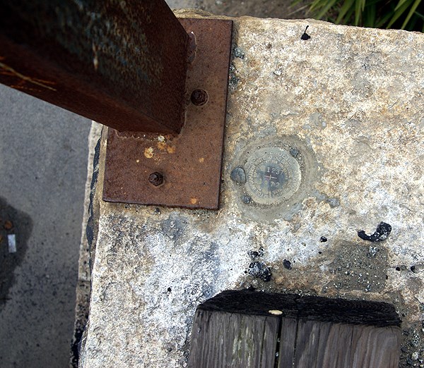 ache, in my opinion is in an awkward spot, where you have to stand on a corner where three streets come together, with one street being blind, so it's not the most ideal spot for a cache, but it is an interesting place for a benchmark.
Looking at the picture of the benchmark on the cache page, I'm very surprised that I didn't find it. It seems to be a typical/standard USGS benchmark disk. And yet, not all benchmarks are that kind of standard disk, nor are they all obvious. This one was hidden by leaves, but it must be there, since it has been found at least twice since I visited the area 10 days ago.
After finding the Neary Lagoon virtual on the same walk as the attempt on the benchmark cache, I headed back to the motel and discovered there were two more benchmarks along the Boardwalk. When my son and I went to ride the Giant Dipper later that evening, I didn't take my camera with me, so I figured that I would log them in the morning before we left. Both were easy to find, one being the standard disk located on a piling for a railroad bridge that is near the eastern edge of the boardwalk. There was a walking trail right next to it, so I really wasn't putting myself in any kind of danger by going over and taking a picture or two of the benchmark.
The other benchmark was at the other end of the boardwalk. It was the dome and cupola of the former 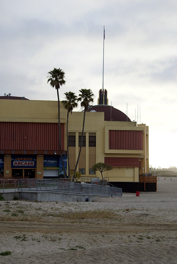 Casino on the boardwalk. Usually, when I think about benchmarks, I usually think about the round disks that I would discover in many of the national parks that we visited when I was younger. Those were the first encounters I would get with benchmarks and the images stayed with me. Now, here I was looking at a structure and recording it as a benchmark. They do come in all shapes and sizes. Looking over the list of benchmarks that I've recorded, there is a microwave tower, a church steeple, a lighthouse and a statue on top of a courthouse that were all benchmarks.
What this means, I guess, is if I want to log benchmarks, then I need to be prepared, because they seem to be all around, in some surprising locations and in some interesting shapes. They also aren't always where you think they might be. As I was thinking about the write up for this blog, I realized that I'd taken a picture of a lighthouse while logging an earthcache in Santa Cruz. Since the lighthouse down at Point Loma in San Diego was a benchmark, it stood to reason that this one might be a benchmark too. A quick scan of the local benchmarks revealed a lighthouse, but not of the one I took a picture. There's another lighthouse just to the southwest of that one and it's the benchmark. I didn't get over there to see that one, or take a picture of it, so it wasn't logged.
As in the past, my primary focus is on geocaching. I happened upon the two benchmarks, mainly because I had wireless connection in the motel room, so I was able to do a quick search for them. Most of the others that I've come across, have just been happenstance. But I think I need to at least scout out locations where I know I'm going, just in case an interesting one might show up.
That same weekend, while we were driving by my daughter's school, I saw something out of the corner of my eye, that looked suspiciously 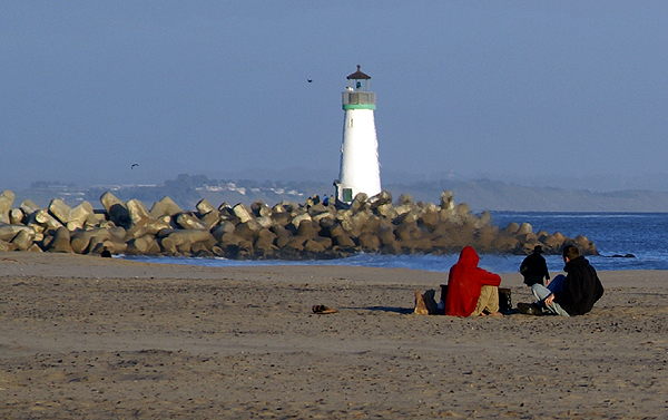 like a benchmark. It was a pipe that was crooked and out of place, but I didn't have time to stop and adequately check it out. Upon getting home, I did a search and discovered that this was indeed a benchmark. I missed it that time, but I'm going to be going up to Stockton many more times over the next couple of years, so I'll probably be logging that one some time in the future.
Pictures were taken at or near the following geocaches and benchmarks:
GU1944
GU4080
Seabright Beach Building - by TerryDad2 dedicated to 50sumtin

Saturday, April 18, 2009
Someone Else's Backyard
Long time readers know that one of the reasons I enjoy geocaching is it gets me out on trails in my local area. Basically, it gets me to explore my own back yard, 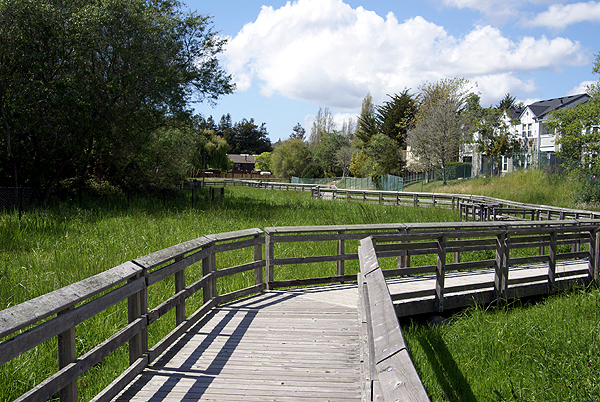 something that I probably wouldn't have done were it not for geocaching. Last weekend, I was in Santa Cruz and did some geocaching in between the tour of the campus and the boardwalk.
After the tour of campus, I could tell my son was tired. He let me know that he had a headache and so we went back to the motel room where he ended up taking a nap. I looked up geocaching.com on the laptop and discovered a small cache on the boardwalk, plus another couple of caches to the north of the motel, including a virtual. After getting the small cache under the boardwalk, I headed north.
The first cache was a bust. It looked interesting because there was supposed to be a benchmark there as well, but it was in an awkward spot, sort of in the middle of traffic. The cache page had warnings about little children and where they shouldn't be and I was uncomfortable looking for the cache because of the volume of traffic on the two streets that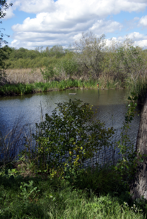 converged into one. I decided to pass on that one and headed over to find the virtual cache.
If you've ever been to Santa Cruz, you know it has hills. They're nothing like San Francisco's hills, but I got a good workout nonetheless. The street layout of the city, due to the hills and the curving bay to the south makes it difficult to make a straight line direction to anything, but I eventually found a way over to where I needed to be.
What I found was Neary Lagoon. It's a freshwater wetlands area in the middle of a residential area. At first I thought it might be a salt water lagoon, but that opinion was quickly changed once I started walking on the trail. At the beginning of the loop trail, there were interpretive signs that for some reason I didn't read. Usually, I always read the signs and look at the maps, but I didn't this time. Because of that I was in for the surprise of my life and a nice treat.
I had my choice of left or right on the trail and I chose right, mainly because that's what I ended up seeing first when I approached the entrance to the lagoon area. It was actually a very good choice, because I felt the climax of the trail was at the end of my hike, so it worked its way up to bigger and better things as I walked.
Almost the entire path, at least on the side I started was a wooden boardwalk over grasses and different kinds of flowering plants. There were view points along the trail with interpretive signs, all of which I read. The first part almost felt like I was infringing on some one's backyard because there were townhouses that literally 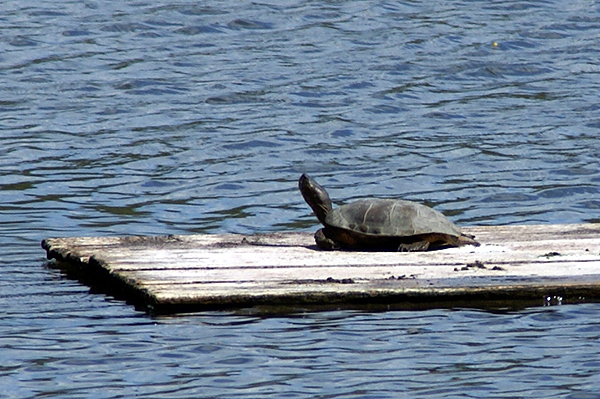 abutted the grounds of the lagoon area. About 200 feet or so of walking along this boardwalk, the walk made a left hand turn into a tunnel of bushes and smallish types of trees. I was unprepared for what lay ahead.
When I came out of the natural tunnel I was on the lagoon. The walk now floated on top of the water and there was a large island. I could see turtles sunning themselves on makeshift landings that had been provided for them. Coots and mallards were swimming in the water and sitting on the shoreline. The walk had become one of those pleasant surprises that geocaching throws at you from time to time. I was experiencing someone else's backyard this time, not my own, and it was grand.
At the far end of the loop was the virtual cache. I needed to get information off of the sign to score the smiley on this one. Originally, there had been a cache at the site, but somehow it disappeared. Perhaps a clumsy geocacher dropped it in the lagoon?  Whatever the reason, the hider decided to make it a virtual cache and it worked just as well.
Eventually, I left the lagoon and got onto a dirt trail that wound around the north end of the lagoon on the shore. There was a water treatment facility just to the north that I suspect is where most of the run off for this lagoon comes, but it didn't detract from the overall atmosphere of the walk.
Nearing the end of my walk, I noticed that I was going to end up crossing over a small "stream" that fed the lagoon. There was an area of water overflow here and much to my surprise, I ended up coming almost face to face with a very large Great Blue Heron. It eyed me for several minutes, giving me enough time to take a couple of pictures, then slowly rose out of the water, flew off and settled somewhere else in the overflow that apparently was a little bit more private. It was a nice chance encounter and a nice end to a very relaxing walk on the wild side of Santa Cruz.
This was the third time I've cached in Santa Cruz County. I haven't been disappointed yet with the caches I've found. Perhaps I could say I'm also lucky that I've ended up finding some real gems for caches up there. Who knows? Maybe the hiders in that part of the state just like to hide slightly better caches than in other areas. I did notice there didn't seem to be a high degree of cache density in the area we were staying, so that could be the reason. Whatever the reason, this particular cache ended up on my top 5% list for rather obvious reasons. Next time you're in the Santa Cruz area, you'll probably enjoy the hour of your time to walk around the lagoon.
Pictures were taken at or near the following geocache:
S.C. Birdwalk Cache - by grumpybear and jtkcacher

Thursday, April 16, 2009
A Walk on the Boardwalk
Last weekend, I took my older son up to Santa Cruz. We took off Thursday afternoon after I was done with school. I left so quickly after school, that I literally beat the school buses out of the parking lot that day. There was a method to my madness. 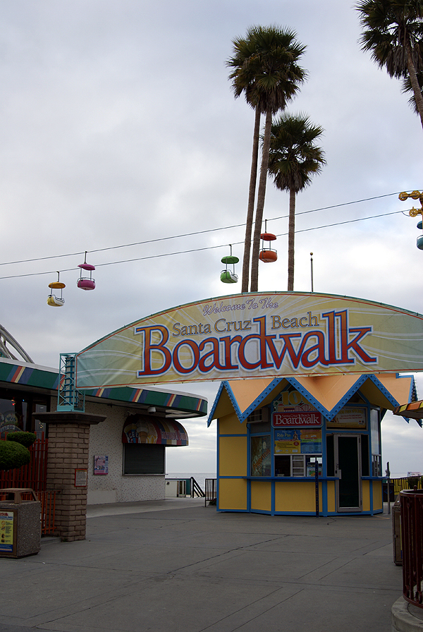 Getting out at 2:10 in the afternoon, afforded me the time to get home reasonably early, so the two of us could be on the road near 3 o'clock and thus miss most of the traffic. That worked to perfection and we were out on the Grapevine before any real traffic hit down below.
We got the Santa Cruz a little bit before 10 in the evening and both of us were tired, so we checked in and crashed. The next morning, I woke sometime around 7:30 and decided to go out on the balcony of our motel. Getting in late the night before, I was a little disoriented and wasn't sure exactly where we were in Santa Cruz, but was I in for a big surprise when I opened the door to the motel. The motel was literally only two blocks away from the Boardwalk, a popular Coney Island type amusement park right on the beach in Santa Cruz. That made our evening's entertainment easy after our tour of the campus.
Back in 1976, two friends and I took a senior trip following our graduation from high school. We explored almost all of what California had to offer back then, driving up Hwy 1, seeing Hearst Castle, Big Sur, San Francisco, the coast Redwoods, then cutting across the northern part of the state and visiting Lassen Volcanic National Park and Yosemite. We also stopped in Santa Cruz for a night since one of my friend's sister was attending UC Santa Cruz at the time. We crashed at her apartment and took a walk on the Boardwalk.
There is no entrance fee at the Boardwalk. The place prefers to charge by the ride. So many tickets would get a ride on Hurricane, or the bumper cars. 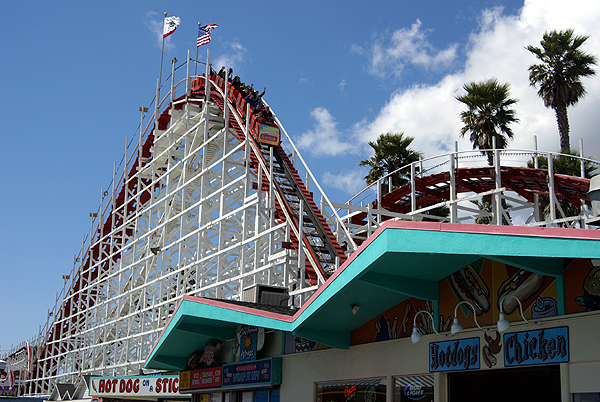 The primo ride there is the Giant Dipper a beautiful wooden roller coaster which first made its appearance on the Boardwalk back in 1924. The Giant Dipper is a classic woodie twister and has a very small footprint for a roller coaster. Its overall track length is only about a half a mile and it tops out and just about 70 feet in height. It's not like other woodies around the country like Beast at Kings Island in Ohio, or Colossus in Southern California. Yet, the Giant Dipper consistently gets rated in the top ten of woodie coasters by coaster enthusiasts surveys.
I really can't remember how many times I rode the Giant Dipper back in 1976, but I would hazard a guess and say it was about half a dozen times. It was a great coaster from start to finish. I hoped that it would be as good as I remembered it. My son and I worked our way up to it by riding Hurricane, a smallish metal roller coaster right near the 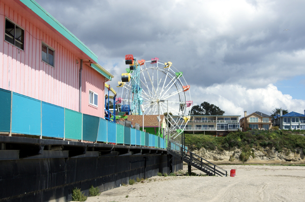 entrance to the Boardwalk. It was very jerky and not much for good dips. After getting off that one, we headed over to the Giant Dipper.
Getting in line, we waited patiently as the cars kept flying over the station, shaking it as it sped around and over it. We listened to the screams of the visitors as they rode the ride. It's all part of the ride as the excitement built. Then it was our turn and we got a nice bonus. 6 people were ahead of us and for some reason, they all wanted to go to the front of the train. Silly riders. The back is best and we had the prime seats for this ride, and what a ride it was. Whipped around in a dark tunnel and then up the lift hill we rose. Then it was over the first hill and it was non stop action as we plummeted and twisted along our half mile course. It was as good as I'd remembered it.
The rest of the Boardwalk was also as I remembered it, expensive fattening food and cheap carnival type rides, most of which spin you around in circles until you want to throw up. 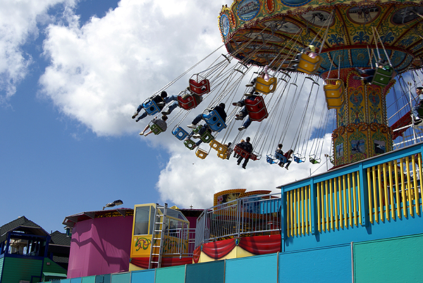 Those are not my cup of tea at all, but that one ride was worth every penny we spent to ride it. I kept pointing out to my son different things that I could remember from 33 years previously. I showed him the display of the old boards that used to be THE Boardwalk. Renovated in the mid 1980s, it's now just cement, probably easier to maintain and keep clean, but not really a boardwalk any more.
Still, it seemed to be doing quite a business for most of the day. I'd been down earlier to find a cache attached under the Boardwalk and it was fairly crowded for a weekday, albeit Friday during what might have been spring break for many. The deep friend Twinkies and deep fried cheesecake were tempting, but my son kept me in line and refused to allow me to indulge. 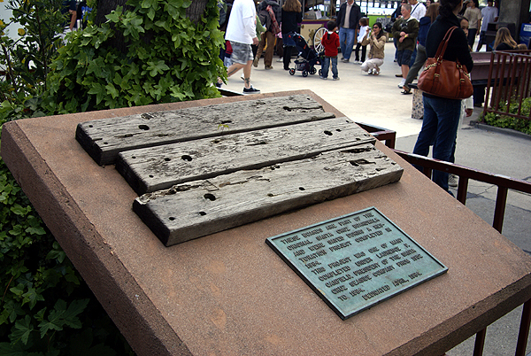 It was nice to see he was looking out for my welfare. I probably wouldn't have anyway, but it was fun messing with him nonetheless.
Since my son has decided that he's going to attend Santa Cruz, I probably will have ample opportunities to enjoy the Boardwalk again and again in the future. I doubt if I'll ride the Hurricane again, but the $4.50 I spent to ride the Giant Dipper, will be spent again and probably again. And even though the surface is cement now, I couldn't help but hum a tune by the Drifters as I took a last walk on the Boardwalk.
Pictures were taken at or near the following geocache:
Under the Boardwalk - by little_bear_blue and Big Green

Tuesday, April 14, 2009
Less than 5%
For those of you who have been following this, you know I have a Top 5% bookmark list of what I consider really good, well done caches. I don't believe the list has ever gotten up to 5 percent. As of this morning, I have 87 caches that  I have placed on the top 5% list. With over 2400 finds, I could have 120 caches on that list. I'm not sure if the fact that I don't have 5 percent on the list is a good or a bad thing. It's really just the way it is.
Today, as I was looking over the list, I noticed two of the caches have been archived. It's been my practice to remove the caches from the list once they've been archived. Since no one can find them, it doesn't make sense to keep them on the list. I've made on exception with that guideline. I keep Who waxed Mr. Ed? on the list because it was a virtual, so there wasn't any cache container to find, and because the ride through the area is still what got the cache on the list in the first place.
The first cache that I removed was called Rock in a Hard Place. There was a certain creepiness factor involved with this one. It was hidden underneath a footbridge in a regional park near me. There were lots of spiders crawling around in the support beams of the bridge. I liked the fact that you could be under there looking for the cache and people could be riding over the bridge and not realize that you were even down there.
The other cache was an urban micro. Almost all urban micros never make my list. This one, however, was very cleverly done, being situated outside a coffee shop. There was a bench nearby, with a statue on the bench. The cache page directs you to sit on the bench and think about it. That particular day I was with a group of cachers and we all ended up sitting on the bench to contemplate where the cache might be. When it was my turn, after sitting with the statue for awhile, it dawned on me that he might be looking at the cache. Sure enough, it was hidden in a support for a parkway tree and the statue was "looking" right at the tree.
It became a simple maneuver of, "hey, why don't you take my picture while I stand over here." Thinking about that cache brings back very fond memories of the day spent caching with 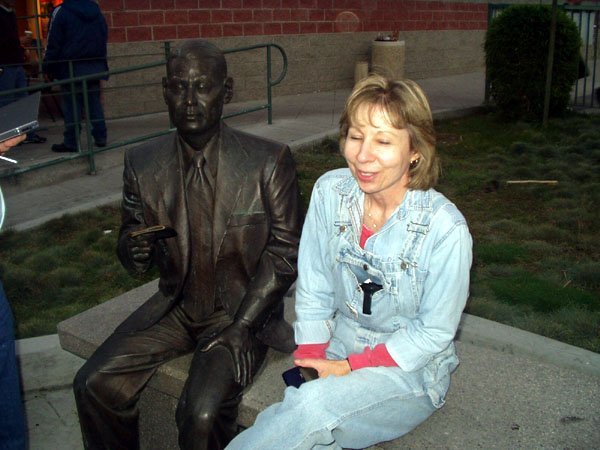 friends. We all got a good laugh at the way the cache was hidden and how the cache hider incorporated the surroundings to help cachers find the cache. Unfortunately, the city of Los Angeles came along and decided the parkway tree didn't need the support anymore, so the support and the cache went away. And so Little Tokyo muggle-me-not is no more.
We all know that caches won't necessarily last forever. This game is forever changing and so caches come and go. Still, it's always sad when a good cache disappears for whatever reason. These types of caches, the ones that make you think, are one of the many reasons why I like to geocache. It's like solving a puzzle and some of the puzzles are more complex or more fun to do than others. The really good puzzles get to be on the list.
Pictures were taken at or near the following geocaches:
Who waxed Mr. Ed? - by fooshfoosh and family
Little Tokyo muggle-me-not - by OLdweeb

Sunday, April 12, 2009
Alameda
On Saturday, my son and I drove from Santa Cruz up to Stockton to visit my daughter. We'd been touring UC Santa Cruz because it's where he has decided to attend college beginning in the fall of this year. The rest of that story will be 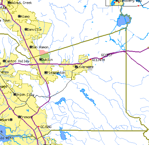 completed later. As we drove, I had it in the back of my mind that we would be driving through Alameda County and that I might stop and get a cache or two along the way so I could mark off the county. This would put me one county closer to the 58 county challenge that I've been working on for several years.
The first cache we found in Alameda County was Curtner Coppice. It's (GCJGNG), which is located to the southeast of Fremont. For me at least, it was a little tricky, only because I wasn't able to see the hiding place right away and I was taking the clue for the cache a little bit too literally. Eventually, I was able to find it, obviously and add Alameda County to my list of counties in which I've found caches. I found two other caches in the county (just east of Livermore) just to be on the safe side. With the first cache, we'd just passed the county line marker sign and I wasn't sure how the county line ran, so I wanted to make sure by finding a couple of other caches later on. You can see by the map, that I was well within the county line for credit.
That brings me to 32 counties. I have but 26 more to go. As noted previously, it probably won't happen this year, but could happen in the fall of 2010. I'll need two trips north, one on the west side of the state and then a second trip on the east side of the state to get all of the counties in the northern part of the state.

Wednesday, April 8, 2009
College road trip
Tomorrow marks the first road trip of the season. My older son (the Runner) and I will be embarking on a road trip to visit UC Santa Cruz, where he will be matriculating for the next four years. It hardly seems possible that he's already a senior in high school, and yet, he is there.
Our trip begins as soon as I can get off from school on Thursday. Then it will be a rush to try and beat the traffic in the Los Angeles basin. If we're lucky, we should be in the central valley before 5 o'clock.
Our route will take us up Interstate 5. I don't have much caching planned for the first leg of our trip, mainly because the daylight hours will be spent getting out of the area. I figure we'll eat on the way at a burger place where I know there is a cache waiting to be found. That may be out only cache of the day.
Friday, we have a tour scheduled on campus which should last us a couple of hours. Looking at the map of the campus, it looks large and hilly. My son will get lots of exercise up there, but he's used to that. After the tour, we have much of the day left to enjoy the city of Santa Cruz. Part of our tour will include a walk on the Boardwalk.
Saturday morning, we'll head northeast to Stockton to visit with my daughter at the University of the Pacific. We plan to spend part of the morning driving and caching up there. If things go well, I'll be able to get Alameda County off of my "to do" lists in California, leaving me one county closer to the county challenge cache. The rest of the day will be spent visiting with her, enjoying her campus and going to Easter Vigil service that evening. On Easter Sunday, we drive and cache homeward, traveling down the much friendlier Hwy 99. All in all, it should be a very good trip.
Picture was taken at the University of the Pacific at the following geocache:
Smell the Roses - by PuzzlesRUs

Monday, April 6, 2009
This is Sparta!
Having not seen the movie 300, I can't comment and I'm not sure how my son knows about this since he's but thirteen and hasn't seen it, unless it was at a friend's house, but this past Saturday, the Tadpole passed a milestone in his caching, that of 300 finds. 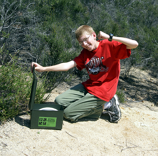 Technically, it wasn't his 300th because he's found many more than that, but he's a purist, so it is his 300th find. Confused? You really shouldn't be.
When I first started caching, I didn't think about the possibility of any of the kids developing a life long like to this silly hobby of mine, so I didn't think about getting any one of the kids their own account. Nor did I think about logging the logbook with their name. Whenever we went out as a family unit, I just signed Webfoot, and we moved on to the next cache. Many times, one of the boys found the cache, but neither one of them ever signed a log. Consequently, the Tadpole has found more caches than his official 302 finds that he's logged on line. Like I said above though, he's a purist. He refuses to count those in his find total because he hadn't logged them with his own signature.
I can't even begin to tell you how many he'd actually have if I'd taken the time to put his signature in along with mine, but I would be willing to bet it is close to a couple of hundred more caches. The cool thing about this is that's the way he wants to play the game.  This is probably because he realizes it's just a game and that perhaps it's really not about the numbers, although he sure looks happy celebrating a particular number.
The cache before this find was his first find in San Diego County. He's starting to get interested in logging the 58 county challenge which I've written about on numerous occasions. He started to pester me Saturday afternoon about finding a cache down in Imperial County, which for those of you outside of California, is in the southeastern corner of the state. It's mostly desert area, but the Salton Sea is a pretty impressive site, so I can see the interest in heading out there again. I've already found several caches in Imperial County, but I'm more than willing to help him out. I told him that perhaps at Christmas time, when the weather is decent down there in the desert, we might make an overnight stay and find several caches out there. He's up for that idea.
So anyway, here's to you, Tadpole. You are a great caching partner.
Pictures were taken at the following geocache:
Cassattack - by momobomp

Sunday, April 5, 2009
Truth in Advertising
The Tadpole and I went caching this weekend. We found this cache for our last cache of the day. We spent a great deal of time looking in the bushes near ground zero on this cache because the cache page said the cache wasn't in the sign. We were looking for a 3 quart Tupperware container, something that should have been quite obvious, even if  slightly cammoed as the cache page indicates.
We found the small yellow tube (it's either small, or my GPSr is gigantic), in the sign. The hint even said it was in the sign. Now we were confused since we were getting contradictory information. The cache page said it wasn't in the sign, but the hint said it was. After looking through the logs of other cachers, it's now apparent that this is a replacement cache for the original. In my opinion, this is just lazy caching. The hint has been changed, yet the description hasn't. I believe it's up to the hider to take care of his or her hides, not rely on other people and then clean up the cache page after the fact.
This is one of the reasons I don't have a boatload of caches hidden. It takes time and effort to set up caches and then maintain those caches. This isn't maintaining. This is just lazy caching. And I know I'll probably hear from someone about life getting in the way of the hider fixing up their caches. If they had the time to change the hint, then they had the time to either post a note about it, fix the cache page or temporarily archive it for the time being. Then again, I've been known to overreact from time to time and this could be one of those occasions, but even the Tadpole noted, "How could that be a regular sized cache?" Out of the mouths of babes.

Wednesday, April 1, 2009
Best Cache Ever
It started out like any other day, but soon, it would be twisted beyond my imagination as I embarked on a journey to find a simple cache that had eluded me in the past. I wanted to make sure this cache didn't end up on the permanent DNF list. I have to admit, when I woke up that fateful  morning, I wasn't sure whether I could handle the stress of another failure. Three migraines had been caused because I couldn't decode a simple cypher to unlock the mysteries for this particular cache.
That day, however, was different. I had had a good night's sleep and my mind went into zen mode as I whipped through the cypher, decoding it in record time. I'd finally gotten over the hump and saw where my mistake had been all this time. Once that was accomplished, all I had to do was pack my gear and get on the road. I had a long drive and hike ahead of me and I was already burning daylight.
The trip out was rather uneventful, especially if you ignore the train wreck that caused many lookie loos to stop at the side of the road. I was more focused than them and kept moving. It wasn't until hours later back at home that I found out the the train wreck had been caused by a meteor from outer space hitting the ground and undermining the tracks at that particular point. What's amazing was there wasn't any plume of smoke after the meteor hit. Very strange indeed.
Once I got to ground zero, my first clue that I had to find was a pony. Supposedly, this pony had some kind of clue literally hidden on it 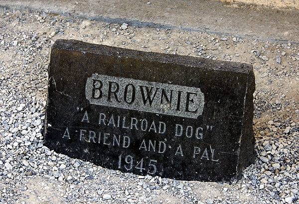 that would guide me to my next destination. I could not believe my luck when the pony ambled up to me without regard for it's own safety and immediately whispered the clue to me, giving me quite a sensation . Pony's noses are rather hairy and it tickled.
Off I went. The pony had directed me to Route 66. But of course. All great caches in the past that I had found were always found on or near Route 66, the Mother Road. The problem was Route 66 couldn't be found in many spots. I had to find a spot where several important ingredients fell together in one unlikely spot. The spot was a pet graveyard that only had one inhabitant. Apparently, after the first burial, zoning laws started to conflict with the locals and the locals just decided that it wasn't worth the effort or the money just to get Fido buried, so they built another pet cemetery down the road. Who knew that this one gravestone would possibly lead me to the next clue on my journey?
Believe it or not, with the other information that I'd already gathered, the date on Brownie's tombstone fit 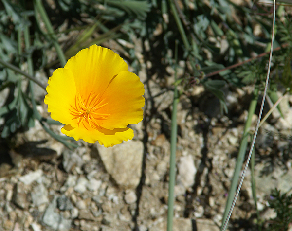 perfectly. Now, all I had to do was find a field of poppies and ask the tin man a questions. I'd heard that he'd started crying out in a field of poppies and had been abandoned by his friends because they'd had enough of his whining. Apparently, he'd cried one too many tears and the rest of his caching group left him to rust away into nothing. Now, I wasn't the one that was going to help this guy out. I didn't know him from Adam, and I'd heard he could wield a mean axe, so I just quickly stepped in, got the information that someone had graffitied on the back of his torso and got out of there as fast as I could. The poppies were making me sleepy and I really didn't want the same fate to befall me as that poor dog lying near the tin man. Or should I say, what had befallen of that poor dog skeleton. Yuck.
The instant I'd found the clue on the tin man, I knew I was in trouble. Apes?? I had to find an actual ape? What was I to do? I'm not the strongest or bravest man in the world and the thought of walking somewhere, where there might be a wild gorilla out and about was almost more than 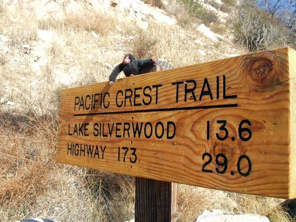 I could handle. However, I'd already failed at this challenge twice and I was further along than I'd ever been before, so I was not giving up this easily.
The big question I had to solve was where to find an ape along Route 66 in the first place. I had all the clues, or at least I thought I did, so maybe I had to look at all of the clues again, just to get a different perspective on the situation at hand. I laid everything out on the ground and realized that I no long was supposed to follow Route 66, but now had a different route. I looked around and realized that I was long yards away from the next clue and lo and behold, there stood the ape, waiting to give me the next clue. I was absolutely amazed that my luck had held on this vicious cache.
After getting the needed information from the ape, I knew I was now going for the final of this excellent multi-cache. It looked like it was just going to be a short half mile hike along this well shaded trail to final cache hidden inside something dead. Great. All I had to do was control my gag reflexes, reach inside a dead body to find the cache. Simple. Knowing that the hider liked to have finders wade across the Amazon, or hike up a snow covered peak, just to find his caches, I knew that I would have to be prepared for just about anything, but a dead body???? Well, I'd come this far for this cache, I figured I might as well continue.
Eureka!! I found the dead body and was able to extract the cache from its hiding spot. I have to tell you, I wasn't the first to find on this one, but it felt like it. I could 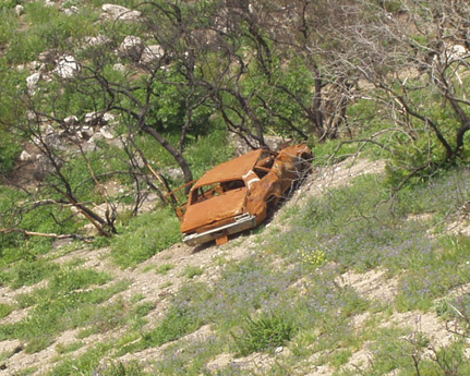 not believe the amazing things that were in this cache. It was hard to decide what swag I would take from this cache, but I eventually decided that the certificate for a day as Secretary of the Treasury was well worth the price I'd paid to find this most excellent cache. Now, I had a major decision to make. How could I possible trade at least even? Hmmm. I decided that two field tested bazooka launchers and a signed picture of Elvis and Richard Nixon was well worth even money for what I'd taken. I hope the next finder would enjoy any one of these items.
Now, it was just a hike back to my car and the long drive home. All the while I kept thinking to myself, "self, that was a most excellent cache. You'd better come up with a decent log for this one." Yeah. The log better be decent. It's probably my only two word log that I've ever written for any cache this good. It simply stated, Loof Lirpa.
Pictures were taken at or near the following caches:
Sum of All Fears - by Mr. and Mrs. Rhino
Route 66 - The California Route 66 Museum - by Parsa
Buchy Boy's Final Resting Place - by FullOn
The Mystery of Crowder Canyon - by Tevis Clan
Double Barrel Super-Soaker - by ohgr
