Last week, Chaosmanor and I went up into San Francisquito Canyon to do some geocaching. One of the caches we looked for was the earthcache, 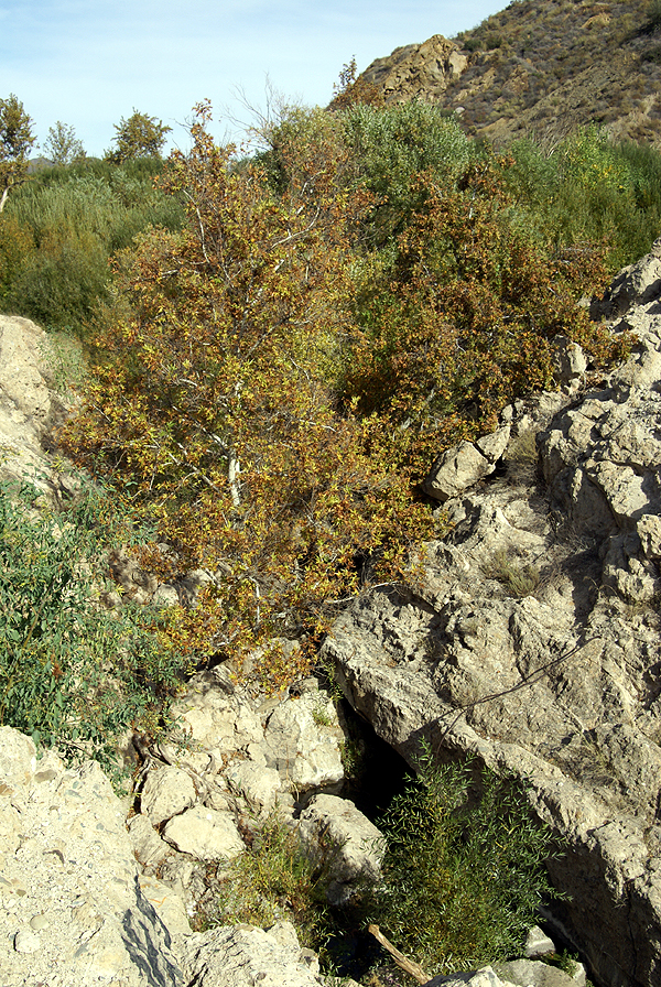 St. Francis Dam Failure, Saugus California. Obviously, the earthcache has you examine some of the things that led to the failure of the St. Francis Dam, back in March 1928 over 80 years ago.
As noted previously in my last post, the road used to lead right past the dam site, but the dam, or what's left of the dam is now shielded from the new road course. I don't believe this was done intentionally, but we both noticed that you cannot see the dam either coming or going along the new course of the rive. Well, I take that back. You can see the dam as you make your way south out of the canyon, but only if you really know what you're looking for, which probably leaves most of us out.
The dam was constructed between 1925 and 1926 and then was slowly filled over the course of the next couple of years. It was designed by William Mulholland, the chief architect of the Los Angeles aqueduct that brings needed water to the city from Owens Valley along the east side of the Sierra Nevada. This reservoir was designed as one of the storage sites for that water.
As the dam slowly filled, cracks and leaks were noticed in the face of the dam, but they were pronounced normal for the dam by Mulholland. As the lake increased behind the dam and more pressure was exerted on the dam, more cracks and leaks developed, each one being dismissed by Mulholland as normal for a dam of this size. The lake was at full capacity for five days before the dam collapsed, first on the east side, then on the west side leaving a large portion of the 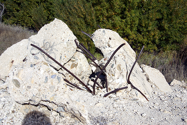 dam upright and standing in the middle of the stream with water flowing around it.
The dam pieces were pushed downstream up to a quarter mile away as the water rushed down San Francisquito Canyon. No one know for sure how many people dies in the flooding that followed. I've seen counts as low as 450 and as high as 600. Those are "official" counts and are also acknowledged as being on the low side because there was no accounting for the migrant farm workers that were living in the area. I also read a report that stated they were still finding bodies as late as the 1970s.
This disaster, obviously ended William Mulholland's career. The geology of the area known in the 1920s was not enough to prevent the dam from collapsing. Newer developments would have been able to see the flaws that led to the collapse of the dam and the dam would not have been built in that particular position in the canyon. As we stood on the top of what's left of the dam, we figured out why Mulholland chose that particular site. It was a natural site for a dam, a fairly narrow canyon that opened up onto a broad expansive valley upstream. The place where the dam was built was narrow and 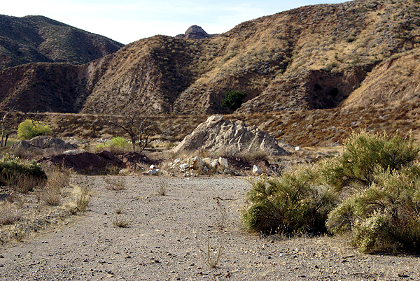 would have trapped a large volume of water behind it. It was just built, geologically, in the wrong spot.
It's interesting that Mulholland admitted he made a mistake and claimed full responsibility, yet there doesn't seem to be any major lawsuits brought forth following the disaster. Perhaps it was because the inquest placed the responsibility at his agency's door, but also stated that Mulholland had no way of knowing the geologic formations where the dam was placed would cause the failure of the dam. I'm pretty sure we would not see the same kind of reaction from the general public if a similar dam were to collapse now. Lessons were learned and have been applied to other dams built afterward, similar to lessons learned when the Titanic sank.
I'll not get into the specifics of the earthcache itself. If you wish to do this earthcache, it's fairly straightforward and easy to do. 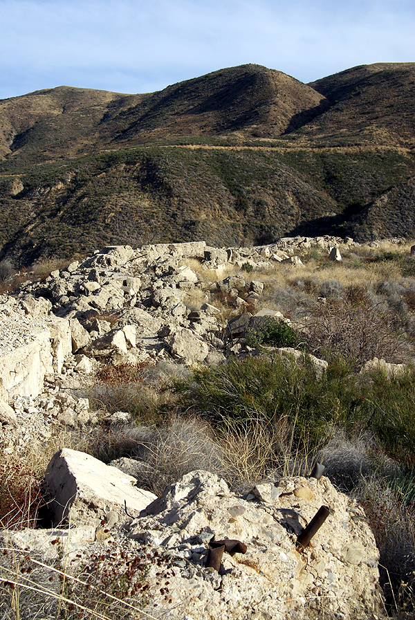 You get a lot of insight into dam building and what caused the failure, plus you can see the raw power of 12 billion gallons of water. The pile of debris in the third picture is pieces of the dam at least a quarter mile away from the actual site, moved there by the water as the dam collapsed.
Another geocache took us up to the top of the western part of the dam that was still there. The middle part of the dam, that was left standing after the flood, was later demolished after someone was killed attempting to climb it. Standing up on top of the dam was where we got to see why the dam was placed there. The broad valley behind the dam was perfect. Had the dam not fallen, I could see where this area would be a perfect recreational area for boaters. This would have been a huge lake.
At the same time, had someone been standing up on the western side of the dam when the other part collapsed, it probably would have been mind numbing to see it happen. It took close to two years to fill the lake completely and it drained in less than two hours. I've seen pictures of people who were standing on the top of Mt. Adams when nearby Mt. St. Helens exploded back in May 1980. One woman just fell to her knees as she watched that drama unfold. I can only imagine it might have been similar here, had there been a witness who survived.
South of the actual site there is a California Historical Marker noting the disaster, but that seems to be the only official noting of the 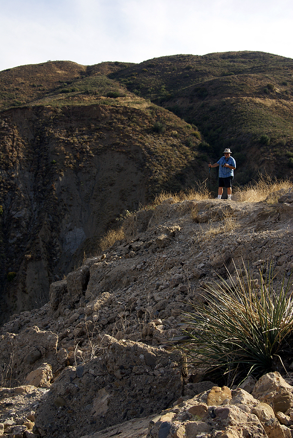 tragedy. The site is in the process of generalized decay. There is still quite a bit to see considering the site is 80 years old. The main portion of the west wall is still intact and accessible from a trail head that starts south of the dam, or from the beginning of a road cut that was made when the newer portion of the road was made a couple of years ago. There are huge chunks of the dam sitting in the middle of the canyon, some with inch thick rebar and rusting pipes jutting out of the sides of these pieces. Smaller pieces of the dam, I'm sure, are disappearing as souvenir hunters comb the area, but the main pieces won't be going anywhere anytime soon. If you get to this area, I highly recommend a side trip up here, just for the historical interest of the site.
It's unfortunate that a disaster such as this has to happen to spur government officials to act in the best interests of the people. That seems to be our way of life. Fortunately, these types of incidents don't happen nearly as frequently as they did earlier in the last couple of centuries. Yes, it was an ugly incident, but some good did come of it, and that is a good thing.
Pictures were taken at or near the following geocaches:
St. Francis Dam Failure, Saugus California - by TerryDad2
In the Shadow of St. Francis Dam - by Yosemite John and Debbie
St. Francis Cache - by Tom and Tommy
Friday, November 28, 2008
St. Francis Dam

Wednesday, November 26, 2008
Mother Nature Reclaiming What is Hers
Several weeks ago, we had terrible wildfires rush through several areas of Southern California. Today, with the heavy rains we've had,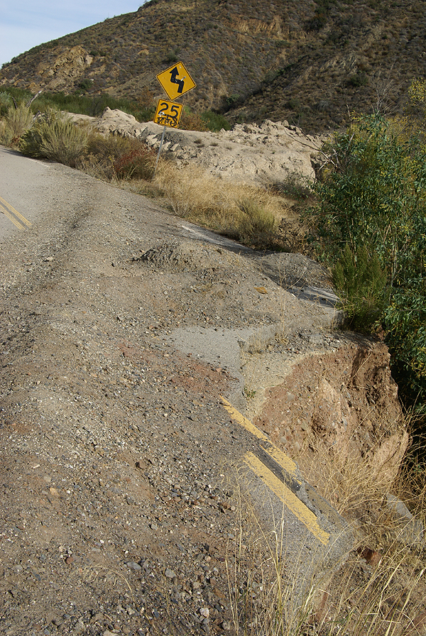 I would suspect that all of these fires are completely contained. I drove through the Santa Ana Canyon, where the Freeway Complex fire was, via Hwy 91 this morning and got a first hand look at the devastation. For homeowners it must have been horrifying. I could see burned spots that stopped right at back yards. Now it's Mother Nature's turn to reclaim that land. Some won't be reclaimed because of human habitation, but areas will slowly turn green again. The Earth will heal itself.
Last Saturday, I found some geocaches along a stretch of road that had been abandoned, due to flooding. The road had recently been realigned around a narrow spot in this canyon, bypassing this particular part of the road. 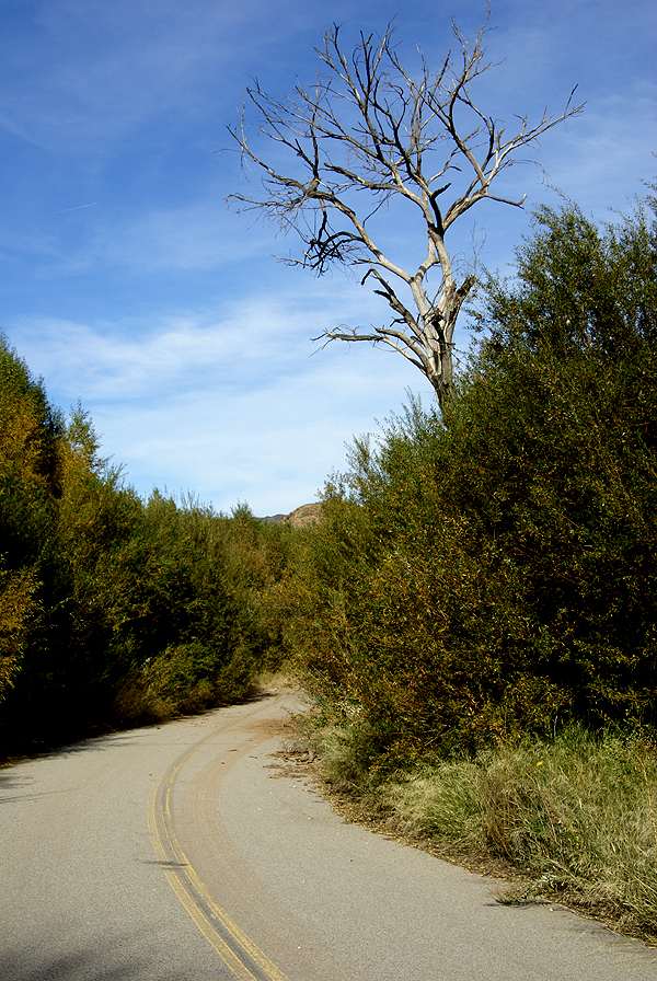 Nature has a way of taking back what is rightfully hers, and it was rather evident at this spot. Bushes and shrubs were encroaching on the road.
Several years ago, we'd had an El Niño year, which means lots of rain. There was plenty of evidence of that, because there were several places where the road was almost washed out completely. Eventually, this area will be reclaimed by nature and the barriers that are there now to prevent cars from driving on an unsafe road will be removed. But for now, it's a work in progress.
As we hiked through this canyon, I was struck by how powerful nature (water, wind, fire) really is. 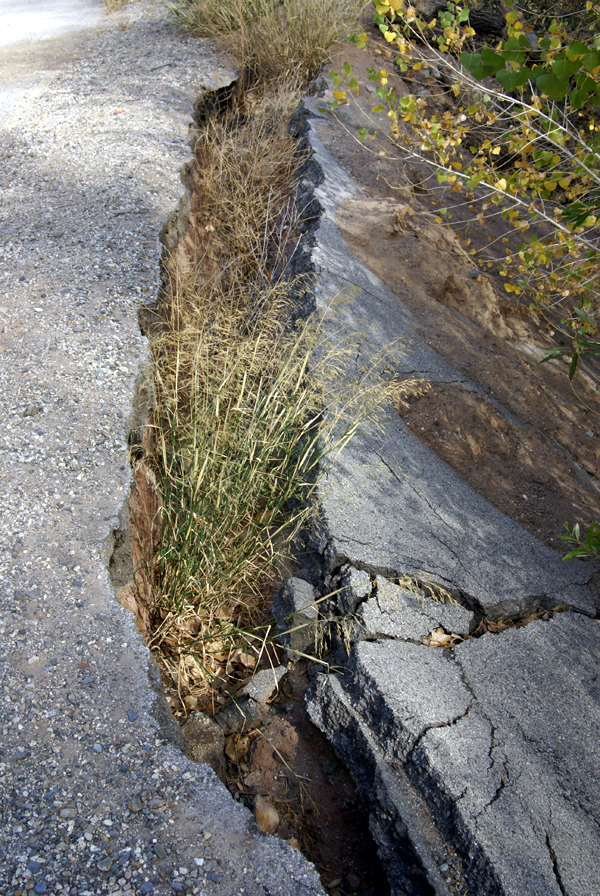 In an instant, a landscape is changed by fire or flood or possibly a landslide. It may take years to hide these "blemishes" as we might call them, but are they really blemishes at all? Probably not. While doing an earthcache in the same area, we were asked to look and find other areas where we could see evidence of landslides along the hillside. I stopped counting after noticing half a dozen. Had we not done the earthcache, I probably wouldn't have thought twice about what I was looking at, yet here was evidence of massive change, that was hardly noticed by most people, because, once again, the Earth had healed itself.
It gives me hope for the future. No matter what we end up doing with ourselves, the Earth will probably survive, rebuild and start anew. A new species will now possibly grab the top spot among the sentient beings on the Earth. But, the Earth, will heal. In fact, it's trying to heal right now. Sometimes, I think we just need to step aside and let the master work.
Pictures were taken at or near the following geocaches:
Reclaimed by Water - by Yosemite John and Debbie
St. Francis Cache - by Tom and Tommy
In the Shadow of St. Francis Dam - by Yosemite John and Debbie

Sunday, November 23, 2008
Red Light Caches
No, this is not about caching in seedy areas. In fact, the area where these two caches were found was very upscale suburbia. Saturday, I went caching with 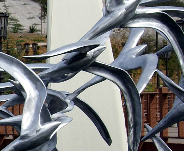 Chaosmanor in the Santa Clarita area. This is where 6 Flags Magic Mountain is located for you roller coaster enthusiasts. We were working our way up to San Francisquito Canyon to drive up the road to get some caching done there and to do a hike. I'd run my PQ around a certain spot in the canyon and Chaosmanor had done likewise and we were in the midst of many of the caches from either PQ.
As we traveled down McBean Parkway, I ended up making several yellow lights and was trying to keep my speed pretty even because it seemed like the lights were timed, so I figured that if I kept it right around the speed limit, we'd make good time and make it to the canyon early. One light defied my timing and I was forced to stop. As we sat there waiting for our green light we noticed two caches in front of us on either side of the intersection ahead of us. As I looked right, I noticed a very interesting sculpture of some birds. I was talking out loud, saying that as long as we're stopped and the sculpture looked kind of interesting, we should check that area out, but I was in the wrong lane, being in the far left hand lane and making it all the way across three to four lanes of traffic would not have been prudent, so we decided to pass on it.
As soon as the light turned green, I had second thoughts again about not getting that cache, so I decided to make a left hand turn into the park on the opposite corner, figuring that I could either back track to it or we could walk over to it. Once the car was parked, we noticed another cache over here in the park, so we decided to check it out as well. As we approached ground zero on this one, I didn't have a very good feeling about it. The place was teeming with muggles of all shapes and sizes. There was a soccer game going on about 20 feet away from ground zero and about 30 feet in the opposite direction of ground ze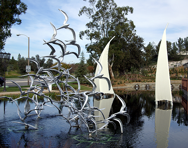 ro was a play area, filled to capacity with mothers and younger siblings of the soccer participants.
This was going to be a difficult find if we were even lucky to find it. Very near ground zero was a life size grizzly bear statue. Now this wasn't just any grizzly bear, as it had a pedestal that was meant to explain why it was there, but it wasn't complete yet. We didn't need the pedestal to tell us what it was all about. The bear's skin was completely made of historical pictures of Valencia, CA, where the statue was located. There were some very old pictures on the left side of the bear and some more recent ones on the other side.
While Chaosmanor was looking at the bear, I decided to make a quick look around to see if I could figure where the cache was located. It was pretty obvious, in fact, you can see the hiding spot from one of my pictures. The trouble was, it was a little awkward, but I got away with it. One thing about muggles is, if you don't linger too long in an area where you're really not supposed to be, they forget about you really quickly. Plus, the one woman who even looked at me, got almost immediately distracted by her charge and quickly had to deal with her little one and so didn't pay me any attention as I went into search mode and quickly found the cache.
The nice thing about this hide was it gave you a reason for being there, which I appreciate considering that most people think a middle aged man looking in the bushes is up to no good. The bear had a lot of historical references on it and we thoroughly enjoyed out time looking over it. Who ever created it actually has a sense of humor as well, placing a picture of the local Wal-Mart right below the bear's tail. After taking some pictures of my own, we made our way to the other side of the street and the sculpture that had attracted us to this area in the first place.
The other side of the street was a business area, but the corner was a dedicated art work. There was a walkway over a nice sized pond that was barren of fish. 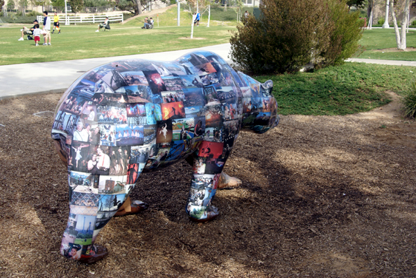 There were several sailboat sculptures in the water as well as a large sculpture of seagulls flying in formation in front of the boats. We got over to the area and I immediately started taking pictures and figuring out where the cache was. I had the cache in hand momentarily and we signed the log and replaced the cache. It was another example of a micro placed in such a way to give the person searching for it a reason for being there.
Too many times, I'll encounter micro caches that make it very hard to search for it because there's no purpose for a person to be there in the first place. Why would anyone hang around a light pole, or walk into a section of bushes? Unless they're working on said stuff, there really isn't a reason and if that lamp post is located in a major muggle area, it makes it difficult to retrieve the cache and then replace it after signing the log. Both of these, the second more so than the first, at least had the cache hidden in such a way that you were supposed to look like you were there. I placed both of these caches on my top 5% list because I liked the environment they were in and I liked the area. They were well planned, quality caches in my opinion.
So this brings me back to my title. Since the only reason we searched and found these caches was because we had to stop, I'm was trying to 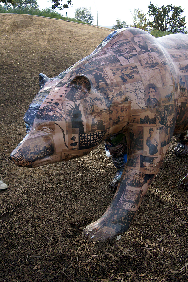 devise a new term for something like these. Red light caches seemed the most appropriate name for them. They make you stop and look because of their surroundings even though you might not have gone out of your way to seek them. Maybe someday, the term might catch on. Usually, I'm not that grateful when I have to stop at a red light, but this time I was. The forty minutes we spent enjoying the atmosphere of the two sites and searching for the caches was well worth the time out of our day. In this particular case, it was like we had stopped and smelled the roses. Every now and then, we all need to do that.
Pictures were taken at or near the following caches:
Bird's Eye View - by ourflyingpig
Heritage Bear - by Ninja Man

Thursday, November 20, 2008
Anticipation...
Christmas is just around the corner. I turned on my favorite oldies station this afternoon and they were playing 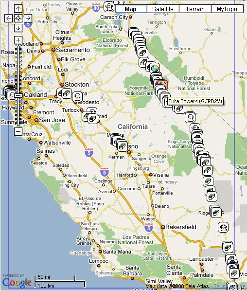 Christmas music and they announced that they planned on playing a lot of it over the next five weeks, thus bringing up the anticipation level even more than it already is I guess. The anticipation level here is a little bit different and it's actually delayed a bit farther into the future.
Part of the fun of anything, whether it be Christmas, your birthday, or a trip of some kind is the anticipation before hand. There's planning to do and things to buy. With a trip, there's the anticipation of seeing new sights, doing new and different things, or possibly visiting places you've been to before and thinking about all the new memories that will happen.
When I went to visit my daughter earlier this month, we broached the subject of me coming up again to visit in February. I have a four day weekend, so I thought it would be a great time to come up and visit, maybe go somewhere and of course, do some caching. We talked about possible day trips we could do that weekend, and we came up with a day trip into San Francisco, with a possible stop at Alcatraz Island, going down Lombard St., touring Pier 39, and maybe visiting Fort Point under the Golden Gate Bridge.
Once I got home, I started to think about this. Usually I go up through the Big Valley, then come home the same way, getting caches both ways. I thought this trip might be fun if I varied my route, to include heading over to Reno, then coming down Hwy 395 through the Owens Valley. This one is pretty much weather dependent and could get snowed out, but I decided that I might as well start the planning process.
There are several caches that I'd like to find on this trip. I could probably make a list that would go on for several pages, but I'll try to limit it to the ones that have some kind of meaning. I guess you could call this adding to my bucket list.
Mazanar Waterworks Virtual Cache is obviously in Manzanar National Historic Site. The place preserves an era of our history that I'm sure many would like us to  forget wen though we shouldn't. I've found another cache already in the park, but I'd like to come back here and check this one out, plus another just outside of the park boundary.
The Monoville "Hunters" Cache was hidden by Snoogans, a friend that I know only through the Geocaching forums. He lives in Texas, but regularly visits this eastern part of the Sierra. This allows him to hide caches that are outside of his normal range, so as to not be a "vacation" type of cache. I think it would be fun to find a cache of someone that I've known for several years. He hasn't found any of my caches yet, but he's found several of my geocoins and travel bugs that have made it to his neck of the woods.
Since I'll be driving by Mono Lake, it would be criminal not to stop and view the Tufa Towers and get the earthcache of the same name. These towers are mineral deposits left over when the lake was at a higher level. The city of Los Angeles bought up the water rights in this area and has siphoned a great part of the water off for its own thirst, but laws are in place that will hopefully prevent the total desecration of this lake. This should be an interesting cache to find. For you cinematic buffs out there, this episode of Los Angeles history is chronicled well in the movie, "Chinatown" staring Jack Nicholson and Faye Dunaway.
Since 395 goes into Nevada, I'd have to get at least a couple of caches in that state as well. 12 Resting Trees, is one of many I could choose from, since it's large and apparently in a good spot to find.
If we do get over to Alcatraz, then we'll have to Escape from Alcataz just to say we have.
At the moment, there are 129 caches on that map that can be found. They won't all be found. I know that, but it's still fun to think about it. As I've gone over the maps, I've looked at many of the cache pages and thought that a particular cache looked interesting and I'd like to find it. Many on this list are like that. We'll see. Snow could close the I-80 and I'll have to come back down by way of Hwy 99. That's OK too. It's a journey, no matter which way I go.
Pictures were taken at or near the following geocache:
Manzanar Virtual Cache - by GoodDogSD

Monday, November 17, 2008
Discoveries?
The first time I saw the mass hysteria over geocoin icons, was at an event several years ago. People had books of geocoins and there were other cachers just  scrambling to write down the geocoin numbers on them. This is all done so that people can get another cool looking "Icon" on their geocacing profile page. And you don't have to look, because I'll freely admit that I have many icons on my page as well. This has all been precipitated by Geocaching.com's use of the "Discovery" feature, where cachers don't have to virtually grab a geocoin, then virtually drop it back into the same cache to get credit for the icon. All they have to do is discover the coin.
I'm pretty sure I know why they did it. It reduces the number by half of emails that get sent out to owners following a discovery. Previously, the owner of a geocoin would get an email from GC.com when a cacher grabbed a geocoin or travel bug, then would get another email when it was virtually placed back into the cache. With the discovery method, less computer resources are used.
However, as an owner of many geocoins and travel bugs, I find the discovery option to be very frustrating. I've been getting a lot of emails lately on several of my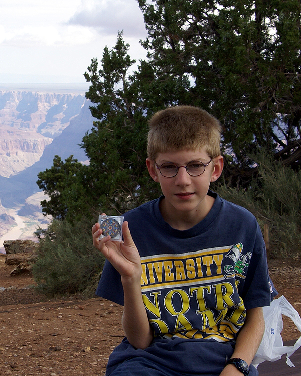 coins that are just discovery emails. I place geocoins and travel bugs in caches so they'll travel around. The problem is the discovery option allows cachers to leave the coins in the cache, get another icon and not have to bother with moving it along. Or, I'll see a comment where the cacher didn't have a trade item so just decided to discover the coin instead.
Geocoins and travel bugs are meant to travel and are not considered swag, or treasure in a cache. Therefore, you don't have to trade something for a travel bug or geocoin. It's very frustrating to see discovery after discovery on some of my geocoins, yet not see any movement. That's one of the reasons I've stopped using the discovery option unless I'm discovering a friend's coin from their personal collection. I'd much rather see my geocoin or travel bug on the move as opposed to sit in a cache for months while people look at it, discover it, and then basically ignore it. I wish GC.com never had thought up the discovery option. I think it would encourage more movement of travelers if they hadn't.
Photos were taken at or near the following geocaches:
Freeway Photo-op - by Zenophile
Mary E. J. Colter built it - by Yrium and Whistlestick

Wednesday, November 12, 2008
Temptations
On Sunday, during our hike to the Vernal Fall Bridge, I casually told my daughter there was another virtual cache further up the trail. She was willing to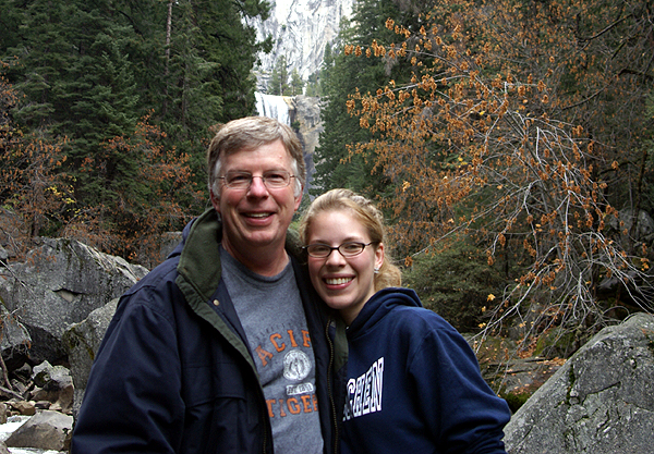 try for it, but it would be another .7 miles of hiking and an elevation gain of over 1000 feet. At that time, temptation set in. I told her that the only requirements for this virtual were that I name the two pools people weren't supposed to swim in near the brink of Vernal Fall.
In other words, this was one of those "arm chair" caches that people refer to that don't require you to be at the actual site to log them. As long as you can come up with the correct answers, feel free to log them. I've always been under the assumption that you had to get to the coordinates to log the find, even for a virtual cache, yet I was surprised that I was thinking about logging this one. All I would have to do is find a park ranger and ask the name of the second pool, since I already knew the name of the first one.
Once we got to the bridge, my daughter was rarin' to go on to the top, but I told her we couldn't make it with the time we had left. By that time, I'd also gotten hold of my senses and told her I wasn't going to log the cache. I told her the next time we're here, we'll get it. It will still be there. So if you look over my left shoulder in this picture, you can see the cache spot, one that I didn't log, because I didn't get there.
I know people log "arm chair" caches all the time, and I guess the answer to my question of why, they would probably say, because they could. I guess I'm taking a holier than thou attitude here, but just because people can, does it mean they should? That's my food for thought for the day.
Pictures were taken at or near the following geocache:
Split Rock: An Investigation - by Warren Harding

Tuesday, November 11, 2008
Yosemite
I started caching before geocaching had its first birthday. All that really means is I've been at this awhile. It doesn't mean I have found the 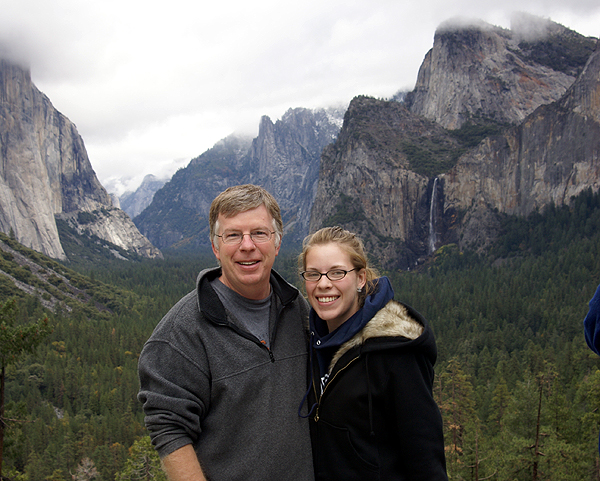 most caches (I haven't) or I've hidden the most caches (I haven't) or even that I'm a creative hider of caches (probably not, but I'll let others decide that).
I first heard about geocaching in all places, a Where's George? chatroom. If you're familiar with Where's George?, you know the purpose of that website is to track your money after it leaves your hands. Anyway, a friend of mine, in that chatroom, had been describing a cache hunt. I was intrigued by this and asked him what the heck he was talking about and he directed me to Geocaching.com. Push came to shove and I went out and bought a GPS handheld unit, and took my two young sons with me to find our first cache.
While perusing the geocaching.com site that first week, I looked at all the possible geocaches that were hidden in the state of California. I noticed there was a cache hidden in Yosemite Valley. Since the hobby was still new, many of the ground rules that we take for granted weren't in place yet, which is why that one was hidden there. As soon as the  National Park Service found out, they quickly put a stop to hiding caches within the borders of national parks. Then for a couple of years, people hid "virtual" caches in many of the national parks, that is a cache, that while not really there, takes you to a spot of scenic beauty or historical significance. There are several virtual caches in Yosemite National Park. This past Sunday, my daughter and I drove to Yosemite and found four of these virtual caches.
When I drove up to vist my daughter this weekend, I noticed that I had found 98 virtual caches, so I figured that one of the caches in the valley would be my 100th virtual find. I found a virtual on the drive up to Stockton, so I only needed one. I figured what better one to find than the virtual that is located at the viewpoint overlooking the valley. We got up early in the morning, had breakfast and then drove into the park. The viewpoint was the first spot we stopped at so we could claim the find for that virtual cache. This particular virtual's requirements were to get information off of a sign or to take a picture of you at the viewpoint. We did both, getting the needed information and finding a leather clad biker to take our picture.
After lunch, we took the shuttle bus over to Happy Isles where we learned about the great flood of 1997 when the Merced River crested at least 30 feet over normal depth. The gauging station in the picture was caught in the flood. What you can't see is the river, which has to be at least 25 feet below my shoe level from where I am standing. To the left of the picture used to be a bridge. It didn't fare so well in this particular flood. The 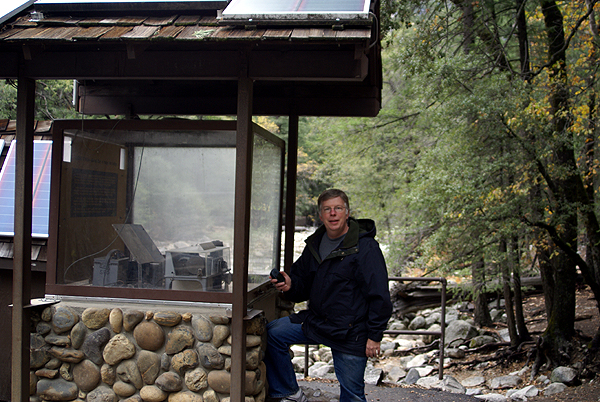 flood also washed away 2 and a half campgrounds, two of which the park is not restoring, to lesson the impact of people on the environment of the area. 11 years later, there are many new pine saplings growing where there used to be nothing but a sea of tents and campers.
Another virtual had us looking at how the rocks in the valley weather over time. We did a hike from this point up to a viewpoint looking up at Vernal Fall. From the trail, we could look across the valley and see the Upper Yosemite Fall, one of the highest waterfalls in the entire world, dropping over 2400 feet. The hike up to the Vernal Fall Bridge was steep and strenuous. For some reason, I don't recall it being that steep before. I guess that's the perils one faces as each of us get older; the trails get steeper and longer at the same time. Needless to say, it was a nice aerobic workout for both of us as we hiked almost a mile to the bridge.
One thing about caching is you don't normally hide a container out in the open in the middle of a field. It's too easily found by non-geocaching people that way. The normal way would be to 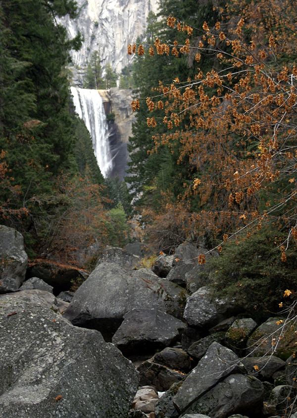 hide the container in the forest, behind a rock or tree, or under a bush, some out of the way place. The beauty of a virtual is that it can be hidden anywhere. One virtual that we found was the Nose of El Capitan. This particular cache took us out into a meadow so that we could get an interesting view of El Capitan, the largest piece of solid exposed granite in the entire world. I liked this particular cache because it got me out of my comfort zone a little. I've visited Yosemite probably close to 20 times, yet have never stood in this meadow and contemplated the vastness of this piece of rock. This virtual got me to do that.
With Yosemite, you don't really need a virtual cache to get you to most of the spots we visited. Two of the spots, we would have visited anyway, but we did learn some new things and got to see some of the things from a new perspective because of the virtuals. I was able to take some nice pictures to go with some of my logs and was fortunate enough to get my picture of Yosemite Fall picked for the large banner display on the front page of Geocaching.com.
There are many virtual caches in Yosemite. We found four on Sunday. That means we'll be back, probably many times, 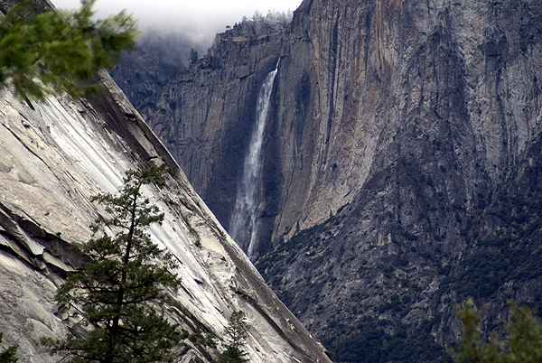 because even if we find all of the virtuals, the park still has its hooks in us. It's one of those magical places of which you really can't get enough. The last time we'd visited Yosemite was 2000. I just hope our next visit is sooner than 8 years in the future.
Pictures were taken at or near the following geocaches:
Out of the Darkness, into Yosemite Valley! - by Dave W6DPS and son
The Nose of El Capitan - by Warren Harding
A Happy Place - by Russell Grove and Warren Harding
Split Rock: An Investigation - by Warren Harding

Mission Accomplished!
"Your mission, should you choose to accept it, is to distribute 18 travel bugs and/or geocoins in geocaches in the next three days. This tape will self destruct in 5 seconds."
That's sort of what it felt like after getting a corn dog box filled with travel bugs and geocoins. I was up to the task and made sure I had plenty of large geocaches with which to choose to make sure I was going to be able to leave them all on the road and not bring any home. It should also be noted that several caches that were labeled "regular" wouldn't even hold a geocoin. There should be some kind of truth in advertising law on caches.
1. Oops. I cheated and left a geocoin before going on the trip at Behind the Bullseye.
2. Left a geocoin in Fly Me Away.
3. Left a Mardi Gras beads travel bug in Notta Ammo Dump.
4. Left a Key travel bug in No Pallets Here.
5, 6, & 7. Left a travel bug, a white Jeep, and a geocoin in Delhi Delight.
8 & 9. On our way into Yosemite National Park, we left two travel bugs in Yosemite Junction Geocoin and Travel Bug Hotel.
10. Left a geocoin in Monkey Hear.
11 & 12. Left two travel bugs in Reading Rocks!
13. Left another geocoin in Monkey Do. I didn't get a chance to find Monkey See.
14 & 15. Left a geocoin and a geocoin replica in Don't Peek On Me!
16. Left the largest key ring add on that I've personally seen in Erling in the Morning. I also left the Pushawalla Traveling Cache (Traveler Tag #TEDA8).
17 & 18. In an appropriately named cache, Zenobia's End, I left the last two travel bugs in the last cache that I found on this trip.
Mission Accomplished, cue the music.

Wednesday, November 5, 2008
A Great Excuse for Caching
As previously noted below, I'm heading out on the road this weekend. I plan on leaving Saturday morning which will get me up to Stockton in plenty of time to hear my 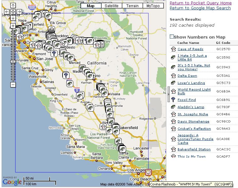 daughter play in her college orchestra Saturday night at 7:30. I don't plan to set an alarm, but I'll probably get an early start. At one time, I thought about hitting the Flash Mob Event that's happening in Covina at 10:00 in the morning, but I'm pretty sure that I'm going to miss it this time. The Tadpole and I went to a Flash Mob Event last year out in the Coachella Valley and then went caching in and around Joshua Tree National Park. It was a fun day, but we didn't have any kind of agenda except to make sure we were at the Flash Mob Event at 9:00 in the morning. This year's Flash Mob in Covina isn't starting until 10:00 in the morning, so that could cramp my caching later on since we don't have a lot of daylight to work with this time of the year plus I need to be in Stockton around earlier than 7 so as to not miss the concert. Unless I get a really late start out on Saturday, I'll probably bypass the Flash Mob this year.
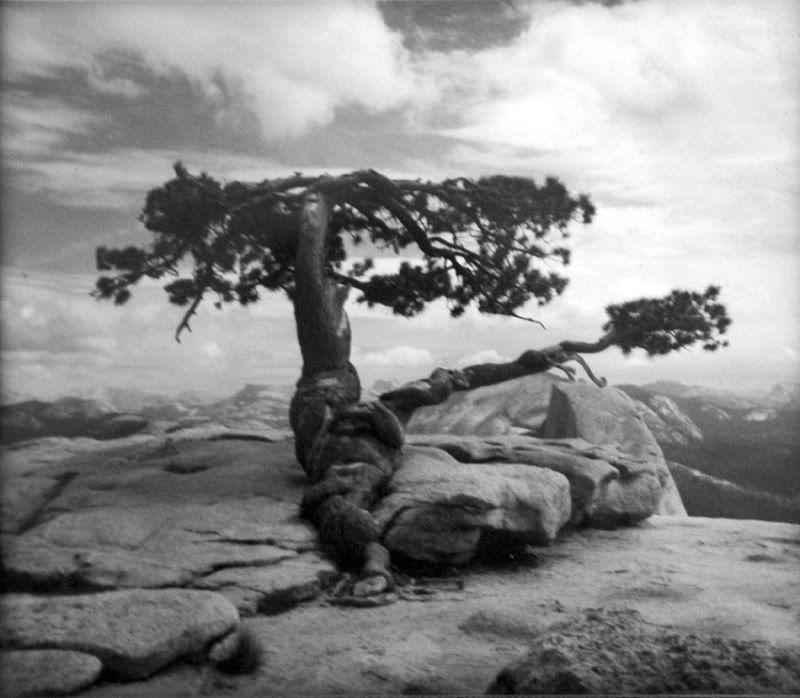 As you can see by the screenshot I took of my bookmarked PQ, I'm taking a roundabout way when leaving Stockton. Getting there will be pretty straightforward, heading out the 210 from my place, then connecting up with the 5 and then taking the 99 to Stockton. The 99 is a little bit longer, but it's a lot more scenic and has many more caching opportunities along it as well. Almost all the caches along this route are listed as small or larger. I'm going to go through the list and make sure I know exactly where the really large ones are so I don't miss those. I have a lot of travel bugs and geocoins to deposit and I want to make sure they all get distributed this weekend.
Sunday will be devoted to a day trip to Yosemite National Park. There are quite a few virtuals there and we'll get many of them on this trip. We're hoping the snow level is still high enough that the road to Glacier Point  hasn't been closed yet. As of last Friday it was still open, but that could change on a daily basis. There's a hike there up to the top of Sentinel Dome that we'd like to take, not to mention the view from Glacier Point should be spectacular this time of year with all the snow in the high country. The Yosemite Sentinel Dome Virtual Cache plus this benchmark are obviously at the top of Sentinel Dome. There used to be a gnarled Jeffrey Pine tree growing at the top of Sentinel Dome, but it died during the drought years of the late 70s. A couple of years ago, the dead tree finally came tumbling down. On my wall in my bedroom, I have a black and white picture of this tree that I took in 1975 when it was still alive. I went back with my three children in 2000 to pay a visit to it and it was a very sad reunion, since only the trunk and a few branches were all that was left of the tree. Now those remnants aren't there anymore, so the view should be a little different this time if we get up there.
The benchmark is also interesting because the tree is one of the main reference points for the benchmark. The benchmark also refers to a road that leads you to the base of the dome. That road hasn't been there in decades. Every time I've been to the Sentinel Dome, I've had to hike about a mile and a half to get to the dome's summit. There are still areas on that hike where you can encounter the old road, but I have to assume the road was taken out for environmental reasons, probably to reduce the strain on the Jeffrey Pine living up there as well as the other plants living around the base of the dome. Either way, I'll be taking some good notes for this particular benchmark so I can post a log with the National Geodetic Society.
On Monday, I plan on making my way north to Sacramento, getting a dashpoint southeast of the city. Since I'm going to be up there,  I figured that I might be able to get some caching done in some counties that I've never cached in before, like Yolo, Solano, Napa, Sonoma, Marin and Alamede Counties. The route I plan to take is the circular route around the top of San Pablo Bay northeast of San Francisco. Some of the caches there are ones that I'd planned to find this summer but wasn't able to so that will be kind of nice. Once I get back to the 5, I'll probably take it quickly home since I figure that detour around the bay might take up most of my morning.
Over the past couple of years, I've been taking more of these kinds of road trips, mainly because the kids are getting older and they've wanted to start looking at colleges, but also it's been a great excuse to visit my daughter now that she's away at school. Next year, my son starts his road to college, so I'll probably get to go on more of these kinds of trips. Visiting my children is always topmost on my mind on these trips, but they're also a great excuse to get some caching in as well.

Sunday, November 2, 2008
Bevy of Baubles
Dictionary.com defines a bevy as a large group or collection and baubles as a small, showy ornament of little value or a trinket. Last 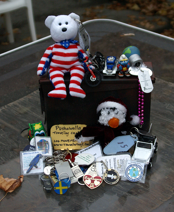 Monday after a physical therapy appointment in the area, I stopped by Losel2's Trackables WayStation Cache in order to pick up a couple of travel bugs to take with me on my road trip up to Stockton next weekend. He'd read on this blog that I was making the trip and no one had been by the cache since October 6th, so he asked if I could help him out with some movement of a couple of bugs. I said no problem.
I got to the waystation and he was there waiting for me, with a big box of corn dogs. Well, it really wasn't corn dogs, but the outside of the box said it was corn dogs. Inside were travel bugs. Let me say, inside were a lot of travel bugs and geocoins, exactly 15 in all. Yep, I have quite a bevy of baubles to deposit in caches along the way next weekend. Since most of the caches that I have on my PQ at the moment are small to large sized caches, it shouldn't be too much of a problem. I know of at least four travel bug hotels that I can deposit bugs in, plus a couple of other caches that should be large enough to handle at least a geocoin. There is also a traveling cache, but it's not associated with geocaching, but I've logged it at travelertags.com.
As you can see by the photos, there are all sizes of travel bugs. Two are rather large beanie baby type of animals, one a bear and the other a penguin. Those will have to go in ammo cans, so they'll be the first to leave the box once I encounter an ammo can on the road. One other large travel bug is a key chain travel bug that has b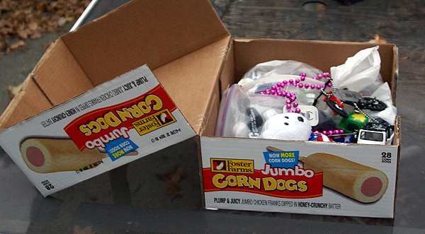 een collecting key chains along its travels. It has to weigh at least 2 pounds and has traveled over 15,000 miles since being released in August 2005. There's a white Jeep that I already had in my possesion, plus a small tech deck bicycle. The rest of the travel bugs are Hot Wheels types or smaller which should be easy to drop into caches that I find. If you look closely, there is a Smurf sitting on top of the ammo can. That one wants to visit the Pacific Crest Trail. I won't be able to get it to the PCT, but since we're headed to Yosemite National Park, we can get it close to the John Muir Trail, at least for picture possibilities. With this many different travel bugs, I should have some interesting possibilities for pictures on this trip. Hopefully, I'll be able to drop them all over the course of the three day weekend.
