Sunday, October 25, 2009

Tanks

Yesterday, the Tadpole had a cross country meet at the Mt. Sac Invitational Cross Country meet, one of the premier running events in the country.  I decided that I could cache in the area with my friend 3blackcats and then head over to Mt. Sac to watch him run.  Unfortunately, he woke up not feeling well and so didn't run, so most of my day was spent caching.


We found a number of interesting caches in the area and had a pretty strenuous hike right after lunch.  We were trying to find one cache, but couldn't find a way in, so headed to the next cache and missed a small cutoff trail that would have led us right to the cache.  We didn't realize that was happening until we'd gotten all the way to the top of the hill.  The trail kept switchbacking on us, taking us tantalizingly close, them drawing us away so we thought we were on the right track.  It wasn't until we got almost to the top that we realized that we were finally walking away from the cache.

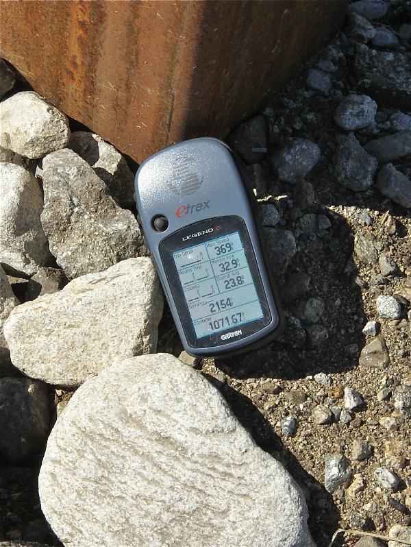
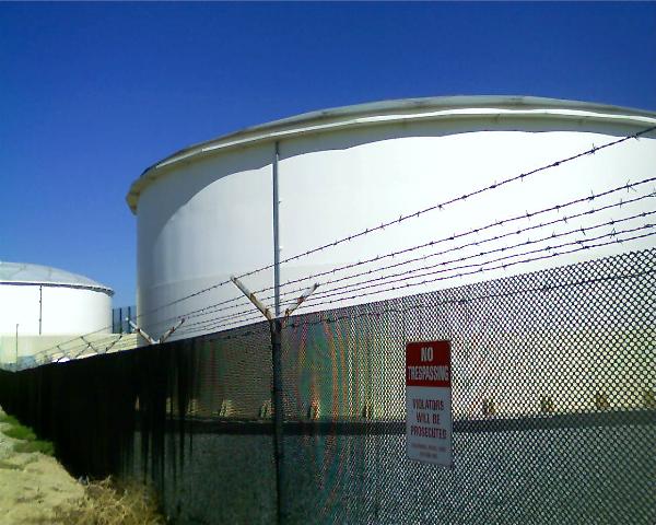
A quick check of the GPSr showed that we were 21 feet away from another cache which we found.  We were also very close to a couple of water tanks, which I took pictures of figuring I could waymark the water tanks in the water towers and tanks category.  There was another cache just beyond the tanks, so we ended up going over to that one as well.  There were some nice house up on that ridge with views of two different valleys. Talk about multi-million dollar views.


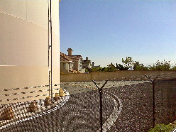
On the way down, we ended up finding a way into the original cache we'd started out to find.  So, in retrospect, it wasn't a bad idea to go after that one cache.  We ended up getting two extra bonus caches because we couldn't get to the first cache right away, plus I was able to waymark those two water towers.  It was a pretty good day.

Pictures were taken at or near the following geocaches:
El Gordo - by UNCLEJON91
You Can Start Here - by UNCLEJON91

Profile for Webfoot

Sunday, October 18, 2009

GPS Accuracy


Yesterday I was able to get out and hike.  There's a new preserve in the north part of Etiwanda with hiking trails in it and I wanted to see what it was like.  Last weekend would have been a better weekend to go because of the weather, but I was busy then.  We had rain earlier in the week, but it's been in the 90s the past couple of days.  Since the Tadpole was just going as a spectator to his cross country meet this weekend, it was the perfect opportunity to get out and cache.

I took him to school to catch his bus, then came back home, loaded up the GPSr, grabbed the gear that I needed and drove the 15 miles over to this preserve.  In the link I provided, the pictures show at least 4, possibly five, cache sites that I visited yesterday.  I found 12 caches yesterday and DNFed 5 others, of which I'm relatively sure that 4 of them are there.  I just didn't do a good enough job of scouring the area to get the cache.


The preserve's main loop trail is 3.25 miles in length and has mile post markers every quarter of a mile.  Each of these markers also have elevation listed on them.  Now I know that GPS accuracy can vary greatly depending upon where you happen to be, but this marker was out in the open without any kind of tree cover or interference, so I figured I'd get pretty good readings and as you can see I did.

Since I posted several DNFs out there yesterday, I expect to be back in that park again.  There were other spots to hide caches on the trail.  Had I known a little bit more about this park, I might have been tempted to bring a cache with me to hide.  I might still do that since I found several nice spots along the trail where a cache would probably do well.

Pictures were taken at or near the following geocache:
NEP #12 - by the4dirtydogs

Profile for Webfoot

Monday, October 12, 2009

Archiving Caches

Yesterday, the Tadpole and I hiked into the Claremont Wilderness Park, which is located in the foothills north of our house.  Most of the caches we've hidden are in and around this park, which has a nice five mile loop trail through the heart of the park.  The fall, winter and spring are definitely the best times to explore this park and all of its side trails.  Being situated in Southern California, the vegetation is somewhat sparse and there isn't much shade on the upper elevations of the trail, so it's a very hot walk in the summertime.  It's getting pleasant right about now in the park.

Our main purpose for heading up into the park was one of my caches, Scenic Value.  I hid Scenic Value on New Year's Day 2007, so it's been around for almost three years.  I'd gotten a couple of DNFs on the cache, but that wasn't unusual as it was hidden deep in a scrub oak tree and difficult to find.  I'd even had a hard time finding it once when I went up to check on it another time.  I wasn't too concerned when the first DNF showed up mainly because it was a new cacher and I figured it just might have been overlooked.  When an experienced cacher later also DNFed the cache, it was time to check it out.

I was actually surprised when the Tadpole and I got up there and couldn't find it.  I'd brought another cache just in case, but after getting to the site, decided against replacing it.  There was a lot of evidence of erosion and the starts of a bushwhacking type of trail leading up from the canyon below.  One of the finds on the cacher had even mentioned about coming up that way.  That was not something that I really wanted to promote, so I decided to archive the cache.

Just down the trail from Scenic Value is a small spur trail that would be a nice spot to hide another cache.  There had been a cache there previously but it had been burned out and either washed away or buried during a subsequent rainstorm.  The area has recovered nicely following the fire and could have a cache placed back in that side canyon.  I'll have to check that out in the near future and decide whether another cache in that general vicinity would be a good idea.

If not, then I'll leave the area alone.  Not many other cachers hide up there, so it will probably stay cache free for the foreseeable future.  That might not be such a bad thing.  It'll end up just being a nice open area along the trail in between other caches.

Pictures were taken at or near the following geocaches in the Claremont Wilderness Park:
Where is the parking lot? - by Mazingerzz
Scenic Value - by Webfoot

Profile for Webfoot

Saturday, October 10, 2009

Southern California Rarity

When you cache in Southern California, you get used to see things a certain way and when things end up differently, you sometimes do a double take.  At the minimum, you stare and try to make some sense of what your seeing.

This was the case when I dropped my son off at Santa Cruz last month.  I ended up traveling south along the 101 through the Salinas Valley.  Driving on the freeway doesn't afford you much time to really look at the scenery and because of its location, you really can't see down into the valley very well either.  However, when I ended up on a side road looking for a couple of caches, I noticed the Salinas River, flowing with water.

Looking at a map, this one is fed by coastal mountain streams, which in late September would be very dry as the rainy season has been pretty much done since mid-March.  Lake Nacimento reservoir also feeds this river, so either the powers that be had an abundance of excess water, or they were letting water go in anticipation of the upcoming wet season a few months down the road.  Either way, it made for a very pretty pastoral picture of the Salinas Valley.

Picture was taken at or near the following geocache:
Binary Blues - Black Gold - by Just a Short Walk

Profile for Webfoot

Thursday, October 8, 2009

Travel Bug Pictures

A year and a half ago, I made a confession that I haven't been very good about maintaining even to this day.  I feel I've done a much better job about taking pictures of the different travel bugs that I've had in my possession, but I'm still not at 100%.  At this point, I'm not sure that's possible.  In my opinion, some travelers don't lend themselves well to photographs.  I think this is especially true with geocoins.  Geocoins area small and difficult to get into focus with the other aspects of an area that the coin is going to be placed.

Many travel bugs are the same way, however, I've found some larger ones are much easier to photograph than others.  I found Arthur up in the high desert this summer and took him up to Santa Cruz with me last month.  I got a good picture of him holding another travel bug when I first found him in the desert and also got a nice photo of him standing in the leaves of the World's Largest Artichoke.

I'd seen this particular virtual on our drive up, so I made it a point to stop on the way down. I got there too early in the morning to partake in some of the nearby restaurant's finer artichoke cuisine, but I was able to stop at a local farmer's market and buy some artichokes to bring home.  10 for a dollar was a bargain price, even for some on the small side.  I think back now and I should have purchased 20 at that price.  Although I suspect the season will be over by the time I get up to Santa Cruz again, probably in late November, but if they have them available then, I'll buy some more.

Getting back to travel bugs.  During that desert run, I also took, what I thought, was a rather whimsical picture of the R2D2 travel bug that I found near Point Reyes National Seashore in July.  The spot where we found a nice travel bug hotel had some rock formations similar to what one might find on the fictional planet of Tatooine in the STAR WARS movies.  Those kinds of pictures are the kind that trigger musical responses in my head.  When I look at that picture, I can hear John Williams theme of the robots walking through the desert on their way to capture by the Jawas.

At the moment, I have three travel bugs sitting on my desk.  I have a geocoin in the shape of a head of lettuce.  "Lettuce go caching."  There's also a Triceratops and a bison tube that I thought was a traveling cache when I first picked it up, since it had a log sheet in it. It's particular goal is to travel to different countries and have the person who placed it in a cache write the name of the country on the log sheet inside.  I'm not sure where this one is going to end up, cache-wise, but at least it's closer to another country here than where it used to be farther north along the 101.

Pictures were taken at or near the following geocaches:
The World's Largest Artichoke - by ynots4
Mojave Green Travel Bug Motel - by The Dananator

Profile for Webfoot