Last October, I hiked in the North Etiwanda Preserve (NEP) for the first time. It was another instance of geocaching getting me to explore something in my own back yard. On that day I found 12 caches and DNFed five of them, a very high DNF rate in my opinion.
For whatever reason, I kept having difficulty finding some of the caches I was looking for that day. 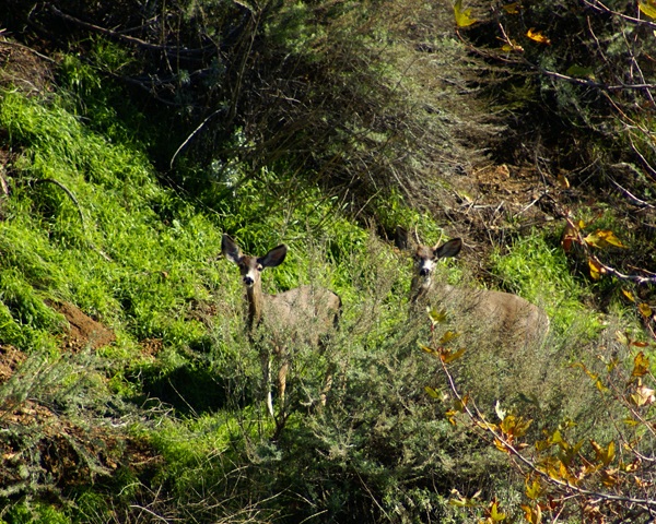 It wasn't because of tree cover, since there was little tree cover around. I just couldn't find them. Yesterday, I went back out again to hike that trail for several reasons, one of which was to rectify those DNFs. There were several new caches along the trail as well, the weather was beautiful and I had cabin fever.
It has rained for most of this vacation and I really haven't been able to get out and do any kind of hiking this past couple of weeks. The weather was finally cooperating and I was going to take full advantage of the situation. The NEP provides a 3.25 mile loop trail, but with spur trails you can walk a lot longer. I ended up walking just over 5.6 miles for my morning hike, with an elevation gain of over 2000 feet.
Fortunately, the gain was very gradual, so it didn't seem like I was gaining much in elevation, yet every mile marker post I came upon, it told me I was climbing. Had I gone the other way on the loop, the gain would have been steeper and more intense, but I knew that from the last time I'd hiked the loop.
With the mountains as a backdrop, I was able to get some really good pictures, more than I can probably post here in three different post, so I'll have to post them gradually over the coming weeks. There was a lot of snow on the peaks, which top out at around 8800 feet. I was hiking at 2300 to 2500 feet above sea level so you can see there's quite a bit of snow on the mountains. Last night, the overnight low got down to 29˚, which is quite cold for our area, which also means that the snow will stay there for awhile.
The daytime temperatures were warm enough that I was able to hike in shirt sleeves yesterday. That also means that once again, people back east will watch the Rose Parade out here tomorrow and see people enjoying the wonderful weather and wonder to themselves why they live in the snow. 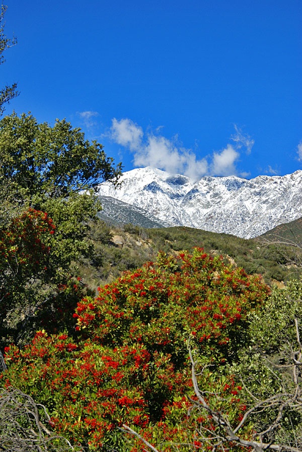 I think the single best advertisement for Southern California year after year is the Rose Parade and to a lesser extent, the Rose Bowl. Only once since I was born has it rained on the Rose Parade. That's a pretty good track record.
Needless to say, I enjoyed the weather yesterday. The setting was perfect for a good hike and for some caching. I was able to find those caches that I couldn't find over a year ago, plus all of the others that I had planned to find. I saw several deer, one that crossed right in front of me on the trail and two others who watched me warily from a good distance away. It was a good day, one that was a fitting end to the old year of 2010.
Tomorrow begins a new year, one that I'm sure everyone hopes will be the best year ever. Resolutions will be made and some will be kept. I resolve to continue to have fun while geocaching. I found more geocaches this year than in any past year. It's quite an achievement, especially since I was out of commission for several months due to personal reasons. I was just lucky the rest of the time I went caching I guess.
I will not resolve to find a certain number of caches. In my opinion, resolutions should be self improving. Finding more caches next year, does nothing to improve myself I believe, although it will probably get me on the trail more so I guess I can resolve to continue to be more physically fit than in the past.
I also resolve to post more often here. As I look back to when this blog was started, I can see my post counts fall every year. 116 in 2008, 100 in 2009 and only 80 this year. I plan to reverse that course this year. And so to all of my readers out there, please enjoy tonight, make it safe and may 2011 truly be the best year ever.
Pictures were taken at or near the following geocaches:
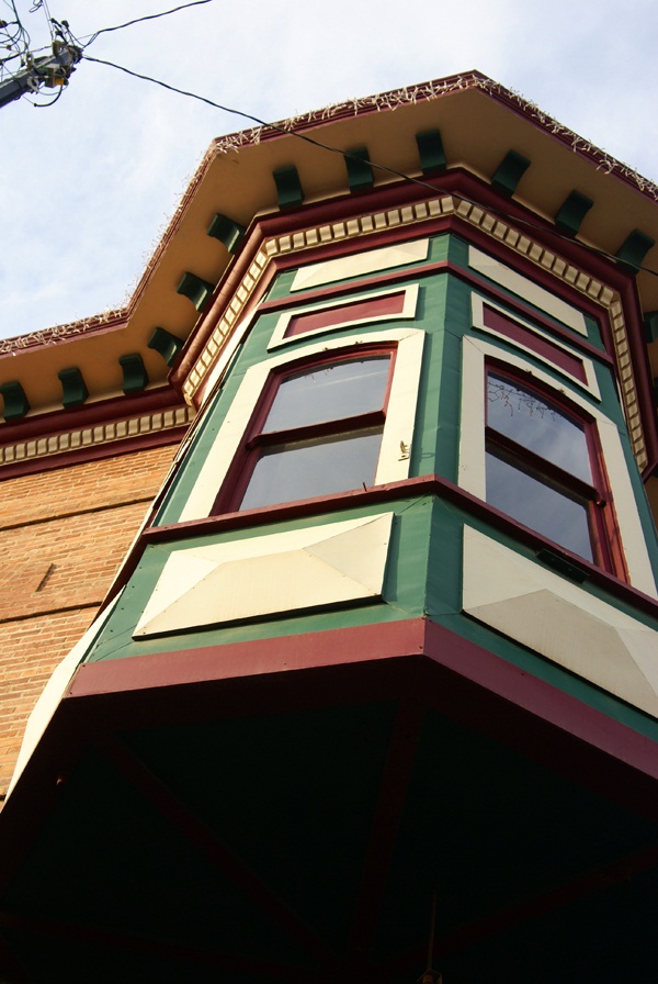
NEP_pd4 - by Ranger Rick
Washed Out Plumbing - by bustindustin
Friday, December 31, 2010
Finding caches I couldn't find

Wednesday, December 29, 2010
More than I can chew
Earlier this month, I mentioned that I was going to attempt the 365 project. I figured that I'd start the project on the first of next month and just end up taking a picture every day for the next year. Already, I now know, I've bitten off more than I can chew.
I uploaded two pictures earlier this month, just to see if this project would be difficult.  In one sense, I can see where I could do this, but in another sense, I know myself well enough to know that I won't be able to do this every day over the next year. I love taking pictures, but at the same token, I'm also a perfectionist. I will not publish a picture of my toenail just to satisfy a daily challenge. It would get onerous very quickly.
Several years ago I challenged myself to try and find a cache for 33 consecutive days. At that time, I was the main person picking up the Tadpole from his elementary school. Because of when his Spring Break was and my Spring Break, I figured there was going to be a 33 day window where it would be relatively easy to find a cache every day during that period. And so I attempted it.
Once the 33 days went by, I continued finding caches each and every day. Some days were relatively easy, while others were more difficult to accomplish but I persevered up until day 57. That day, I ran into a string of caches that I couldn't find and it became frustrating enough after five DNFs that I just said to myself, enough. I wasn't having fun anymore, so I ended the streak. There is no way I'd ever want to attempt any kind of consecutive streak again. I think the longest streak I've had since that time has been 11 consecutive days.
And so I thought I'd be able to take a picture every day for 365 days. Uh huh. Right. The nice thing about the 365 Project is you can upload pictures to specific days. It doesn't hold you accountable for an every day post. So this project will take several years to achieve fullness, but I can live with that. The quality of the pictures will be much better than if I ended up taking a picture every day and I will also continue to enjoy the project as it develops.  I know myself well enough that if I were to attempt this, I would end up hating it in the end. I don't want to do that.
In the meantime, from time to time, I will post updates of my progress on that project. I've noticed many other bloggers contributing to their own blog by having a Wordless Wednesday every week, which just includes a title and a picture. I may end up doing something like that as well, although the way I like to write, actually having to have a wordless day might be painful to me. But I can always try it and if that doesn't work out, so be it.
The two pictures posted here are the two I've posted thus far this month. One is of an inch and a half long millipede we spotted out in the desert the week before Christmas Day. We actually saw two different ones, but this one was a little bit more cooperative than the other. The second picture is of our California Desert Tortoise (yes, I have a permit for it) that lives in our back yard. It came out of its burrow on Christmas Day and was sunning itself under one of our orange trees. Today is the first day since Christmas where I haven't seen it wandering around in the back yard. I suspect the rain today had something to do with that.
Please enjoy these offerings and others in the future.

Friday, December 24, 2010
Sobering thoughts
Whenever I go geocaching, I'm always on the lookout for memorials. There is something about memorials that deeply touch me, especially soldier memorials.  Perhaps it's because I was lucky and was never forced to serve. Each of us must choose our own paths and mine didn't follow a military path, although it's not because my parents didn't try to influence me in that direction. I just knew in my heart that the military life wasn't for me.
But for many men and women, it is their choosing and I salute them for it. It must be extremely difficult to be away from your family during the holiday season. I can't imagine being thousands of miles from home, away from my family, let alone having these conditions imposed upon me and also being shot at in the process.
I've made it my custom, when I come upon a soldier memorial to take as many pictures as possible. The memorial is a poignant reminder of those who never come back from those far distant lands. It reminds me of the family left at home grieving for their lost husband, son or Daddy. It reminds me that I have been truly blessed to live in a country where we value freedom so highly.
A friend of mine is serving in Afghanistan right now, away from his wife and children. A former student of mine was killed earlier this year over there one week before his 20th birthday. 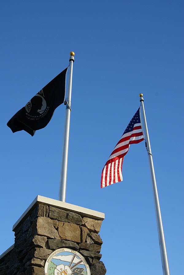 My niece's husband served in Afghanistan several years ago and is now safely home. My nephew serves on a carrier in the Pacific. His carrier group was scrambled last month when North Korea decided to bomb a small South Korean island. At the moment, he's on leave and is safely home in California celebrating the season with us, his family. My thoughts and prayers go out to all of these people and many others who I don't know.
I leave you with a You Tube video that a friend of mine posted earlier today on Facebook.
I know we will always have soldiers overseas, but hopefully next year, we will have fewer of them in harm's way.
Merry Christmas to all, and to all a good night.
Pictures were taken at or near the following geocaches:
Cricket's Reflection - by GeoCrickets
"United We Stand" - by Lizard Man

Monday, December 20, 2010
Here I go, There I go, Where I go
Last month, while on a road trip to Stockton, Chaosmanor and I were fortunate to attempt a couple of Wherigo caches. A Wherigo cache is similar to a multi-cache in that you have to find clues as you walk along a route planned out by the cache hider. You need a Wherigo enabled GPS unit in order to complete a Wherigo cache. 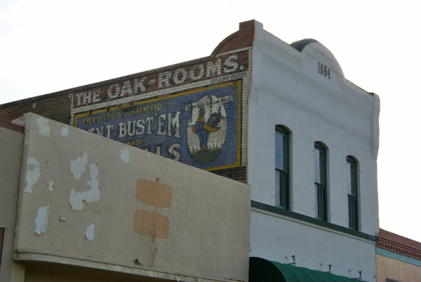 The Geocaching website explains a Wherigo cache this way:
Wherigo is a toolset for creating and playing GPS-enabled adventures in the real world. By integrating a Wherigo experience, called a cartridge, with finding a cache, the geocaching hunt can be an even richer experience. Among other uses, Wherigo allows geocachers to interact with physical and virtual elements such as objects or characters while still finding a physical geocache container. A Wherigo-enabled GPS device is required to play a cartridge.Since I don't have a Wherigo enabled GPS, I haven't been able to find one until now. In fact, the closest Wherigo caches is 20 miles away from me. Chaosmanor recently purchased a Garmin Oregon GPS unit and it is one of the ones that are Wherigo enabled, so when we were planning out this route, I spotted a couple of Wherigo caches in Lemoore, CA and decided to put them in our bookmarked route.
As I noted above, doing a Wherigo is similar to a multi-cache, only the clues are given to you on your GPS unit. You load the cartridge form the Wherigo website into your GPS unit, then head out to the starting coordinates and play the cartridge. There are several ways to play the game.
One way is to play locationless cartridges. These cartridges can be played anywhere. There's a tutorial at the Wherigo site that allows you to try a Wherigo out before actually doing an actual physical Wherigo cache. When we got to Lemoore, Chaosmanor let me have his GPS and I tried the tutorial out in a little park south of the first cache we were going to attempt. If you're familiar with GPS units, the learning curve for these isn't that tough, although it took five to ten minutes for me to get the hang of it. Once I solved the relatively easy tutorial, we walked across the street and tried the physical Wherigo.
This second cache was a relatively easy cache to do. It was located in a large park, with very little tree cover, giving us ample signal strength to our GPS. We picked up the clues by answering questions, then headed to the second waypoint. Each waypoint is located in a zone, which is the way the Wherigo cartridge works.
 Once you get to the next zone (which can be a variety of sizes), you then can get your next clue. Eventually, the clues and cartridge took us over to where the cache was actually hidden allowing us to log our find.
 We then headed into downtown Lemoore to attempt the other Wherigo cache. We parked near the starting point, opened the cartridge and began. This one was a little trickier since we were walking through the old town section of town. Tall buildings cause signal bounce, so we didn't always get as close as we could to the center of the zone in order to answer the questions which would lead us on to the next waypoint. This could be because the zone may have been too large. I'm not sure on this, but it's something to consider if you're going to attempt a Wherigo in a city environment.
I enjoyed the second Wherigo more than the first probably for a couple of reasons. One, the first one was in a park, where any kind of cache could have been hidden. There wasn't much interest generated outside of going through the steps and finding the cache. I also was new, it being only my second attempt following the tutorial. The downtown Wherigo, I had a little bit more experience utilizing the cartridge and the buildings in the downtown area had some local history attached to them, which made the walk more interesting in my opinion. Your mileage may vary depending upon your own experiences.
I enjoyed walking through the downtown area. I'd been there previously, finding a virtual cache in one of the areas we walked through on this caching experience. Looking at some of the turn of the 20th century buildings was enjoyable to me, especially looking at some of the Victorian architecture. It gave me an idea for a Wherigo cache in my local area, although I'm not sure how I'll be able to set it up, since I don't have a Wherigo enabled GPS at the moment.
I'll have to download the Wherigo builder onto my other computer and try it out. Perhaps I will be able to create one, without the need of a Wherigo enabled GPS. We'll have to see about that.
There are quite a few Wherigo caches in California. I noticed one in Yosemite Valley near Yosemite Fall. I found this interesting because the National Park Service doesn't allow physical caches, but when I investigated it further, I discovered that the physical part of this Wherigo is outside the park in nearby El Portal. I've heard rumors about Geocaching possibly bringing back the virtual cache. If this does become a reality, I can see where some very interesting Wherigo virtuals could be created, especially in a National Park environ.
The upshot of all of this was it was a new experience for me to try, using my GPS. They probably aren't for geocachers who are numbers runners. They take more time than the regular cache. I would estimate the first cache we found in the park took us 15 minutes to complete and the second one in downtown took us closer to 45 minutes. We might have been able to solve the second one more quickly but we did get sidetracked. All in all, they were enjoyable experiences, something that I'd like to try again in the future. I'd also like to create one.
Pictures were taken at or near the following geocache:
Lemoore's First Wherigo! - by JohnE5

Friday, December 17, 2010
Night caching and photography
Every now and then there are surprises that show up while you're out. Chaosmanor and I, while on our road trip last month, stumbled upon a cache at night. Now, I don't do much night caching and we weren't really going to do any night caching on this trip, but we were on our way back to our hotel room and I spotted this cache just off the freeway, so we thought we'd attempt it.
 Once we got there, we discovered this particular cache was a virtual cache. After we got the requirements for the cache, I went back to the van to get the camera to get some shots of this statue. Had I had my tripod, I might have been tempted to try some long exposures, but I figured some flash shots would work this time.
This leads me to another topic, that of the 365 project. Chaosmanor showed this to me, so I thought I'd look into this as well. I'm going to try and do a literal 365 day project, starting on January 1st, 2011 and work through the year. I probably won't get anything really earth shattering on some days, maybe even just the top of my foot or something along that line, but I do take a lot of photos and I think I'd like to try something like this. I keep seeing the 12 on 12 projects, taking 12 photos on the 12th, but for some reason, I always seem to forget about the day until after the fact. Perhaps with this, since I know I'll need to take at least one photo each day, I'll persevere. We shall see.
Picture was taken at the following geocache:
Worthy Steed - by Original owner gallahad Adopted by Pamelot 7-2007

Thursday, December 9, 2010
And the hard part begins
I found two caches today. There's nothing really earth shattering about that, but it helped me fill another calendar date. Almost 10 years of caching and I'd never found one on December 9th before. But, as the title says, the hard part begins now.

I have 19 days left to fill. Five are scattered in September and October. I'm not worried about those, nor am I worried about the ones left in January and February. I'm worried about the ones that I have to fill in December. I have 6 more dates in December to fill, four of which are directly in the week of Christmas, including Christmas Day. As I noted last year at this time, December can be a very tricky month, because it looks like there's all this free time available to do things, like geocaching, yet when all is said and done, much of that first week is tied up in doing things preparing for that big day.
Six open dates in the nice days preceding Christmas Day. The only date I was able to fill in last year was Christmas Eve. This should be interesting to see if I can pull it off this year.

Sunday, December 5, 2010
Desert creatures and other things
My last cache hide was a multi-cache hidden up on my favorite trail. It's now been hidden for over a month and has a grand total of two finds, one of which is the beta tester who went with me when I was laying out the final coordinates. 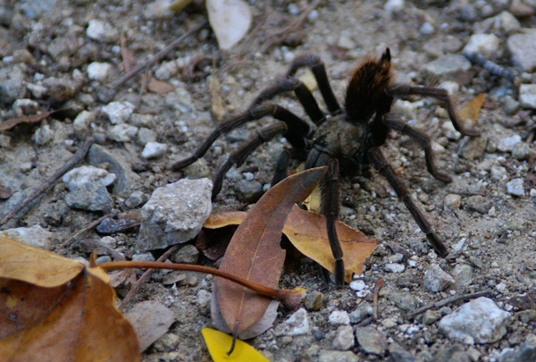 It's really too bad that the cachers around where I am aren't more of a hiking bunch. I think they're missing out on some very nice hikes and caches all in the same boat, but that's another story altogether.
The reason why I bring this up is while on that hike, CraigsOutside and I encountered a tarantula on the trail. That's not necessarily surprising since the area is know to have tarantulas, but what is surprising is before that hike, I've seen a tarantula in the wild only one other time and it was about 2 weeks before that when I spotted two others.
One was on the trail and was actually discovered by a couple of bicyclists coming down the hill. One stopped about 50 feet up the trail from me and pointed it out to his riding partners who were behind him. By the time I got up there, it was just ambling across the fire road. Later on that same hike, I nearly stepped on one at ground zero of the first stage of my multi-cache. If that doesn't get your adrenaline up, nothing will I guess. Either that, or you're just a calmer person than I.
I've encountered my fair share of creepy crawly things while out geocaching. I've spotted snakes from time to time. Once, while out hiking we came across a very large rattlesnake. Unfortunately, it wasn't really pleased with us being there, but there wasn't a whole lot we could do about it at the time, since we had it surrounded on a couple of sides. We did the best thing we could do and that was to back up and make wide circles around it. This snake encounter was in May, when the environment is becoming more habitable for all creatures in this area, but particularly reptiles, since they rely on the air temperature for warmth.
My friend CraigsOutside was bitten last year by a rattlesnake (read about it here). 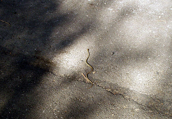 This happened in November, which seems a little strange since you would think most snakes by this time in the year would have gone underground and started hibernation. Southern California is a little bit more temperate and so in this area, we need to practice caution at all times. One can never tell, obviously, when a snake could be lurking nearby.
Before last year, I wouldn't have had rattlesnakes on my mind at all in November or December or any of the cold months of the year. Craig's encounter had me a lot more cautious yesterday while I was looking through a pile of rocks on the side of the road. I keep thinking that I really should get a hiking stick of some kind to carry along with me. Many of my friends take one along when we go on hikes. I've never found the need to carry one, mainly because it's one more thing in your hands while you're walking. Maybe I need to rethink that.
I'll be hiking out in the desert over the next couple of months. It's the most pleasant time to be hiking out there. It's cool and comfortable, much more pleasant than during the middle of the summer time. There's another figure out in the desert that we're going to create. I've written about the Smiley series and the Groundspeak logo in the past. Now, in the same general area to the west of the Smiley Series is a large PacMan. There are 30 caches, plus one mystery which makes up the eye of the PacMan. I have this feeling after we go out and find all of those, we might be singing "PacMan Fever" for awhile.
It appears as if each cache is about two tenths of a mile from the next cache, meaning this will be a 6 mile hike. That will make for a good hike if we do it all in one day. If we spread it out over two days, it'll be two good hikes. Anything over a mile is a good hike, in my opinion. And since one of our proposed hiking dates happens to fall on one of my open cache dates, that's always a bonus.
Pictures were taken at or near the following geocaches:
Give or Take 20ft - by madmaxxawr
Curiouser and Curiouser - by Terra Girl, Bean Dog, and my faithful sherpa Max

Friday, November 26, 2010
Beta Testing
Sometimes, when I hide a cache, I like to have the cache tested out by someone else. A beta tester to a geocache serves a couple of important functions for the cache hider. The primary job of the beta tester is to check the coordinates of the cacher. 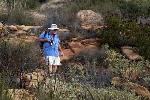 Sometimes, when the coordinates have been gathered, they aren't necessarily the most accurate.
As I posted in my last post, the accuracy of hand held GPS receivers are only good to about 30 feet. When I got to the degree confluence, my receiver said I was at the point +/- 7 feet. That was pretty good, but thirty feet could be a different story, especially if you're looking for a smaller type of container, which is where the beta tester comes into play.
I've been a beta tester on a couple of caches. I enjoy being a beta tester for a number of reasons. Sometimes, it's interesting to watch a person as they go through their hide process. Other times, it's interesting to see how close our two GPSrs are with regard to signal. Sometimes they're way off and the hider will have to do some checking to see whether it's his unit or mine that appears to be off. It can go either way.
The last time I was a beta tester, I chose to stand several hundred feet away and take pictures of the scenery. I also took a picture after my friend Chaosmanor had hidden his cache and watched as he tried to verify his coordinates. There was no way I could have seen where it was hidden and I actually had a tough time finding his cache, although I shouldn't have since it was fairly exposed from a certain angle. I didn't approach the cache from that particular angle and had a more difficult time finding it.
On another of his cache hides, he called out his coordinates to me and I inputted them into my receiver and then went on the hunt. My receiver sent me over there, which disagreed with his receiver. 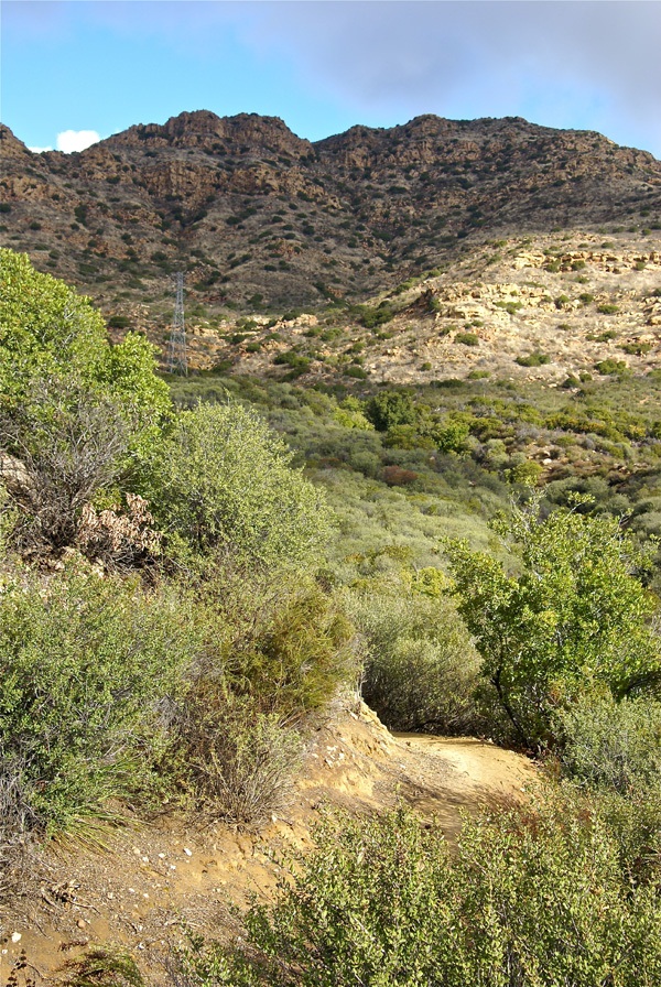 But in this case, his receiver was also pointing to where mine had been pointing and so he had to take additional readings to make sure his coordinates were accurate. In this case, it helped having that second GPSr along to verify the coordinates.
The second reason I like to have another cacher beta test my hides is I get to see the reaction of someone finding the cache. On my last hide, CraigsOutside came along on the hike. I had already hidden the cache, but was having some proximity issues with another one of my own caches. This particular multi-cache had to have its second waypoint moved in order to be published. The look on CraigsOutside's face when he found both ends of the cache was priceless. As a cache owner, you only get to rely on the log write-ups of others to see how good the cache is most of the time. When you get to see others attempt your own cache, it furthers the fun.
In reality, I think that every cache hide should have a beta tester. I think many people hide caches too quickly and don't get accurate readings for their cache hides. This leads to frustrations for cache hunters when the coordinates don't end up being very accurate. Even with an accuracy rating of +/- 30 feet, there are things that a cache owner can do to make sure that accuracy is better than that.
Having patience when taking the initial coordinates is probably the first thing that a cache owner can do to insure accurate readings. Taking more than one reading, or averaging the initial reading is always helpful, especially if there is overhead site disturbances, such as trees that could block the signals from the satellites above. Having a beta tester along for the ride will also help, in my opinion.
Pictures were taken at or near the following geocaches:
Sandstone Game Paths - by Chaosmanor
Pathfinder 59s - by Chaosmanor

Wednesday, November 24, 2010
Degree Confluence
I've always been fascinated with maps. I usually got to ride "shotgun" when we went on family trips. I was the navigator, which meant I got to follow our progress on the road atlas.  It also meant I could suggest routes of travel. Not all were taken, but it was fun to think about that road less traveled. In my travels, I've always enjoyed taking those kinds of roads, as they usually present a different perspective to what I've seen over and over again on other trips.
Such was the case over Veteran's Day weekend. Chaosmanor and I planned a trip up to Stockton. The two main routes north are either Interstate 5 or State Hwy 99. My usual route is to take the 99, because I find it slightly more scenic than the 5. More importantly, there seems to be natural breaks along the route, which helps gauge where you are on the trip. There are many towns along the 99 and I know I can usually make it to Bakersfield in around 2 hours, to Fresno in another 2 hours and then to Stockton in approximately another 2 hours.
The 5 is bereft of many cities and town and the scenery is pretty much the same with the exception of the cattle stockyards near Coalinga. Other than that, there's no way to really tell where you are or how long you have to go until you've reached your destination. If you're in a hurry, the 5 is the way to go because it's about a half an hour shorter than the 99. But the main purpose of this trip was to take the scenic route - well scenic in regard to geocaching.
Outside of the geocaches in the major cities along the 99, I've pretty much cleared out most caches along that route. So Chaosmanor suggested we take the less traveled road, parallel to the 99. It would still take us north, but we would avoid most of the larger cities, while driving through open country, which is where you can usually find large numbers of caches without the worry of caches being muggled, or having to worry about crowded situations.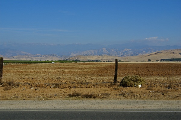
As we made our way north, I saw one of the caches that Chaosmanor had added to his route. Many caches like this I've found in the past usually are mystery caches, not actually near the geographic coordinates that are posted on the cache page. This one, however, was a regular with coordinates N 36˚ W 119˚. This would be a degree confluence, one of many points on the earth where a line of latitude and longitude intersect.
According to the Degree Confluence Project, you are within 49 miles of a degree confluence anywhere you happen to be. Just because you're close, doesn't mean that you can necessarily access these points, however. If you think about it, you'll realize that 70% of the degree confluences fall in water and are difficult to access. Many more fall on rough terrain. Although a map is flat, the world isn't and we have to take into account the lay of the land. But there are some, like the one we visited, that are very easy to access.
The confluence point was literally by the side of a road. To the west, was a large orange grove. To the south and north, the road traveled onward. To the east, the view was of foothills and in the distance, the Great Western Divide which makes up that portion of the Sierra Nevada. There was a slight dusting of snow on top of the mountains. I'm sure there's a lot more snow up there now as we've had several winter storms come through California in the past week.
 For a map nut like myself, this was kind of cool to visit. You see all of those lines on a map, yet often don't really think that much about why they're there. These imaginary lines are the basis of GPS technology. They tell us where we are and because of mathematical formulas, GPS receivers can take electronic signals from satellites in outer space and also tell us where we are, with a great degree of accuracy. Most receivers are usually good to within 30 feet of accuracy. And that's where the fun comes in with geocaching. The receivers get you close, but then you have to do the rest.
According to my GPS receiver, I was within 7 feet of the confluence, based upon the accuracy of my unit at the time I took that picture. You can also see that each of our receivers didn't agree, as I later took a picture of Chaosmanor attempting to zero his receiver out. He was standing about 15 feet away from me while I was at my ground zero point.
After I found the cache, which was hidden nearby, I discovered that my receiver had decided to creep a little bit to the west, closer to my friend's point of confluence. This isn't uncommon. When we go out caching, our units very rarely agree on a particular point, but usually get us close. For $200, I'll not quibble about slight inaccurate readings I received that day. The point is, I was the closest I've ever been to a degree confluence with fairly accurate readings. And from a geek standpoint, it really is kind of cool to see all those zeroes show up on your GPS screen.
Pictures were taken at or near the following geocache:
Confluence N36 00.000 and W119 00.000 - by TheeSugaBear

Friday, November 5, 2010
On a clear day...
In November, Los Angeles gets treated to the annual U.C.L.A./U.S.C. football game. An old saying I've heard in the past was, "On a clear day, U.C.L.A. . . . . . . . . on any other day, U.S.C. Obviously, this one was created by a Trojan fan, but if this past week is any indication, U.S.C. might be in trouble this year. 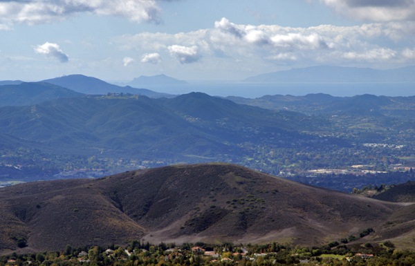 But this entry is not about college football.
Last Saturday, I went on a hike with my friend Chaosmanor in the Agoura Hills area of the Los Angeles Basin. We'd planned a trip to get us several geocaches, plus a virtual flag that would score me the maximum number of points in the game. We found several caches before heading up to the trailhead to begin our hike.
The first part of the hike was on a new trail open for about a year or so. Surprisingly, it had no caches on the trail, so Chaosmanor took it upon himself to hide a couple while on our way. Soon after those hides, we were on a fire road heading up to some caches that hadn't been found in exactly a year. Well, they still haven't been found. One cache we started to attempt, but didn't finish, mainly because the terrain had changed slightly in the past year. There was a lot of plant growth, which concealed the main way up to the cache and any other route that we could see, looked extremely treacherous and so we passed on it.
The second cache was similar, so we didn't even make an attempt to get up to it. The third cache was attempted after a nice lunch at the end of the fire road on which we'd hiked. This one was probably the most frustrating of the three since we were able to hike up to the cache site and do a very thorough search of the area. After calling a lifeline, we were pretty much able to verify where the cache probably had been, but we couldn't find the ammo can that had been placed there. 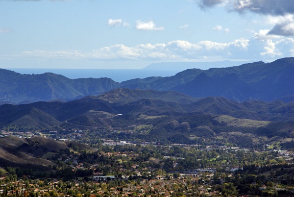 We did find, what appeared to be two Asian memoriasl, complete with pictures in nearby alcoves. The only thing we could possibly think that could have happened was that whoever put those pictures up there, took the cache for some reason.
After striking out there, we headed further up along a game trail and found another more established trail that took us up to the virtual flag and a couple of other caches, including a virtual cache at the top of Simi Peak, just inside the Santa Monica Mountains National Recreation Area. This stop was probably the highlight of the day.
The peak is only 2403 above sea level. I was able to verify that with a laminated sheet at the peak. I put my GPSr down next to the sheet and eventually, it also read the same elevation above sea level. Just after I took the picture, the elevation on my GPSr changed again. I've noticed that on other occasions as well, so I'm not ready to say that my GPSr has great accuracy when it comes to elevation, just that I was able to get the two numbers to coincide.
That didn't make the highlight reel though. What made this spot truly noteworthy was the view. Even though we were at fairly low altitude, we had a complete 360˚ view which stretched for miles and miles, literally. Originally, I had been looking to the west from the peak. Chaosmanor had already pointed out the ocean from further down, but once we got on top of the peak, we spotted Anacapa Island and behind it, Santa Cruz Island, both within Channel Islands National Park. Looking at the map, it looks like we were at least 30 miles, probably more distant from those two islands.
Then we got a bigger shock, I believe, when we looked south and could see the ocean and Catalina Island in the distance. 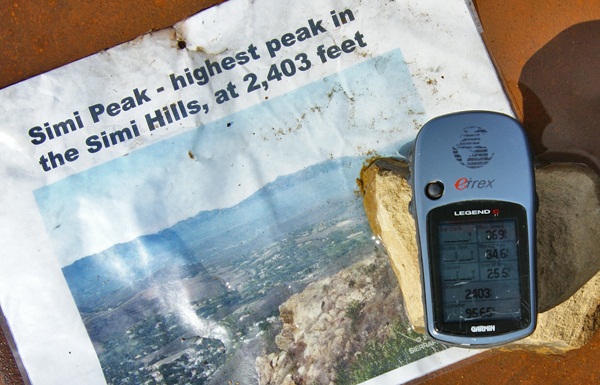 Catalina Island 26 miles from the mainland, while Anacapa and Santa Cruz are closer to the mainland. It's become a rather rare occurrence when one can see Catalina Island. It's usually obscured by haze, smog and fog, usually a combination of all three. It definitely was a treat to see it so clearly in the distance that day.
The weather conditions were just right that day where we were. Other hikers might not be so fortunate, but hopefully, that won't stop them from coming up there. I can imagine that peak in fog. That would give an entirely different perspective to the area, that's for sure. We spent a great deal of time up there, getting the necessary information to fulfill the requirements, take pictures of the scenery, take pictures of the benchmark that's also at the top and also just to enjoy the view. It's not often that the Los Angeles area is that clear. Besides the ocean views, we also had amazing views of Simi Valley to the north and the San Fernando Valley to the east. It was a picture perfect day.
Eventually, we knew we'd have to descend back into civilization and we did it reluctantly. We hiked down the trail heading to other geocaches further down the slopes of Simi Peak. At one point we missed a trail junction and ended up further north than we had originally anticipated being, so that added another mile or so to our overall hike, but it was definitely worth the effort. It had been a good climb up and a good hike totally just over 8 miles. It had been a good day.
Pictures were taken at or near the following geocache:
Simi Peak Returns - by WM6P

Wednesday, October 27, 2010
Proximity issues
Last weekend, I hid a multi-cache in an area where I hide many of my caches. I didn't figure I'd have too much problems getting this one approved since I seem to be the only one who hides caches up in that area for the most part.  I was kind of surprised when I got an reviewer notice stating that my cache was on hold until I cleared up some proximity issues.
Apparently, the second waypoint of my multi-cache was impinging upon a secret waypoint for a puzzle cache in the area. The reviewer couldn't give me any more information than that, other than to give me the cache waypoint for the puzzle cache. I was a little confused, since I wasn't aware of any new puzzle caches in the area, but when I looked at the waypoint number for the cache, I realized that it was my own puzzle cache, Cobol Canyon Trail.
I had neglected to take into account my own waypoint when laying out another cache. I found a really nifty site that will take geographic coordinates and calculate the distance between the two points. My two points are 447 feet away, about 80 less than what is expected as the minimum distance for cache waypoints set in the guidelines at geocaching.com.
After some back and forth between the reviewer and me, I decided that I had a couple of options. I could archive my puzzle cache and then there wouldn't be a problem with the multi-cache. This would be the easiest option. In fact, I could probably take the ammo can from the puzzle, move it 80 feet further away and I'd have two new caches. I've decided against this one, mainly because I like that particular puzzle cache. It gets good comments every time it's found. As most cache hiders will probably attest, a good log on your cache page is worth its weight in photons.
Pictures were taken at or near Cobol Canyon Trail - by Webfoot

Wednesday, October 20, 2010
Road Trip
My friend Chaosmanor and I are planning a road trip for next month. Veteran's Day is conveniently near the end of the week, creating a nice long weekend. 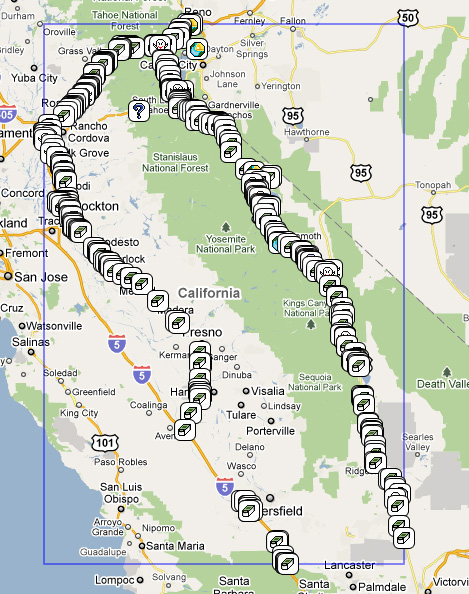 Our plan is to head up the 395 on the eastern side of the Sierra Nevada, then head over to Lake Tahoe and up to Interstate 80, before heading back down through the central valley of California.
Part of the reason for this roadtrip is to get those last couple of counties that I still need to fill up my state map. I'm pretty sure we won't get all of them, but I think the two hardest, El Dorado County and Nevada County which are at the north and south end of Lake Tahoe can be had, especially if the weather holds out for us. I'd also like to clear out a couple more of the DeLorme map pages.
For those of you unacquainted with the DeLorme map series, there are several challenges where you have to find a cache on each page of a DeLorme map. There are actually three in California, one for the northern half of the state, one for the southern half and another for the entire state. This past summer, when the Tadpole and I traveled up the 395, we got several of the pages off of the list, but I wasn't paying close enough attention at that time and missed a couple. I know I can't get them all on this trip, but any serious dent will help.
There is also a challenge cache near Hanford that I'd like to get.  10 year event cache, Chaosmanor and I actually found five different kinds of caches that day, an event cache, a regular, a multi-cache, and earthcache and a mystery cache. We've since had another day where we found six different kinds of caches. That challenge cache is high on the list of "must finds" for this trip.
And to top it all off, near that challenge cache, there are two Wherigo caches. Having never found a Wherigo cache before, these look intriguing. I'm not really sure how to explain what they are, mainly because I really don't know what they are or how they work. Chaosmanor has found one, just after he got his new GPSr a couple of months ago, so he's more of an expert. Geocaching.com explains a Wherigo cache as the following:
>Wherigo is a toolset for creating and playing GPS-enabled adventures in the real world. By integrating a Wherigo experience, called a cartridge, with finding a cache, the geocaching hunt can be an even richer experience. Among other uses, Wherigo allows geocachers to interact with physical and virtual elements such as objects or characters while still finding a physical geocache container. A Wherigo-enabled GPS device is required to play a cartridge.My particular GPSr is not a Wherigo enabled GPS, so I'll be relying on his GPS. I'll obviously be writing more about this when we get back from our trip. I'll expand on each of these in other posts over the next week or so. Until then, Happy Trails.

Tuesday, October 12, 2010
Scouting and Geocaching
I was once in the Boy Scouts. We were Troop 7 affiliated with my local parish church in Santa Ana, CA. I joined the Panther patrol, which evolved into the Hawk patrol the following year. For awhile, we had a very active troop, mostly due to the active participation of several parents, including my dad, who eventually became assistant troopmaster. The boys in the troop had a good time learning outdoor activities, and everything else that was part of scouting.
Our troop had a tradition of camping out at least once a month, rain or shine. Traditionally, we'd camp out near the beach in San Clemente in June. I can remember one year, President Nixon (yeah, I know that dates me) was going to be down at "La Casa Pacifica," the Western White House, the same weekend our troop was going to be camping at San Clemente State Beach. I wrote to the White House and invited him to a cookout with our troop. I got a nice response back from Hugh Sloan, one of his assistants. In essence, it said Thanks, but the President would be too busy to attend. I figured it would end like that and wasn't bothered by it in the least. If I hadn't sent an invitation, it definitely would have been a no.
While in the Boy Scouts, I rose to the rank of 1st Class. I enjoyed the camping, the regular scouting meetings every Tuesday night. But, for whatever reason, I had no motivation or desire to attempt to move on to the ranks of Star, Life or Eagle. The process of doing the requirements of the various merit badges held no interest for me. I haven no idea why, because I've looked at my old Scouting book and have wondered why I didn't attempt some of the different badges. Many looked interesting and fun to do. Perhaps I was overwhelmed by the requirements and the number of badges needed for each rank. Perhaps this is probably why only 2% of all scouts ever attain the rank of Eagle.
I bring this up mainly because the Boy Scouts have recently released the requirements for a Geocaching Merit Badge, which is pictured here. Some of the highlights for the merit badge, as noted in their official blog are listed here and include:
Precautions necessary to have a safe time while searching for geocaches
Geocaching etiquette and how the principles of Leave No Trace apply
Geocaching terms
How GPS Technology works
Steps for finding and logging a cache
How to use geocaching.com, the official online home of geocachingI must say, that it looks like it would be a fun merit badge to attempt.
I like the fact that Scouting has stayed true to its roots regarding most of their merit badges and that they still emphasize a well rounded young man. 21 merit badges are required to attain the rank of Eagle Scout and of these, there are 12 required badges.
Camping
Cycling or Hiking or Swimming
Citizenship in the Community
Citizenship in the Nation
Citizenship in the World
Communications
Emergency Preparedness or Lifesaving
Environmental Science
Family Life
First Aid
Personal Fitness
Personal Management
When I first looked over the list, I was surprised to not see some kind of required orienteering badge. I can remember being able to use a compass as one of the skills we learned early in our scouting career. Perhaps it's my faulty mind, or the changing of the times. With GPS technology, the need to use a compass might not seem like a necessary skill that it once was and so the requirements have changed. Either way, it is definitely still a challenge to become an Eagle Scout.
Picture of the merit badge comes from the Cracker Barrel, the Official Blog of Scouting magazine.

Sunday, October 10, 2010
Do you see what I see?
Picture day.  I wonder where that cache is hidden? The beauty of geocaching is seeing some of the great and creative ways people hide caches. I found a cache once that was hidden on a sign and had become part of the sign because of the camouflage the cache hider had done on her cache. This one was similar, however it really did have a cache. Muggles wouldn't give this one a second glance, however, it really was fairly easy for a geocacher.
Pictures were taken near the following geocache:
San Bernardino County Geocache - by TrekNTerry

Thursday, October 7, 2010
Life getting in the way
It's really interesting how life can sometimes get in the way of your goals. That's all right, because a lot of time, it's really life giving you a wake up call, usually in the form of a large two by four in the middle of your forehead. For most of the summer, I've had this goal of filling the calendar and it worked well until mid September, when I missed a day. There was no way around filling this day, because life got in the way.
Since that mid September day, I've missed four other days which will have to be filled next year if I want to finish that goal. Eventually, I'll finish it, perhaps next year, perhaps not however. And that's OK, because it's just a game. Real life is what's important. In this particular case, that two by four was a good two by four. It got me to appreciate what I have more than ever before.

Thursday, September 30, 2010
James Dean passed this way?
Fifty five years ago today, James Dean died. I was reminded of that by an editorial on the Op-Ed page of the Los Angeles Times today. I actually already knew about it, but the editorial nudged me a little.  He would have been 79 had he not been involved in that car crash along Hwy 46 east of Paso Robles.
Two weeks ago, I passed near the spot where he died coming home from Santa Cruz after dropping my son off for another year at college. Hwy 46 is littered with all sorts of James Dean memorabilia. The interchange where the crash occurred is called the James Dean Memorial junction. There's a James Dean memorial and virtual cache just east of there. The highway is called the James Dean Memorial Highway.
We in America have an interesting fixation about stars who die before their time. Marylyn Monroe, Elvis, Michael Jackson and James Dean all seem to fit this bill. It's hard to know where James Dean fits into this mix. He made three films, died before two of them were released. Most people, I think will remember his role in Rebel Without a Cause, staring two other young actors, both of whom died premature deaths, Natalie Wood and Sal Mineo. If you've never seen this film, it's a good one to watch, especially if you want to learn about teenage angst of the 1950s.
Giant gives you a glimpse of Dean and how he might have looked had he survived. Giant is a big set piece set in Texas during the oil rush. Rock Hudson and Elizabeth Taylor fill out the cast of stars. Dennis Hopper also makes an appearance. However, I think Dean's best work, is in the film East of Eden. I can remember seeing this one in college, after having seen the other two several times while in high school. East of Eden hardly ever gets shown, but it's a very fine film both from an acting standpoint by Dean and others and the cinematography. 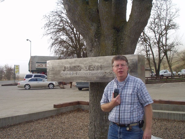 Rent it and I don't think you'll be disappointed.
I bring all of this up mainly because as I was driving on Hwy 46, I ended up geocaching along the road. One cache took me off the main highway to an old bridge which paralleled the highway. Little used, the bridge is in a state of decay and will eventually be replaced. It's interesting to think about, but it's a bridge that James Dean probably traveled over on his ill fated last trip. Over the years, the highway has been realigned several times to make it wider and straighter and thus, safer for motorists. Much of the old road is probably gone entirely and the exact spot where the car crash took place isn't on the highway anymore.
I'm actually surprised that some preservation society hasn't come along and decided that this little piece of history deserves to be preserved. It's probable that this might happen in the future, when the wrecking ball comes into play, but it's also just as likely that this old bridge will slowly drift into obscurity. Or then again, maybe this is just an old side road with no link to what happened so long ago.
Pictures were taken at the following geocaches:
This Old Bridge - by Scooterman
James Dean - by TahoeTeach

Monday, September 27, 2010
Meets and Greets
Back in April, I wrote about a mini high school reunion that I attended. At the time, I thought I might have recruited a couple of new geocachers.  I'm not sure whether that panned out or not, but it sort of whet my appetite to try and go to a couple of geocaching events, something that I have not done a lot of in the past.
I attended an event celebrating the 10th anniversary of geocaching back on May 1st. That was a very enjoyable afternoon. We ate, we talked geocaching, then many of us went on a hike through the Devils Punchbowl, picking up some caches we hadn't found on previous outings to the area. All in all, it was a very good day.
This past Saturday, I attended another event hosted by BigDaddyGRC and ScrabbleDogs. BigDaddyGRC is one of the hiders of the Groundspeak series that I've written about, plus the Smiley Series. I'd met him at the 10th anniversary event and had enjoyed his company then, so when my friend Chaosmanor pointed this event out to me, I thought it might look interesting.
Unfortunately, the Tadpole also had a cross country meet that day, so I couldn't be in two places at the same time and family comes first. However, he hadn't been feeling well with allergies all week, due mainly to the local county fair and didn't end up running on Saturday because of it. That freed up my day once I got the lawn mowed.
I was able to get the lawn mowed early in the morning before it started to heat up and then took off. I found a couple of caches on the way up the hill to the event, which was held at the Grassy Hollow area near Wrightwood, CA. 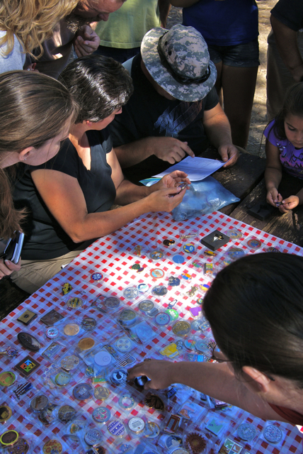 This area has a very nice visitors center and has a nice group campground designed for through hikers on the Pacific Crest Trail. I had been up here one other time back in November 2002 looking for a cache hidden right along the PCT.
The event was a potluck hamburger/hotdog barbeque and the day couldn't have been more perfect. The people who came up were similar to me in that we were all beating the heat. The temperature at my house on Saturday was 99˚, while up in the mountains, it was probably in the low 80s - quite pleasant for a picnic and subsequent hike along the PCT. BigDaddyGRC was a fine host, cooking the burgers to perfection and we had plenty of food for everyone. In fact, if people went away hungry after this event, it was their own fault.
At any of these events, most of the cachers tend to know one another, either because they've met in the past, or they're familiar with them due to seeing their names in logs somewhere while out caching. This event was no exception, but it's still nice to finally put cache names to faces. I met three of the 4DirtyDogs that afternoon, as well as RedBaroness, Shell1Fish, NascarFamily.
We ended up talking for several hours about different things, including geocoins, old time caching back in the early days when you'd go for a hike of 2 miles and find one cache. That was the case when I'd gone after that cache up here. It was the only one there. Now there's about 10 caches available to find within a two mile radius of the picnic area. We were also treated to a nice geocoin collection by Steben6.
After the raffle of some prizes, which I think ended with everyone in attendance getting something related to geocaching, geocoins, we all headed our separate ways. I ended up hiking with Chaosmanor and the 4DirtyDogs over to a cache. Our group eventually ended up being 10 cachers strong and it was fun talking about stuff while hiking along the trail. We eventually ended up over at the Grassy Hollow Cache which I'd found 8 years ago. It was fun watching others find this old cache.
I related about how few and far between caches were back then and talked about the differences in caching between then and now. Logging in the logbook was an art and people tended to write stories. While the others signed the new log book, I was busily looking through the old logbook of this cache. As I was looking, it dawned on me and I also voiced it out loud, that I was going to be pretty embarrassed if we encountered my name in the log book and there wasn't a story attached. 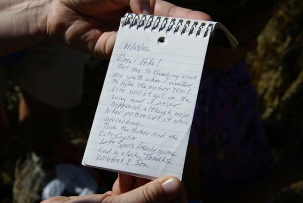 I breathed a sigh of relief when I found my entry and noticed that I had indeed written a short story about the experience.
The last cache the group ended up finding was a picture puzzle cache, one where cachers had to walk along a trail checking out the viewpoints until the view matched up with a set of pictures attached to the cache page. Once the pictures lined up, supposedly you would be at the cache site. A lot of debating went along with this one as we walked along, especially after we saw the lake down below which showed up in one of the pictures. Eventually, we were able to get the "right" view and found the cache, a fitting end of the day cache find.
I looked on my profile page while writing this one and this was only the 10th event I've chosen to attend. I'm averaging about 1 per year, but I know there have been several years where I haven't attended any events, while other years have a couple. I'm already planning on attending another local event on the 10th of October. I can't resist the numerology of 10/10/10. I'm pretty sure I'll enjoy that one as much as I enjoyed this last event last Saturday.
Pictures were taken at or near the following geocaches:
A Day in the Angeles Forest - Grassy Hollow - by HDGC (BigD'GRC and Scrab'Dogs)
Grassy Hollow - by John, Donna and Slipper

Monday, September 20, 2010
Wait'll next year...
As my son the Tadpole told me yesterday, I guess I'm going to have to wait until next year to fill the calendar out. Saturday was an incredibly busy day. I was on a road trip north to Stockton to help my daughter move into her new place and there wasn't any time during the day to go out and find a cache. So, for the next year, I'm going to have at least that one empty spot in the middle of September staring at me. Wait'll next year? I don't really have a choice on this one.