Saturday, I went up to the mountains to pick up my daughter. Obviously, since this is more about the desert than the mountains, I took a pretty circuitous route to get to the mountains. In fact, it was a rather longish route, but very fun.
I've been watching a couple of the virtual flags out in the desert and noting that several of them were about to expire, so I decided that Saturday morning would make a good trip out to get them. I created a bookmark list of caches along my intended route as well, so 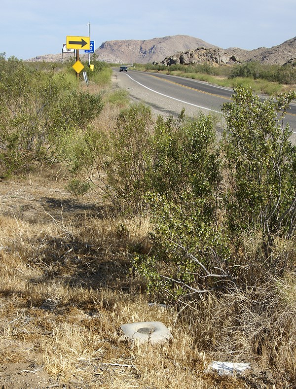 I could do some geocaching in between picking up the virtual flags.
My route took my up the Interstate 15 into Victorville, then east toward Apple Valley. There I was able to score a Bhutan flag. I also found a small cache behind a movie theater. Then I proceeded east along a road the Tadpole and I had traveled in the past. My goal was to head to the northern border of Joshua Tree National Park, mainly because there was a cluster of 3 virtual flags out there, plus one nearby.
As I was traveling, I kept noticing some of the caches that had been part of my PQ show up on the screen. There didn't seem to be adequate stopping areas for many of the caches, or either I was driving too quickly to make good stops, but I was able to make one stop at a cache entitled, POINT. Team Christiansen has created a bookmark of caches in the Apple Valley that are placed near benchmarks. With 32 caches on the list, someone who is interested in benchmarks would be able to spend a rather enjoyable day out there finding caches and logging benchmarks.
After parking near POINT, I got out of my car and immediately spied the nearby benchmark. No, not just one did I spy, but three benchmarks. This was almost as good as the other cache where the Tadpole and I found five benchmarks in one spot. After finding the cache, I went over to document the benchmarks. There were three benchmarks aligned in a row just off the highway. After taking the requisite pictures of each, plus a picture of each so people could get perspective on how they looked in the environment, I checked the cache page and realized that I'd missed one. A quick survey and I was able to spot the 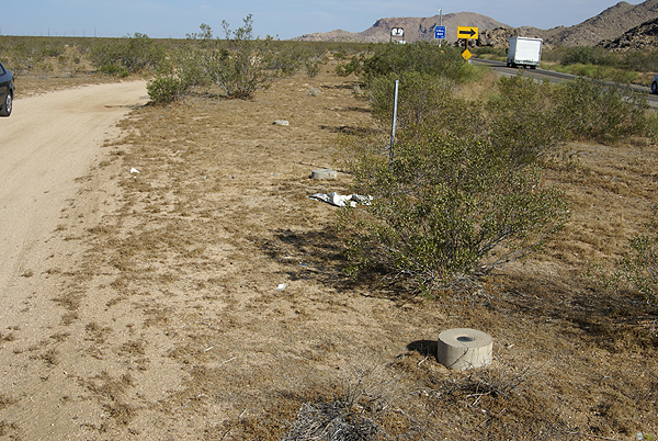 other one, located in a line perpendicular to the center mark.
I was able to log three of the four marks. One of the marks in the line of three was a newer benchmark from 1983 and wasn't in the benchmark system at geocaching.com. The other three, arrayed in a triangle shape all dated to 1934, the year after my parents were born. I'm at a loss at this time as to why the National Geodetic Survey wouldn't have that last mark in the database yet. Yet, I encountered another benchmark once I got over to the other virtual flags that wasn't in the system either.
This benchmark, which I found 38 feet away from a hidden cache, was a pipe cap type of benchmark, driven into the ground right on the boundary of Joshua Tree National Park. The mark is dated from 1932, so it's relatively old and I was hoping that it might be in the system, yet when I checked later on, it was not to be found. 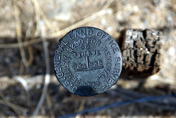 Even more curious, was other benchmarks, exactly like this one, were in the system. It's kind of interesting how hit and miss they seemingly are at times.
I think I'll keep these photos in a safe place. Who knows? Perhaps in the future, I'll be able to pull them out of the archives and log them when the database gets updated. From past experience, I was pretty sure I'd logged all the ones in my local area, but now it appears as if new ones are showing up in the database. This would indicate that the database does get updated from time to time. Now I just need a way to remember that I have them.
Pictures were taken at or near the following geocaches:
POINT - by Team Christiansen
Architectural Digest - by Joshua Tree Bonnie & Clyde
Sunday, May 31, 2009
Desert disks

Thursday, May 28, 2009
More metal disks
Besides the water tank and geocaches, we also found several benchmarks this past weekend. I've written about benchmarks many times in the past, but for new readers, benchmarks are things placed in the landscape that are 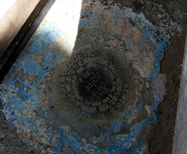 usually fairly permanent, which allow surveyors to do their work. Of the benchmarks we found this weekend, three were relatively easy to do since they were near geocaches we were searching for at the time. In fact, we actually did better finding the benchmarks than we did finding the geocaches, finding one cache while finding three benchmarks. In all fairness, one cache was near two benchmarks, but we posted a DNF on the other cache.
My friend Chaosmanor enjoys hunting benchmarks. He also enjoys submitted reports to help update the benchmark database. As of this post, he has logged 192 benchmarks. He doesn't submit reports for all of them, but I'm sure he's submitted a great many of those 192 benchmarks. My paltry 27 benchmarks pales in comparison. I would like to add when I found we were near some benchmarks, I made it a point to let everyone know that I was interested in finding them, not just get them if we got close. We actually made these 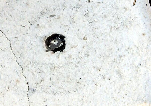 benchmarks part of our focus of the day, not a sidelight.
Of the four benchmarks I logged on Saturday, I would say only one was the classic type from the US Coast and Geodetic Survey (USGS). There have been other types of benchmarks added to the database in recent years, so there are now more opportunities to find and log benchmarks. The other benchmarks found on Saturday came in two different types. One was just a nail with a small disk attached to it on the base of a bridge. If you were to go out in your front yard, you might find a similar looking thing along the curb in front of your house. Where I used to live, I had two of them, one on each side of my property. The nails/smallish disks marked the edge of my property line from my neighbor's.
The other type of disks I encountered on Saturday was similar to the classic USGS disk, only they were smaller. One was 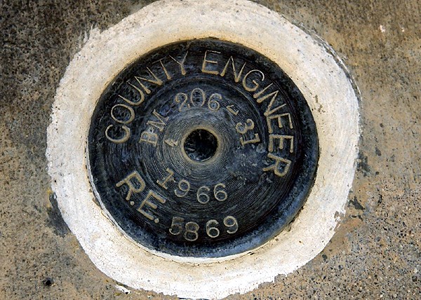 found in the base of a flag pole outside of a fire station. This particular benchmark was a county engineer benchmark, placed in 1966. According to Chaosmanor's log from 2004, the firemen who worked at the station were unaware of the benchmark or it's significance. As I posted in the first post linked above, many people are unaware of benchmarks, even when they pass them on a daily basis. They are basically overlooked.
The other disk was attached to an old bridge, much like the classic USGS disk we found earlier in the day. Many old bridges tend to have these benchmarks, mainly because the bridges can be viewed as fairly permanent structures. The bridge where we found the cache and benchmarks had been bypassed by the road that used to travel over it. As cars were whizzing by at 60 mph, we were checking out a cache and nearby benchmark in relative peace, with the exception of the road noise 40 feet away.
The benchmark, which was placed by the Flood Control District, had been painted over. I've actually seen this a lot. One of the first benchmarks I logged has now been painted with red paint 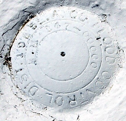 because it's on a curb and the city of Claremont, CA wants everyone to know there's no parking at this location. Couldn't they have done this without painting over the benchmark?
As I continue to explore back roads, I'll probably end up finding more benchmarks. Sometimes, I've even found myself looking at older structures and bridges wondering whether there is a benchmark placed on it. I would suspect with satellites and other technology, that benchmarks, although useful, might not be utilized as much as they were in the past. Probably? Maybe? A lot has changed in my lifetime and who knows if they'll still be used in the future. In any case, I'll continue to look for them when I can. They're sort of a link to bygone days, when everything in life tended to move a little slower.
Pictures were taken at or near the following geocaches:
Bridge, Benchmark and Booty - by Yosemite John and Debbie
Ode to my GPS - by The Long Riders and glh
Bridge, Benchmark and Booty II - by Yosemite John and Debbie

Monday, May 25, 2009
Geocaching and waymarking
This past Saturday, I was able to get out for the first time in a week to do some geocaching. The Tadpole and I met up with Chaosmanor near Hollywood to do some GeoVexilla and some geocaching up north of 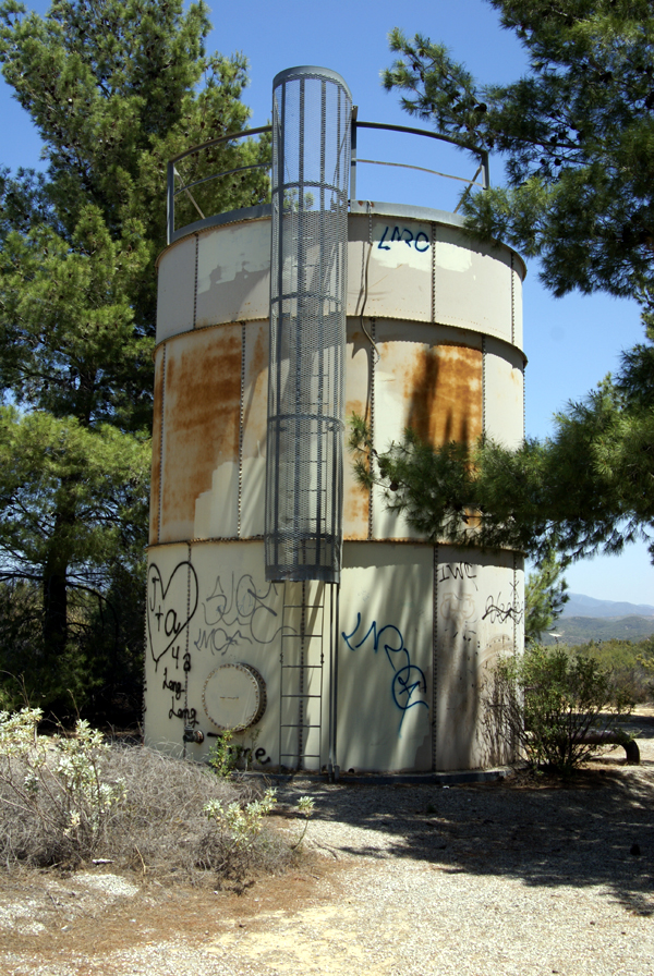 Lake Castaic. The afternoon was primarily a cache run with a strenuous hike along the lake shore to find a couple of caches.
Along the trail, on a ridge overlooking the lake, we came upon an old water tank. I'm not sure what area or town was being serviced by this tank, but it was clear that this tank had seen better days. As you can see by the picture, the tank has been struck by graffiti numerous times. Surprisingly, there wasn't a lot of trash in the area, probably because the narrow road leading up to the tank and beyond had a locked gate on it. Too often, less populated area tend to become dumping grounds for people that either can't afford the fee to take their trash to the dump, or don't want to be bothered. Places, that could be very beautiful, become blighted in the process. At least this hadn't happened here outside of the graffiti.
The tank was situated in a copse of pine trees. The trees were obviously planted to obscure the tank, making it less of a public nuisance. I decided I'd waymark this tank, since the water tower category is one of my interests at Waymarking.com. We continued our hike beyond the tank and came to the cache we'd set our sights on earlier in the day. This particular cache gave us a lot of trouble because it was well hidden. My GPSr kept telling me I was at ground zero in the middle of the trail, only about 6 feet away from the cache, yet I never did spot it. All three of us probably walked right by it several times. Eventually, Chaosmanor spotted a small portion of the lid of a decon container peeking out and we had the find. The view from 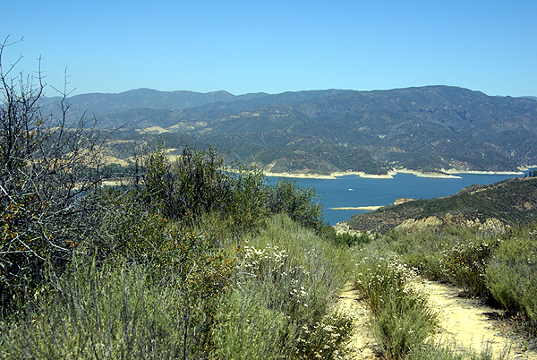 the cache site was spectacular.
After finding that cache, we headed down below our parking area to another cache. This particular cache had been hidden west of a former picnic area overlooking Lake Castaic. Unfortunately, the area had been closed for some time. The road down was in disrepair and the picnic area were overgrown with weeds. The two bathrooms had been totally trashed and it was evident that the local graffiti artists had been at work on several of the structures.
We would have actually missed most of this had we paid better attention to our geosenses and GPSrs. At one point, we had the opportunity to either stay on the road, or take an overgrown trail. It looked like the road was going to take us to the same place, so I opted for that route, since the main overgrowth on the trail was foxtails. Anyone who knows me very well knows that I detest foxtails. In reality, we encountered foxtails all day long so it really wouldn't have made much of a difference and had we taken that particular trail, we would have avoided all of the graffitied buildings, etc. that we passed on the hike.
Eventually, we ended up out on a point overlooking the lake. The GPSrs were pointing us in a variety of directions, but we didn't have much room to maneuver around because the trail became, in Tadpole's words, "Uber steep." and would have become treacherous had we continued, so I figured 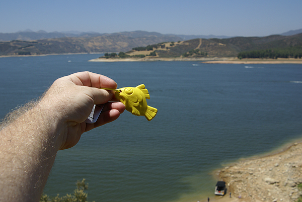 the cache had to be close. I needed the hint on this one, but eventually I was able to put a couple of pieces of the puzzle together and I went around a large bush and finally found this cache. The views, again, were great and I decided to leave a travel bug that I picked up in Stockton last weekend in this cache. I couldn't think of a better place to put a fish than in a cache right by a large lake.
The hike back up was strenuous, but we made it up without too much difficulty. In a couple of months, the trail will be very difficult because of the summer heat. There was little to no shade. Hopefully, someone else will be down there to pick up the travel bug, otherwise it might stay there awhile. All in all, it was a good day. But then again, when I go out caching with the Tadpole and/or Chaosmanor it usually ends up being a good day.
Pictures were taken at or near the following geocaches:
Lake View Cache-taic - by Team Magpie
Below the Castaic Overlook - by Don J

Tuesday, May 19, 2009
The Answer My Friend.....
This past weekend, I did a quick turnaround trip up to Stockton to pick up my daughter from college. I'm just recovering from the trip, but then again, most of us who are slightly older know what a 1000 mile round trip 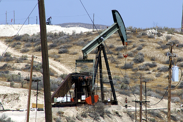 can do to the body, especially if it's done in only two days. I definitely know that I'm not as young as I used to be and can't just hop in the car and drive 12 hours or so without feeling the side effects.
Driving up, I decided to take the back roads, although they weren't necessarily the most scenic. There were several virtual flags just off the Interstate that it appeared that I could get close enough to, so I routed to those and also did some caching. Consequently the trip up took about four hours longer than usual, but it was an enjoyable extra time. Driving, then getting out and caching for a little bit tends to help keep me refreshed for the drive to come.
The side trips took me through the oil fields in the southern central valley around the town of Taft. Nothing really spectacular about this area, although I did get a little bit of a jolt at one cache. It's definitely heating up in the central valley and summer is upon us. The drive home, I noticed a time and temperature sign in Bakersfield that read 106°. Granted those  you always take with a grain of salt, but even at 10 degrees off, that's plenty hot for May.
The cache that I found near Taft hadn't been found in over a month. Apparently, the seal on this particular ammo can was a really good seal. With the heat of the sun beating down on it, the insides were very warm and I have to theorize that the air pressure inside it was slightly higher than the outside. When I popped the handle on the ammo can, the cache hissed at me giving me a little bit of a start. This was one of those moments that I was glad that I had been caching by myself, because I know I jumped, which would have probably caused some laughter from any caching buddies that would have been along for the hunt.
Later on in the day, after getting back over to the Interstate, I took my second side trip, this time into the San Jose area, which is near the southern part of San Francisco Bay. Once again, I was looking for a couple of virtual flags and a couple of caches. The one cache that stood out in this area was a kinetic sculpture. While waiting at the light to turn into a business complex, I noticed the sculpture from a couple hundred feet away.
A quick glance gave me one of those, Oh, OK. That's kind of interesting. When I looked again, I noticed the sculpture had changed. Now this was interesting. Once I got up close to it and had parked the car, I realized the sculpture was two large panels that swiveled at their midpoints. They would wave back and forth with the wind, not a lot, but enough to get a different look every time you looked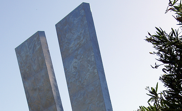 at sculpture. I took a couple of pictures, one while flat on my back so I could get it and the buildings behind it in the same shot. The metal had an interesting texture to it as well.
There wasn't any explanation, except who created it and what the name of it was, but I would have liked to know how much the panels actually fluctuated in the breeze. There was a gentle breeze blowing that day, but I wonder what the panels would do in a brisker breeze. We get gale force winds down in Southern California from time to time and I would imagine that can happen in the Bay Area as well. I guess, I'll just have to come back up here some time when the winds are really blowing to find out.
Pictures were taken at or near the following geocaches:
California's Other Gold - by feedle
Silver Gyrations - by N2Books2

Thursday, May 14, 2009
Reminiscing
When the Tadpole and I went out last Sunday, we deliberately stopped at 2501 cache finds for me. Everyone has numbers in their lives that have some significance to them. This is one of the ones that I'll remember for my entire lifetime. 2501 S.  Linda Way, the blue mark on the satellite image is the house in which I grew up in Santa Ana, CA. I lived there from age 3 (1961) until I moved out several times during and after college, and finally moved out for good in the fall of 1983 just after I got my first teaching job in Buena Park. My parents moved to Riverside, CA about 10 years ago, moving to be closer to all three of their children.
The cul-de-sac to the southwest of our house was where the neighborhood kids played baseball. You can see the manhole cover we used for home plate. Joe's house, at the entrance to the cul-de-sac on the south side was out of bounds and an automatic out if you hit the ball into his yard. He didn't like us playing and made it clear that we better not go on his lawn. Mad dashes were made whenever an errant batted ball ended up on his lawn. Fortunately, I don't remember a single lefty in the neighborhood, so we were usually pretty good about avoiding his lawn.
I've lost touch with the old neighborhood kids, although I've bumped into one of the girls who used to live on that cul-de-sac. She's now a teller at my local credit union. All of her brothers and sisters now live out in my area, about forty miles away from where we grew up. Looks like many of us didn't leave home too far behind.
I went back about 6 months ago, because I happened to be geocaching down in the area. The house looks very familiar, although it has bars on the windows now. We drove by, looked at it and drove on. I pointed out some of the landmarks of the neighborhood, some of the things that weren't there anymore. Then we went out and found the cache that was in the park closest to the house.
Although it's no longer home, I have fond memories of that house. I learned how to behave properly with other adults in that house. I learned the importance of taking care of animals in that house. I learned how to be a good citizen in that house. I grew up in that house. It will always have a special place in my heart.

Monday, May 11, 2009
Milestone
This past weekend, I passed a caching milestone. I have now found just over 2500 geocaches. At the moment it's a number, but it seemed to be pretty important to my son this past weekend, so I made sure he was part of it. Saturday we headed out, trying to get the 11 caches we needed, but were thwarted by Father time. We only had the morning, because of other things going on that weekend, and we 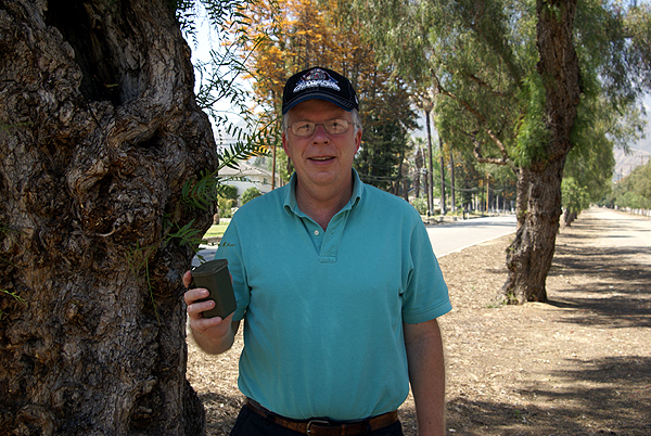 only found 7 caches. I told my son that it looked like I was going to end up getting my 2500th sometime on the road this next weekend when I went to get my daughter from college. He was visibly upset about that. It was at that moment, I made up my mind, that if I could, we'd get out caching sometime this week and get those last four elusive caches so he could celebrate the milestone with me.
At first, I thought Sunday might work, but it was also Mother's Day and as a friend wrote to me later, "Caching on Mother's Day? You are a brave man." But after talking with my wife and discovering that my other son had a project to work on at a friend's house, the peace and quiet of a Sunday afternoon for her looked mighty enjoyable, so off we went to cache.
The finds came easily yesterday and we were at 2499 quickly. For 2500, we chose a smallish cache hidden by ballerinaprincess, who lists her occupation as a kindergartner. I've met her once and she has hidden some very fun and challenging caches for a person of her stature and age. This one was no exception. It was a decon container hidden in a hollow space in a tree, waist high to a ballerina princess according to the hint.
The Tadpole took my picture at the cache site with cache in hand and he and I logged the cache. After finding one more cache, we came home very pleased with our success of the day. I'm glad I said something about possibly not finding the cache, otherwise I might not have known that he wanted to be there. I need to remember that for future reference.
Picture was taken near Ballerina Decon - by ballerinaprincess

Saturday, May 9, 2009
Getting close
With a busy Mother's Day weekend, caching has been put on the back burner for awhile. The Tadpole and I were able to get out this morning for a little caching. This morning I needed 11 caches to get to 2500 found. The goal was to spend the morning and get to that number before lunch, then come home and spend the afternoon listening to my wife perform in her jazz band at our church fiesta.
Well, we fell four caches short, but we still had an excellent morning and the music in the afternoon was also very enjoyable and relaxing. After posting this, I plan on heading back there to eat dinner with my family.
This upcoming weekend, I'll be heading toward Stockton. My daughter is finished up her finals this week and completing her second year of college at the University of the Pacific. It will be good to have her home, if only for a month before she heads to Michigan for her summer counseling job at the Interlochen Institute for the Arts.
Monday, May 4, 2009
Nice Gneiss
When I go out geocaching, I'm always looking around for interesting subjects so I can improve my photography skills. I  end up taking a lot of pictures of flowers, mainly because they tend not to run away from me when I approach. Animals usually end up next on my list, although they do tend to not like it when I get too close, so I have to resort to my telephoto lens and sometimes hope for the best. Every now and then, I end up taking pictures of rocks, either because it's required of me due to an Earthcache that I'm logging, or because something has struck my fancy about the rock.
Usually, what I find interesting others might just pass by. I'm frequently at awe over the power of nature, especially the interaction between plants and the rocks and how they interact with each other. I love looking at tree roots, especially if they on the upper side of a trail, because you can see how they sought out the cracks in the rock where there might be some soil. You can also see how the tree roots hold the hillside in place and wonder how the hillside might be different looking were those trees not there.
About a month ago I was on a hike with my friend Chaosmanor and we noticed some faulting along a rock face. There were some bands of striated rock material that had been misplaced in numerous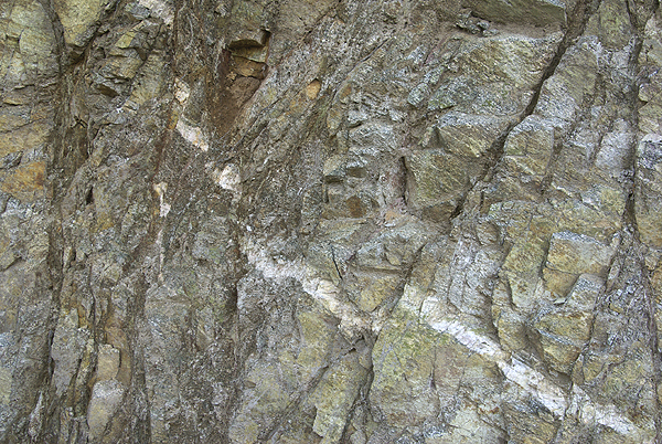 places. Chaosmanor was intrigued enough that he took several pictures, as did I, and has decided to create an earthcache along that section of the trail. We had an interesting discussion trying to decide whether the rock pieces had dropped down between the faults or had been uplifted. As an amateur geologist, I find rock faces that tell stories like this very interesting.
I also enjoy trying to identify different types of rock. Usually this happens when Chaosmanor is along with me, mainly because he has similar interests to my own in this area. When I try to talk about rock types with other friends, a lot of times you can see their eyes glaze over. "Geez, he's talking about rocks again." Chaosmanor and I, on the other hand, enjoy a good talk about geology. We even like to throw a pun at each 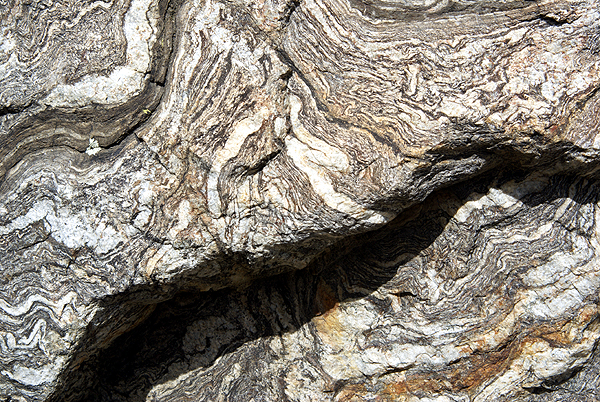 other from time to time when one of us has correctly, or even incorrectly identified a certain type of rock. "Gee, that is some nice gneiss you're holding there."
I can probably blame my father for this love of rocks. He was the one who took us to Yosemite, frequently over the course of my developing youth. I can blame him because I like to look at large rocks as opposed to tiny grains of sand along a beach. And if you don't believe me, you can always say that I'm full of schist.
Pictures were taken at or near the following geocaches:
Subterranean Homesick Blues - by Terra Girl
Micro N Post - by not tom
Tree at 4737 - by not tom

Friday, May 1, 2009
Cache maps Part II
Once you have your data in a text file, either by using my method, or by using reader Benh57's method, you'll need to upload it to a server. Most ISPs allow individual webspace and there's plenty of free spots out in the world wide web for you to do this. Once that is done, you just need to set your parameters for the kind of map you want.
I don't have know all of the parameters that can be used, so I'll interpret what's listed above for what I have on my particular map. All of the other parameters can be found here.
One of the things that I wanted to do was have a map that concentrated on the areas where most of my caching would take place, so I wanted to have the map centered in such a way that Southern California  would be near the center, but not quite since I knew I would eventually be caching further north and east. By trial and error, I centered the map at 36.6° north latitude and 114.9° west longitude, which puts the center of the map in Nevada, about two miles east of this cache. The map to the left is a smaller version of the entire map.
The next two numbers specify in decimal degrees, how tall and how wide the map will be. In this case, the map will be 14 degrees by 11 degrees. By changing this you can cover larger or smaller areas of the globe. By making the numbers smaller, you'll obviously zoom in on a given area, which is what I did to show you the smiley out in the Mojave desert that we created when we found the Smiley series of caches.
The last two numbers creates the size of the map that will show on your screen. The default is 256 by 512 pixels which was a little too small for my tastes, so I upped it to 600 by 800. Once I get a bigger monitor or a new computer, I may up those so the map will fit on my screen again. The last thing I wanted for my map was to have the county boundaries show up, so I added the "on=counties" parameter. You can add railroads, streams and major highways to your map, depending upon what you want to display on your map. The choices are totally yours.
The last piece to the map is to add the url of your text file wherever it is stored. My caching map can be viewed here. The Tadpole's map showing his cache finds can be viewed here. The one thing to remember is the entire URL for the map, including all of the parameters is limited to 256 characters. Play around with it a little bit and you'll soon have a map to your liking.
