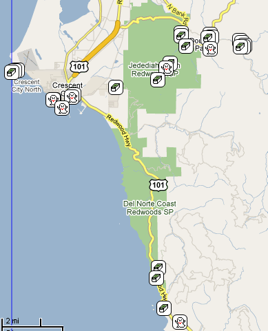
The first day of most trips is usually a lot of driving. That was the case on our first day as well, but we tried to break it up into some shorter chunks with some geocaching here and there. We ended up finding five caches on the first day, which was actually  more than I expected to find. We found three in the central valley of California as we drove up Interstate 5. We found two others later in the day, a virtual in Oakland and one near our campsite which would be our first find in Marin County.
When driving in California, you have to plan accordingly. If you're ending up traveling through either the Bay Area or the LA Basin during rush hour, you're going to be sitting in traffic for awhile. We'd left our house at 8:45 in the morning which allowed us to miss the Los Angeles traffic. The problem was as we approached the Bay Area, we were entering that during the afternoon rush hour. Fortunately, some peripheral freeways allowed us to miss most of the traffic, so it really wasn't bad, except we missed part of our caching route. Well, as noted above, we'd already found three for the first day, so it was a good start.
As we got through Oakland, I noticed a cache showing up just off the freeway near the marina in Oakland. I pulled it up and realized 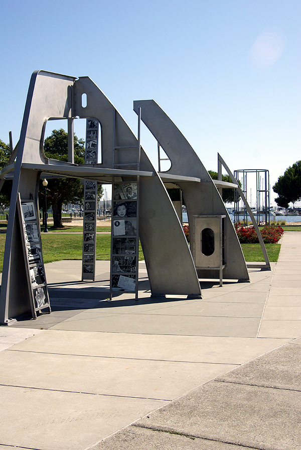 it was a virtual. The Tadpole enjoys virtuals because he finds them very educational, so we stopped and learned about Rosie the Riveter's important role during World War II at the Rosie the Riveter/World War II Homefront National Historic Park. This was a self guided park through a mock up of a ship under construction. Along the ship's lines were historical pictures telling the reader about the role women played in the war effort. We followed the partial skeleton of the ship all the way down to the water's edge. Most of the information was not new to me, but the Tadpole was fascinated with the exhibit and I think we stayed longer because of that. After getting the necessary information for the virtual cache, we got back in the van and headed toward the Richmond/San Rafael Bridge and to our campground.
After setting up camp and eating dinner, we walked through the campground. We attempted to find a couple of caches that had eluded us last year, but were defeated again. So we satisfied ourselves with one more cache attached to a gate on a Rails to Trails trail. After that, we pretty much went back to our campsite and hit the hay. It had been a long first day, yet also rewarding at the same time. We would have many more over the next two weeks.
Pictures were taken at or near the following geocache:
Bay Area History - Rosie - by Jean&Jim
Friday, July 31, 2009
First Day

85,000 Words
If a picture is worth 1,000 words, then the 85 pictures that I've posted to the geocaching website is obviously worth  85,000 words. Not that I'll write that much, but I'm just preparing you for what lies ahead.
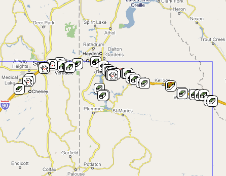
The past couple of weeks have been absolutely amazing. The Tadpole and I ended up camping for 2 days near Point Reyes National Seashore in Marin County, CA north of San Francisco and then for another 4 and a half days in Del Norte Redwoods State Park which is part of Redwoods National Park. Then, we met with a friend of mine in Oregon and finally with my dad up at his place in Idaho. I left the Tadpole with my Dad in Idaho and brought my other son, the Runner, home with me with a stop in Santa Cruz for his freshman orientation at UC Santa Cruz - home of the Banana Slugs. Over the next week or so, I will attempt to chronicle our trip in terms of caching, waymarking and other GPS games. Hopefully it will be interesting to everyone concerned. It's good to be home.
Picture was taken at or near the following geocache:
Point Reyes EarthQuake Trail - by forman

Monday, July 13, 2009
On the road again
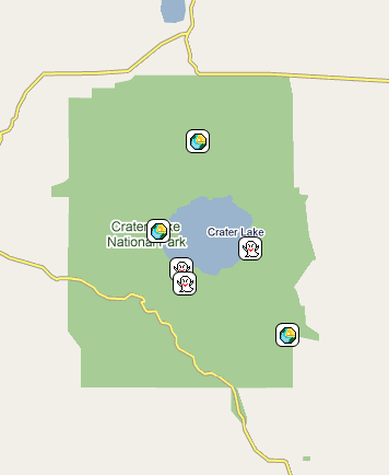
In about 10 hours or so, I shall be on the road again with the Tadpole, heading for Marin County north of San Francisco for our annual camping trip. If you recall from last year, our trip was cut short because the Tadpole became ill the first night. We're planning on doing much the same trip as before, but then heading north through Crater Lake in Oregon and finally up to Couer d'Alene, Idaho. I will probably be without Internet access for much of the trip, so don't expect much, especially in the next week. Once I start home, I'll probably be able to post, but without any pictures. Eh. It's only 1000 words here and there.
Saturday, July 11, 2009
Roll Call
Hungry Hungry Hippo? Road Warrior? Pink Dog? Roger Raccoon? chaosmanor's Idaho 2008: Goose Creek Falls - bronze? Not another micro! Geocoin?
Here!
Six travelers are coming with us when we begin our caching/camping trip next Tuesday. Unless I get out in the next couple of days to a 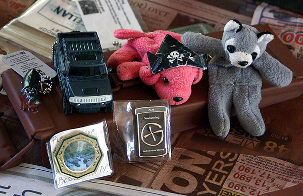 travel bug hotel, that looks to be about it. Not like that's a bad thing, it just represents a small amount of travelers that I'll be able to move along on this trip. I've moved upwards of 18 bugs and coins on other trips. That was fun, but I'm not sure I'd want to repeat it in the short time frame of 3 days that I had. With 14+ days in which to travel and cache, I have plenty of time to drop travels off at my leisure. I actually wish I had some more.
We encountered several caches while down in San Diego this week where there should have been travel bugs. I think of the 7 caches we found, 4 had listed travel bugs in them, yet all of the caches were empty. Unfortunately, this seems to be a common theme. Either people just don't understand the concept of logging the travel bug onto the geocaching site, or there are a lot more thieves out there then I'd like to believe. I'm hoping it's the former as opposed to the latter.
Most of the goals of the ones that I have are pretty modest. A couple just want to travel from cache to cache. I can do that. One wants to get to the east coast and another wants to get to Delaware. Well, I can get them a little closer, especially if I end up putting them in the eastbound rest area in Montana. That should get them closer. Chaosmanor's geocoin just wants to stay in states that surround Idaho. I'll find a cache in Idaho and leave it there. The Pygmy Hungry Hippo I really like. It wants to share your meals with you. I can think of some great photo ops for this one on our camping trip. That one should be fun to play around with before I drop it off somewhere.
If I get the chance, I'll try to get out to our local travel bug hotel to see if there's any bugs in it. I've found that I like to move travel bugs over geocoins mainly because the photo opportunities can be a little bit more varied with the travel bugs. With a geocoin, you have to zoom in tight so you can see the geocoin, to the detriment of the rest of the background. Travel bugs you can do all sorts of things with and have some pretty humorous images to post later on. If I do get out again, I'll probably just grab the travel bugs. Any that I find on the way, will probably come back home with me for deposit around here.

Wednesday, July 8, 2009
Beach caching
Today, the Tadpole and I traveled down to San Diego. There was a Vexilla flag down there worth 8 points to me, plus a dashpoint, so we put the two together along 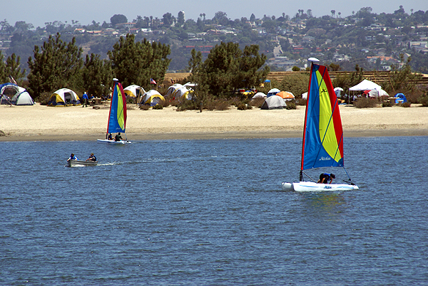 with some geocaching and made a day of it. We found the dashpoint, then headed for the flag. The flag was on Fiesta Island, a man made island in Mission Bay, which is where Sea World is located. In fact, when we pulled off the freeway, we exited on Sea World Drive, but went the opposite direction from Sea World.
The flag find was an easy find as were the caches today, but the island was a neat little adventure. Each cache was hidden in a similar fashion usually under a bush, however there were a couple of variations. We even had one cache that was guarded by an attack lizard. Not really, but I spotted this lizard on a branch and as I was watching the lizard, I also spotted the cache about a half an inch away from the lizard. Unfortunately, I got to close to the lizard with my camera before taking the picture 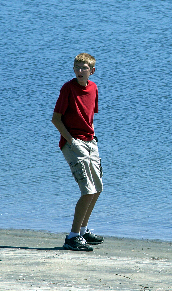 so there was a thousand words that got away.
Fiesta Island and nearby Dog Island are all connected, so I'm at a loss as to why one island is named differently depending upon which side of the island you're on, but I have a speculation. At one point while walking over to find our second cache of the day, I looked at the screen and the mapping software in my Garmin had us in the water. Not just near a shoreline, but totally in the water for at least 800 feet in all directions. Now, when I looked around, all I saw was land, but my GPSr was saying there should be water there, which leads me to believe that the part we were walking on was water at one time in the not so distant past and it has been filled in, thus rendering two islands into one.
When I started looking at this island yesterday in preparation for the today, I noticed a series of caches that had been temporarily disabled. Apparently, there is a big softball tournament on this island in July and the attendees get kind of rowdy. The cache owner of this set of caches temporarily disables his caches, and does maintenance on them during the month of July, then puts them back out again in August. Which means that we could come down here again in the fall perhaps and there will be a bunch more caches for us to find. That's always a plus, especially when you don't end up finding a couple in a given area.
The day was pretty much picture perfect. The Tadpole got to enjoy a secluded beach and toss a couple of stone in the water. The sail boats were out in force. We saw a couple of them tip over probably due to inexperience. These particular sail boats were on the small size from the looks of them, probably designed to teach sailors the ropes so to speak. Even the gulls seemed to be enjoying the day. The caches on the island varied in size from ammo can to small Tupperware type of containers. Overall, it was just a plain good day to be outside, enjoying the beach atmosphere and caching.
Pictures were taken at or near the following geocaches:
KITEBOARDING - by Splashman & Splashette
DRAGON'S FIESTA! - by DRAGONJD
GB #3 tanner_scout - by lulu499 and LegoCollin

Sunday, July 5, 2009
How in the heck....?
Every now and then when I'm geocaching, I stumble across something that just asks that questions, how in the heck did that get out there? You stand 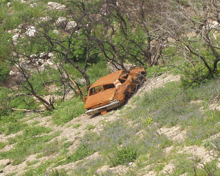 there and look and nothing really computes. Sometimes things can be explained. The cache we found a couple of weeks ago where we found the cache underneath the foundation of a house along a trail was easily explained when looking at the maps of the area afterwards. Those maps clearly delineated a road that wasn't there anymore, but obviously was there at one time.
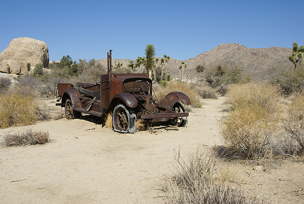 old prospector died. It's still junk, but because it's inside a national park now, it's "historic" junk and thus it stays rusting away. It tells an interesting story about the early history of the area in and around Joshua Tree. Old prospectors and homesteaders laid claims to lands everywhere in the west and some of their claims get documented in areas like this.
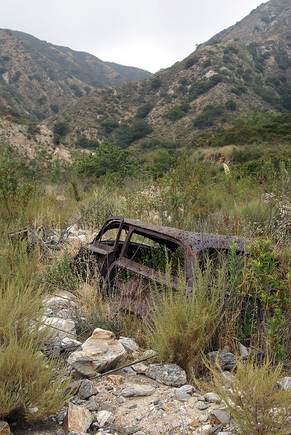 within the stream bed and had a difficult time getting up to the cache. How in the heck did that car get up there? At least it was serving some purpose up there, being a nice target, out of the way for gun toting individuals who needed some practice. We really couldn't tell, but it actually looked like a classic woody station wagon from the 1940s, one of those vintage cars that many of us drool over if we see them in museums or on the road. This one had definitely seen better days.
The hiders of these caches obviously knew about these abandoned automobiles. Names like Shades, Long Term Parking, and Dead Man's Truck, as well as Who Waxed Mr. Ed? give clues to where the cache might be, or what might be near the cache site. You still have to wonder sometimes how those things got out there.
Pictures were taken at or near the following geocaches:
Double Barrel Super-Soaker - by ohgr
Dead Man's Truck - by Land Snoopers [GC Charter Member]
Shades - by SHot70

Friday, July 3, 2009
Camping Trip
Planning has begun for our annual summer camping trip. This year there is a little bit of a twist to the entire trip, which is going to elongate it by about a week. Because of that, this will be the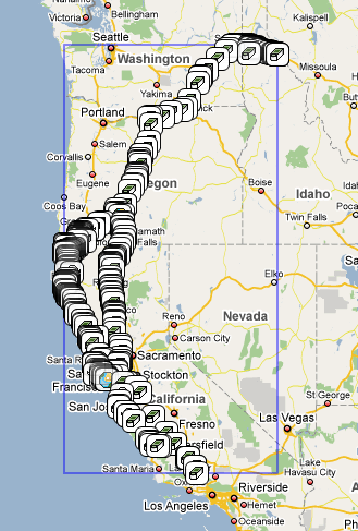 longest camping trip we've ever taken. Originally, the trip was going to be our basic one week trip. I actuallychronicled where we would be staying last year at about this time. Unfortunately, last year, the Tadpole got sick on the first night while camping in Marin County and we had to return home. We now believe that his illness was probably the precursor for his appendicitis which flared up in a major way last month.
 The pressing engagement on the far side of the camping trip was my older son's freshman orientation at UC Santa Cruz, scheduled for the 28. No matter what, if my dad came with us, we'd have to turn around about five days after getting up to Idaho.
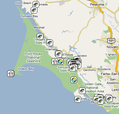

Wednesday, July 1, 2009
More History
Today the Tadpole and I decided to visit the Nixon Library. One of the draws was the "World's Largest 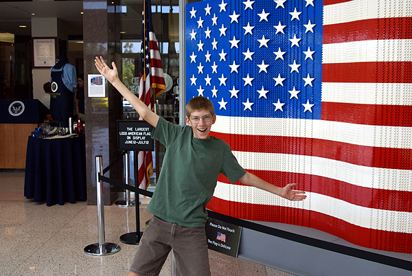 LEGO Flag" which was on display in the lobby of the Library. We found a couple of caches in the morning before getting there and then we found the parking lot for the library. We walked into the lobby of the library and there it was, a massive LEGO flag. It was rather impressive. I asked the Tadpole if he was ready to go and he gave me this quirky look as if to say, "What, are you kidding?" It was then he realized that I was.
We paid the admission price, spoke with a docent for a little bit to plan our day and then we were off to explore. Being early on a weekday, the place wasn't crowded at all so we decided to visit the President and Mrs. Nixon's graves first. I decided to take a couple of pictures, being fairly certain that Mrs. Nixon's grave hadn't been waymarked in the Grave of a Famous Person waymark category. I'm still waiting for approval on that particular waymark.
After paying our respects, we then headed over to his home where he was born and toured that and then it was off to walk through Marine One, the helicopter that 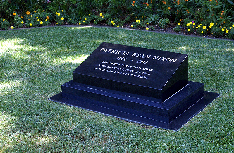 ferried four Presidents from Kennedy to Ford to and from the White House, Camp David and Andrews Air Force Base. This is the same helicopter you see in the famous picture when Nixon departed the White House for the last time in August 1974.
Then it was time to tour the museum. The museum has most of the factual parts of Nixon's life down and there are some interesting displays throughout. My favorite part is the hall of world leaders. In this room, there are life sized models of the world's leaders from Nixon's time as Vice President and President. This was the third time I'd been to the Library. The first time was a month after Nixon had died and the crowds were huge, so they had the area roped off, so you could only view them from afar.
Two years ago, my daughter and I revisited the library and that time we got to walk among the leaders.  There was Anwar Sadat speaking with Golda Meir. Winston Churchill, Charles DeGaulle and Conrad Adenauer of West Germany. Mao Zedung and Cho En Lai were represented as was Shigeru Yoshida, Prime Minister of Japan in the 40s and 50s. The last two statues were Leonid Brezhnev and Nikita Khrushchev. Growing up, many of these leaders I'd heard of were bigger than life in my mind and now I could walk among them.
The first thing that stands out is how short Nikita Khrushchev was. He was one of the most powerful men in the world and yet stood only 5 foot 4 inches tall, proving that size doesn't really matter. As you can see in the picture, he's several inches shorter than the Tadpole who stands 5 foot 7 inches tall. The next thing that stands out was how massive Charles DeGaulle was. Once again, compare his statue with the Tadpole standing right next to him. I estimate DeGaulle to be almost a foot taller than my son. DeGaulle was truly bigger than life.
Leaving this exhibit, we entered another exhibit that had several international exhibits including a segment of the Berlin 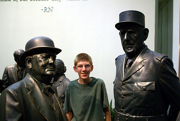 Wall. As soon as I saw it, I remembered seeing it two years ago with my daughter and had also remembered being a little confused because at that time, I thought the section was supposed to have been at the Reagan Library. The incongruity of the situation was something that my mind didn't really want to deal with, so I just put it out of my mind thinking that it was just one of those tricks my mind was playing on me. Somehow I must have made a mistake as to where the segment of the Berlin Wall was.
So today, I saw a second segment of the Berlin Wall, just about 10 days after seeing one at the Reagan Library. I knew for a fact that this segment at the Nixon Library hadn't been waymarked, so I took a picture. I'm not sure the picture is the best since I had to hand hold the camera as the library doesn't allow flash photography inside the building. But I now own two waymarks concerning the Berlin Wall, the Reagan segment which I waymarked last month and now the Nixon segment which was approved today in the Preserved Architectural Remnants and Ruins category.
At the moment, we have 12 Presidential libraries, one for every President from Hoover through Clinton. 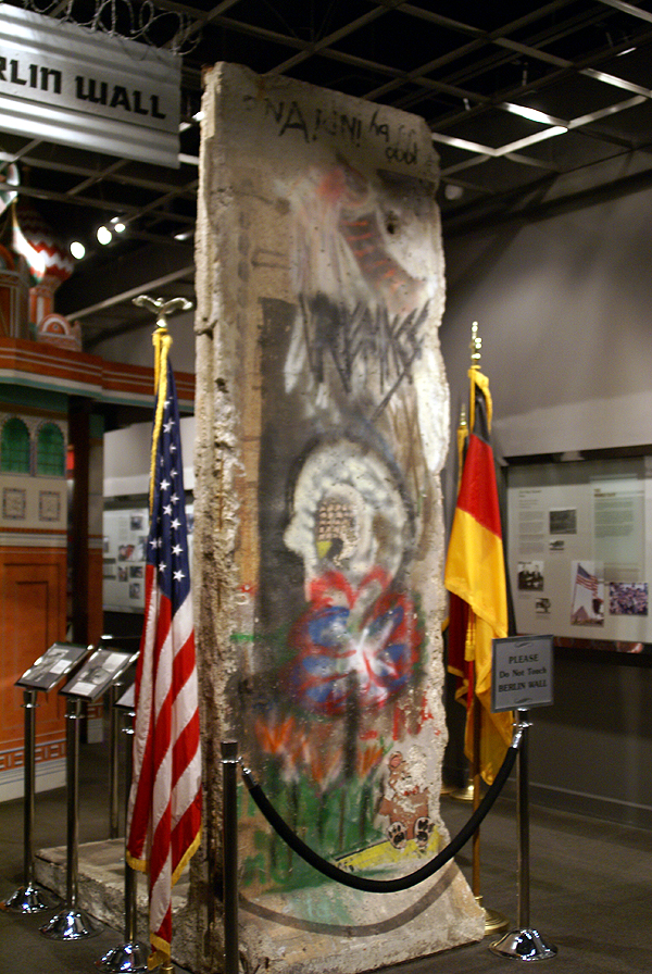 With the addition of George W. Bush's library (#13), only Texas will have more Presidential Libraries than California. But I think California has the two that are closest together geographically. That has been an added bonus for this history buff and the history buff who calls himself the Tadpole. Both of the libraries have some interesting features but overall, I'd say the Reagan library was a little bit better put together. I think part of this was there was a lot of updating to exhibits going on in the Nixon Library.
Before the National Archives took over the Nixon Library in 2007, there wasn't a lot of information on Watergate in the Nixon library. They'd started changing this when I was there two years ago with my daughter, but they still have a lot to do before it's complete. One piece of paper in this part of museum was very striking in its simplicity and that was Nixon's resignation letter to the Secretary of State, Henry Kissinger. It simply stated, " I hereby resign the office of President of the United States." Dated August 9th, 1974, it was received and initialed by the Secretary of State at 11:35 AM. Interesting how simple the transfer of power can happen in our country.
Pictures were taken at or near the following waymarks:
Berlin Wall Segment - Richard Nixon Presidential Library
