Tomorrow, the Tadpole and I will head out for our annual summer vacation camping trip. 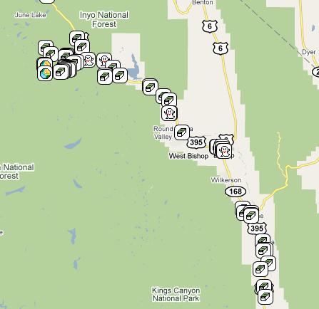 I have been camping with many different combinations of my kids every summer and sometimes during spring break for the past 16 years. We missed two summers, one due to circumstances beyond our control and the other because the Tadpole got sick on the first day, so we actually did camp that year, but only for one day.
This year, our trip is going to take us all the way to Northern California, not as far as last year when we got all the way to the panhandle of Idaho and into Montana, but still a good distance. Our first stop is Devils Postpile National Monument on the eastern side of the Sierra Nevada. The last time I was at the Postpile was the week Elvis died (1977 for those of you who aren't old enough to remember). We'd been backpacking in the area and had stopped at the Postpile at the beginning of our trek. At the end, we stopped in Bishop, California for lunch which is when we found out that Elvis had died.
I can remember taking a picture of a pine tree about a foot tall growing out of a crack in the top of the postpile. One of the things I'd like to see is how tall that tree has grown if it's survived. There are also extensive hiking trails in the area and we plan on taking advantage of these while we geocache.
From there, we will head up to Lassen Volcanic National Park.  I have been camping in Lassen at least four times in the past, however the Tadpole has never been there. There were several things that I wanted to take him to see, including a possible trip up to the top of the mountain. The trail is fairly rigorous going to the top, but I'm pretty sure he'll be able to handle it this year. However, this year, the entire west coast got a lot of rainfall, and thus in the higher elevations, a lot of snow. The road through the park is still closed as they continue to work on snow removal. I have serious doubts as to whether we'll be able to make it to the summit.
There are also thermal areas in the park, one near the south entrance and one further in along the southern entrance. If the snow is still blocking the road, we may have to drive around to get to these areas, but it's something that's fairly unique to the park and I'd like him to see at least one of these. One day while we're camping there, we also plan on driving up to Lava Beds National Monument.
This area has more volcanic activity, similar to Lassen, yet different. If you were to look on a map of the United States, you could trace a line from Lava Beds, up to Yellowstone in Wyoming. The line would also run through Craters of the Moon in Idaho. All three areas are volcanic and are theorized to be created by a hot spot in the mantle of the earth. As the North American tectonic plate moved over this hot spot, lava oozed to the surface or nearly to the surface, and caused many of the features that can be seen in these three parks.
 Currently, the hot spot is under Yellowstone, but in the near future (geologicially speaking) it will move beyond that and many of Yellowstone's current features will cease to exist because there won't be heat under them to help them to continue, including Old Faithful Geyser. If this theory holds up, our descendants can expect to see a new volcanic area forming to the northeast of Yellowstone. It's pretty cool to think about.
Lava Beds National Monument, besides the geologic history, also has some cultural history. It is the site of the Modoc Wars between Federal Cavalry troops and the Modoc Indian. Outnumbered 5 to 1, the Modocs managed to hold out for over five months in this region during 1872-73 because they knew the lay of the land much better than the cavalry that was trying to remove them from the area.
In all of the years I've been camping, I don't believe we've ever been away from home for the 4th of July. The town where we currently live has an annual parade down the main street, followed by speeches in the park and a fireworks show that evening. We'll probably drive near Redding, California just west of Lassen to view their fireworks display.
The next day, we plan to drive into town and visit the Turtle Bay Museum, where a GPS Maze exhibit will be this entire summer. When we discovered that this maze was going to be in Redding, we both decided that we wanted to go and see it. 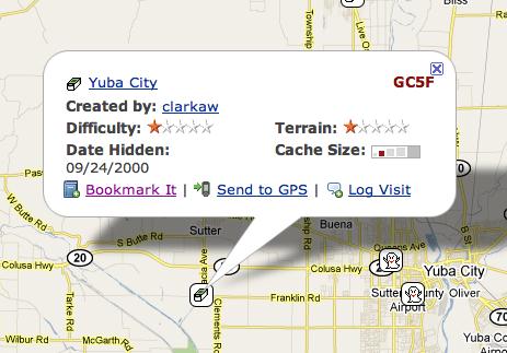 It doesn't look like it will be coming to the Southern California area any time in the near future, so this would possibly be our only opportunity to see one of these. I believe there's one happening currently in Baltimore, Maryland.
The last two days of our trip will be spent driving home, with a stop in Stockton, about midway between Lassen and home to visit my daughter, Tadpole's sister. On the way, we plan at least one detour in Yuba City to find this cache. Yuba City cache is the second oldest active cache in California, hidden in September 2000, almost 10 years ago. It's so old that it only carries two digits after it's GC designation symbol. It will definitely be the oldest cache I've ever found since starting this hobby.
This will be my last post for about a week, unless I can find a WiFi hotspot somewhere in Redding and can make a quick post, but I seriously doubt that will happen. Besides, I will be on vacation, so I'm not really planning on checking in until after I get home. Have fun in the meantime.
Monday, June 28, 2010
Camping this summer

Thursday, June 24, 2010
Butterflies are free to fly
 As you've probably guessed by now, I like to take pictures when I'm out geocaching. I don't necessarily take pictures every time I geocache, but when there's a hike involved, I'll usually have my camera along with me. One of my favorite subjects to take pictures of are butterflies.
I guess you could say I'm an amateur lepidopterologist. When I see a butterfly in the field, I usually watch it for several minutes in the hopes that it will alight somewhere and pose for me so I can take a picture of it. As a youngster, I can remember watching small yellow butterflies that were very common around my house. I had been told that these particular ones were moths, but I have since learned they are actually a type of skipper.
Since I had only seen these types of insects during the day, it made sense for them to be butterflies, as they are usually active during the day, while moths tend to be active at night. And that makes it nice to take pictures of butterflies, because they're out when I'm out. Back in December, I wrote about one of the Monarch wintering grounds near Pismo Beach, California. I can honestly say I've never seen so many Monarchs in one place ever.
I can remember growing up, reading about the Monarch butterfly and thinking if I'd ever get the chance to see one.  Living in California, I had a good chance, but the opportunity never seemed to arise and I figured it was going to be one of those elusive creatures that I would never get to see except at a laboratory specimen. Then, one year while on our annual summer camping trip, I spotted one in Kings Canyon National Park in Zumwalt Meadows along a nature trail. I have seen many Monarchs since then, including one while out hiding my latest cache.
The interesting thing about butterfly identification is it's not an exact science. I tend to use this site as my guide when I'm trying to identify a butterfly. When I saw the Western Checkerspot on a trail hike last month, I was surprised to find that it could have been one of about four different subspecies.
There was another time while doing the Groundspeak series of caches when I spotted a pretty small green butterfly. It was late in the evening, so it was looking for a spot to rest of up for the night. When it found a spot, it folded up its wings and settled in. That didn't help with the identification, since much of the identity of a butterfly is on its top wings. The best I could do with that one was to narrow it down to either a Desert Marble or perhaps a California Marble. Once again, the identification guide is not fool proof, but it gave me a pretty good idea of what I was looking at.
These pictures here represent just a small portion of the butterflies I've seen in my lifetime. I have not been able to photograph them all, nor will I ever. I just think they're interesting to look at and I find it kind of neat to be able to note that the swallowtail isn't just a swallowtail, but a Pale Swallowtail.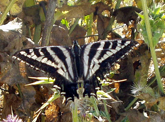
Pictures were taken at or near the following geocaches:
East Canyon Above and Beyond the Meadow - by SnakeSpotter
Micro N Post - by not tom
Carpe Diem! - by HaZaMaTt...

Tuesday, June 22, 2010
Kill Bill meets an Elephant
A couple of months ago, I posted about simulacra, the waymark where inanimate objects look like real live things. Earlier this month, I was out in the desert finding a multi-cache. The cache was a simple offset, where you find something, or go to a set of coordinates and then walk a certain direction away from those coordinates to find the cache.  I've created a cache similar to that, but I've turned it around and make the finder project a waypoint out and then head to those coordinates to get the final.
The original spot, as stated on the cache page, was at a sleeping elephant. OK now. Give me a break. A sleeping elephant out in the desert of California. Maybe in Africa, but not here. Whoa! Yep, that's a sleeping baby elephant all right. Besides finding this cache, it also gave me the opportunity to post a waymark in the simulacra category for a sleeping baby elephant. An added bonus was also posting a waymark in the movie scenes catergory, since the title of the cache is called Kill Bill's Church. The church across the street from the elephant was used in the Kill Bill movies.
I always enjoy stumbling across stuff like this. I was actually surprised that neither spot had previously been waymarked. With the title of the movie as part of the cache description, one would think that some other geocacher would have thought to look on waymarking.com and done a search for it. I did and found the nearest waymark to be 16.1 miles north of the spot, which gave me a pretty good indication that neither had been waymarked.
The problem, as I see it with waymarking, is you really don't know what's out there until start clicking on links on the geocaching site. I have never been able to find an easy way to navigate around on the waymarking site. When I wanted to waymark the piece of the Berlin Wall that's standing at the Reagan Library in Simi Valley, I wasn't sure where to start. I think I started with a search of Berlin Wall. Eventually, I figured that it would best fit in the Preserved Architectural Remnants and Ruins section.  Once a category is found, it's pretty easy to submit a waymark and the people who help approve the waymarks are pretty good about steering you to the right spot if you haven't quite got it, but I still think it should be easier.
I'm sure I could probably do a lot more waymarking than I do, but I don't know the criteria for each category. There's almost 1000 different categories of different things, so for the most part, I stick to what interests me and stay there, although the movie category isn't one of the categories I usually end up submitting waymarks to, the Kill Bill Church being the first one. I just happened to get lucky that I had taken a picture and had all the requisite information for the submission.
I sometimes think that since the removal of virtual caches from Geocaching, Waymarking has become the ugly stepsister of Geocaching. They're not really sure what to do with it and so it just sits there, getting bigger, but not really improving in any way. The geocaching site gets makeovers on a regular basis, but I don't see that happening on the Waymarking site. That's a shame, as I think the site could be better utilized if it were better organized. But then again, perhaps that's the best it can be, because of the scope of it.
Pictures were taken at or near the following geocache:
KILL BILL'S CHURCH - by fear it caches

Tuesday, June 15, 2010
It's the wrong one people...
While on the road trip this weekend, I found a cache that had a benchmark nearby. The cache page even stated there was a benchmark nearby. As I've stated numerous times in the past, I usually don't go hunting benchmarks, but if they present themselves to me, I'll log them.
The Altamount Silo find was sort of like a comedy of errors. 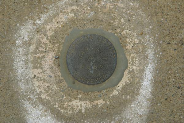 First, I didn't believe the GPSr when it said over there. Nope, my geosenses were saying it should be here, so that's where I'm going to look first, foxtails be damned. Yeah, well with that much open sky, I should have trusted the GPSr, because it led me right to the cache. After making my trade at the cache, I headed back to my van to get my camera to photograph the benchmark. Why I didn't bring it along, I don't know, because I knew I was going to have to take some pictures at this cache site.
The benchmark page at Geocaching.com is pretty specific on how to log a benchmark. Unfortunately, they don't require a picture of the benchmark in order to log it, which in my opinion is wrong. The picture backs up the find and also points out possible errors, should the person get the wrong benchmark. There is another section on the benchmark page that educates people on whether they have the correct benchmark or not.
This particular benchmark is supposedly very close to the Altamount Silo Geocache. Looking at the two maps, they are indeed very close, but if someone is going to log that benchmark, they really need to find it first. I didn't and realized it as soon I got home and looked at my pictures. The designation for the benchmark is K 1258. That means you're going to see those combination of letters and numbers are going to be stamped into the benchmark somewhere, especially if it's a disk.
When I got home and looked at my picture of the disk, I noticed that it was clearly labeled Alameda County Surveyor around the outside of the disk and CAR-ALT and 1994 stamped in the middle. Anyone, who had taken the time to read the benchmark description page would have noticed the discrepancy in the designations, plus the other clue of the date. The 1994 date on the disk doesn't match the description of the other disk, which was set in 1974, twenty years earlier.
The sad thing is people are still logging the benchmark as found. I'm not a serious benchmarker by any stretch of the imagination, but I can imagine that this would frustrate people who are. They might plan a trip out there, then realize that the disk isn't the correct one. 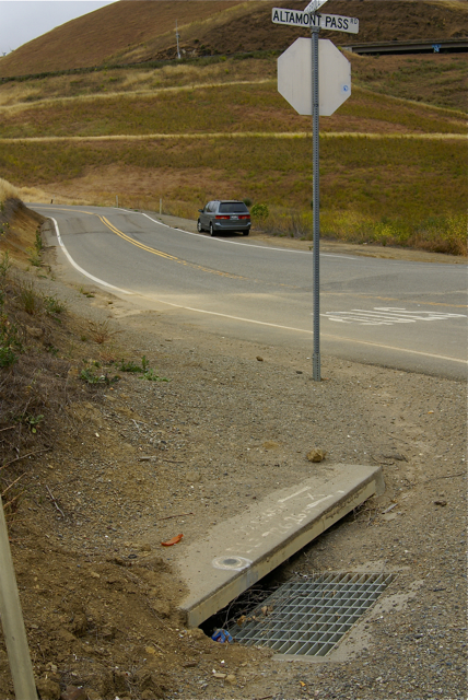 What's even sadder, in my opinion, is there have been people who have pointed out on the benchmark page, that the disk that is being logged isn't the correct one. This was done early in 2005. Since that time it has been logged as "found" by six other geocachers. Two other notes have also been posted stating the benchmark they are finding isn't the correct one.
Maybe I'm picking nits on this one, since it's just a small aspect of the overall hobby, but there's something wrong with claiming a find when you haven't found it. I think partial responsibility rests with geocaching.com. If they're going to list this on their site, then they should police that area, but that's not happening. And so, people are being misled.
And the flip side of this is, don't know that this disk is the wrong one. I didn't until I got home. The difference is, I checked before I logged it, realized that it wasn't the correct one, and so didn't log it. Others are following through like that. I guess I'm hoping for a perfect world where everything runs, uh, . . . yeah, perfectly. All caches would be found, benchmarks would be logged accurately, people wouldn't lose their GPrs, and gas would only cost 35¢ per gallon. Well, we know that's not going to happen, but I think I just needed to get that off my chest anyway.
Oh, and when I got back to the van and got ready to take off, I realized that I didn't have my GPSr with me. I checked the van thoroughly and didn't find it there, so I went back to the cache and found it lying on the ground about four feet away. Usually, when I find a cache, I place my GPSr on the top of my foot, since it's likely that were I to walk off, I'd feel it fall off of my foot and remember that I need to pick it up. For whatever reason, this system failed me this time. At least I wasn't 20 miles down the road before I realized it though.
Pictures were taken at or near the following geocache:
Altamount Silo - by Kenny162

Saturday, June 12, 2010
A rose by any other name...
This past week, I went on a short road trip to Northern California. I know short is a relative term, but it was short for me in time, as opposed to distance since I put slightly over 1000 miles on the van, plus added two new front tires during the trip.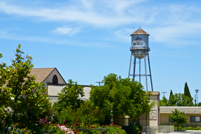
I drove up to Stockton, mainly to deliver extra "stuff" to my daughter, including a couch that she'd gotten from her grandmother, but couldn't fit in her car. There would be a side trip to Santa Cruz to pick up my son as well. Since he wanted to visit with his sister for a little bit, I picked him up, then drove back over to Stockton. This should have been a 4 hour round trip, but it ended up being over 8 hours because a problem developed on one of the front tires and I had to get that fixed before we could head back. Things happen and there's not much I could do about that.
Each time I drive up there, I try to take different routes. I look at the different virtual flags that can be captured, as well as any possible dashpoints, plus geocaches and then I plan my route accordingly. Waymarks and benchmarks are side possibilities, but for those, I just let them happen as opposed to me actively search for them.
If you've followed this blog for any length of time, you know that my most active waymark category is water towers. I love driving into small towns and seeing their town advertised for miles by the large water tower in the center of town. We have few water towers in Southern California, as most municipalities build large storage tanks in the hills above town which provides the same purpose of creating water pressure for the town's water supply.
Towns in the Central Valley of California and elsewhere where no hills are present create their town's water pressure by building water towers. Usually, these water towers promote the city, but some support advertisements for local businesses. The main water tower in Merced, California promotes the newest university in the UC system, UC Merced.
As I drove through the Central Valley this week, I happened to drive through the town of Wasco, CA. I've seen signs pointing to Wasco while driving both Hwy 99 and I-5, but have never gotten off, mainly because the town is out of the way. 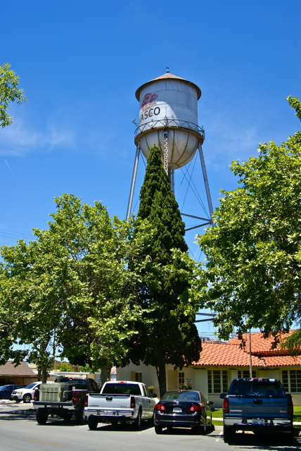 I've actually wanted to either stop in the town, or at least, stop and take a picture of a sign with Wasco on it, mainly because a geocacher, whom I consider a good friend and have met, goes by the name WascoZooKeeper.
Had I known a little bit about the town, I might have been tempted to stop there sooner. Wasco bills itself as the Rose Capital of the World. Every year it has a rose festival the weekend after Labor Day weekend and the water tower in the middle of town is plastered with a large red rose. After getting home, I discovered that 55% of all roses grown in the United States are grown in and around Wasco by nine major rose companies. It was a pleasant experience to drive through the fields around town and see rows and rows of red roses, then rows of yellow roses. I know I've never seen so many roses in one place before.
If not for the GPS games that I play, I probably would have never passed through this quaint little town. I feel, I'm richer in spirit because of this hobby. If you happen to be in the area on the weekend after Labor Day some year, I think you could do worse than to make a stop in Wasco and take in their Rose Festival.
Pictures taken at the Wasco Water Tower:

Thursday, June 3, 2010
Where is that thing?
Every now and then, I will come upon a cache that I feel is just well done. That was the case last weekend with East Canyon Log-In. The coordinates were slightly off on this particular cache, but being thirty to fifty feet off in a rural setting is a lot different in many ways to being the same distance off in an urban setting.  Some will argue that the urban setting would be easier in that instance while, I'm sure, others would argue the other way around.
What helps is the cache page write up, which is one of the reasons I really liked this particular cache. If you go to the cache page, you'll notice that I've placed it on my top 5% list. Making my list in no way implies that the cache is a great cache. It only means, that in some small way, it either tickled my fancy, or I felt it was creative in some way. This one, I think, did both.
The cache itself, is a small jar, which would be difficult to spot in thigh high foxtails and thistles. However, the cache page write is very much like a decrypted hint in helping the finder find the cache. I'm not saying that's necessary all the time, but it sure is helpful, especially when you have tree cover that reduces the accuracy of the GPSr in your hand.
The second part of this cache that I really liked was the cache container. As stated is was a small jar, but what way the jar was incorporated with the surrounding environment helped get this cache onto my list. I actually would have wanted to be a fly on the nearest tree when the cache hiders brought this cache here. I think it would have been very entertaining.
The only other question I have is, where do you think the cache is hidden? It might be obvious, or it might not be.
On a side note. Some of you might have noticed that I've gone to moderated comments. I have done that because recently, I have been getting spam comments. Obviously, the person who has been doing this hasn't gotten the message and continues to post links to pages that I would find objectionable if my youngest were to click on them. Since he reads this column from time to time, I felt it necessary to go to moderated comments. To that person - if you continue to reply to this blog with links to semi-pornographic sites with no other intent other than to generate traffic to your own site, your posts will continue to be summarily rejected. I apologize to my other readers for this action, but I feel it is necessary to keep this a family friendly blog.
Picture was taken near East Canyon Log-In - by BearandDirtybird
