My dog Jack, is not one who's very good at long walks. We've walked him down into village area of our town, which is about three quarters of a mile away and he's really tired about halfway back from there. 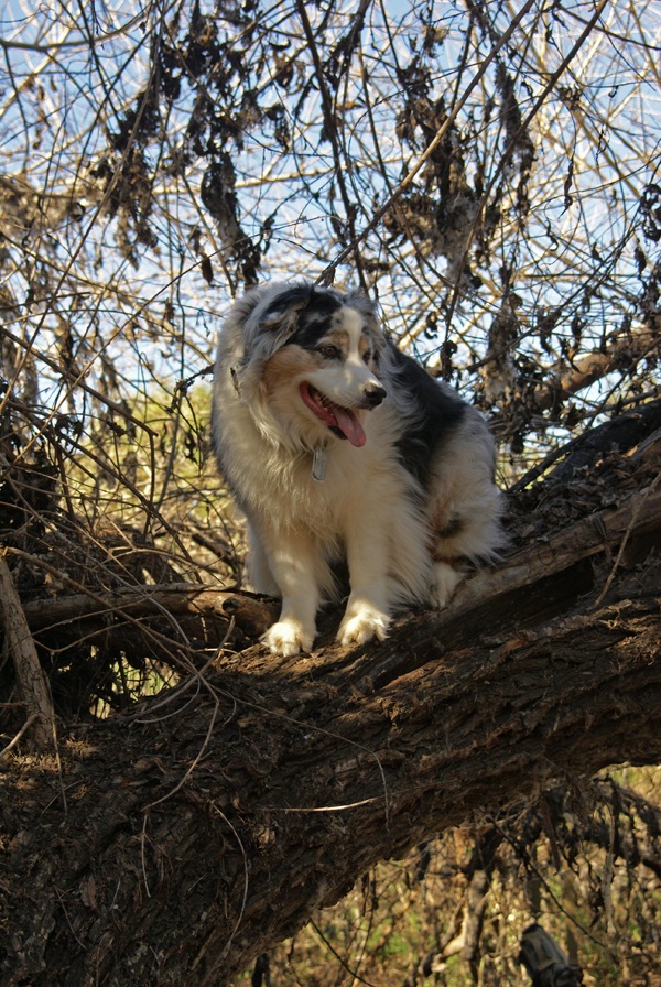 For him, that's a long walk, but then again, he's a smaller dog and those little legs just keep churning along, but he's also the kind of dog who will just shut down, lie down and say, enough, I'm tired. Needless to say, I don't take him with me too often when I cache, although, he does have his own Geocaching account and has logged 10 finds.
I have been hiking and caching with others who bring their dogs along for the trek. All of these dogs have been much larger than Jack, probably outweighing him by fifty pounds or so. I would think a larger dog has more stamina for hikes of several miles. The last thing I'd want to do is have to lug around a dog who just refuses to walk any more. That would be tough, especially if you're miles from transportation or only midway through your caching day.
Most of the time, the dogs are just with us because they like to be outdoors with their companions and they love to run and/or go for along walk. All of our walks with dogs have usually been over a couple of miles. Yeah, they get tired at the end, but they always seem to have extra energy, much more than I can say for me after some of our hikes. It would be nice to have that kind of stamina.
When you're caching with dogs, you have a different mind set as well. You're constantly on the lookout for them, making sure they're not getting into trouble. Then again, sometimes, they just need to explore, like Sheila did last week when she decided to climb that tree. The cache was there, just not up that high. But she had the right idea for the most part.
Another thing to like about dogs is they don't eat very much while on the trail and if you have the right equipment, they'll even carry their own gear. One dog I went on a hike with had his own saddlebags for carrying his own water and everything else he needed for the day trek we had planned. All you really need is a good container to use for a water bowl and you're really good to go with a dog.
The other thing I've noticed about dogs is they're smart enough to rest in the shade. I'm pretty sure what goes through a dog's mind is something like this.
"Oh boy, I'm going on a walk with food guy!! Walk, walk, walk, pant, pant. Run, run. Oooooh. There's lots of good smells on this trail. SQUIRREL!!!! C'mon Food Guy, let's go!! You're going too slow for me. Oh, wait, you're looking for that geohiddenthingamabob aren't you? That's OK with me. I get to rest and relax in the shade while you look. I hope it's a difficulty Five. That way I get to rest for a good long while, cause I know you're not that good at finding those geohiddenthingamabobs. SQUIRREL!!!"
You know, you can stop me at any time, because I could probably go on for a long time like that. I'll leave you with one more short story before I sign off today. 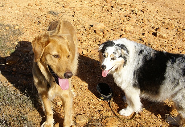 There was a cacher in the San Diego area who went by the handle Yrium. He took his dog with him on many of his caching outings. Several of Yrium's logs were written in the style I posted above, as if his dog had written them. They were some of the best logs I'd read and always seemed to bring a smile to my face.
Unfortunately, Yrium passed away a couple of years ago after a battle with cancer. Although I'd never met him face to face, we'd written emails back and forth, played fantasy baseball together, and so I felt like I knew a little about the man. Every time I log a cache for Jack my dog, I try to write it in the style that Yrium used to write for his dog and then I dedicate the log to Yrium's memory.
This past month, my friend Craig and his other companion Sheila lost their third companion Gromit. He's on the left in the second picture. Gromit went way too early in either people or dog years. He was a good companion and a good trail walker. He will be surely missed. This blog entry is respectfully dedicated in memory of Gromit.
Pictures were taken at the following geocaches:
Leaf Me Alone - by Whinger
Jumping to Conclusions - by Webfoot
Sunday, January 30, 2011
Caching with dogs

Wednesday, January 26, 2011
Wordless Wednesday

Sunday, January 23, 2011
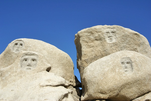
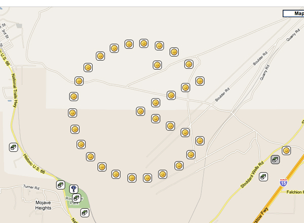
Another picture in the desert
Last Monday, I headed out to the desert to finish up another series of geocaches patterned after the PacMan figure. We'd actually started the series in December, but weren't able to complete the entire series because it had been raining most of the day out there. The last ten caches were located in very rocky areas and we didn't want to risk injury due to a slip on wet surfaces, so we waited until better weather to finish it off.
 The holiday last weekend provided the best opportunity to finish up the series, so out we drove. We had two different spots to fix, so we drove down to one of the other caches we'd already found, then shuttled over to the back of the head. From there, it was just a nice hike to pick up the six we'd missed in that direction.
After lunch, we drove over to another starting spot, hiked up to the cache at the top of the head, then made our way over to the west to get the others. Hiking in a counter clockwise direction, we found an easy path amongst the boulders down to the road. We kept looking behind us and were having a hard time picking out our route we'd traveled down. This was the same dilemma we'd had on the 18th of December. We couldn't see a sensible route up. We really had made the correct decision to hike those last four in the opposite way than we thought about doing them.
What this all really means is I've had a decent start to the new year as far as caching goes. I'm averaging right now, slightly over a cache per day. Last year I averaged over 2 per day. My average will go up as we get into warmer weather, but I'm really not concerned about how many I average, but whether I have fun. And, I have another picture in the desert. I already had a Smiley, which is located just to the east of the PacMan. Then last year in April, we completed the Groundspeak Series. Next up on our list, whether it happens this year, or possibly next year is a giant Kokopeli located in the southwest corner of Utah. That one looks to be about a three day adventure, so we'll have to plan this one as an overnighter, possibly camping trip. It should be fun.

Wednesday, January 12, 2011
Wordless Wednesday
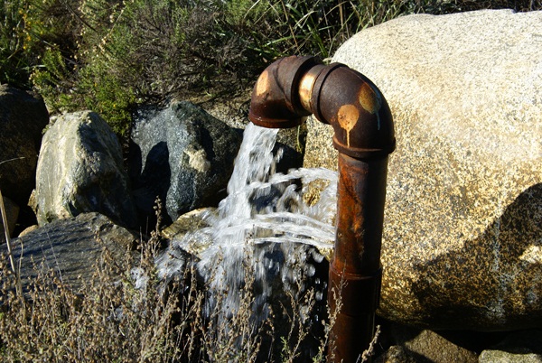
It's a gusher!

Sunday, January 9, 2011
Calibration
Last week, on my hike in the North Etiwanda Preserve (NEP), I tried calibrating my GPSr. 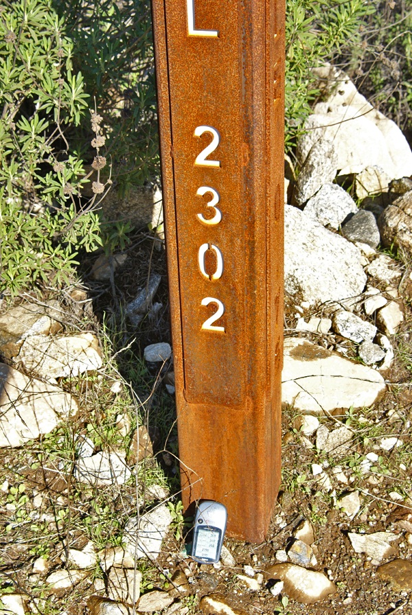 Not that I really could calibrate it accurately, but I tried to see how accurate it was compared to the adjacent signage. Usually, when I'm out geocaching, I don't need to take any kind of altitude readings with my GPSr. In my opinion, I believe that most of that handheld models are accurate to a certain degree, but not accurate enough for anything outside of fun and games.
When Chaosmanor and I hiked to the top of Simi Peak back in November, I put my GPSr on top of the bucket on the peak that held a laminated piece of paper stating the height of the peak, 2403 feet in elevation. I just wanted to see if my GPSr would register the same. It did, after a fashion. We actually watched the number start out at a lower elevation and then watched as the number climbed up to 2403 feet, which was when I snapped the picture. I suppose that if we were willing to wait several minutes of battery life, the unit would have settled down and produced a constant elevation. I might have to try that sometime, but it's not high on my list of priorities.
The NEP has mile markers every quarter of a mile. Those mile markers also indicate the elevation at the point as well. The last time I'd been hiking in the preserve, over a year ago, I did the same thing and got the exact result. This time, the result was four feet different than what the sign post said. After taking the picture, I picked my GPSr up and it immediately registered the "correct" elevation. Then again, does the elevation listed on the marker indicate the elevation at the top of the pole, or at ground level? My assumption would be that it should be a ground level.
Picking up my GPSr, actually brought it up to the top of the pole, which would have been the four feet difference, but once again, it's readily apparent that these gizmos shouldn't really be used for super accurate measurement of elevation or of latitude and longitude. And yes, I'm writing this all with tongue firmly planted in cheek this morning. After all, it's just a game we're playing out here.
Picture was taken near the following geocache:
NEP on the Rocks - by maddmaxxawr