With January finished tonight, I ended up with 38 cache finds for the month, averaging slightly more than a cache find per day. Most of those were on a couple of cache runs on a the weekends, so it was not a sustained cache streak.  I did that one other time, finding a cache for 56 days in a row. I will never do that again. It was exhausting and not much fun near the end.
There weren't many longish hikes during this month, mainly because weather didn't cooperate much this past month and because caching has evolved as a hobby and sport over the past 9 years. Back in the "olden" days, the majority of caches were placed on trails, far from civilization. You'd hike to a cache, find that one cache and you were done for the day. With so few cachers around, this was to be expected.
I didn't hide my first cache until four months after I'd started finding caches. I learned from others and how they hid caches. Since most cache hides were hikes, hidden away from the crowds, that's what I decided to do as well. Today, it's different.
Now, caches are hidden everywhere, on almost every street corner and every Wal-Mart parking lot. The lamppost hide, which has become rampant, was original at one time. I remember trying to find my first lamppost cache hide. It was hidden at the exit of a drive through of a burger place, not the best placement in my opinion, especially at lunchtime.  It took me three tries at this cache before I "got" it. Now, if many of us were to be led to a lamppost today, probably the first thing we'd do, would be to lift the skirt of the lamppost.
Many of the trails around here have caches hidden on them, many of them my own caches. I don't hide micros, and most of my caches, a hike is needed to get to them. That's the way I learned about caching and that's the way I'll proceed. And no, I'm not above finding a micro or two or three from time to time, but every now and then, I need a hike like I took several years ago up to the top of Potato Mountain.
The hike took me beyond the spots where my furthest two caches, Black Friday and The Cats Made Me Do It, have been hidden. To get to the top of Potato Mountain, which is actually a smallish hill, the hike is probably a four mile hike from the parking lot down in the flat lands. It's a killer hike, but the reward is great. From on top, you have views of the mountains beyond, the valley below and on exceptionally clear days, you could probably see all the way out to Catalina Island, 24 miles away from the coast of California.
Back then it was simple. A four mile hike, one cache and a day well spent. Now? It's different. Some would say different in a bad way. I say, it's just different. We all get out of the hobby what we put into it. If I choose to go on a hike, I can do so. If I choose to hunt micros on a particular day, that's also my choice. 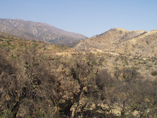 To whine about "micro-spew" does everyone a disservice and serves no purpose except to develop discontent among the geocaching community. I am probably guilty from time to time of sniping about the proliferation of micros and lamppost hides. Sometimes it's easy to get caught up in the debate of the day. In the future, I will try to remember what I've written here.
Pictures were taken at or near the following geocaches:
Potato Mountain Flat Place Reminiscence #1 - by Carharty
Scenic Value - by Webfoot
Trail Junction Cache - by catrunr
Sunday, January 31, 2010
The long and winding trail

Thursday, January 28, 2010
None but the Brave
Last Saturday, after visiting my mom in the hospital, we headed east out to Riverside National Cemetery. A little over a year ago, I'd been out in the same general area, getting a virtual near March ARB. 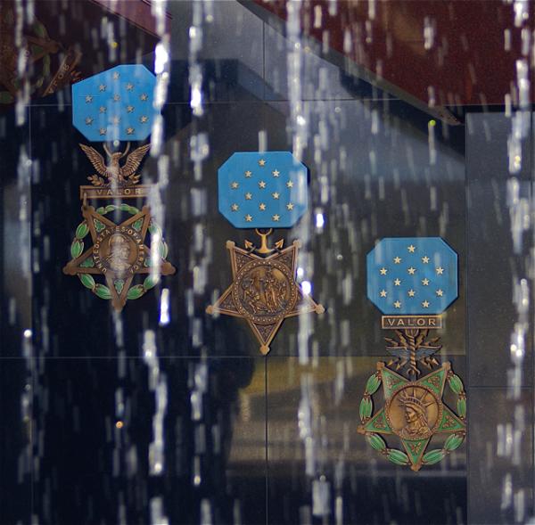 The National Cemetery, was just to the west of the Air Base, on the other side of the 215 freeway in Riverside. I had to cut my caching trip short that day, because of extenuating circumstances, so I wasn't able to go after another virtual cache at the Cemetery. Fortunately, the Tadpole and I were able to get that particular cache on Saturday.
When we went out there, I was basically unaware of what we were going to be looking for, so I just followed the GPSr to ground zero. It became rather apparent the closer we got. There were signs pointing the way to the Medal of Honor Memorial. This particular memorial, is one of the four official Medal of Honor Memorials located in the United States, which honor all 3000+ Medal of Honor award winners since the inception of the award in 1862.
For the uninitiated, the Medal of Honor is the highest award that can be achieved by any person employed in the armed services for the United States. It is sometimes called the Congressional Medal of Honor, but that is a misnomer. The correct term is just Medal of Honor. There are three different medals, depending upon which branch of service the soldier/sailor is a part. I'm not sure, but I think one of the attributes of the "official" designation of these memorials is that every person awarded the medal has their named engraved in the memorial.
The other three memorials are located in Pueblo, Colorado, Indianapolis, Indiana and Charleston, South Carolina aboard the U.S.S. Yorktown, which is moored in Charleston Harbor. 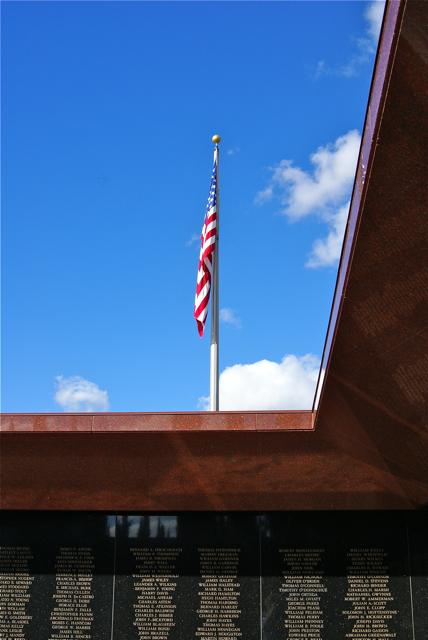 The layout of the memorial in Riverside is in the form of a cross, when viewed from satellite images. Walking up to the memorial takes you past the seals of the different branches of the armed services. The entrance is guarded by two large reddish brown granite monoliths, which introduce the visitor to the Medal of Honor Memorial, with the western monolith giving the basic criteria for earning a Medal of Honor, that of "conspicuous gallantry and interpidity at the risk of life above and beyond the call of duty."
The center of the memorial is a pool with cascading water. The water is pumped into a steel rail that is over the top of the pool and water drops from that rail into the pool. I was so engrossed in other aspects of the memorial, that I failed to even look at how the rail was supported over the pool. From the entrance, we could look through the water dripping down and see large replicas of the Medal of Honor for each branch of service, from left to right in the picture: Army, Navy, Air Force.
Once inside, the litany of names were engraved on granite walls all around the fountain, starting with winners from the Civil War, all the way around to the two latest from the conflict in Afghanistan. Due to the nature and criteria of the award, 60% of the award receivers are awarded their medal posthumously.
While getting the information needed for the virtual cache, we ended up going all around the memorial. We'd have done this anyway and I think we spent a good half hour just in awe of all these brave men, many of whom gave their life for their country. There were more Civil War veterans listed than any other war, mostly due to looser conditions for the awarding of the medal in the first place. I'll not quibble with anyone who is on that wall.
As we walked around, I looked for certain people that I was pretty sure were on the wall. I missed Audie Murphy's name, he being the most decorated soldier in American History, but I was able to find Joshua Chamberlain's name. 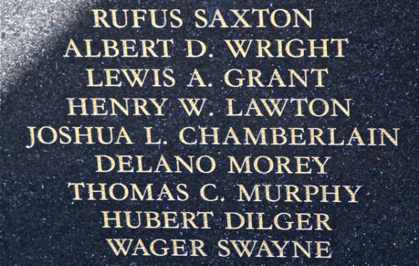 Chamberlain commanded the 20th Main Infantry which prevented the Confederate troops from flanking the Union line at Little Round Top during the Battle of Gettysburg on July 2nd, 1863. Chamberlain later went on to serve 4 one-year terms as Governor of Maine and would later serve as President of Bowdoin College, his alma mater. He is featured prominently in the movie, Gettysburg, played by Jeff Daniels.
We also found several servicemen with our surname, plus one of my admired Presidents, Theodore Roosevelt. On another panel, in another war, was Roosevelt's son, Theodore Jr. The stories on those walls were endless. I left thinking that I was glad that I hadn't been able to get this virtual a year ago because the Tadpole would have missed the experience. Although, I'm pretty sure that I would have taken him back here because he needed to see this. I'm hoping he'll understand what this was all about in the future.
The encouraging thing about these four memorials is they are spread across the country in a way that almost all Americans living in the contiguous United States are only about a day's drive away from one of the memorials. Unlike many of the memorials in a city like Washington D.C., where there is only one, people don't have to travel long distances to appreciate the sacrifices made by these men. In my opinion, that's a good thing.
Pictures were taken at or near the following geocache:
Bravest of the Brave - by SlowMover

Sunday, January 24, 2010
Weekend Respite
With over 7 inches of rain falling in the Southern California area over the past week, the weekend dawned bright, and for the most part sunny. There were patchy clouds in the sky, and the mountains were out in all of their glory. From the looks of things, it appears as if the snow level was down to about 4000 feet or so. That's Mt. San Gorgonio, which tops out at over 11,500 feet. 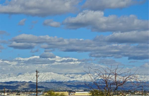 Beyond San Gorgonio would be Joshua Tree National Park.
The Tadpole and I went out on Saturday, first to visit my mom who's in the hospital recuperating from hip replacement surgery, and then secondly to pick up some caches. We did a circuitous route through Riverside and then north to Redlands and finally west through Rancho Cucamonga. We found a variety of caches, including one virtual cache which I ended up putting on my top 5% list. Our last three caches, I'd done some research on and we didn't have any coordinates for the three caches. We ended up finding all three of them without the benefit of the GPSr. The cache page descriptions and Google satellite images were enough.
With more rain forecast for this week, we'll have to hope that the weather cooperates on the weekend. Until then, we'll enjoy these respites between raindrops.
Picture was taken near Bravest of the Brave - by SlowMover

Tuesday, January 19, 2010
More Weather
The second of three storms blew through here today. We actually had blue sky this morning with some overcast, but the day became progressively colder and darker. It started raining hard just after noon. These pictures were taken around 4 in the afternoon after a half an inch of rain had fallen. We've received more rain since then and now the biggest storm is coming.


Monday, January 18, 2010
Inclement Weather
It's raining in Southern California. I have a weather station in my backyard with a minimum and maximum thermometer plus a rain gauge. So far, we've received a little more than 2 inches of rain from this first of three storms. There's been a respite since about 4 in the afternoon so we must be between storms at the moment. 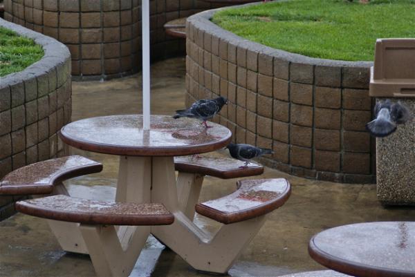 The third one is supposed to pack the biggest punch.
If you're reading this from the east, you're probably thinking that 2 inches isn't very much. Most of Southern California is desert to semi-desert. Where I live, we average 13 inches of rain per year. 2 inches in a 24 hour period is a lot of rain. The hillsides absorb a lot of it, but if there have been fires recently, then there will be problems with mudslides. The Tadpole and I went out to find some virtual flags today and we actually heard a broadcast from the emergency broadcast network this afternoon, warning about flash floods in certain areas. I think that's only the second time I have ever heard an actual emergency broadcast on radio or the television.
More to the point however is I used to think rain hindered my ability to find caches. I don't think that way anymore, although the rain did a number on us today, but I'll get to that later. With inclement weather, a geocacher just needs to have a different mindset. On the 30th of last month, Chaosmanor came out here to go on a hike with me. By the time he got over here, it was raining. Well, at least raining by Southern California standards, which is mostly a drizzle with occasional bouts of slightly heavier rain.
We could have gone out, but would have been hiking in mud which didn't sound like a whole lot of fun, so we opted to do some suburban caching. That was the best decision we did because we had a great time and found many caches that I'd passed up in the past due to high muggle activity. With the rain, muggles don't go out unless they actually have to and so most geocaches that tout on the cache page something along the line of "high muggle area" don't have that problem when it's raining.
This might not be much of a revelation to most, but I hadn't really thought that seriously about it.  My thoughts about rain was it made caching less fun. My glasses would get wet and I wouldn't be able to see as clearly. Clothes would get wet when you searched in bushes, etc. Chaosmanor and I have cached in the rain a couple of times, but that time last month, for whatever reason, was the eye opener for me. We found a lot of caches and enjoyed the time caching and the time together. As you can see from the pictures, places where caches might be hidden were quite vacant as opposed to what they might look like on a nice day.
Needless to say, I didn't hesitate to go out today, even though it was pouring. I figured that the rain would slacken at some point and we might be able to get a couple of caches in between the virtual flags we were seeking. We'd come to an agreement that if it wasn't really pouring, we might try for a cache here or there. The weather really didn't cooperate with us at all. It seemed like every time we got to a flag spot, it would be pouring, while when we were commuting between flags, it wasn't raining as hard. That's how it goes some days.
We did find a couple of caches near the end of our trek today. One was a lamppost hide in a parking lot. Rain kept the muggles away and we found it quickly. Another was by the side of a road. There weren't any joggers to bother us. I think the Tadpole and I both decided that we're not going to let a little weather deter us from our "appointed rounds."

Sunday, January 10, 2010
The Gorn and other spots
The second time 3blackcats and I went out to Vasquez Rocks Park, we hit much of the other side of the park. After completing the southwestern part of the park, we only have about 3 or four more caches inside the park that haven't been found.
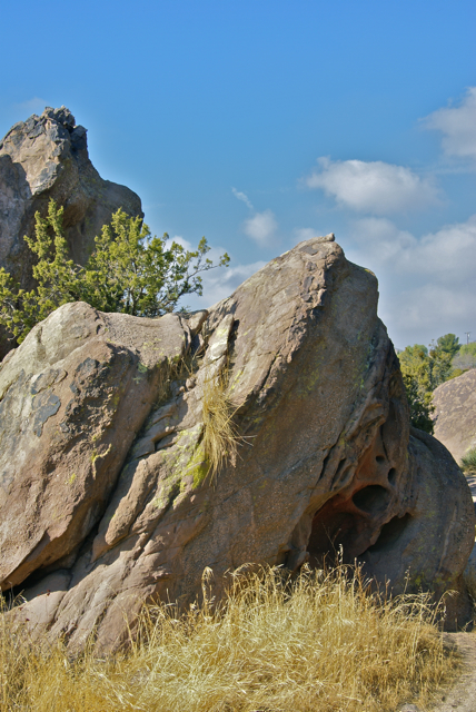 On the western edge of the park, there is a film ranch where film companies can come out to film outdoor type scenes. We also encountered a cache inside the park that had some filming connections.. The cache, entitled The Gorn's Lair, celebrated an episode of the television series Star Trek, where Captain Kirk is forced to fight the captain of another vessel. The other captain is simply called the Gorn.
The area around Vasquez Rocks was used as the outdoor setting for the fight sequences of the episode. Looking at some of the images on the web, it appears as if the principle filming was done near the main parking lot, about a mile away from where the cache was placed. I hadn't realized that the filming for this particular episode had happened here, but it does make sense that film companies would come out here to film outdoor episodes such as that one.
The area is probably not as quiet as it once was, due to the heavier traffic flow on the nearby freeway. But it still has a desolate look about it. I could picture R2D2 moving down a slope heading toward electrical short out by the Jawas in a scene that was actually filmed in Tunisia. I would be willing to bet that the freeway noise probably keeps many companies away today, although I'm sure there's enough filtering technology out there today, that it might not be as much of a problem as it might have been twenty years ago.
Living in Southern California like I do, it affords me plenty of opportunities to see spots that have been used in movies and television. I've visited the spot where the Lone Ranger used to rear up on his horse at the beginning or the end of this television show. The area where this famous rock formation is, now has condominiums surrounding it. You can still get a feel for what it was like back fifty years or so, but still, civilization has encroached around it.
Even in Central California, there are glimpses of other shows. Several times, I've visited the Monterey Bay Aquarium. This aquarium was used for several outside shots from Star Trek - the Voyage Home. 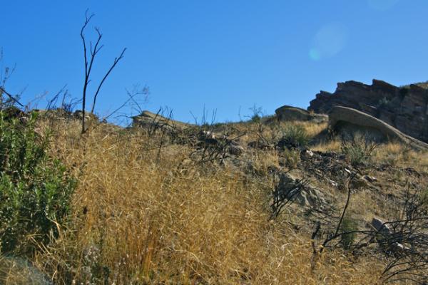 There is an area, open bay in real life that has been matte painted and blue screened into looking like a humpback whale enclosure, where Spock swims with the humpbacks and finds out that George and Gracie are expecting a "wee" one.
The LA Times posts areas where filming occurs on a regular basis. It's pretty common place here, so seeing a spot that's been featured in a film, or series or even a commercial can happen on a regular basis. In other areas, it's not as common, although my daughter has experienced it in Austria when she was there a couple of years ago. There is even a "Sound of Music" tour where tourists can visit spots in and around Salzburg, Austria where the movie was filmed. My daughter, although not part of any of those tours did enjoy spending time at the fountain where the Van Trapp family sang Do Re Mi.
Next time you're out caching and the area gives you that Déjà vu feeling, maybe it's because you really have seen it somewhere else.
Pictures were taken at or near the following geocaches:
Vasquez Rocks Earthcache - by supertbone
The Gorn's Lair - by EMC of Northridge, CA
