Recently, the question of how to switch between map sets on the Garmin GPSr was brought up. I posted a 'quick and dirty', three line instruction set but said I'd do a better writeup when I got home and had the time to take the screen shots. This morning, since I needed to load new maps into my 60Cx, I took the time.
Step 1: Load the maps into the GPSr.
1. Open Mapsource and choose which maps to start with. I chose City Navigator since that's what I usually look at.
2. Using the Map Select tool, outline the maps to send...but don't send yet, you have more to do.
3. Change the Map Set to Topo and repeat Step 2. This adds the Topo set to the already selected City set. One more to go.
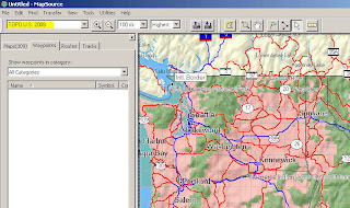
4. In my area, Moun10Bike has created a Map Set called NW Trails and I want those too. So I select that set and repeat again. This adds NW Trails to the other two.
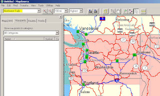
I now have three sets of maps ready to send. Connect the GPSr to the computer (if not already done) and click the 'Send to GPSr' button. Now go get some coffee, tea, or take a shower because it'll take a few minutes to load that data to the unit.
Step 2: Select the maps in the GPSr.
If I'm not mistaken, City Navigator will be the 'dominant' map set and be displayed unless turned off. This is so you can use auto-routing and search for specific things like restaurants, gas, cities, etc. So, to see the other maps it's just a matter of turning off the maps you don't want to see. Here is how you do that.
A. Navigate to the Map screen.
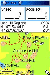
B. Press the Menu button on the GPSr and select Setup Map from the menu.
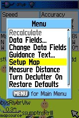
C. Select the 'Information' menu (it's the 'i' in the circle, second from the right) and press Menu again.
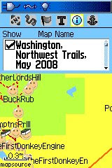
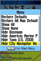
D. Scroll down and select 'Hide City Navigator".
E. You should now see the elevation lines from the Topo map set. Note that you can also see the dotted trail maps from the NW Trail map set too.
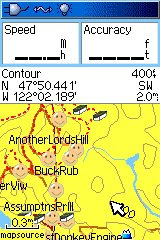 If I wanted to see just the Trails or just the Topo, I'd repeat steps B-D and turn off the other maps I didn't want to see.
That's it, you've now selected different maps to see for climbing a mountain or following a trail.
To see City again, repeat the steps only turn the map set on by selecting the "show" option instead. Don't forget to do this before trying to "route" again or it won't work correctly...do it once and you'll see.
Hopefully this information helps you get more out of your GPSr and gives you an idea of the mapping options available.

No comments:
Post a Comment