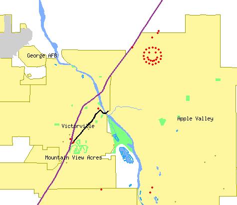
I created this map using the Tiger Mapping Services offered by the United States Census Bureau. It's a free service that allows  users to create their own maps. Usually, I just leave the map at a setting that allows me to see several of the western states and all of my cache finds and hides. For a look at that map, you can click here. I have a similar one for the virtual flags I've found. After looking at that map, I should probably zoom in on just California. I'll not be likely to find virtual flags outside of California for a couple of years.
There are all sorts of parameters that you can set with these maps. I like to see the county lines on the maps since I'm interested in finding a cache in every county of California and that allows me to see at a glance what counties I still need. I like the map because I can actually pick out various caching runs I've gone on with friends. The scale doesn't show the smiley cache run as more than a blob, so I zoomed in on it for this particular map.
If you look closely, you can see other red dots on the map. The two red dots in between Mountain View Acres and Victorville are two caches with ties to Route 66. The northern dot was found by the three of us last Saturday as we made our way over to the smiley caches. The southern dot is a virtual located at a very cool Route 66 museum that I wrote about previously.
As I'm writing this, I think perhaps I need to write a tutorial on how to make these maps. If you don't have too many cache finds, it's a relatively easy proposition to make one for yourself. I have the cache hides and finds map linked on my geocaching profile.
Wednesday, March 4, 2009
One last smile
Posted by
Paul Myers
at
5:11 PM
Labels: hike, Map, Ribbit, virtual flags
Subscribe to:
Post Comments (Atom)

No comments:
Post a Comment