I've always been fascinated with maps. I usually got to ride "shotgun" when we went on family trips. I was the navigator, which meant I got to follow our progress on the road atlas.  It also meant I could suggest routes of travel. Not all were taken, but it was fun to think about that road less traveled. In my travels, I've always enjoyed taking those kinds of roads, as they usually present a different perspective to what I've seen over and over again on other trips.
Such was the case over Veteran's Day weekend. Chaosmanor and I planned a trip up to Stockton. The two main routes north are either Interstate 5 or State Hwy 99. My usual route is to take the 99, because I find it slightly more scenic than the 5. More importantly, there seems to be natural breaks along the route, which helps gauge where you are on the trip. There are many towns along the 99 and I know I can usually make it to Bakersfield in around 2 hours, to Fresno in another 2 hours and then to Stockton in approximately another 2 hours.
The 5 is bereft of many cities and town and the scenery is pretty much the same with the exception of the cattle stockyards near Coalinga. Other than that, there's no way to really tell where you are or how long you have to go until you've reached your destination. If you're in a hurry, the 5 is the way to go because it's about a half an hour shorter than the 99. But the main purpose of this trip was to take the scenic route - well scenic in regard to geocaching.
Outside of the geocaches in the major cities along the 99, I've pretty much cleared out most caches along that route. So Chaosmanor suggested we take the less traveled road, parallel to the 99. It would still take us north, but we would avoid most of the larger cities, while driving through open country, which is where you can usually find large numbers of caches without the worry of caches being muggled, or having to worry about crowded situations.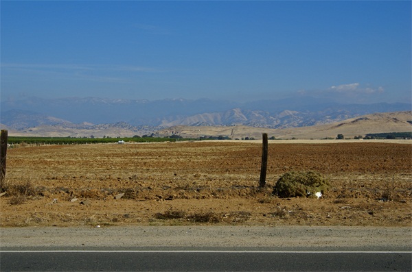
As we made our way north, I saw one of the caches that Chaosmanor had added to his route. Many caches like this I've found in the past usually are mystery caches, not actually near the geographic coordinates that are posted on the cache page. This one, however, was a regular with coordinates N 36˚ W 119˚. This would be a degree confluence, one of many points on the earth where a line of latitude and longitude intersect.
According to the Degree Confluence Project, you are within 49 miles of a degree confluence anywhere you happen to be. Just because you're close, doesn't mean that you can necessarily access these points, however. If you think about it, you'll realize that 70% of the degree confluences fall in water and are difficult to access. Many more fall on rough terrain. Although a map is flat, the world isn't and we have to take into account the lay of the land. But there are some, like the one we visited, that are very easy to access.
The confluence point was literally by the side of a road. To the west, was a large orange grove. To the south and north, the road traveled onward. To the east, the view was of foothills and in the distance, the Great Western Divide which makes up that portion of the Sierra Nevada. There was a slight dusting of snow on top of the mountains. I'm sure there's a lot more snow up there now as we've had several winter storms come through California in the past week.
 For a map nut like myself, this was kind of cool to visit. You see all of those lines on a map, yet often don't really think that much about why they're there. These imaginary lines are the basis of GPS technology. They tell us where we are and because of mathematical formulas, GPS receivers can take electronic signals from satellites in outer space and also tell us where we are, with a great degree of accuracy. Most receivers are usually good to within 30 feet of accuracy. And that's where the fun comes in with geocaching. The receivers get you close, but then you have to do the rest.
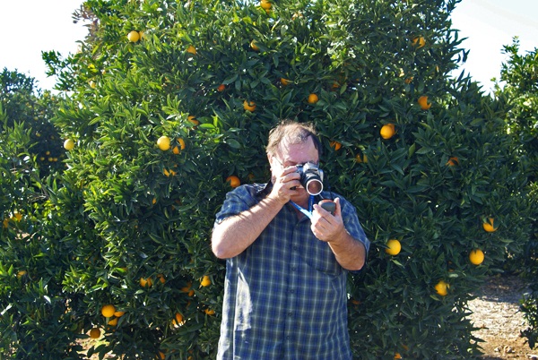
According to my GPS receiver, I was within 7 feet of the confluence, based upon the accuracy of my unit at the time I took that picture. You can also see that each of our receivers didn't agree, as I later took a picture of Chaosmanor attempting to zero his receiver out. He was standing about 15 feet away from me while I was at my ground zero point.
After I found the cache, which was hidden nearby, I discovered that my receiver had decided to creep a little bit to the west, closer to my friend's point of confluence. This isn't uncommon. When we go out caching, our units very rarely agree on a particular point, but usually get us close. For $200, I'll not quibble about slight inaccurate readings I received that day. The point is, I was the closest I've ever been to a degree confluence with fairly accurate readings. And from a geek standpoint, it really is kind of cool to see all those zeroes show up on your GPS screen.
Pictures were taken at or near the following geocache:
Confluence N36 00.000 and W119 00.000 - by TheeSugaBear
Wednesday, November 24, 2010
Degree Confluence

![]()
![]()
Subscribe to:
Post Comments (Atom)
No comments:
Post a Comment