In November, Los Angeles gets treated to the annual U.C.L.A./U.S.C. football game. An old saying I've heard in the past was, "On a clear day, U.C.L.A. . . . . . . . . on any other day, U.S.C. Obviously, this one was created by a Trojan fan, but if this past week is any indication, U.S.C. might be in trouble this year. 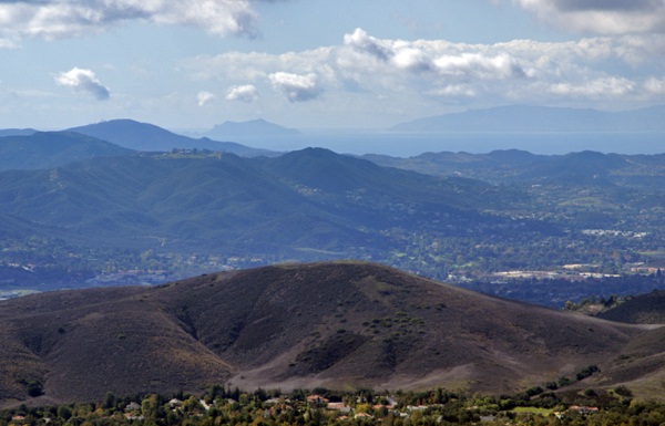 But this entry is not about college football.
Last Saturday, I went on a hike with my friend Chaosmanor in the Agoura Hills area of the Los Angeles Basin. We'd planned a trip to get us several geocaches, plus a virtual flag that would score me the maximum number of points in the game. We found several caches before heading up to the trailhead to begin our hike.
The first part of the hike was on a new trail open for about a year or so. Surprisingly, it had no caches on the trail, so Chaosmanor took it upon himself to hide a couple while on our way. Soon after those hides, we were on a fire road heading up to some caches that hadn't been found in exactly a year. Well, they still haven't been found. One cache we started to attempt, but didn't finish, mainly because the terrain had changed slightly in the past year. There was a lot of plant growth, which concealed the main way up to the cache and any other route that we could see, looked extremely treacherous and so we passed on it.
The second cache was similar, so we didn't even make an attempt to get up to it. The third cache was attempted after a nice lunch at the end of the fire road on which we'd hiked. This one was probably the most frustrating of the three since we were able to hike up to the cache site and do a very thorough search of the area. After calling a lifeline, we were pretty much able to verify where the cache probably had been, but we couldn't find the ammo can that had been placed there. 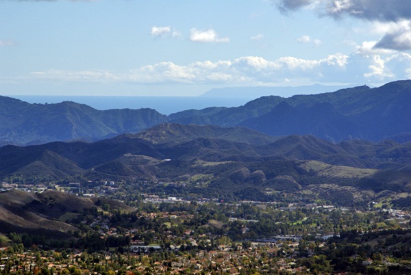 We did find, what appeared to be two Asian memoriasl, complete with pictures in nearby alcoves. The only thing we could possibly think that could have happened was that whoever put those pictures up there, took the cache for some reason.
After striking out there, we headed further up along a game trail and found another more established trail that took us up to the virtual flag and a couple of other caches, including a virtual cache at the top of Simi Peak, just inside the Santa Monica Mountains National Recreation Area. This stop was probably the highlight of the day.
The peak is only 2403 above sea level. I was able to verify that with a laminated sheet at the peak. I put my GPSr down next to the sheet and eventually, it also read the same elevation above sea level. Just after I took the picture, the elevation on my GPSr changed again. I've noticed that on other occasions as well, so I'm not ready to say that my GPSr has great accuracy when it comes to elevation, just that I was able to get the two numbers to coincide.
That didn't make the highlight reel though. What made this spot truly noteworthy was the view. Even though we were at fairly low altitude, we had a complete 360˚ view which stretched for miles and miles, literally. Originally, I had been looking to the west from the peak. Chaosmanor had already pointed out the ocean from further down, but once we got on top of the peak, we spotted Anacapa Island and behind it, Santa Cruz Island, both within Channel Islands National Park. Looking at the map, it looks like we were at least 30 miles, probably more distant from those two islands.
Then we got a bigger shock, I believe, when we looked south and could see the ocean and Catalina Island in the distance. 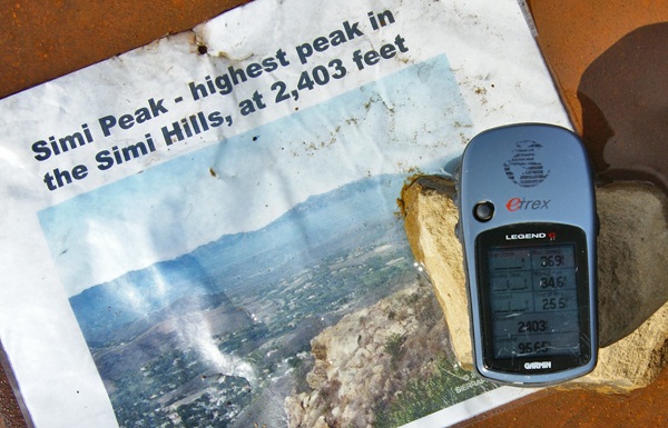 Catalina Island 26 miles from the mainland, while Anacapa and Santa Cruz are closer to the mainland. It's become a rather rare occurrence when one can see Catalina Island. It's usually obscured by haze, smog and fog, usually a combination of all three. It definitely was a treat to see it so clearly in the distance that day.
The weather conditions were just right that day where we were. Other hikers might not be so fortunate, but hopefully, that won't stop them from coming up there. I can imagine that peak in fog. That would give an entirely different perspective to the area, that's for sure. We spent a great deal of time up there, getting the necessary information to fulfill the requirements, take pictures of the scenery, take pictures of the benchmark that's also at the top and also just to enjoy the view. It's not often that the Los Angeles area is that clear. Besides the ocean views, we also had amazing views of Simi Valley to the north and the San Fernando Valley to the east. It was a picture perfect day.
Eventually, we knew we'd have to descend back into civilization and we did it reluctantly. We hiked down the trail heading to other geocaches further down the slopes of Simi Peak. At one point we missed a trail junction and ended up further north than we had originally anticipated being, so that added another mile or so to our overall hike, but it was definitely worth the effort. It had been a good climb up and a good hike totally just over 8 miles. It had been a good day.
Pictures were taken at or near the following geocache:
Simi Peak Returns - by WM6P
Friday, November 5, 2010
On a clear day...

![]()
![]()
Subscribe to:
Post Comments (Atom)
1 comment:
That was one of the best geocaching hikes I've ever been on, pure, plain and simple. Really glad we did it, even if we didn't get all of the caches we tried for.
Post a Comment