Sunday, October 18, 2009

GPS Accuracy


Yesterday I was able to get out and hike.  There's a new preserve in the north part of Etiwanda with hiking trails in it and I wanted to see what it was like.  Last weekend would have been a better weekend to go because of the weather, but I was busy then.  We had rain earlier in the week, but it's been in the 90s the past couple of days.  Since the Tadpole was just going as a spectator to his cross country meet this weekend, it was the perfect opportunity to get out and cache.

I took him to school to catch his bus, then came back home, loaded up the GPSr, grabbed the gear that I needed and drove the 15 miles over to this preserve.  In the link I provided, the pictures show at least 4, possibly five, cache sites that I visited yesterday.  I found 12 caches yesterday and DNFed 5 others, of which I'm relatively sure that 4 of them are there.  I just didn't do a good enough job of scouring the area to get the cache.


The preserve's main loop trail is 3.25 miles in length and has mile post markers every quarter of a mile.  Each of these markers also have elevation listed on them.  Now I know that GPS accuracy can vary greatly depending upon where you happen to be, but this marker was out in the open without any kind of tree cover or interference, so I figured I'd get pretty good readings and as you can see I did.

Since I posted several DNFs out there yesterday, I expect to be back in that park again.  There were other spots to hide caches on the trail.  Had I known a little bit more about this park, I might have been tempted to bring a cache with me to hide.  I might still do that since I found several nice spots along the trail where a cache would probably do well.

Pictures were taken at or near the following geocache:
NEP #12 - by the4dirtydogs

Profile for Webfoot

Monday, October 12, 2009

Archiving Caches

Yesterday, the Tadpole and I hiked into the Claremont Wilderness Park, which is located in the foothills north of our house.  Most of the caches we've hidden are in and around this park, which has a nice five mile loop trail through the heart of the park.  The fall, winter and spring are definitely the best times to explore this park and all of its side trails.  Being situated in Southern California, the vegetation is somewhat sparse and there isn't much shade on the upper elevations of the trail, so it's a very hot walk in the summertime.  It's getting pleasant right about now in the park.

Our main purpose for heading up into the park was one of my caches, Scenic Value.  I hid Scenic Value on New Year's Day 2007, so it's been around for almost three years.  I'd gotten a couple of DNFs on the cache, but that wasn't unusual as it was hidden deep in a scrub oak tree and difficult to find.  I'd even had a hard time finding it once when I went up to check on it another time.  I wasn't too concerned when the first DNF showed up mainly because it was a new cacher and I figured it just might have been overlooked.  When an experienced cacher later also DNFed the cache, it was time to check it out.

I was actually surprised when the Tadpole and I got up there and couldn't find it.  I'd brought another cache just in case, but after getting to the site, decided against replacing it.  There was a lot of evidence of erosion and the starts of a bushwhacking type of trail leading up from the canyon below.  One of the finds on the cacher had even mentioned about coming up that way.  That was not something that I really wanted to promote, so I decided to archive the cache.

Just down the trail from Scenic Value is a small spur trail that would be a nice spot to hide another cache.  There had been a cache there previously but it had been burned out and either washed away or buried during a subsequent rainstorm.  The area has recovered nicely following the fire and could have a cache placed back in that side canyon.  I'll have to check that out in the near future and decide whether another cache in that general vicinity would be a good idea.

If not, then I'll leave the area alone.  Not many other cachers hide up there, so it will probably stay cache free for the foreseeable future.  That might not be such a bad thing.  It'll end up just being a nice open area along the trail in between other caches.

Pictures were taken at or near the following geocaches in the Claremont Wilderness Park:
Where is the parking lot? - by Mazingerzz
Scenic Value - by Webfoot

Profile for Webfoot

Saturday, October 10, 2009

Southern California Rarity

When you cache in Southern California, you get used to see things a certain way and when things end up differently, you sometimes do a double take.  At the minimum, you stare and try to make some sense of what your seeing.

This was the case when I dropped my son off at Santa Cruz last month.  I ended up traveling south along the 101 through the Salinas Valley.  Driving on the freeway doesn't afford you much time to really look at the scenery and because of its location, you really can't see down into the valley very well either.  However, when I ended up on a side road looking for a couple of caches, I noticed the Salinas River, flowing with water.

Looking at a map, this one is fed by coastal mountain streams, which in late September would be very dry as the rainy season has been pretty much done since mid-March.  Lake Nacimento reservoir also feeds this river, so either the powers that be had an abundance of excess water, or they were letting water go in anticipation of the upcoming wet season a few months down the road.  Either way, it made for a very pretty pastoral picture of the Salinas Valley.

Picture was taken at or near the following geocache:
Binary Blues - Black Gold - by Just a Short Walk

Profile for Webfoot

Thursday, October 8, 2009

Travel Bug Pictures

A year and a half ago, I made a confession that I haven't been very good about maintaining even to this day.  I feel I've done a much better job about taking pictures of the different travel bugs that I've had in my possession, but I'm still not at 100%.  At this point, I'm not sure that's possible.  In my opinion, some travelers don't lend themselves well to photographs.  I think this is especially true with geocoins.  Geocoins area small and difficult to get into focus with the other aspects of an area that the coin is going to be placed.

Many travel bugs are the same way, however, I've found some larger ones are much easier to photograph than others.  I found Arthur up in the high desert this summer and took him up to Santa Cruz with me last month.  I got a good picture of him holding another travel bug when I first found him in the desert and also got a nice photo of him standing in the leaves of the World's Largest Artichoke.

I'd seen this particular virtual on our drive up, so I made it a point to stop on the way down. I got there too early in the morning to partake in some of the nearby restaurant's finer artichoke cuisine, but I was able to stop at a local farmer's market and buy some artichokes to bring home.  10 for a dollar was a bargain price, even for some on the small side.  I think back now and I should have purchased 20 at that price.  Although I suspect the season will be over by the time I get up to Santa Cruz again, probably in late November, but if they have them available then, I'll buy some more.

Getting back to travel bugs.  During that desert run, I also took, what I thought, was a rather whimsical picture of the R2D2 travel bug that I found near Point Reyes National Seashore in July.  The spot where we found a nice travel bug hotel had some rock formations similar to what one might find on the fictional planet of Tatooine in the STAR WARS movies.  Those kinds of pictures are the kind that trigger musical responses in my head.  When I look at that picture, I can hear John Williams theme of the robots walking through the desert on their way to capture by the Jawas.

At the moment, I have three travel bugs sitting on my desk.  I have a geocoin in the shape of a head of lettuce.  "Lettuce go caching."  There's also a Triceratops and a bison tube that I thought was a traveling cache when I first picked it up, since it had a log sheet in it. It's particular goal is to travel to different countries and have the person who placed it in a cache write the name of the country on the log sheet inside.  I'm not sure where this one is going to end up, cache-wise, but at least it's closer to another country here than where it used to be farther north along the 101.

Pictures were taken at or near the following geocaches:
The World's Largest Artichoke - by ynots4
Mojave Green Travel Bug Motel - by The Dananator

Profile for Webfoot

Monday, September 28, 2009

Reset more than once

After taking my son up to Santa Cruz for his first quarter at college I had an entire day to leisurely drive home. I took the 101 south to Paso Robles, then took the 46 east over to the Central Valley. For those of you who are film buffs, or know the history of this road, the 46 is the road that the actor James Dean died on, back in September of 1955. Excess speed and a car turning left in front of him proved to be his undoing. There are monuments along the road dedicated to James Dean and I found a cache that day entitled James Dean's Last Ride.

At a spot just off the 46, I found a bridge that a cache was hidden near.  At first I thought the cache was going to be attached to the bridge, but after surveying the bridge, I realized that it was probably down below in the stream bed.  It was very hot that day and it was getting toward noon and I figured that with my low blood sugar and the fact that I was alone on this trip now, it probably wouldn't be prudent to expend much energy getting down to the cache and then climbing back up the embankment.  I suspect I'll be driving that route many times over the next couple of years, so I'm pretty sure I'll have other chances to get that particular cache.

I did notice a very nice benchmark on the bridge.  At first glance, I didn't expect it to be in the geocaching benchmark system since the benchmark was dated 1978.  I was even more convinced that this one wouldn't be in the system since the cache page for the cache under the bridge stated that the bridge had been washed out in 1996.


And yet, when I got home, I looked it up and found the benchmark in the system.  They reset the benchmark, hence the name of the benchmark.  Curiously, it appears as if this particular bridge has been washed out more than once since the description from 1978 states that it was reset in a newly constructed bridge and the owner of the nearby cache states the bridge was washed out again in 1996.  If all this were true, then this benchmark really does deserve the name of reset.  Either way, it's fun to reconstruct some of the history of the local area based upon finds like this.

Pictures were taken at or near the benchmark C617 Reset.

Profile for Webfoot

Friday, September 18, 2009

Off to college

My middle child will be attending UC Santa Cruz this year. This weekend, I'll be driving him up and helping him move into his dorm. Then on Sunday, I'll come home alone. That's two at college and one in high school. Where did the time go?

I plan to do a little geocaching and probably some GeoVexilla flag capturing as well. I might drive down the coast through Big Sur and get that Alphabet Soup challenge cache. If the weather is good, it might be a really good time to go.

Sunday, September 13, 2009

Electrifying

Chaosmanor and I stumbled across Night Caching: The Tesla Experiment, while out caching back in August.  One of our local cachers, Losel2 made this particular cache his 4000th find about a week before we ended out in the same area.  

Unfortunately, I wasn't able to go with him when he made his milestone grab and so didn't get the full effect of this really intriguing cache.  Chaosmanor and I went during the day, got the gist of the cache, but didn't get the full effect.

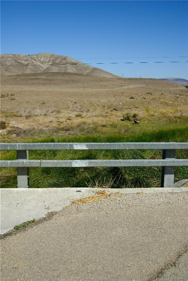
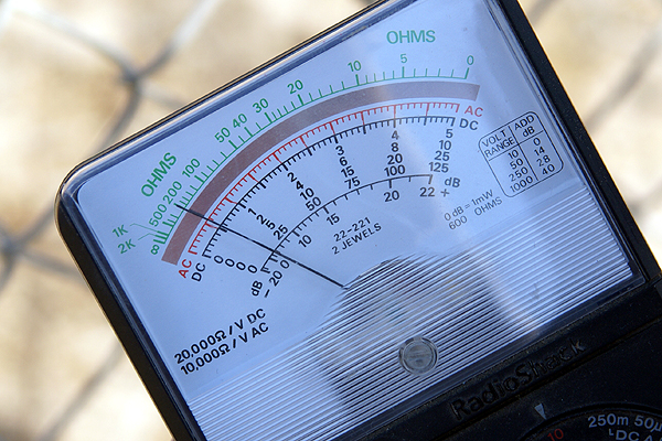
In short, Nichola Tesla theorized that electricity could be conducted through the air and went about creating experiments to prove this.  This cache is placed under high tension wires in an effort to help the cache finder recreate a couple of Tesla's experiments.  We took a voltmeter and conducted our experiment, getting a slightly  higher reading for it after we touched the fence with the volt meter.   Using the voltmeter probably wasn't necessary, as all you had to do was touch the fence and you'd get a mild shock from the excess electricity coming from the wires to the chain link fence.  As you can see from one picture, the electrical wires hang fairly close to the ground.

When the gang that accompanied Losel2 on his 4000th came, they came at night, which was probably the better way to go about it. After coming home and logging the cache from our daytime excursion, I looked at some of the pictures in the gallery.  Impressive is one of the words I'd use.  Fluorescent light bulbs lighting up just by touching the fence are standard pictures there.

The one thing I've learned about geocaching is to always expect the unexpected.  Local cachers know their area best and show off the unique aspects of their area in creative ways.  Well thought out caches that take you to interesting areas you probably wouldn't even think twice about on normal days if you didn't understand geocaching help with the enjoyment of this hobby.  Had I not been a geocacher, I never would have stopped here.  It was a fence next to a dirt road.  There's lots of them out here in the desert.  But add an electrical field into the picture and you have science in action which makes for a learning experience.  Something like that makes my top 5% list every time.

Pictures were taken at or near the following geocache:
Night Caching: The Tesla Experiment - by KG6EAR & co-maintained by WindyMatters!

Profile for Webfoot

Tuesday, September 8, 2009

Challenges

In the past, I've written about the 58 California County Challenge.  This past weekend, Chaosmanor and I worked on two other challenge caches that we'd like to accomplish sometime in the near future.  The first is called Alphabet Soup.  It's a relatively easy challenge.  Find a cache beginning with each letter of the alphabet.  When Chaosmanor showed it to me, I figured, hey, not a problem.  And it really wasn't.  I read a little more closely and found out the caches had to be found after the date of publication for Alphabet Soup, July 30, 2008.

So I went back and checked and discovered I only needed an X cache.  Not bad I thought.  Chaosmanor came out the next weekend and we found a local cache near me beginning with the letter X and figured we were done with it.  The cache is up on the central coast of California between my house and where my son will be attending school.  A trip down Hwy 1 and I could get the cache.  When I was logging that last X cache, I discovered one flaw in my theory that I was done.  All the caches for the alphabet had to be placed before publication date.  This latest X cache had been placed in 2009 so it didn't count.  Fast forward to this weekend, and we found a cache down in Orange County beginning with the letter X.  Now, I'm ready to get Alphabet Soup.

The other challenge is a little more daunting.  Find a cache in each USGS quadrangle in Los Angeles County.  When we first decided to go for this one, I had almost half.  I got three more quads off of my map this weekend, El Monte, San Pedro and Long Beach.  All three of which I've already found caches in, but they didn't count because once again, they had been found before publication date for that particular challenge.  All of the rest of the quadrangles that I need are to the north of me in the mountains and deserts of Los Angeles County, much of which is on fire right now, so we'll see.  I had plans on making this one my 3000th find.  We'll see if that pans out or not.

The 58 county challenge cache I didn't work on this past weekend, but did work on while on our trip this summer.  Since I needed virtually all of the Northern California Counties, any finds up there would be gold for this challenge.  Ten counties later, I'm just 16 counties short of making the requirements for that challenge.  Next summer, the planned trip is up the eastern side of California to Lassen National Park and then south through the central valley to get the rest of the missing counties.  There is a GPS maze exhibit planned in Redding, CA for next summer, so that's also high on our priority list to see as well.  These next few months should be enjoyable from a caching standpoint.

Profile for Webfoot