Last Saturday dawned amazingly brilliant which was fortunate because the Tadpole and I had plans to head out to the desert for some geocaching. 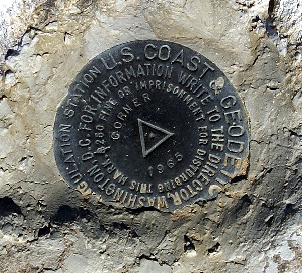 I loaded a bookmark PQ into the GPSr, and after a couple of side trips in town to get a couple of those elusive caches we hadn't found yet around here, we were off. The trip out was rather uneventful, taking about an hour, maybe an hour and a half with a couple of caching stops for us to get up to Joshua Tree, CA, which is amazingly located just north of Joshua Tree National Park.
We continued up Old Woman Springs Road which runs in a northwesterly and then westerly direction up to Victorville, CA. This road runs nearly over the epicenter of the June 1992, 7.4 Landers earthquake. I'd been out to this site a couple of times, even stood at the epicenter looking at a 6 foot high escarpment that hadn't been there before the earthquake. At a cache looking down a road that crossed the major fault that ruptured, 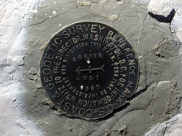 we were able to see the telephone poles, aligned up, then misaligned as they crossed the fault line in the distance. The Tadpole thought that was really neat. I just marveled, once again, at the power of Mother Nature.
Continuing our drive west, we stopped at a geocache alongside the road and were awarded with an unexpected bonus....Benchmarks! The Tadpole had gotten out of the car and walked closer to the cache site and I hear him exclaim, "Whoa Dad! There are a couple of benchmarks out here." Sure enough, we found several nice disks embedded into the rock. Then we round another disk and another and another. Eventually, we counted five disks, which led to three or four benchmarks, depending upon 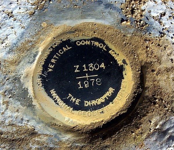 how they are counted. All the benchmarks were within 50 feet of one another. It was a major convergence of benchmarks.
Needless to say, I had to go back to the car to take pictures. It was then, after getting the camera that I looked at my PDA for the cache listing and realized that I should have already know about these benchmarks, since the name of the cache were were trying to find was called, 5 Benchmarks TB Hotel. Well, Doh!
I first wrote about benchmarks back in January when this blog was relatively new. Since learning about geocaching, I've logged 19 benchmarks, of which 14 have been logged since last June. I'm not sure what to make of this. Either I've become more aware of benchmarks, or I'm getting out on the trail more in this past year, which will get me out to spots where benchmarks tend to be more prevalent. 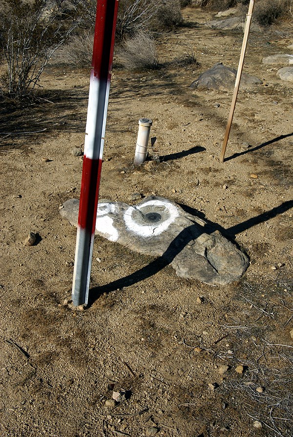 Either way, as I've noted before, it's a nice little diversion.
When all the pictures of the different disks had been taken, we eventually looked for the cache. The tadpole has taken a new leap in his cache finding ability and was the one who found this cache. He beat me to quite a few caches this day, but I think this one was the hardest find, where he just out hustled me, getting into the nooks and crannies of the rocks to finally scope it out. He was very proud of himself.
When I said there were three or four benchmarks, depending upon how you counted I wasn't kidding either. The cache is called 5 Benchmarks, because there are five embedded disks located in the general area. One disk has two reference points, both other disks that actually point to the benchmark. These would be the ones that are labeled Corner on them. Then there was a two foot tall metal pipe with a benchmark on the top of that one, plus one other one with so many identifying letters and numbers it was difficult to keep them all straight.
Interestingly, this particular benchmark is actually listed twice in the benchmark system, labeled as two different benchmarks, yet they both identify the same benchmark. 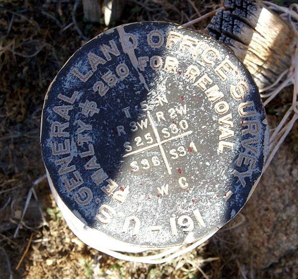 I don't have any explanation for this, as why this is the way it is. All of the disks, whether they be three or four separate marks were an added bonus to our trip. In fact, we overlooked a couple of other benchmarks along the way which were clearly noted on the cache pages. I guess I need to look at the cache pages in my PDA more often.
Pictures were taken at or near the following geocache:
5 Benchmarks TB Hotel - by Team Christiansen
Tuesday, December 9, 2008
Benchmark Bonanza

![]()
![]()
Subscribe to:
Post Comments (Atom)
3 comments:
I used to head out that way once in a while when I was stationed in 29 Palms. Has the area recovered from the recent fire?
Great story on these BMs, Paul :-) As you know, I've been fascinated with benchmarks for many years, since long before geocaching. I've got 185 logged on GC, and have nearly 100 Recoveries logged with the NGS, plus a few dozen that I've not logged yet on either site. I tend to look for the things on longer caching and dashing trips, if time permits. Wish I'd had time for some yesterday, but early sunsets don't allow for as much of that sort of thing, not when one drives 400 miles.
Anyway, I loved the variety of the Marks you photographed. The last one, from the General Land Office, marks where four 160-acre sections meet. Sharon and I found one of these up in the Sierra a few years ago, and another on the Deal Trail, in the Los Padres National Forest, after the Zaca Fire Burn Area was re-opened. I've never seen any of them in the NGS lists, as I don't think they have either the accuracy of position, or of elevation, required for Geodetic Survey work. They serve an entirely different purpose; neat that one of them was right near the others. But you can imagine my surprise to find that not only is this one listed with the NGS, they had it in the system twice :-o EV1638 has since been Archived by the NGS, but GC can't delete it from their system without screwing up the folks who have logged it. Gives me more reason to be sure to note *every* BM I run across; one never knows...
As for the others, you have a Triangulation Station, with at least two Reference Marks (this is the "Corner" Station"), and a Vertical Control Station: Z 1034.
The former Station is one of many that served for decades as the foundation of surveying; it was from these that the vast majority of surveying of land boundaries, road and rail construction, etc. was done. The RMs were laid so that the Station could be found if minor conditions changed: bushes and shrubs, small rock and dirt falls, etc. These Stations usually were amongst the most-accurately known in both position and elevation.
The later is a Mark which elevation had been determined with as much accuracy as possible. Vertical Control stations are much more common, for several reasons, which I won't go into here, than are Horizontal Control Stations. It would not surprise me at all if this one, and several others in the area, were laid down to monitor changes along the Landers Fault, as well as to compare changes between it, the Mission Creek Fault, the San Andreas Fault and the many other fault lines that are influenced by the North American and Pacific plate boundary. It probably was one of many that was carefully scrutinized after the Landers Event. You might find it interesting that the Girl Scouts filed a Recovery on it this past Spring :-)
As for why you've gotten so many more in the past year or so, compared to previously, that's what you get for all those caching trips you and I have taken ;-) We have found at least five BMs on those trips, mostly ones that I was intentionally looking for, but one that was purely serendipitous.
BTW: Team Christiansen looks to have done a lot of work on the BMs in that area, and they seem to know what they are doing, even more than I do. Perhaps there is a surveyor on the team. Nice to see cachers get involved with these things. The NGS is dreadfully understaffed, and it relies on local surveyors, and interested civilians of all types, to help them Recover these Stations. It isn't hard to do, it can be a lot of fun, and it serves a Real World purpose. Many of them are not very useful in any practical sense, but as historical "documents", they help tell the story of the Great American Westward Expansion. It's nice to be a small part of that :-)
Just John
We didn't notice any kind of fire damage in the area, so I guess the answer were be yes.
Post a Comment