This is not what most of you probably think it's about. When I first heard about locationless caches, it was in February 2002,  less than a year after I started caching. It was an intriguing concept; find a thing that matches a particular criteria, take a picture with your GPSr, note the coordinates and then post the log with those coordinates and the pictures. Usually, locationless caches had to be unique, so people couldn't log the same thing over and over again. Once someone logged Yosemite Fall in the Beauty of Waterfalls locationless cache, then no one else could log that particular waterfall. Other waterfalls could still be logged, so the longer the caches hung around, the more interesting some of the logs and pictures tended to be because the less famous, yet still beautiful waterfalls started appearing on the cache page.
There were several things that I liked about locationless caches. I may be wrong, but I think you had to have a picture taken at your locationless find in order to get credit for the cache. I liked that, since there was no log book to prove you'd actually 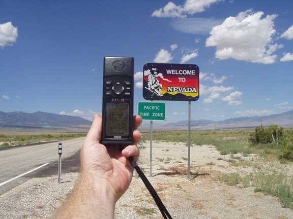 found what you were looking for, but there was at least visual evidence. The second reason I liked them was it made me more aware of the environment around me.
Probably the most famous of the locationless caches was Yellow Jeep Fever, where you had to get a picture of your GPSr with a yellow jeep. Sound easy? Not really. I can remember right after I discovered locationless caches, I was driving up to Lake Arrowhead and I passed a yellow jeep going the other way on the road. It was very frustrating to see something that you could log, yet not be able to for safety reasons. I actually saw another jeep, possibly the same one, when I was heading back down the road later that same day. I eventually found a yellow jeep in a parking lot in Upland, CA while I was out doing some other caching. I'd stopped to find a cache, looked over, and there was a nice jeep with Colorado license plates parked rigth there.
There were so many locationless caches during their heyday, that it was virtually impossible to keep track of all of them. 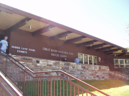 I kept a running total in the back of my head of about 20 locationless caches that I found the most interesting. I figured that was about the most I could keep track of at one time without writing them all down. Once I would find one of them, then I'd substitute another one from the main list, so the list was ever changing. I liked the little challenge associated with finding them. I'd see an American flag, take the picture, get the coordinates and then go home and attempt a log. Many times, it wouldn't happen because that particular American Flag, or waterfall had already been logged. So it was important to have back up plans as well.
Every time we'd I would make sure we'd find a couple of the locationless caches. Some are very easy, like an American Flag. Since we would always camp in national parks, it would be fairly easy to get one of the American Flags at the park headquarters or visitors center. That same trip, I also wanted to get a park headquarters locationless too, but 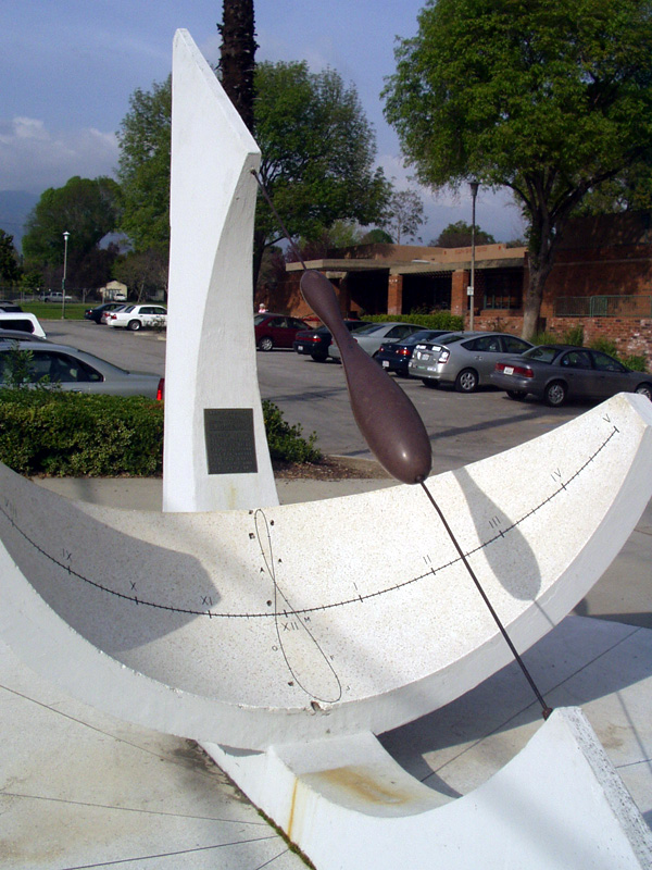 I didn't want to do the same area for both flag and headquarters. I wanted a little bit of a challenge.
That particular year we were going to be camping at Cedar Breaks National Monument in Utah and Great Basin National Park in Nevada. I figured I'd be able to get an American Flag at one park and the park headquarters at the other park. I ended up getting the national flag before we got to either park. We'd stopped for gas in Mesquite, NV, right on the border of Nevada and Arizona along I-15. Across the street from the gas station is the Oasis Hotel and Casino. Flying out in front of the casino is the largest American flag I've ever seen, so I decided to waypoint it and take a picture of it just in case. When we got home, I discovered the flag hadn't been logged as a locationless cache yet, so I decided to log it.
Locationless caches were all archived in January 2006 and have been moved over to the Waymarking site that Geocaching.com also maintains. It's basically the same thing and yet it's not. Keeping track of locationless caches on Geocaching.com was easier for me at least. I know there are some people that have embraced Waymarking. I can take it or leave it at this point. I am an officer in the Water Tower group at Waymarking, but I haven't marked a water tower in quite some time.  The thing about Waymarking that is good is the fact that you don't have to stop in a particular category after you found one. Just because I've already found a water tower, doesn't mean I have to stop looking for other water towers. With locationless caches, it was "One and Done" with a particular category. If I wanted to find more Presidential statues, I could, but I couldn't log them anywhere. So, I guess in that sense, Waymarking has taken care of that aspect of the game.
When they were around, I found 25 locationless caches. Of those 25, I think I'd still try to find 24 of them again if I could. Ironically, the one that I wouldn't find again, was the one that got me started with them. It was called Where's in a Name? and it involved getting help from someone on the other side of the world to help you log the cache. I wasn't at a particular point to take a picture and get credit for the cache. But it did get me interested in the overall pr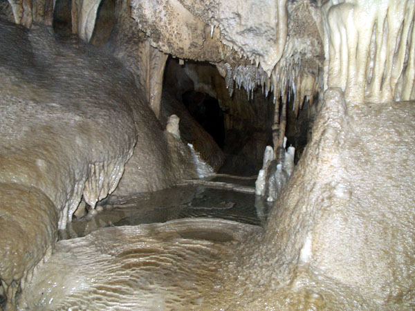 ocess and got me to look around me a little more closely as I was out and about. You never knew when you were going to run across an astronomical observatory or a Rails to Trails that you could log.
And yet, as the locationless helped me become a little more observant about what was around me, it also didn't for some reason. I know that doesn't make sense, but when I logged the observatory locationless, there was a virtual cache at the same location. For some reason, I wasn't aware of this virtual until a couple of years later when I got back up to the same area and logged the virtual. To this day, I'm not sure why I didn't log the virtual at the same time.
Pictures were taken for logging the following locationless caches:
Yellow Jeep Fever - by Team CBX2
Make a Break for the Border - by The Dam Trolls
NPS HQ - by MartyFouts, Adopted by bullit
Sundials - by outforthehunt
Observatory Quest - by Anton
Speleo - by Melak
Saturday, December 27, 2008
Environmental Awareness

![]()
![]()
Subscribe to:
Post Comments (Atom)
3 comments:
I'd be more into waymarking if the site were reliable. It's so slow and tends to time out on you.
More users of the site would also make me more interested.
It seems like waymarking is missing 'something' to pull people in, but i'm not sure what. If groundspeak can figure that out then i think it would take off. If groundspeak doesn't, i suspect another organization will.
Maybe a facebook app?
I think the appeal to the locationless was that you got a smiley out of it. People will claim that it's not about the numbers or anything like that, but basically, we like to have something that celebrates our successes.
Look at Ohio St. Grown, albeit young, men compete on the gridiron for stickers on the sides of their helmets. Geocachers do the same thing for little yellow smileys, whether it's a competition or not. With Waymarking, there's no real smiley to gather up.
Then again, it could be something else entirely.
I logged a locationless yesterday. It wasn't for the smiley, it wasn't for the points. It was to click one more off in my database.
Locationless (or as I refer to them, The Neverending Scavenger Hunt) caches still exist at terracaching.com. The game has morphed a bit. Here's a list of them.
You mentioned the US Flag hunt. I listed one called that too . . . except it was a bit more difficult than the original. The flag had to be flown improperly according to US Code.
Post a Comment