As noted in my last post, a straight line is not always the shortest distance between two points. That could not be more apparent than the route we took to get from Lassen Volcanic National Park up to Lava Beds National Monument.
 Although the monument is almost exactly due north from Lassen, the route to get there takes you northwest, then northeast, then northwest again. That's just the way the roads go up there. Finally, there's that little decision about which entrance to take, the north or the south?
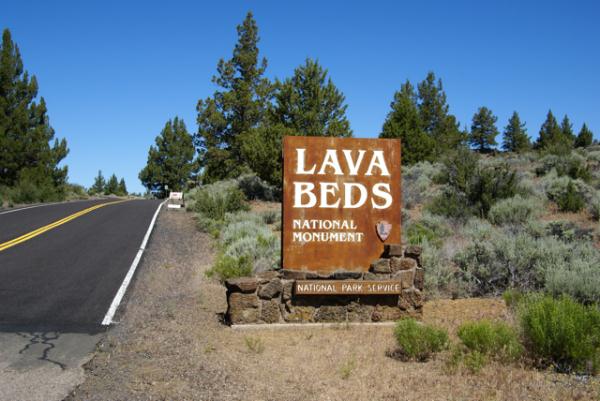
Because of the distance involved, we chose to drive straight up to Lava Beds, foregoing any caching along the way. We figured, we wanted to optimize our time, and there was only one objective as far as caching went. So, without caching, we drove, then came in through the southern entrance. You can't really see much, but if you look at the entrance sign post, you can definitely tell where the county road ends and the federal road begins. The county road was a lot worse in spots and not well maintained.
Lava Beds is a very interesting spot. The park protects an area of former volcanic activity. If you look at a map of the United States, you could draw a line, stretching from Lava Beds, up to Yellowstone. That line would also pass through or be near Craters of the Moon National Monument, another area of volcanic activity. The present theory is there is a hot spot of magma underneath Yellowstone, fueling the thermal and volcanic activity there. This hot spot used to be underneath Craters of the Moon and then previously Lava Beds as the earthen plates moved over the magma.
Lava Beds is an area of volcanic flows and a great amount of lava tubes, places where lava flowed, then as the lava subsided, large empty tubes, or caves were left behind. Several of these tubes are available for exploring and we brought out flashlights along just for this occasion. The park also rents hard hats out, but we weren't going to be exploring some of the low ceiling caves, so we didn't take advantage of that. 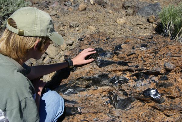 There were large amounts of lava rock alongside the trail and we spotted one of the largest pieces of obsidian, known as volcanic glass, that I'd ever seen.
Because the area is dry, these caves are not what most people typically expect caves to be, full of fanciful formations. They have mostly a rough interior, but there are very few formations of any kind, no stalactites, no stalagmites or flow curtains. They are, nonetheless, impressive to see with some being over thirty feet in diameter. We explored several, including Mushpot Cave, Skull Cave and Valentine Cave, so named because it was discovered on that ever important day.
Skull Cave, where the only virtual cache is located in the park, is particularly interesting. Named because of skeletons found in the cave, it descends down into the earth. There are metal staircases going down and at the bottom there can be found ice year round. It's not one of those caves you'd want to stay in for very long, especially if you were dressed as we were, for the 90˚ weather topside. We walked down, felt the ice on the floor of the cave and then retreated to the surface.
There were several caves in the park that had Native American petroglyph drawings on the cave walls. We hiked out to this cave and viewed those. Once again, I was struck by the toughness of life. At the entrance to one of these caves, there was a large tree growing out of the roof of the cave. 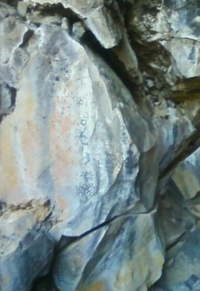 We could not see any of the roots coming through the roof, yet the roof was probably only about 10 feet thick. The tree was probably twenty to thirty feet tall. Just amazing that it had been able to grow that large with such poor soil possibilities for it.
We ended up driving through the park and exiting via the northern entrance, then headed back to Lassen. The park is located in Siskiyou County, a county that I had already found a cache, but we had yet to find a cache in Modoc County. Once outside the park, we were in Modoc County, so it was just a matter of driving down the road and finding some caches before leaving the county to get that particular county checked off for the 58 California County Challenge Cache.
Because of the time driving to and from, we probably didn't spend as much time as we could have there. I think if I were to do this trip over again, I would have decided to move camp and camp up at Lava Beds for a night or two, but the day trip worked well for what we wanted to do this trip. As always, the caching and the companionship were excellent, so it was a good day.
Pictures were taken at or near the following geocaches and waymarks:
Lava Beds National Monument - by Webfoot
Skull Cache - by ChrissySkyking + Blaze
Monday, August 2, 2010
Lava Beds

![]()
![]()
Subscribe to:
Post Comments (Atom)
1 comment:
Very cool! I added the Skull cache on my list of "to-do" caches. Thanks for sharing such a cool spot!
Post a Comment