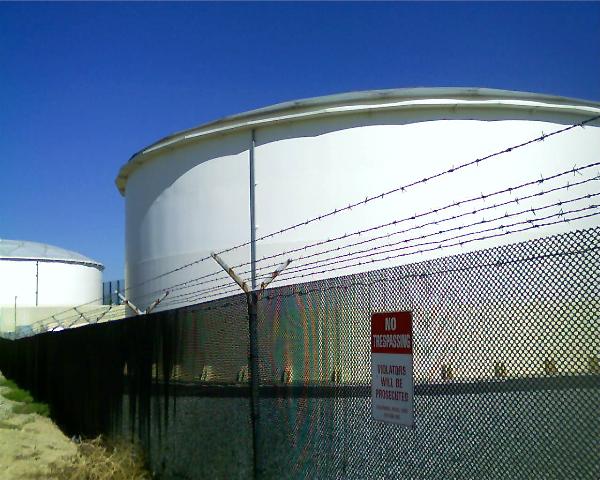
As noted in my last post, a straight line is not always the shortest distance between two points. That could not be more apparent than the route we took to get from Lassen Volcanic National Park up to Lava Beds National Monument.
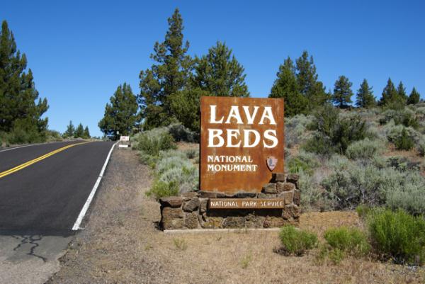
Because of the distance involved, we chose to drive straight up to Lava Beds, foregoing any caching along the way. We figured, we wanted to optimize our time, and there was only one objective as far as caching went. So, without caching, we drove, then came in through the southern entrance. You can't really see much, but if you look at the entrance sign post, you can definitely tell where the county road ends and the federal road begins. The county road was a lot worse in spots and not well maintained.
Lava Beds is a very interesting spot. The park protects an area of former volcanic activity. If you look at a map of the United States, you could draw a line, stretching from Lava Beds, up to Yellowstone. That line would also pass through or be near Craters of the Moon National Monument, another area of volcanic activity. The present theory is there is a hot spot of magma underneath Yellowstone, fueling the thermal and volcanic activity there. This hot spot used to be underneath Craters of the Moon and then previously Lava Beds as the earthen plates moved over the magma.
Lava Beds is an area of volcanic flows and a great amount of lava tubes, places where lava flowed, then as the lava subsided, large empty tubes, or caves were left behind. Several of these tubes are available for exploring and we brought out flashlights along just for this occasion. The park also rents hard hats out, but we weren't going to be exploring some of the low ceiling caves, so we didn't take advantage of that. 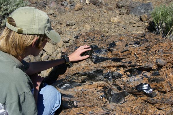
Because the area is dry, these caves are not what most people typically expect caves to be, full of fanciful formations. They have mostly a rough interior, but there are very few formations of any kind, no stalactites, no stalagmites or flow curtains. They are, nonetheless, impressive to see with some being over thirty feet in diameter. We explored several, including Mushpot Cave, Skull Cave and Valentine Cave, so named because it was discovered on that ever important day.
Skull Cave, where the only virtual cache is located in the park, is particularly interesting. Named because of skeletons found in the cave, it descends down into the earth. There are metal staircases going down and at the bottom there can be found ice year round. It's not one of those caves you'd want to stay in for very long, especially if you were dressed as we were, for the 90˚ weather topside. We walked down, felt the ice on the floor of the cave and then retreated to the surface.
There were several caves in the park that had Native American petroglyph drawings on the cave walls. We hiked out to this cave and viewed those. Once again, I was struck by the toughness of life. At the entrance to one of these caves, there was a large tree growing out of the roof of the cave. 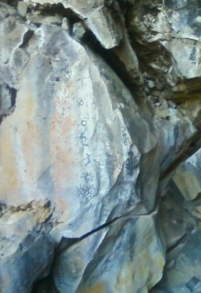
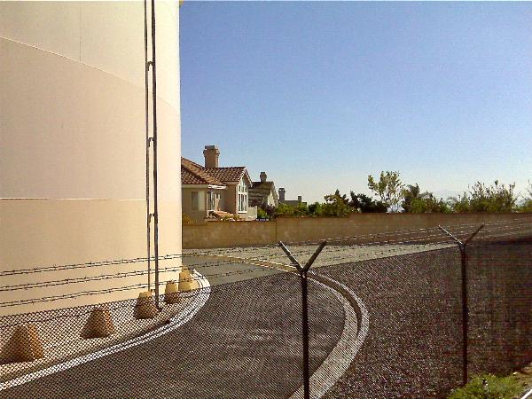
We ended up driving through the park and exiting via the northern entrance, then headed back to Lassen. The park is located in Siskiyou County, a county that I had already found a cache, but we had yet to find a cache in Modoc County. Once outside the park, we were in Modoc County, so it was just a matter of driving down the road and finding some caches before leaving the county to get that particular county checked off for the 58 California County Challenge Cache.
Because of the time driving to and from, we probably didn't spend as much time as we could have there. I think if I were to do this trip over again, I would have decided to move camp and camp up at Lava Beds for a night or two, but the day trip worked well for what we wanted to do this trip. As always, the caching and the companionship were excellent, so it was a good day.
Pictures were taken at or near the following geocaches and waymarks:
Lava Beds National Monument - by Webfoot
Skull Cache - by ChrissySkyking + Blaze
Monday, August 2, 2010
Lava Beds

Tuesday, June 22, 2010
Kill Bill meets an Elephant
A couple of months ago, I posted about simulacra, the waymark where inanimate objects look like real live things. Earlier this month, I was out in the desert finding a multi-cache. The cache was a simple offset, where you find something, or go to a set of coordinates and then walk a certain direction away from those coordinates to find the cache. 
The original spot, as stated on the cache page, was at a sleeping elephant. OK now. Give me a break. A sleeping elephant out in the desert of California. Maybe in Africa, but not here. Whoa! Yep, that's a sleeping baby elephant all right. Besides finding this cache, it also gave me the opportunity to post a waymark in the simulacra category for a sleeping baby elephant. An added bonus was also posting a waymark in the movie scenes catergory, since the title of the cache is called Kill Bill's Church. The church across the street from the elephant was used in the Kill Bill movies.
I always enjoy stumbling across stuff like this. I was actually surprised that neither spot had previously been waymarked. With the title of the movie as part of the cache description, one would think that some other geocacher would have thought to look on waymarking.com and done a search for it. I did and found the nearest waymark to be 16.1 miles north of the spot, which gave me a pretty good indication that neither had been waymarked.
The problem, as I see it with waymarking, is you really don't know what's out there until start clicking on links on the geocaching site. I have never been able to find an easy way to navigate around on the waymarking site. When I wanted to waymark the piece of the Berlin Wall that's standing at the Reagan Library in Simi Valley, I wasn't sure where to start. I think I started with a search of Berlin Wall. Eventually, I figured that it would best fit in the Preserved Architectural Remnants and Ruins section. 
I'm sure I could probably do a lot more waymarking than I do, but I don't know the criteria for each category. There's almost 1000 different categories of different things, so for the most part, I stick to what interests me and stay there, although the movie category isn't one of the categories I usually end up submitting waymarks to, the Kill Bill Church being the first one. I just happened to get lucky that I had taken a picture and had all the requisite information for the submission.
I sometimes think that since the removal of virtual caches from Geocaching, Waymarking has become the ugly stepsister of Geocaching. They're not really sure what to do with it and so it just sits there, getting bigger, but not really improving in any way. The geocaching site gets makeovers on a regular basis, but I don't see that happening on the Waymarking site. That's a shame, as I think the site could be better utilized if it were better organized. But then again, perhaps that's the best it can be, because of the scope of it.
Pictures were taken at or near the following geocache:
KILL BILL'S CHURCH - by fear it caches

Saturday, June 12, 2010
A rose by any other name...
This past week, I went on a short road trip to Northern California. I know short is a relative term, but it was short for me in time, as opposed to distance since I put slightly over 1000 miles on the van, plus added two new front tires during the trip.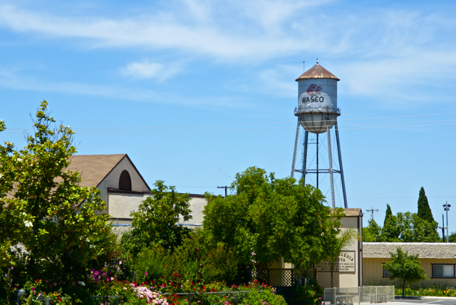
I drove up to Stockton, mainly to deliver extra "stuff" to my daughter, including a couch that she'd gotten from her grandmother, but couldn't fit in her car. There would be a side trip to Santa Cruz to pick up my son as well. Since he wanted to visit with his sister for a little bit, I picked him up, then drove back over to Stockton. This should have been a 4 hour round trip, but it ended up being over 8 hours because a problem developed on one of the front tires and I had to get that fixed before we could head back. Things happen and there's not much I could do about that.
Each time I drive up there, I try to take different routes. I look at the different virtual flags that can be captured, as well as any possible dashpoints, plus geocaches and then I plan my route accordingly. Waymarks and benchmarks are side possibilities, but for those, I just let them happen as opposed to me actively search for them.
If you've followed this blog for any length of time, you know that my most active waymark category is water towers. I love driving into small towns and seeing their town advertised for miles by the large water tower in the center of town. We have few water towers in Southern California, as most municipalities build large storage tanks in the hills above town which provides the same purpose of creating water pressure for the town's water supply.
Towns in the Central Valley of California and elsewhere where no hills are present create their town's water pressure by building water towers. Usually, these water towers promote the city, but some support advertisements for local businesses. The main water tower in Merced, California promotes the newest university in the UC system, UC Merced.
As I drove through the Central Valley this week, I happened to drive through the town of Wasco, CA. I've seen signs pointing to Wasco while driving both Hwy 99 and I-5, but have never gotten off, mainly because the town is out of the way. 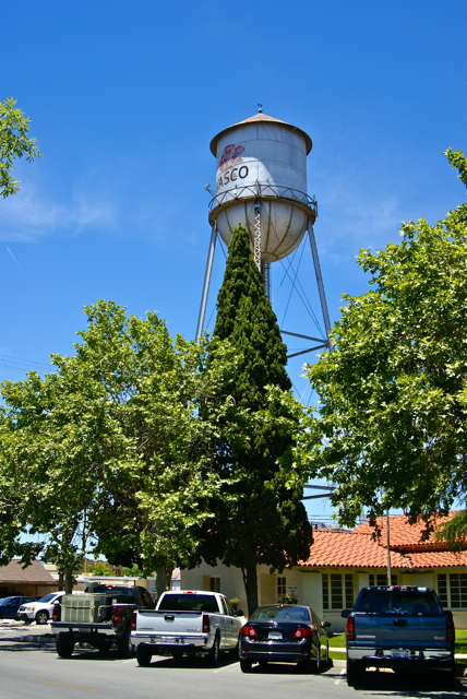
Had I known a little bit about the town, I might have been tempted to stop there sooner. Wasco bills itself as the Rose Capital of the World. Every year it has a rose festival the weekend after Labor Day weekend and the water tower in the middle of town is plastered with a large red rose. After getting home, I discovered that 55% of all roses grown in the United States are grown in and around Wasco by nine major rose companies. It was a pleasant experience to drive through the fields around town and see rows and rows of red roses, then rows of yellow roses. I know I've never seen so many roses in one place before.
If not for the GPS games that I play, I probably would have never passed through this quaint little town. I feel, I'm richer in spirit because of this hobby. If you happen to be in the area on the weekend after Labor Day some year, I think you could do worse than to make a stop in Wasco and take in their Rose Festival.
Pictures taken at the Wasco Water Tower:

Saturday, April 3, 2010
Simulacra
The game where everyone would look at the clouds and tell everyone else what they saw is popular, even today. 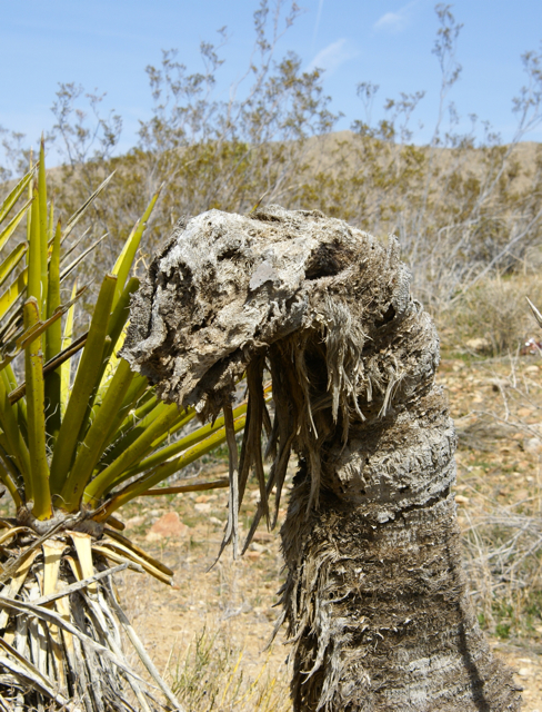
Simulacra, as defined by the Waymarking site, are inanimate objects, usually stones, rock walls, old tree trunks, plants, patches of peeling paint, rust spots and so on that have uncanny resemblances to inanimate things. I came across one of these while out hiking, took pictures of it, yet didn't have the presence of mind to take some geographic coordinates.
The first time I became away of Simulacra, was just after Waymarking became its own separate entity. I had been looking through some of the different categories, trying to get a sense of what the entire site was about when Simulacra caught my eye. I had one in mind right away. I was pretty sure there had been a locationless cache for Simulacra and my boys and I had spotted a tree that had a trunk shaped in what looked like an old man with a flowing beard. Since The Lord of the Rings movies were in theaters at this time, we fancied the old man to be Gandalf the wizard.
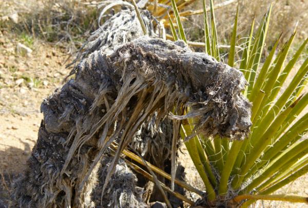
We never went back camping to that part of California before they shut down the locationless sites and moved them all over to Waymarking, so that was one of those that got away. Another one that got away was one that I spotted while out walking the Groundspeak Series of geocaches that Chaosmanor and I found on the 13th and 20th of last month. There was an old dead gnarled Joshua Tree lying in the river bed. As I approached it, I kept looking at it and thinking where have I seen that before?
Then it hit me that it looked very similar to one of those pictures that have been posted about the Loch Ness Monster. Up close, it wasn't so apparent, but farther away, it certainly looked like Nessie until I walked to the other side. Then it looked like Sebulba from the movie The Phantom Menace of STAR WARS fame. For those uninitiated, Sebulba was a champion pod racer who'd stop at nothing to win. In other words, he cheated. He finally met his match halfway through this movie when a young Anakin Skywalker beats him. As he crashes and burns out in the Tatooine desert, his famous last words are "Poo Doo."
Pictures were taken at or near the following geocache:
Groundspeak Series - Charter Member - by HDGC

Saturday, February 27, 2010
The King's Highway
Growing up in Orange County, California, I was constantly reminded about local history during school, plus my parents took us to many historical locations around where we lived so that we knew about the local history of both Orange County and of California. Local history, no matter where you happen to be can be quite fascinating. When we went on camping trips in summer to other states, my dad would always make sure that if we were near a state capital building, that we'd get a picture taken near it, or try to arrange a tour of the building.
I've eaten a picnic lunch on the grounds of the state capital building in Cheyenne, Wyoming. 
Part of the history of California is El Camino Real, the King's Highway, which stretches from San Diego to Sonoma where the Bear Flag Revolt happened, that started California on its way to independence from Mexico and eventual statehood in 1850. El Camino Real was a road developed over time to link up the missions established by Father Junipero Serra. Fr. Serra helped establish 21 missions in the late 1700s and early 1800s along the coast of California and there became a need to link them together for transportation and economic purposes. Thus became, El Camino Real.
The actual road today is, for the most part, gone, but there are bell markers along the side of Hwy 101 for most of its length between Sonoma and San Diego indicating where the original road had been. Other highways are also incorporated into the King's Highway, but the 101 is the main artery north and south of the central coast of California where most of the missions were constructed. As we were driving down the 101 from our trip north a couple of weeks ago, I noticed several of the bell markers. There is a Waymarking category for the bells and since I'm going to be using the 101 on a frequent basis over the next several years because of my son's choice of schools, it makes sense to put this one on my waymarking list of things to watch out for in the future.
As is our custom, we found several geocaches on the way down from Santa Cruz, including two at Mission Nuestra Señora de la Soledad, which was established in 1791, the 11th of the 21 missions to be so created. 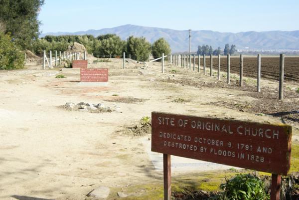
There also appeared to be some archeological digs going on behind several of the main buildings at the mission and it's probably a work in process. The mission is 2 miles away from Highway 101, and probably doesn't get many visitors, which probably means that funding for projects are not nearly as plentiful as they would be in Orange County where San Juan Capistrano is located.
We toured the two buildings, which included the church and chapel of the mission, looking at the exhibits first before heading out to get the information needed for the virtual cache there or finding the regular cache hidden by the entrance to the grounds. It was a nice quiet spot to get out and stretch our legs and learn a little bit more about California. I have now visited 6 of the 21 missions, with Soledad being the farthest north. I'm sure there will be more opportunities in the next couple of years to visit other missions along the King's Highway.
Pictures were taken at or near the following geocaches:
Mission Possible - by needlepointone and zieber
Mission: Soledad - by Great Scott!

Sunday, October 25, 2009
Tanks
Yesterday, the Tadpole had a cross country meet at the Mt. Sac Invitational Cross Country meet, one of the premier running events in the country. I decided that I could cache in the area with my friend 3blackcats and then head over to Mt. Sac to watch him run. Unfortunately, he woke up not feeling well and so didn't run, so most of my day was spent caching.
We found a number of interesting caches in the area and had a pretty strenuous hike right after lunch. We were trying to find one cache, but couldn't find a way in, so headed to the next cache and missed a small cutoff trail that would have led us right to the cache. We didn't realize that was happening until we'd gotten all the way to the top of the hill. The trail kept switchbacking on us, taking us tantalizingly close, them drawing us away so we thought we were on the right track. It wasn't until we got almost to the top that we realized that we were finally walking away from the cache.
A quick check of the GPSr showed that we were 21 feet away from another cache which we found. We were also very close to a couple of water tanks, which I took pictures of figuring I could waymark the water tanks in the water towers and tanks category. There was another cache just beyond the tanks, so we ended up going over to that one as well. There were some nice house up on that ridge with views of two different valleys. Talk about multi-million dollar views.
On the way down, we ended up finding a way into the original cache we'd started out to find. So, in retrospect, it wasn't a bad idea to go after that one cache. We ended up getting two extra bonus caches because we couldn't get to the first cache right away, plus I was able to waymark those two water towers. It was a pretty good day.
Pictures were taken at or near the following geocaches:
El Gordo - by UNCLEJON91
You Can Start Here - by UNCLEJON91

Wednesday, July 1, 2009
More History
Today the Tadpole and I decided to visit the Nixon Library. One of the draws was the "World's Largest 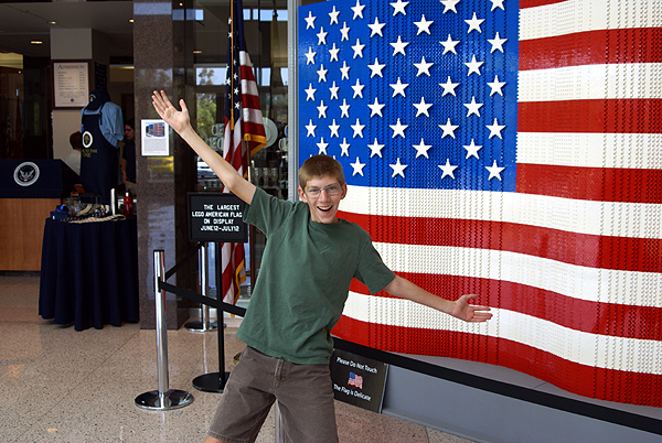
We paid the admission price, spoke with a docent for a little bit to plan our day and then we were off to explore. Being early on a weekday, the place wasn't crowded at all so we decided to visit the President and Mrs. Nixon's graves first. I decided to take a couple of pictures, being fairly certain that Mrs. Nixon's grave hadn't been waymarked in the Grave of a Famous Person waymark category. I'm still waiting for approval on that particular waymark.
After paying our respects, we then headed over to his home where he was born and toured that and then it was off to walk through Marine One, the helicopter that 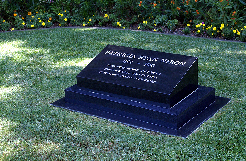
Then it was time to tour the museum. The museum has most of the factual parts of Nixon's life down and there are some interesting displays throughout. My favorite part is the hall of world leaders. In this room, there are life sized models of the world's leaders from Nixon's time as Vice President and President. This was the third time I'd been to the Library. The first time was a month after Nixon had died and the crowds were huge, so they had the area roped off, so you could only view them from afar.
Two years ago, my daughter and I revisited the library and that time we got to walk among the leaders. 
The first thing that stands out is how short Nikita Khrushchev was. He was one of the most powerful men in the world and yet stood only 5 foot 4 inches tall, proving that size doesn't really matter. As you can see in the picture, he's several inches shorter than the Tadpole who stands 5 foot 7 inches tall. The next thing that stands out was how massive Charles DeGaulle was. Once again, compare his statue with the Tadpole standing right next to him. I estimate DeGaulle to be almost a foot taller than my son. DeGaulle was truly bigger than life.
Leaving this exhibit, we entered another exhibit that had several international exhibits including a segment of the Berlin 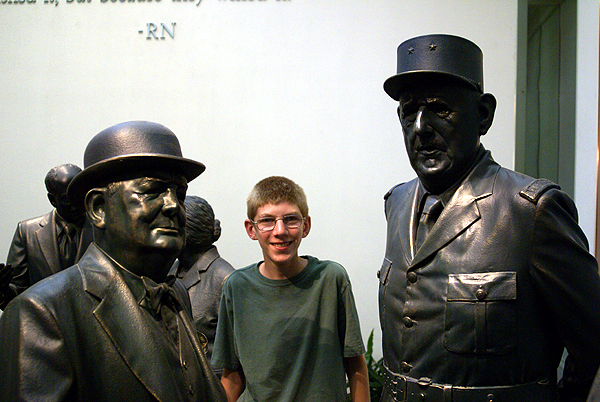
So today, I saw a second segment of the Berlin Wall, just about 10 days after seeing one at the Reagan Library. I knew for a fact that this segment at the Nixon Library hadn't been waymarked, so I took a picture. I'm not sure the picture is the best since I had to hand hold the camera as the library doesn't allow flash photography inside the building. But I now own two waymarks concerning the Berlin Wall, the Reagan segment which I waymarked last month and now the Nixon segment which was approved today in the Preserved Architectural Remnants and Ruins category.
At the moment, we have 12 Presidential libraries, one for every President from Hoover through Clinton. 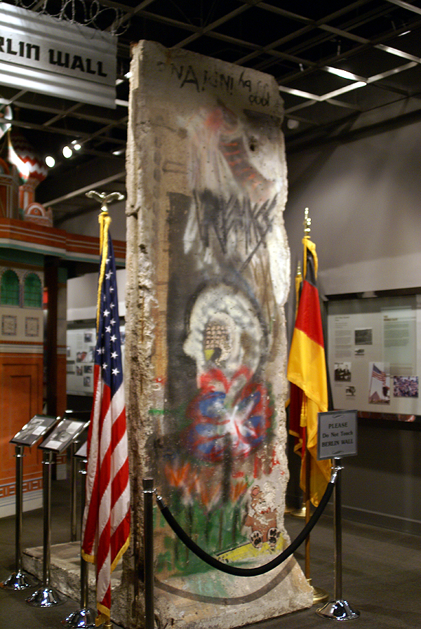
Before the National Archives took over the Nixon Library in 2007, there wasn't a lot of information on Watergate in the Nixon library. They'd started changing this when I was there two years ago with my daughter, but they still have a lot to do before it's complete. One piece of paper in this part of museum was very striking in its simplicity and that was Nixon's resignation letter to the Secretary of State, Henry Kissinger. It simply stated, " I hereby resign the office of President of the United States." Dated August 9th, 1974, it was received and initialed by the Secretary of State at 11:35 AM. Interesting how simple the transfer of power can happen in our country.
Pictures were taken at or near the following waymarks:
Berlin Wall Segment - Richard Nixon Presidential Library

Monday, June 22, 2009
History and waymarks
This past Saturday, I took the Tadpole out to the Reagan Presidential Library in Simi Valley. We cached a little bit before heading over there around 10:30 in
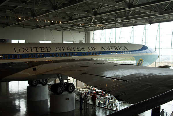 President traveled. Unfortunately, they wouldn't allow photography of the inside of the plane, so I can't show any of those details. Suffice to say, it's not your ordinary plane. After getting home, I ended up "visiting" a current waymark in the Static Aircraft Displays category.
 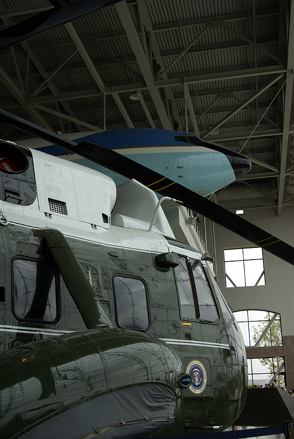 larger than the Declaration of Independence, inside a glass climate controlled case. This particular copy usually resides at the Lincoln Cathedral in London, but is also designated the "traveling" copy. It's been in the United States before, most notably in late 1939. That stay lasted a little longer than anticipated due to the outbreak of World War II. The US government kept it for the duration of the war, storing in at Fort Knox next to the original Constitution.
 At the edge of the lawn is a full segment of the Berlin Wall that was presented to President Reagan by the Berlin Wall Commemorative Group in 1990. We took pictures there and then headed over to the east side of the lawn to pay our respects to the President at his grave site. After getting home, I also "visited" the waymark for his grave in the Grave of a Famous Person category.
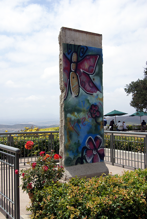 I hadn't gotten coordinates for the wall when I was there. Fortunately, I was able to use the USGS map locator to pinpoint the coordinates for the Berlin Wall segment. Using the satellite view, I zoomed in on the wall at the library. By putting the cursor over any point on the map, the map locator gives a coordinate reading for that point. By zooming in to its closest point, I was able to get very accurate coordinates and now have an approved waymark in the Preserved Architectural Remnants and Ruins waymarking category. Next time you're in the Simi Valley area, stop in at the Reagan Library and visit my waymark.
Monday, May 25, 2009
Geocaching and waymarking
This past Saturday, I was able to get out for the first time in a week to do some geocaching. The Tadpole and I met up with Chaosmanor near Hollywood to do some GeoVexilla and some geocaching up north of 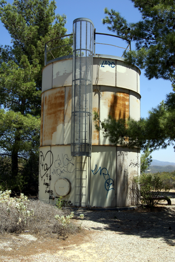
Along the trail, on a ridge overlooking the lake, we came upon an old water tank. I'm not sure what area or town was being serviced by this tank, but it was clear that this tank had seen better days. As you can see by the picture, the tank has been struck by graffiti numerous times. Surprisingly, there wasn't a lot of trash in the area, probably because the narrow road leading up to the tank and beyond had a locked gate on it. Too often, less populated area tend to become dumping grounds for people that either can't afford the fee to take their trash to the dump, or don't want to be bothered. Places, that could be very beautiful, become blighted in the process. At least this hadn't happened here outside of the graffiti.
The tank was situated in a copse of pine trees. The trees were obviously planted to obscure the tank, making it less of a public nuisance. I decided I'd waymark this tank, since the water tower category is one of my interests at Waymarking.com. We continued our hike beyond the tank and came to the cache we'd set our sights on earlier in the day. This particular cache gave us a lot of trouble because it was well hidden. My GPSr kept telling me I was at ground zero in the middle of the trail, only about 6 feet away from the cache, yet I never did spot it. All three of us probably walked right by it several times. Eventually, Chaosmanor spotted a small portion of the lid of a decon container peeking out and we had the find. The view from 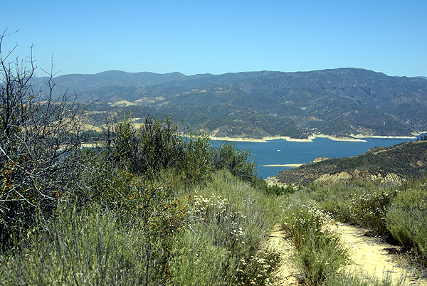
After finding that cache, we headed down below our parking area to another cache. This particular cache had been hidden west of a former picnic area overlooking Lake Castaic. Unfortunately, the area had been closed for some time. The road down was in disrepair and the picnic area were overgrown with weeds. The two bathrooms had been totally trashed and it was evident that the local graffiti artists had been at work on several of the structures.
We would have actually missed most of this had we paid better attention to our geosenses and GPSrs. At one point, we had the opportunity to either stay on the road, or take an overgrown trail. It looked like the road was going to take us to the same place, so I opted for that route, since the main overgrowth on the trail was foxtails. Anyone who knows me very well knows that I detest foxtails. In reality, we encountered foxtails all day long so it really wouldn't have made much of a difference and had we taken that particular trail, we would have avoided all of the graffitied buildings, etc. that we passed on the hike.
Eventually, we ended up out on a point overlooking the lake. The GPSrs were pointing us in a variety of directions, but we didn't have much room to maneuver around because the trail became, in Tadpole's words, "Uber steep." and would have become treacherous had we continued, so I figured 
The hike back up was strenuous, but we made it up without too much difficulty. In a couple of months, the trail will be very difficult because of the summer heat. There was little to no shade. Hopefully, someone else will be down there to pick up the travel bug, otherwise it might stay there awhile. All in all, it was a good day. But then again, when I go out caching with the Tadpole and/or Chaosmanor it usually ends up being a good day.
Pictures were taken at or near the following geocaches:
Lake View Cache-taic - by Team Magpie
Below the Castaic Overlook - by Don J

Saturday, December 27, 2008
Environmental Awareness
This is not what most of you probably think it's about. When I first heard about locationless caches, it was in February 2002, 
There were several things that I liked about locationless caches. I may be wrong, but I think you had to have a picture taken at your locationless find in order to get credit for the cache. I liked that, since there was no log book to prove you'd actually 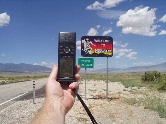
Probably the most famous of the locationless caches was Yellow Jeep Fever, where you had to get a picture of your GPSr with a yellow jeep. Sound easy? Not really. I can remember right after I discovered locationless caches, I was driving up to Lake Arrowhead and I passed a yellow jeep going the other way on the road. It was very frustrating to see something that you could log, yet not be able to for safety reasons. I actually saw another jeep, possibly the same one, when I was heading back down the road later that same day. I eventually found a yellow jeep in a parking lot in Upland, CA while I was out doing some other caching. I'd stopped to find a cache, looked over, and there was a nice jeep with Colorado license plates parked rigth there.
There were so many locationless caches during their heyday, that it was virtually impossible to keep track of all of them. 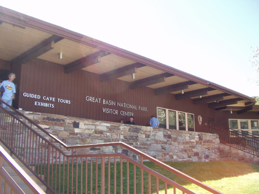
Every time we'd I would make sure we'd find a couple of the locationless caches. Some are very easy, like an American Flag. Since we would always camp in national parks, it would be fairly easy to get one of the American Flags at the park headquarters or visitors center. That same trip, I also wanted to get a park headquarters locationless too, but 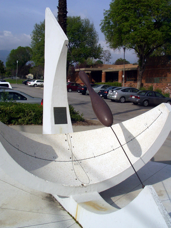
That particular year we were going to be camping at Cedar Breaks National Monument in Utah and Great Basin National Park in Nevada. I figured I'd be able to get an American Flag at one park and the park headquarters at the other park. I ended up getting the national flag before we got to either park. We'd stopped for gas in Mesquite, NV, right on the border of Nevada and Arizona along I-15. Across the street from the gas station is the Oasis Hotel and Casino. Flying out in front of the casino is the largest American flag I've ever seen, so I decided to waypoint it and take a picture of it just in case. When we got home, I discovered the flag hadn't been logged as a locationless cache yet, so I decided to log it.
Locationless caches were all archived in January 2006 and have been moved over to the Waymarking site that Geocaching.com also maintains. It's basically the same thing and yet it's not. Keeping track of locationless caches on Geocaching.com was easier for me at least. I know there are some people that have embraced Waymarking. I can take it or leave it at this point. I am an officer in the Water Tower group at Waymarking, but I haven't marked a water tower in quite some time. 
When they were around, I found 25 locationless caches. Of those 25, I think I'd still try to find 24 of them again if I could. Ironically, the one that I wouldn't find again, was the one that got me started with them. It was called Where's in a Name? and it involved getting help from someone on the other side of the world to help you log the cache. I wasn't at a particular point to take a picture and get credit for the cache. But it did get me interested in the overall pr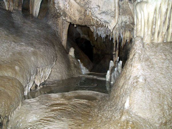
And yet, as the locationless helped me become a little more observant about what was around me, it also didn't for some reason. I know that doesn't make sense, but when I logged the observatory locationless, there was a virtual cache at the same location. For some reason, I wasn't aware of this virtual until a couple of years later when I got back up to the same area and logged the virtual. To this day, I'm not sure why I didn't log the virtual at the same time.
Pictures were taken for logging the following locationless caches:
Yellow Jeep Fever - by Team CBX2
Make a Break for the Border - by The Dam Trolls
NPS HQ - by MartyFouts, Adopted by bullit
Sundials - by outforthehunt
Observatory Quest - by Anton
Speleo - by Melak

Monday, August 11, 2008
Discrepencies
It's interesting how different GPS units measure the same information. This past Saturday, my friend Chaosmanor and I went out 
The first dashpoint we attempted, our GPSrs were agreeing with each other almost down to the smallest detail. The picture of our two GPSrs are each pointing at the rock in the center between the two. When they were placed down, they both read zero. After we had taken our pictures and notes, we looked at the GPSrs and they were both pointing at the rock and registering 1 foot away.
Surprisingly, later in the day, at our last dashpoint, the closest we could get to one another while trying to zero out on the point was about 25 feet. We've noticed similar things on other caching trips we've taken, but usually it's a difference between makes, the old Garmin vs. Magellan type of thing. Saturday's discrepancy was between different models of Garmins. I have a eTrex Legend C and his, I
Pictures were taken out in the Antelope Valley near dashpoints:
GD86-AKAP
GD86-AKOR
Saturday, July 12, 2008
Stuff Happens
Sometimes when you're out caching, nothing happens you have a great time and everything is good when you get home. 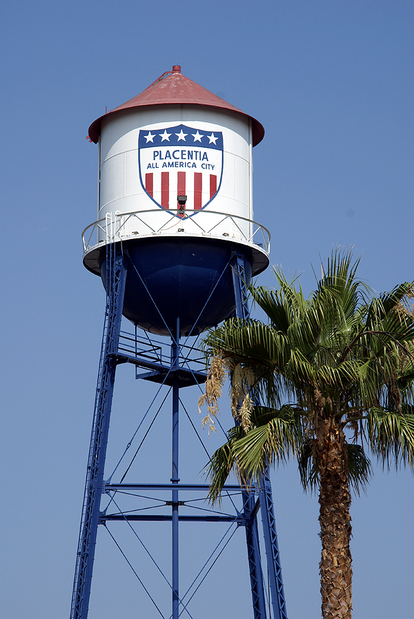
I took my younger son out to play with the GPSr today. The first thing we did was capture the flag of Bermuda. I wasn't sure whether it was actually going to happen or not, since I'd pretty much realized before we went that the flag was going to be behind a gate, but I figured that we'd get close enough that we'd score the point, which we did. We also waymarked a water tower today. I've mentioned that particular water tower at the bottom of this post, and we finally were able to get back to get it today.
The caching was fun. There was a neat puzzle that I'd solved about a year ago that I finally got around to finding. The rest were small caches, a couple of which had geocoins in them, another was large enough to place a travel bug in. But what happened to me at some of the caches makes me wonder whether I just should have stayed home. Let's see, let me count the injuries.
Injury one happened when I didn't heed the warning on the cache page. The warning stated,
"A note of warning, it seems many people are getting whacked on the head with this cache so please be carefull (sic) and watch your noggin."
Now, my thought process was that the cache could fall on you. I really didn't have a clue other than that until about 15 seconds after 
Two caches later I bumped my head looking for a cache under a bridge. After I came up for air, I noticed that the GPSr was now pointing 40 feet away from where I'd been looking under the bridge. Yep, that's where it was, but now I had matching bruises on each side of my head. The very next cache, although there was a good amount of time in between the two since we'd made a stop for lunch, I ended up slipping on a slope of grass and landed on my rear, rather unceremoniously. I have to give my son credit. 
Two caches later, in a parking lot no less, I apparently brushed my hand up against some stinging nettles. Now I've touched stinging nettles in the past and they really do sting. This felt exactly like it, but it was really in an odd place, in a parking lot, on one of the many landscaped islands that you can find in any local Big Box parking lot. Very strange, but over three hours later and my finger was still feeling the effects of it.
Fortunately, that cache was the last cache of the day, otherwise who knows where I'd be if I'd continued caching today, perhaps in traction? I guess this is more of a public service announcement more than anything. Injuries do happen. The slip could have been avoided, the head bumps as well. The stinging nettles was unexpected, but at least to protect myself in the future I need to remember to use glove whenever I'm working around plants of unknown origin. There's a lot worse things out there than just stinging nettles.
Pictures were taken at the following waymark:
Placentia Water Tower - by Webfoot

Wednesday, July 2, 2008
The Sounds of Caching
We all see the sights of caching all the time. For the most part, caching is a very visual experience, which is one of the reasons why we spend so much time making the camo on our caches just right. 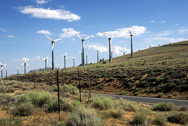
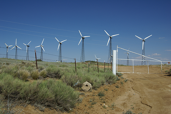
Last week, I was fortunate enough to find one of those caches where the area literally sang to us. The cache is called Pass Cache, and it's located along the Tehachapi Willow Springs Road, right at Oak Creek Pass leading from the Antelope Valley up and over to Tehachapi. It's also an area of high winds and there's some enterprising business that's taking advantage of it by placing windmills all through the area. If you've ever been through Palm Springs along the I-10 leading away from Los Angeles toward the Colorado River, you know what I mean. These windmills are huge and they catch the wind and generate electricity.
Now, whenever I've driven out to Palm Springs, I never had my windows open, mainly because I'm driving 70+ mph along the interstate and it's usually hot out, so I have the air conditioner going as well. I've never had the chance to actually 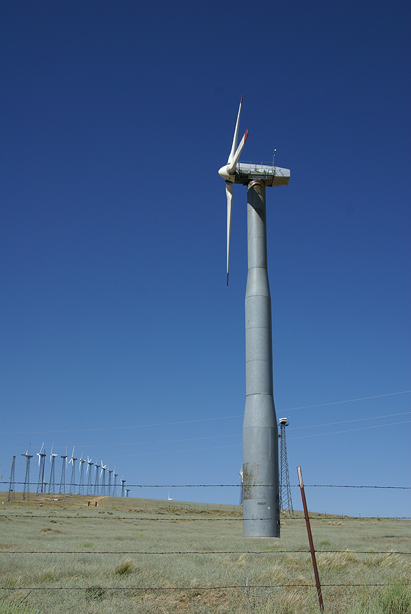
As soon as we got out of the car, my prime concern was finding the cache. It was hot that day and we hadn't been spending a whole lot of time outside of the car because of it. Immediately I was struck by the sounds I was hearing. To me, my first impression was that of a very large windchime, the kind that many people have in their back yards that catch the breeze and give back pleasant tones on a cool summer evening. These were just like that, only very deep in pitch. We kept hearing different frequencies, but there was an ethereal quality to it all that made the entire experience quite haunting. I noted to Chaosmanor what I thought it sounded like and he said that he heard singing.
Hmmmmm. Now I couldn't hear the singing that he defintely said he heard, so in my mind, that made the place even more interesting. We were hearing the same thing, yet they were saying different things to each of us. Then I heard the singing too. About five feet from where the cache was hidden, there was a benchmark, so I had to go back to my car to get the camera so I could document it as well, and that's when I heard the singing. It literally sounded like some kind of Gregorian chant, or possibly some druid elves chanting to each other. You couldn't understand it, but you definitely knew it was singing. It was a very cool effect and all done by the wind and these windmills.
Usually on a large cache hunt like I did that day, I'll go back over them and think about the coolest cache that I found that day. I keep a running 5% bookmark list, of what I consider the best caches that I've found. The list is constantly in flux with additions and subtractions occuring when some caches get archived and when I find new ones that I think fit the bill. The list includes caches that I find whimsical, or that I found particularly challenging, or they could be on the list because of the great view. This one was a no brainer to make the list because of the experience. I got to find a cache, I got to document a benchmark and post a visit at waymarking and I got sung to all at the same time. You really can't beat that in my opinion.
Pictures were taken at or near the following geocache:
PASS CACHE - by rborch

