While on the road trip this weekend, I found a cache that had a benchmark nearby. The cache page even stated there was a benchmark nearby. As I've stated numerous times in the past, I usually don't go hunting benchmarks, but if they present themselves to me, I'll log them.
The Altamount Silo find was sort of like a comedy of errors. 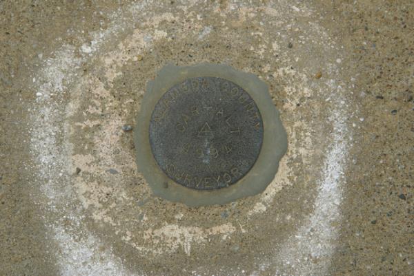
The benchmark page at Geocaching.com is pretty specific on how to log a benchmark. Unfortunately, they don't require a picture of the benchmark in order to log it, which in my opinion is wrong. The picture backs up the find and also points out possible errors, should the person get the wrong benchmark. There is another section on the benchmark page that educates people on whether they have the correct benchmark or not.
This particular benchmark is supposedly very close to the Altamount Silo Geocache. Looking at the two maps, they are indeed very close, but if someone is going to log that benchmark, they really need to find it first. I didn't and realized it as soon I got home and looked at my pictures. The designation for the benchmark is K 1258. That means you're going to see those combination of letters and numbers are going to be stamped into the benchmark somewhere, especially if it's a disk.
When I got home and looked at my picture of the disk, I noticed that it was clearly labeled Alameda County Surveyor around the outside of the disk and CAR-ALT and 1994 stamped in the middle. Anyone, who had taken the time to read the benchmark description page would have noticed the discrepancy in the designations, plus the other clue of the date. The 1994 date on the disk doesn't match the description of the other disk, which was set in 1974, twenty years earlier.
The sad thing is people are still logging the benchmark as found. I'm not a serious benchmarker by any stretch of the imagination, but I can imagine that this would frustrate people who are. They might plan a trip out there, then realize that the disk isn't the correct one. 
Maybe I'm picking nits on this one, since it's just a small aspect of the overall hobby, but there's something wrong with claiming a find when you haven't found it. I think partial responsibility rests with geocaching.com. If they're going to list this on their site, then they should police that area, but that's not happening. And so, people are being misled.
And the flip side of this is, don't know that this disk is the wrong one. I didn't until I got home. The difference is, I checked before I logged it, realized that it wasn't the correct one, and so didn't log it. Others are following through like that. I guess I'm hoping for a perfect world where everything runs, uh, . . . yeah, perfectly. All caches would be found, benchmarks would be logged accurately, people wouldn't lose their GPrs, and gas would only cost 35¢ per gallon. Well, we know that's not going to happen, but I think I just needed to get that off my chest anyway.
Oh, and when I got back to the van and got ready to take off, I realized that I didn't have my GPSr with me. I checked the van thoroughly and didn't find it there, so I went back to the cache and found it lying on the ground about four feet away. Usually, when I find a cache, I place my GPSr on the top of my foot, since it's likely that were I to walk off, I'd feel it fall off of my foot and remember that I need to pick it up. For whatever reason, this system failed me this time. At least I wasn't 20 miles down the road before I realized it though.
Pictures were taken at or near the following geocache:
Altamount Silo - by Kenny162
Tuesday, June 15, 2010
It's the wrong one people...

Friday, May 28, 2010
Broken Benchmark

I think one of the reasons I didn't enjoy benchmark hunting at first is because when I "discovered" benchmarking, I immediately went out and tried to find the closest benchmarks to where I lived, only to come up empty on four or five attempts. Being a rookie to this particular GPS activity, I didn't know all of the ins and outs at the time. I'm not saying that I do now, but I understand what to look for and how to look better than I did 6 or 7 years ago.
The first benchmarks I went hunting weren't there, because of the federal government. The Feds didn't destroy them, rather other agencies probably inadvertently destroyed them, while complying with the American Disabilities Act (ADA). I had been looking for disks attached to curbs. When streets had been widened or worked upon, the curbs had to be made wheelchair accessible. New curbs were laid and the old curbs, which had the benchmarks attached to them were discarded.
In urban or suburban areas, I would suspect that many early benchmarks disappeared because of new construction all the time. In rural areas, without as much construction, benchmarks tend to last longer, which is why I find most of the markers on my list out in the desert. The marker that Chaosmanor and I went searching for was out in the desert, so we assumed that we'd find it in the ground where it should be according to the description listed on the benchmark page.
We were sadly mistaken on this account as we found the benchmark, attached to its concrete post lying on the ground. The benchmark was in the general vicinity of where it was supposed to be, but some kind of construction, or possibly a farmer tilling his field had pulled the post out of the ground.
Because there hadn't been any kind of report on this benchmark in over 40 years, we can only speculate as to when this took place. We both estimated that it had been several years at least that the benchmark had been in its present condition. 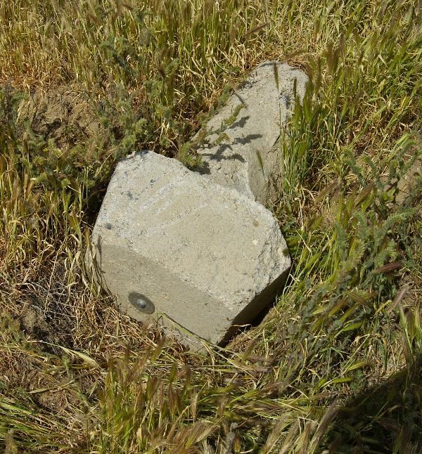
I'm going to assume that whoever pulled it out of the ground had one of those "Oooops" moments and didn't want to risk a fine, so decided to leave well enough alone and just disappear back into the desert environment. With that assumption, the hole would have slowly filled up over the course of a couple of wet winters and there would have been little evidence of where the post should have been in the ground. The post is about 3 feet in length, so three or more years would have been minimum I think to fill in a hole. Then again, the person who pulled it out, might have helped it along by refilling the hole.
Overall, the benchmark is in pretty good shape. It's just not useable the way it is, because it's not in the right spot. At least with a little detective work, we've been able to piece together a little bit of its history over the past 40 years.
Pictures were taken near the following benchmark:
EW0888

Sunday, December 13, 2009
Soledad Canyon
Driving through Soledad Canyon last weekend was an enjoyable experience for a variety of reasons. The canyon runs basically eastward from the 14 freeway toward Acton, California. As one nears Acton, the road starts to bend towards the northeast and continues that direction until it connects back up with the 14 freeway as it makes its way north toward Palmdale and Lancaster. 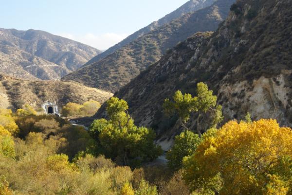
An active railroad right of way also runs parallel with the canyon road through the canyon. There were several caches along the road that had train themes to it, including a tunnel view cache. We heard and saw two trains go through the canyon while we were caching, but unfortunately, we were not in a good position to get decent pictures of either one. In fact, we missed a trail going through the tunnel view cache by a matter of five minutes. We kept hoping to see another train, and we eventually did, but the cache we happened to be near at the time didn't put us in a good position to train spot. Sometimes caching is like that and we accepted it.
The seasons in Southern California are relatively delayed as opposed to other areas of the country. We actually have two big blooming seasons, one in the springtime and one in the fall. Our fall colors (what we have of fall colors) usually happen in late November/early December lasting into the new year. It's finally getting cold enough at night that the trees are starting to drop their leaves in force. 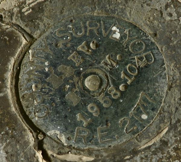
The road we traveled on had several old bridges on it. We were in a canyon, so we crossed Soledad Creek several times and also crisscrossed the railroad tracks in certain areas as well. I kept looking for benchmarks along the way and I found a couple, but nothing that was in the geocaching benchmark system to log. With the railroad tracks in play in the canyon, we both suspected that the benchmarks were probably tied to the tracks in some way and after getting home and doing a little bit of investigating, it became obvious that many of the benchmarks in the canyon were indeed along the tracks and not along the roadway.
The bridges we did cross were old enough they were dated. I can remember growing up, the sidewalks had dates on them in several places. The company that poured the cement would put some free advertising into the sidewalk along with the date the sidewalk had been poured. I hadn't seen this type of dating in a long time, as the other areas I've lived in were newer neighborhoods and the practice seems to have been abandoned over time for some reason. 
Bridges seem to have this same kind of dating system too. The company that built the bridge didn't put their name on the bridge, but at least a date could be seen on several of the one we crossed. One appeared to have been replaced as the bridge itself looked to be of a newer type of bridge, but the piers on which the bridge rests seemed to be the original pilings. Again, I found a benchmark near this one, but it was a small one and not listed in the system. The one that was listed in the system near this spot, was down on the railroad tracks. And so it goes sometimes when you're looking for benchmarks.
As I noted in one of my previous logs, the road was busy last week. There was an accident on the 14, so there were lots of cars using the canyon road as an alternate route to get around the backup on the freeway. Since we didn't get all of the caches in the canyon, we plan to go back in the future. Hopefully, the road will be a little more peaceful.
Pictures were taken at or near the following geocaches:
Train Tunnel View - by Yosemite John and Debbie
Thirties Train Tunnel - by Yosemite John and Debbie
Bridge to Shambala - by Yosemite John and Debbie

Monday, September 28, 2009
Reset more than once
After taking my son up to Santa Cruz for his first quarter at college I had an entire day to leisurely drive home. I took the 101 south to Paso Robles, then took the 46 east over to the Central Valley. 
At a spot just off the 46, I found a bridge that a cache was hidden near. At first I thought the cache was going to be attached to the bridge, but after surveying the bridge, I realized that it was probably down below in the stream bed. It was very hot that day and it was getting toward noon and I figured that with my low blood sugar and the fact that I was alone on this trip now, it probably wouldn't be prudent to expend much energy getting down to the cache and then climbing back up the embankment. I suspect I'll be driving that route many times over the next couple of years, so I'm pretty sure I'll have other chances to get that particular cache.
I did notice a very nice benchmark on the bridge. At first glance, I didn't expect it to be in the geocaching benchmark system since the benchmark was dated 1978. I was even more convinced that this one wouldn't be in the system since the cache page for the cache under the bridge stated that the bridge had been washed out in 1996.
Pictures were taken at or near the benchmark C617 Reset.

Wednesday, September 2, 2009
Wallace, Idaho
As noted in the previous log, we did some geocaching in Montana, then headed back to Couer d'Alene. Interstate 90 has some very scenic locations along it in the panhandle of Idaho, so we had ample opportunity to enjoy the outdoors as we looked for caches. One of our stops along the way, was in Wallace, ID, a small town, that obviously has become a tourist stop for vacationers to visit as they travel on the interstate.
The cache we found in Wallace was near the old train depot. Most of the tracks are now gone from this section of town. Looking at old photographs in the nearby museum, this particular train depot was a bustling building, serving both freight and passenger trains. Those days are now long gone as evidenced by the lack of track around the train depot.
The cache was an easy find with the name of the cache pretty much giving away its location, but it was still fun to find. After finding it, we noticed the depot was now a train museum, so we decided to pay the entrance fee and tour the facility. We also noticed a beautiful benchmark on the side of the building. Before touring the museum, I had to go back to the van and get the camera so I could document our visit to the benchmark. I took a couple of pictures and then we went inside to tour the museum.
Upon arrival home, the fun began. Well, I'm not sure it's fun, but it was interesting. When I looked up closest benchmarks to the cache we'd found, I found two that by all indications were supposed to be right on top of the cache. That probably meant that there was a good chance that at least one of them was the correct benchmark for the one we'd found. That, was not to be the case however.
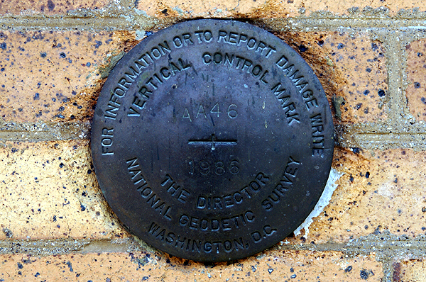
Of the two benchmarks listed, this one appeared to be the most promising based upon the description on the benchmark page. The description of the benchmark on the page states that this benchmark is set vertically in the south face of a brick building (the train depot) 4.5 feet higher than the sidewalk. The benchmark was monumented in 1935. That's where the confusion steps in, because the benchmark in the side of the depot is dated 1986.

There is also some geographic confusion. Since both benchmarks are fairly close, there really isn't a way to designate how many feet they are apart from each other if they are less than a tenth of a mile away. That means the database can say there's a benchmark right here, but it could be up to 528 feet away. This means that cachers should be extra careful when logging benchmarks, otherwise they're posting bogus logs for benchmarks they're not really finding. The benchmark information FAQ page indicates that one should try to take pictures of the benchmark, both a close up and one that places the benchmark in its surroundings.
For this reason, I don't log benchmarks that I find unless I've taken a picture of them at the time. I've been on caching outings where we've stumbled across benchmarks, documented them and when we got home, found there were two and three others in the same area. I know for sure that we probably walked right over one of them. But, we didn't take a picture, nor even see it, so I won't log it. And to be honest, I'm not sure why the logging of this particular benchmark, clearly the wrong one bugs me, but it does. I guess I need to get this out of my system since it's just a game and everybody plays the game a little differently.
Pictures were taken at or near the following geocache:
The Cow Catcher - by thehobbler

Saturday, August 29, 2009
Benchmark Buttes
After leaving Crater Lake, we headed up to Bend, Oregon where we were planning on spending the night with friends of ours. A real mattress and a hot shower were looking really good after tent camping it for the past week. 


Sunday, May 31, 2009
Desert disks
Saturday, I went up to the mountains to pick up my daughter. Obviously, since this is more about the desert than the mountains, I took a pretty circuitous route to get to the mountains. In fact, it was a rather longish route, but very fun.
I've been watching a couple of the virtual flags out in the desert and noting that several of them were about to expire, so I decided that Saturday morning would make a good trip out to get them. I created a bookmark list of caches along my intended route as well, so 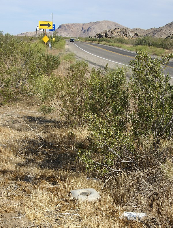
My route took my up the Interstate 15 into Victorville, then east toward Apple Valley. There I was able to score a Bhutan flag. I also found a small cache behind a movie theater. Then I proceeded east along a road the Tadpole and I had traveled in the past. My goal was to head to the northern border of Joshua Tree National Park, mainly because there was a cluster of 3 virtual flags out there, plus one nearby.
As I was traveling, I kept noticing some of the caches that had been part of my PQ show up on the screen. There didn't seem to be adequate stopping areas for many of the caches, or either I was driving too quickly to make good stops, but I was able to make one stop at a cache entitled, POINT. Team Christiansen has created a bookmark of caches in the Apple Valley that are placed near benchmarks. With 32 caches on the list, someone who is interested in benchmarks would be able to spend a rather enjoyable day out there finding caches and logging benchmarks.
After parking near POINT, I got out of my car and immediately spied the nearby benchmark. No, not just one did I spy, but three benchmarks. This was almost as good as the other cache where the Tadpole and I found five benchmarks in one spot. After finding the cache, I went over to document the benchmarks. There were three benchmarks aligned in a row just off the highway. After taking the requisite pictures of each, plus a picture of each so people could get perspective on how they looked in the environment, I checked the cache page and realized that I'd missed one. A quick survey and I was able to spot the 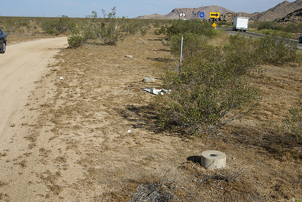
I was able to log three of the four marks. One of the marks in the line of three was a newer benchmark from 1983 and wasn't in the benchmark system at geocaching.com. The other three, arrayed in a triangle shape all dated to 1934, the year after my parents were born. I'm at a loss at this time as to why the National Geodetic Survey wouldn't have that last mark in the database yet. Yet, I encountered another benchmark once I got over to the other virtual flags that wasn't in the system either.
This benchmark, which I found 38 feet away from a hidden cache, was a pipe cap type of benchmark, driven into the ground right on the boundary of Joshua Tree National Park. The mark is dated from 1932, so it's relatively old and I was hoping that it might be in the system, yet when I checked later on, it was not to be found. 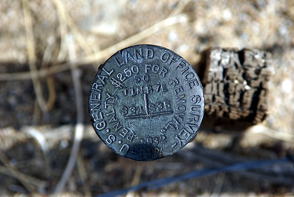
I think I'll keep these photos in a safe place. Who knows? Perhaps in the future, I'll be able to pull them out of the archives and log them when the database gets updated. From past experience, I was pretty sure I'd logged all the ones in my local area, but now it appears as if new ones are showing up in the database. This would indicate that the database does get updated from time to time. Now I just need a way to remember that I have them.
Pictures were taken at or near the following geocaches:
POINT - by Team Christiansen
Architectural Digest - by Joshua Tree Bonnie & Clyde

Thursday, May 28, 2009
More metal disks
Besides the water tank and geocaches, we also found several benchmarks this past weekend. I've written about benchmarks many times in the past, but for new readers, benchmarks are things placed in the landscape that are 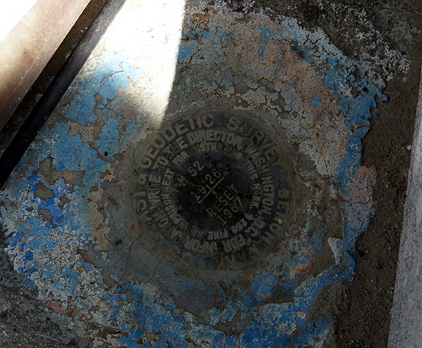
My friend Chaosmanor enjoys hunting benchmarks. He also enjoys submitted reports to help update the benchmark database. As of this post, he has logged 192 benchmarks. He doesn't submit reports for all of them, but I'm sure he's submitted a great many of those 192 benchmarks. My paltry 27 benchmarks pales in comparison. I would like to add when I found we were near some benchmarks, I made it a point to let everyone know that I was interested in finding them, not just get them if we got close. We actually made these 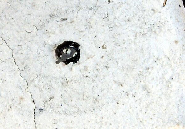
Of the four benchmarks I logged on Saturday, I would say only one was the classic type from the US Coast and Geodetic Survey (USGS). There have been other types of benchmarks added to the database in recent years, so there are now more opportunities to find and log benchmarks. The other benchmarks found on Saturday came in two different types. One was just a nail with a small disk attached to it on the base of a bridge. If you were to go out in your front yard, you might find a similar looking thing along the curb in front of your house. Where I used to live, I had two of them, one on each side of my property. The nails/smallish disks marked the edge of my property line from my neighbor's.
The other type of disks I encountered on Saturday was similar to the classic USGS disk, only they were smaller. One was 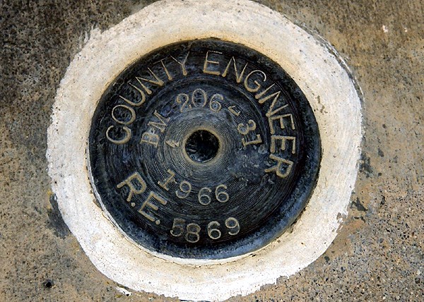
The other disk was attached to an old bridge, much like the classic USGS disk we found earlier in the day. Many old bridges tend to have these benchmarks, mainly because the bridges can be viewed as fairly permanent structures. The bridge where we found the cache and benchmarks had been bypassed by the road that used to travel over it. As cars were whizzing by at 60 mph, we were checking out a cache and nearby benchmark in relative peace, with the exception of the road noise 40 feet away.
The benchmark, which was placed by the Flood Control District, had been painted over. I've actually seen this a lot. One of the first benchmarks I logged has now been painted with red paint 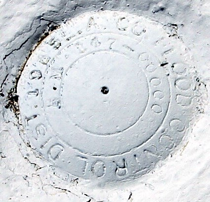
As I continue to explore back roads, I'll probably end up finding more benchmarks. Sometimes, I've even found myself looking at older structures and bridges wondering whether there is a benchmark placed on it. I would suspect with satellites and other technology, that benchmarks, although useful, might not be utilized as much as they were in the past. Probably? Maybe? A lot has changed in my lifetime and who knows if they'll still be used in the future. In any case, I'll continue to look for them when I can. They're sort of a link to bygone days, when everything in life tended to move a little slower.
Pictures were taken at or near the following geocaches:
Bridge, Benchmark and Booty - by Yosemite John and Debbie
Ode to my GPS - by The Long Riders and glh
Bridge, Benchmark and Booty II - by Yosemite John and Debbie

Tuesday, April 21, 2009
All shapes and sizes
While up in Santa Cruz, I attempted to find the cache, Benchmark 941 3745 TIDAL 4. Obviously, a benchmark is located near where the cache was hidden. I could find neither and the cache isn't a micro. Sometimes the geosenses work and sometimes they're on the fritz. The c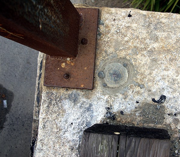
Looking at the picture of the benchmark on the cache page, I'm very surprised that I didn't find it. It seems to be a typical/standard USGS benchmark disk. And yet, not all benchmarks are that kind of standard disk, nor are they all obvious. This one was hidden by leaves, but it must be there, since it has been found at least twice since I visited the area 10 days ago.
After finding the Neary Lagoon virtual on the same walk as the attempt on the benchmark cache, I headed back to the motel and discovered there were two more benchmarks along the Boardwalk. When my son and I went to ride the Giant Dipper later that evening, I didn't take my camera with me, so I figured that I would log them in the morning before we left. Both were easy to find, one being the standard disk located on a piling for a railroad bridge that is near the eastern edge of the boardwalk. There was a walking trail right next to it, so I really wasn't putting myself in any kind of danger by going over and taking a picture or two of the benchmark.
The other benchmark was at the other end of the boardwalk. It was the dome and cupola of the former 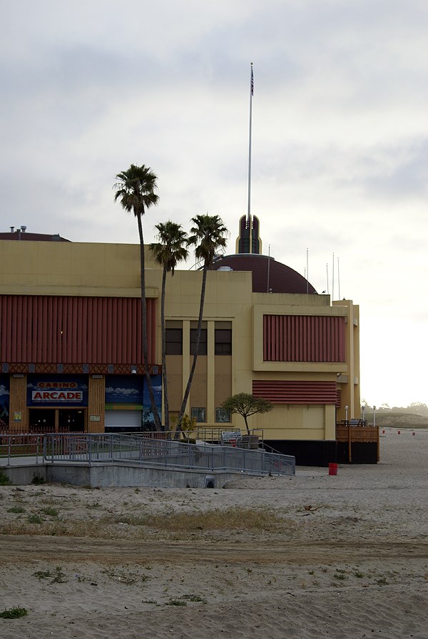
What this means, I guess, is if I want to log benchmarks, then I need to be prepared, because they seem to be all around, in some surprising locations and in some interesting shapes. They also aren't always where you think they might be. As I was thinking about the write up for this blog, I realized that I'd taken a picture of a lighthouse while logging an earthcache in Santa Cruz. Since the lighthouse down at Point Loma in San Diego was a benchmark, it stood to reason that this one might be a benchmark too. A quick scan of the local benchmarks revealed a lighthouse, but not of the one I took a picture. There's another lighthouse just to the southwest of that one and it's the benchmark. I didn't get over there to see that one, or take a picture of it, so it wasn't logged.
As in the past, my primary focus is on geocaching. I happened upon the two benchmarks, mainly because I had wireless connection in the motel room, so I was able to do a quick search for them. Most of the others that I've come across, have just been happenstance. But I think I need to at least scout out locations where I know I'm going, just in case an interesting one might show up.
That same weekend, while we were driving by my daughter's school, I saw something out of the corner of my eye, that looked suspiciously 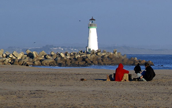
Pictures were taken at or near the following geocaches and benchmarks:
GU1944
GU4080
Seabright Beach Building - by TerryDad2 dedicated to 50sumtin

Sunday, January 25, 2009
Hidden weekend
Part of the game of geocaching is hiding caches. If no one were to hide any caches, how would anyone find any? As noted in this post from earlier in the month, I had several caches 
About 2 miles north of my house is a large plot of land known locally as Johnson's Pasture which was purchased by the city to remain open space for the enjoyment of everyone in the city. It is adjacent to the Claremont Wilderness Park which abuts the pasture to the east. There are a series of fire roads which can be used as walking trails through both parks. Inside the wilderness park is a five mile loop trail that is quite strenuous and used quite frequently. There are side spur fire roads leading from Johnson's Pasture over to the wilderness park. There is not loop within Johnson's Pasture, but when geocaching friends come to visit, we usually end up taking two cars and creating a shuttle. We park over by the wilderness park, then drive everyone over to the Johnson's Pasture area and then hike from there over and down to the parking lot at the wilderness park. It's about a five and half mil
Most of the caches up in these two parks were hidden by me. I enjoy roaming around the two areas and whenever I feel the need to hide a cache, that's usually where I end up going first. This weekend was not exception. The Tadpole and I loaded up our backpacks with four caches, took our GPSrs and hit the trail. As long as we were up there, we might as well find some of the caches that my son hadn't found yet. He found the first one as we entered into Johnson's Pasture. Then we hiked up to a mystery cache of mine to do a maintenance check on it. After the Tadpole found that one, we tried to find a spot in between these two caches that would work, but they were too close together to hide another one, so we moved on to where I wanted to hide the cache the Cheeseheads sent to me at Christmas.
There is a microwave tower that dominates this area, since it's on one of the high hills in the two parks. It serves as a benchmark for surveyors as well and I thought it would make an excellent spot for a cache hide. We hiked up there and found several spots where a nice sized cache could be hidden. Once we chose the site, we got coordinates for it and then started back down. As we had been hiking up, we'd been taking coordinate readings for a letterbox cache that I wanted to hide up here, but couldn't find a good spot. I may have to look along another trail for a spot to hide that one. But on our way down, we found a perfect spot for a small decon container and hid that one as well.
We'd also been working on a multi-cache. I had already scouted out the final location. That wasn't a problem, but we needed to check out possible sites for the first stage of the multi. Once we agreed on a good spot for the first part it was time to make our way back home. We came back the next day to take some final readings for the multi-cache as well as tak
The first two, Melted Cheese and Rusted Gate have already been approved and I would expect the third, Exploring the Technology to be approved sometime this week. That will bring me up to 25 hides. The Tadpole and I also discussed how we should list these. We agreed that we should list them under my geocaching account, but we should come up with some kind of name that would let people know that it was both of us that worked out the hide. We both like what we decided as a moniker for the two of us.
Pictures were taken at or near the following caches:
Melted Cheese - by The Swamp Things
Rusted Gate - by The Swamp Things
Exploring the Technology - by The Swamp Things

Sunday, January 11, 2009
Changing perceptions
Back in June, I wrote about finding a benchmark in a vertical fashion, attached to the wall of a bank. Now before that time, I was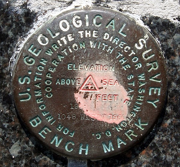
Well, it's starting to make sense now. Placing a benchmark disk on the side of a building, is placing it on a structure that's probably not going to go anywhere, although there could be some doubt about doing that extensively in Southern California due to earthquake activity. There's at least three that I've found recently that are on the sides of buildings, so it must be more prevalent than I previously had thought. And it does make a lot of sense now that I look at some benchmark pages with this kind of placement. The settings for the benchmark are listed as "massive structures with deep foundations" and the stability of the 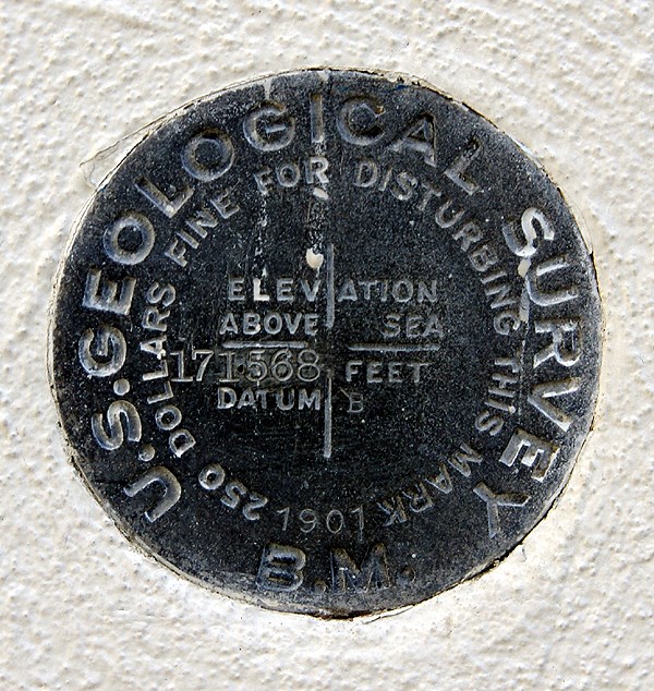
The one that I found on Saturday was one of those serendipitous finds that I just happened to stumble upon. I had been out caching with my friend 3blackcats in Azusa (the town that has everything from A to Z in the USA) and we had just finished up our day of caching. We had already passed the benchmark once heading to the cache and were making our way back to our car when I noticed this nice benchmark at chest level stuck in the side of a Wells Fargo bank building. Since it was labeled a US Geodetic benchmark, I knew instantly that it would be in the benchmark system at geocaching, so I had 3blackcats take two pictures of it for me with her Blackberry. She sent them to my via email from her phone (geez, you have to love what our technology can do today) and I logged the benchmark later on that afternoon. It was my 20th benchmark logged.
Not noticing the benchmark on the first pass by, to me is really inexcusable since it's right there. I saw it right away coming back, but I can use as an excuse that I wasn't paying attention to my GPSr or looking out ahead to see if I could figure out where the cache could be placed while we got to the cache area. I can
But, I also go back and forth over this all the time in my mind. I went through a period of time several years ago where I was actively seeking benchmarks. Now, if I'm in an area, I'll check out likely structures or areas where there might be benchmarks, but I haven't really gone out of my way to seek them out. The sudden finds, like this one on Saturday seem to be the most fun for me right now. That could change over time. The one thing that I want to continue to do is take a picture of each benchmark that I log. I don't understand why people would log a benchmark if they haven't taken a picture of it.
Pictures were taken at the following benchmarks:
EV9089 - San Bernardino City Anderson Building
HS1151 - Merced County Courthouse
EV2527 - Wells Fargo Bank Building - Azusa

Tuesday, December 9, 2008
Benchmark Bonanza
Last Saturday dawned amazingly brilliant which was fortunate because the Tadpole and I had plans to head out to the desert for some geocaching. 
We continued up Old Woman Springs Road which runs in a northwesterly and then westerly direction up to Victorville, CA. This road runs nearly over the epicenter of the June 1992, 7.4 Landers earthquake. I'd been out to this site a couple of times, even stood at the epicenter looking at a 6 foot high escarpment that hadn't been there before the earthquake. At a cache looking down a road that crossed the major fault that ruptured, 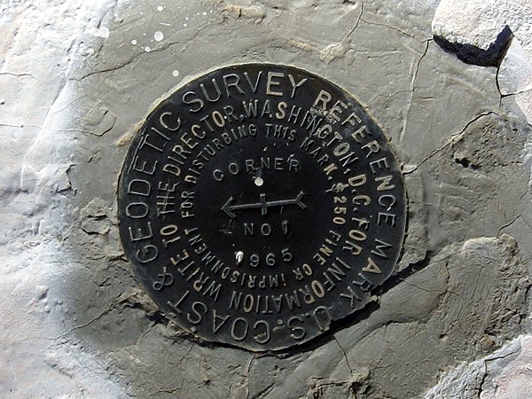
Continuing our drive west, we stopped at a geocache alongside the road and were awarded with an unexpected bonus....Benchmarks! The Tadpole had gotten out of the car and walked closer to the cache site and I hear him exclaim, "Whoa Dad! There are a couple of benchmarks out here." Sure enough, we found several nice disks embedded into the rock. Then we round another disk and another and another. Eventually, we counted five disks, which led to three or four benchmarks, depending upon 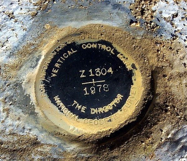
Needless to say, I had to go back to the car to take pictures. It was then, after getting the camera that I looked at my PDA for the cache listing and realized that I should have already know about these benchmarks, since the name of the cache were were trying to find was called, 5 Benchmarks TB Hotel. Well, Doh!
I first wrote about benchmarks back in January when this blog was relatively new. Since learning about geocaching, I've logged 19 benchmarks, of which 14 have been logged since last June. I'm not sure what to make of this. Either I've become more aware of benchmarks, or I'm getting out on the trail more in this past year, which will get me out to spots where benchmarks tend to be more prevalent. 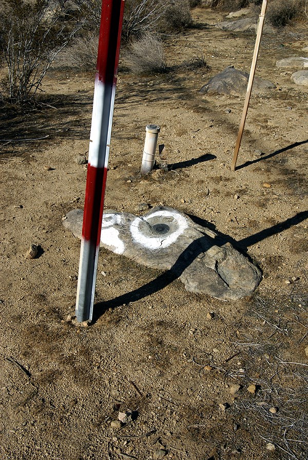
When all the pictures of the different disks had been taken, we eventually looked for the cache. The tadpole has taken a new leap in his cache finding ability and was the one who found this cache. He beat me to quite a few caches this day, but I think this one was the hardest find, where he just out hustled me, getting into the nooks and crannies of the rocks to finally scope it out. He was very proud of himself.
When I said there were three or four benchmarks, depending upon how you counted I wasn't kidding either. The cache is called 5 Benchmarks, because there are five embedded disks located in the general area. One disk has two reference points, both other disks that actually point to the benchmark. These would be the ones that are labeled Corner on them. Then there was a two foot tall metal pipe with a benchmark on the top of that one, plus one other one with so many identifying letters and numbers it was difficult to keep them all straight.
Interestingly, this particular benchmark is actually listed twice in the benchmark system, labeled as two different benchmarks, yet they both identify the same benchmark. 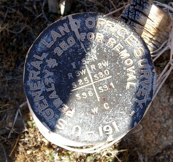
Pictures were taken at or near the following geocache:
5 Benchmarks TB Hotel - by Team Christiansen

Sunday, October 12, 2008
Forgotten Trail?
Yesterday, Chaosmanor and I hiked a loop trail in the Ronald W. Caspers Wilderness Park just north of San Juan Capistrano. It's a very large park and we were there primarily to get a dashpoint that had been positioned by the GPS Games computers near the north end of a couple of trails. 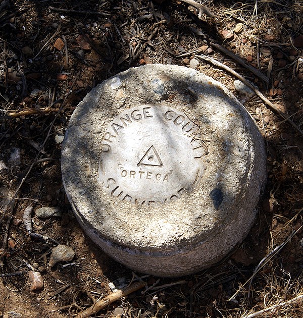
The trail we'd chosen to get to the dashpoint was called the Eastridge trail. It was a short hike up from what was called the Quail Run trail up to the Eastridge trail. We have views to the east of the Ortega Hwy and the valley that made up most of the park to the west of the ridge. Interestingly, there was only one geocache that we noticed along this trail. As we made our way over to this cache, we spotted a benchmark, or actually Chaosmanor spotted a reference post noting a benchmark, which was very close. The trail actually had a paint mark on the ground pointing to the benchmark.
This was one of those spontaneous finds. We hadn't really looked at the possibilities of there being benchmarks along this trail and we just happened to find this one. When I got home I was pleasantly surprised to see it in the Geocaching system. We took our requistite pictures of the dashpoint and then made our 60 foot walk down to where the geocache was supposed to be.
After about 10 minutes of searching, we consulted our PDAs and found the cache to have been DNFed back in November of 2007 and not found since before March 2007. Ground zero yielded a rather large packrat's nest, but nothing that looked like a decon container. We eventually expanded our range out thirty and forty feet, but couldn't come up with the cache. I posted a DNF last night and within minutes, the cache was archived. I think had we know the cache had some possible issues, we might have taken another route, but then we wouldn't have found that benchmark, nor the o
We started making our way north along the Eastridge trail commenting about the lack of caches along the trail. Chaosmanor brought a small container that we used down the trail to hide one cache, but there could have been quite a few nice caches hidden along this trail without even getting close to the cache saturation level. It's almost as if this trail had been forgotten by the locals here. Either that, or they're still working on it. I prefer the latter approach because you could say the same thing about the Claremont Wilderness Park near my house. There are still some great areas for caches, but I haven't gotten around to it yet. Eventually, as I'm sure the locals down there will do the same over time. It was just surprising to see this long trail with only one cache on it.
After Chaosmanor hid his cache and we checked (beta-tested) his coordinates, we continued along the ridge toward its northern terminus. At the junction of two trails at the north end we found another benchmark and a nice reference post pointing to the benchmark. We took our pictures of this benchmark, marveled at the nice view and noticed a game trail leading beyond the two trails, where it looked like another decent cache could be hidden.
The hike back down to the car netted us 5 well done larger caches, one very well cammoed that the Tadpole got to first. He was pretty proud of himself with that find because it was well hidden in plain site. Back at the car, the GPSr's internal odometer showed us we'd hiked 5.46 miles. It gave us a good workout as my calves will attest to this morning. Five caches found, two benchmarks logged, one dashpoint scored and a good hike with friends and family made it a very good day, one of those geocaching days that will stay with me for a long time.

