This past week, I went on a short road trip to Northern California. I know short is a relative term, but it was short for me in time, as opposed to distance since I put slightly over 1000 miles on the van, plus added two new front tires during the trip.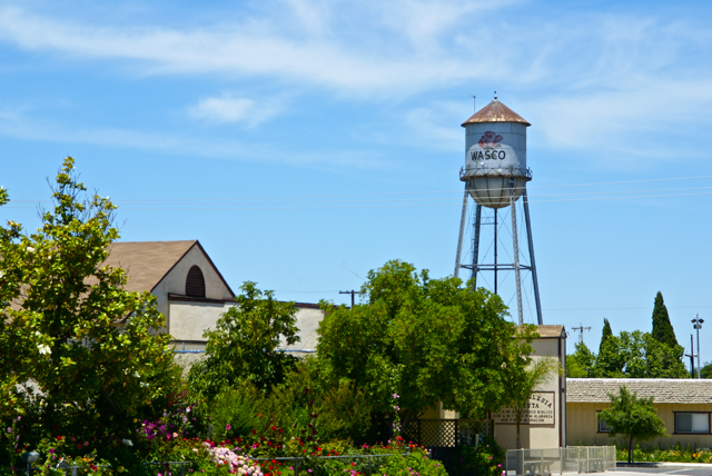
I drove up to Stockton, mainly to deliver extra "stuff" to my daughter, including a couch that she'd gotten from her grandmother, but couldn't fit in her car. There would be a side trip to Santa Cruz to pick up my son as well. Since he wanted to visit with his sister for a little bit, I picked him up, then drove back over to Stockton. This should have been a 4 hour round trip, but it ended up being over 8 hours because a problem developed on one of the front tires and I had to get that fixed before we could head back. Things happen and there's not much I could do about that.
Each time I drive up there, I try to take different routes. I look at the different virtual flags that can be captured, as well as any possible dashpoints, plus geocaches and then I plan my route accordingly. Waymarks and benchmarks are side possibilities, but for those, I just let them happen as opposed to me actively search for them.
If you've followed this blog for any length of time, you know that my most active waymark category is water towers. I love driving into small towns and seeing their town advertised for miles by the large water tower in the center of town. We have few water towers in Southern California, as most municipalities build large storage tanks in the hills above town which provides the same purpose of creating water pressure for the town's water supply.
Towns in the Central Valley of California and elsewhere where no hills are present create their town's water pressure by building water towers. Usually, these water towers promote the city, but some support advertisements for local businesses. The main water tower in Merced, California promotes the newest university in the UC system, UC Merced.
As I drove through the Central Valley this week, I happened to drive through the town of Wasco, CA. I've seen signs pointing to Wasco while driving both Hwy 99 and I-5, but have never gotten off, mainly because the town is out of the way. 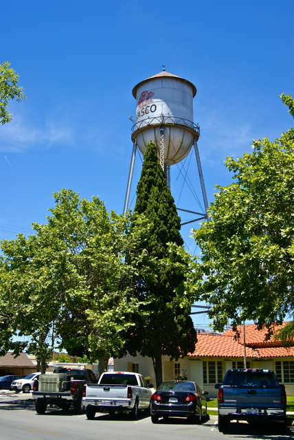
Had I known a little bit about the town, I might have been tempted to stop there sooner. Wasco bills itself as the Rose Capital of the World. Every year it has a rose festival the weekend after Labor Day weekend and the water tower in the middle of town is plastered with a large red rose. After getting home, I discovered that 55% of all roses grown in the United States are grown in and around Wasco by nine major rose companies. It was a pleasant experience to drive through the fields around town and see rows and rows of red roses, then rows of yellow roses. I know I've never seen so many roses in one place before.
If not for the GPS games that I play, I probably would have never passed through this quaint little town. I feel, I'm richer in spirit because of this hobby. If you happen to be in the area on the weekend after Labor Day some year, I think you could do worse than to make a stop in Wasco and take in their Rose Festival.
Pictures taken at the Wasco Water Tower:
Saturday, June 12, 2010
A rose by any other name...

Monday, May 25, 2009
Geocaching and waymarking
This past Saturday, I was able to get out for the first time in a week to do some geocaching. The Tadpole and I met up with Chaosmanor near Hollywood to do some GeoVexilla and some geocaching up north of 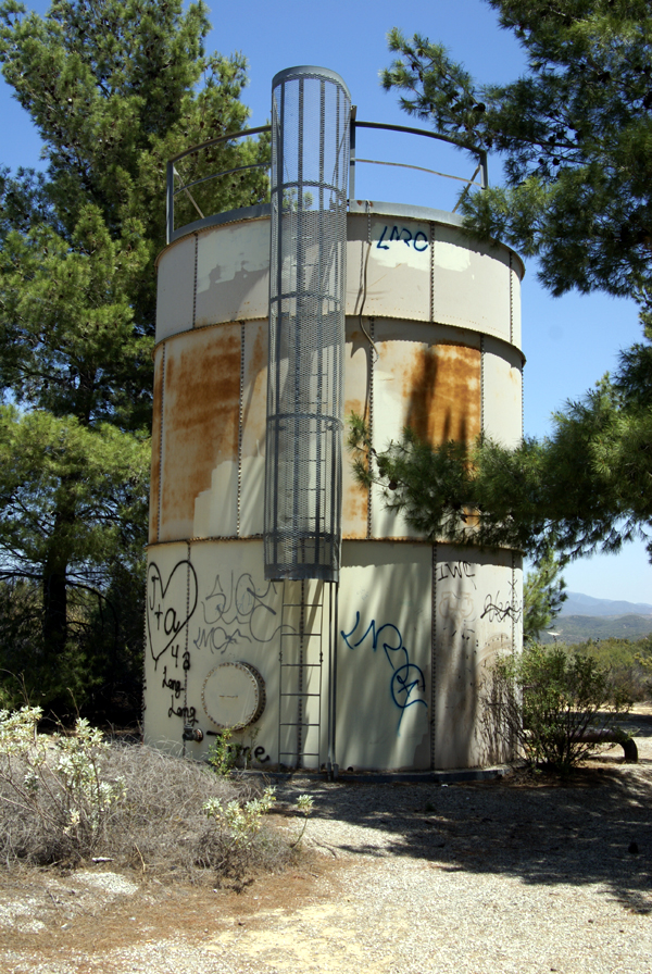
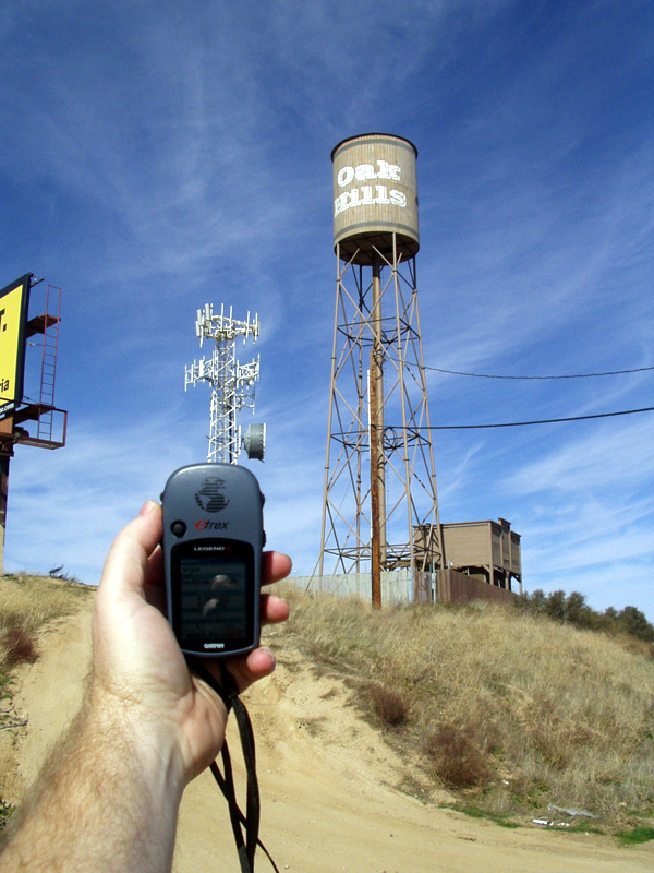
Along the trail, on a ridge overlooking the lake, we came upon an old water tank. I'm not sure what area or town was being serviced by this tank, but it was clear that this tank had seen better days. As you can see by the picture, the tank has been struck by graffiti numerous times. Surprisingly, there wasn't a lot of trash in the area, probably because the narrow road leading up to the tank and beyond had a locked gate on it. Too often, less populated area tend to become dumping grounds for people that either can't afford the fee to take their trash to the dump, or don't want to be bothered. Places, that could be very beautiful, become blighted in the process. At least this hadn't happened here outside of the graffiti.
The tank was situated in a copse of pine trees. The trees were obviously planted to obscure the tank, making it less of a public nuisance. I decided I'd waymark this tank, since the water tower category is one of my interests at Waymarking.com. We continued our hike beyond the tank and came to the cache we'd set our sights on earlier in the day. This particular cache gave us a lot of trouble because it was well hidden. My GPSr kept telling me I was at ground zero in the middle of the trail, only about 6 feet away from the cache, yet I never did spot it. All three of us probably walked right by it several times. Eventually, Chaosmanor spotted a small portion of the lid of a decon container peeking out and we had the find. The view from 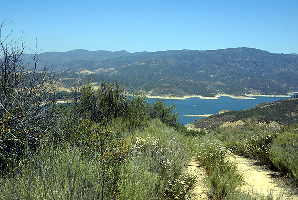
After finding that cache, we headed down below our parking area to another cache. This particular cache had been hidden west of a former picnic area overlooking Lake Castaic. Unfortunately, the area had been closed for some time. The road down was in disrepair and the picnic area were overgrown with weeds. The two bathrooms had been totally trashed and it was evident that the local graffiti artists had been at work on several of the structures.
We would have actually missed most of this had we paid better attention to our geosenses and GPSrs. At one point, we had the opportunity to either stay on the road, or take an overgrown trail. It looked like the road was going to take us to the same place, so I opted for that route, since the main overgrowth on the trail was foxtails. Anyone who knows me very well knows that I detest foxtails. In reality, we encountered foxtails all day long so it really wouldn't have made much of a difference and had we taken that particular trail, we would have avoided all of the graffitied buildings, etc. that we passed on the hike.
Eventually, we ended up out on a point overlooking the lake. The GPSrs were pointing us in a variety of directions, but we didn't have much room to maneuver around because the trail became, in Tadpole's words, "Uber steep." and would have become treacherous had we continued, so I figured 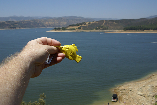
The hike back up was strenuous, but we made it up without too much difficulty. In a couple of months, the trail will be very difficult because of the summer heat. There was little to no shade. Hopefully, someone else will be down there to pick up the travel bug, otherwise it might stay there awhile. All in all, it was a good day. But then again, when I go out caching with the Tadpole and/or Chaosmanor it usually ends up being a good day.
Pictures were taken at or near the following geocaches:
Lake View Cache-taic - by Team Magpie
Below the Castaic Overlook - by Don J

Saturday, July 12, 2008
Stuff Happens
Sometimes when you're out caching, nothing happens you have a great time and everything is good when you get home. 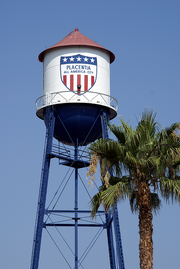
I took my younger son out to play with the GPSr today. The first thing we did was capture the flag of Bermuda. I wasn't sure whether it was actually going to happen or not, since I'd pretty much realized before we went that the flag was going to be behind a gate, but I figured that we'd get close enough that we'd score the point, which we did. We also waymarked a water tower today. I've mentioned that particular water tower at the bottom of this post, and we finally were able to get back to get it today.
The caching was fun. There was a neat puzzle that I'd solved about a year ago that I finally got around to finding. The rest were small caches, a couple of which had geocoins in them, another was large enough to place a travel bug in. But what happened to me at some of the caches makes me wonder whether I just should have stayed home. Let's see, let me count the injuries.
Injury one happened when I didn't heed the warning on the cache page. The warning stated,
"A note of warning, it seems many people are getting whacked on the head with this cache so please be carefull (sic) and watch your noggin."
Now, my thought process was that the cache could fall on you. I really didn't have a clue other than that until about 15 seconds after 
Two caches later I bumped my head looking for a cache under a bridge. After I came up for air, I noticed that the GPSr was now pointing 40 feet away from where I'd been looking under the bridge. Yep, that's where it was, but now I had matching bruises on each side of my head. The very next cache, although there was a good amount of time in between the two since we'd made a stop for lunch, I ended up slipping on a slope of grass and landed on my rear, rather unceremoniously. I have to give my son credit. 
Two caches later, in a parking lot no less, I apparently brushed my hand up against some stinging nettles. Now I've touched stinging nettles in the past and they really do sting. This felt exactly like it, but it was really in an odd place, in a parking lot, on one of the many landscaped islands that you can find in any local Big Box parking lot. Very strange, but over three hours later and my finger was still feeling the effects of it.
Fortunately, that cache was the last cache of the day, otherwise who knows where I'd be if I'd continued caching today, perhaps in traction? I guess this is more of a public service announcement more than anything. Injuries do happen. The slip could have been avoided, the head bumps as well. The stinging nettles was unexpected, but at least to protect myself in the future I need to remember to use glove whenever I'm working around plants of unknown origin. There's a lot worse things out there than just stinging nettles.
Pictures were taken at the following waymark:
Placentia Water Tower - by Webfoot

Wednesday, March 12, 2008
A Different Kind of Locationless Cache
I went caching last Saturday down in the O.C. My daughter was coming home from college and was going to be dropped off in


