In November, Los Angeles gets treated to the annual U.C.L.A./U.S.C. football game. An old saying I've heard in the past was, "On a clear day, U.C.L.A. . . . . . . . . on any other day, U.S.C. Obviously, this one was created by a Trojan fan, but if this past week is any indication, U.S.C. might be in trouble this year. 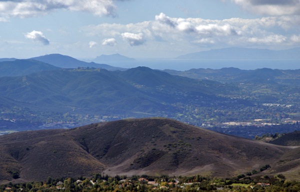
Last Saturday, I went on a hike with my friend Chaosmanor in the Agoura Hills area of the Los Angeles Basin. We'd planned a trip to get us several geocaches, plus a virtual flag that would score me the maximum number of points in the game. We found several caches before heading up to the trailhead to begin our hike.
The first part of the hike was on a new trail open for about a year or so. Surprisingly, it had no caches on the trail, so Chaosmanor took it upon himself to hide a couple while on our way. Soon after those hides, we were on a fire road heading up to some caches that hadn't been found in exactly a year. Well, they still haven't been found. One cache we started to attempt, but didn't finish, mainly because the terrain had changed slightly in the past year. There was a lot of plant growth, which concealed the main way up to the cache and any other route that we could see, looked extremely treacherous and so we passed on it.
The second cache was similar, so we didn't even make an attempt to get up to it. The third cache was attempted after a nice lunch at the end of the fire road on which we'd hiked. This one was probably the most frustrating of the three since we were able to hike up to the cache site and do a very thorough search of the area. After calling a lifeline, we were pretty much able to verify where the cache probably had been, but we couldn't find the ammo can that had been placed there. 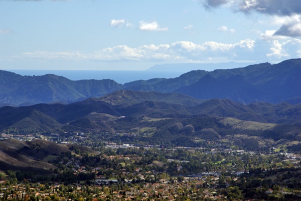
After striking out there, we headed further up along a game trail and found another more established trail that took us up to the virtual flag and a couple of other caches, including a virtual cache at the top of Simi Peak, just inside the Santa Monica Mountains National Recreation Area. This stop was probably the highlight of the day.
The peak is only 2403 above sea level. I was able to verify that with a laminated sheet at the peak. I put my GPSr down next to the sheet and eventually, it also read the same elevation above sea level. Just after I took the picture, the elevation on my GPSr changed again. I've noticed that on other occasions as well, so I'm not ready to say that my GPSr has great accuracy when it comes to elevation, just that I was able to get the two numbers to coincide.
That didn't make the highlight reel though. What made this spot truly noteworthy was the view. Even though we were at fairly low altitude, we had a complete 360˚ view which stretched for miles and miles, literally. Originally, I had been looking to the west from the peak. Chaosmanor had already pointed out the ocean from further down, but once we got on top of the peak, we spotted Anacapa Island and behind it, Santa Cruz Island, both within Channel Islands National Park. Looking at the map, it looks like we were at least 30 miles, probably more distant from those two islands.
Then we got a bigger shock, I believe, when we looked south and could see the ocean and Catalina Island in the distance. 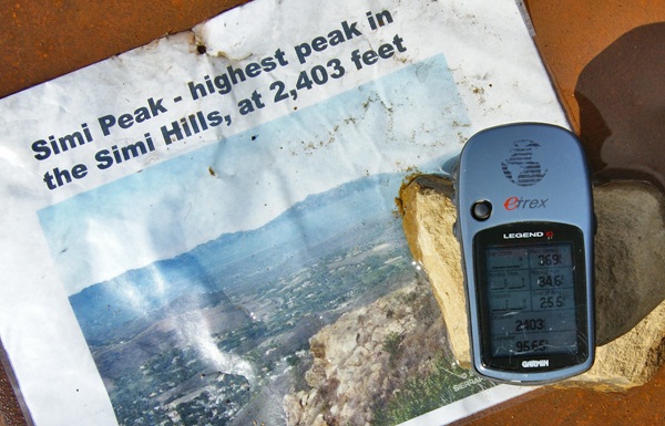
The weather conditions were just right that day where we were. Other hikers might not be so fortunate, but hopefully, that won't stop them from coming up there. I can imagine that peak in fog. That would give an entirely different perspective to the area, that's for sure. We spent a great deal of time up there, getting the necessary information to fulfill the requirements, take pictures of the scenery, take pictures of the benchmark that's also at the top and also just to enjoy the view. It's not often that the Los Angeles area is that clear. Besides the ocean views, we also had amazing views of Simi Valley to the north and the San Fernando Valley to the east. It was a picture perfect day.
Eventually, we knew we'd have to descend back into civilization and we did it reluctantly. We hiked down the trail heading to other geocaches further down the slopes of Simi Peak. At one point we missed a trail junction and ended up further north than we had originally anticipated being, so that added another mile or so to our overall hike, but it was definitely worth the effort. It had been a good climb up and a good hike totally just over 8 miles. It had been a good day.
Pictures were taken at or near the following geocache:
Simi Peak Returns - by WM6P
Friday, November 5, 2010
On a clear day...

Thursday, June 3, 2010
Where is that thing?
Every now and then, I will come upon a cache that I feel is just well done. That was the case last weekend with East Canyon Log-In. The coordinates were slightly off on this particular cache, but being thirty to fifty feet off in a rural setting is a lot different in many ways to being the same distance off in an urban setting. 
What helps is the cache page write up, which is one of the reasons I really liked this particular cache. If you go to the cache page, you'll notice that I've placed it on my top 5% list. Making my list in no way implies that the cache is a great cache. It only means, that in some small way, it either tickled my fancy, or I felt it was creative in some way. This one, I think, did both.
The cache itself, is a small jar, which would be difficult to spot in thigh high foxtails and thistles. However, the cache page write is very much like a decrypted hint in helping the finder find the cache. I'm not saying that's necessary all the time, but it sure is helpful, especially when you have tree cover that reduces the accuracy of the GPSr in your hand.
The second part of this cache that I really liked was the cache container. As stated is was a small jar, but what way the jar was incorporated with the surrounding environment helped get this cache onto my list. I actually would have wanted to be a fly on the nearest tree when the cache hiders brought this cache here. I think it would have been very entertaining.
The only other question I have is, where do you think the cache is hidden? It might be obvious, or it might not be.
On a side note. Some of you might have noticed that I've gone to moderated comments. I have done that because recently, I have been getting spam comments. Obviously, the person who has been doing this hasn't gotten the message and continues to post links to pages that I would find objectionable if my youngest were to click on them. Since he reads this column from time to time, I felt it necessary to go to moderated comments. To that person - if you continue to reply to this blog with links to semi-pornographic sites with no other intent other than to generate traffic to your own site, your posts will continue to be summarily rejected. I apologize to my other readers for this action, but I feel it is necessary to keep this a family friendly blog.
Picture was taken near East Canyon Log-In - by BearandDirtybird

Monday, April 12, 2010
Old caches
Today, I was looking at my profile and some of the stats that I have posted there. I don't expect many people to look at it. I keep the stats there mainly as a convenient way of looking over things that I want to keep track of in certain areas. 
Interestingly, I think almost 75% of the caches in this list are still around. That's a pretty good record, in my opinion for 9 year old caches. Of the caches listed above, there's only one that's not in California (West of Work #4), which is to be expected since most of my caching happens in California. Only six of the caches on that list were placed before I started geocaching. I'm wondering whether I'll be able to find some that predate Wilderness Park Cache, the first cache on the list and also the oldest cache I've ever found.
My first cache was hidden about two weeks after the Manzanar Virtual Cache was hidden and it's still out there as well. It gets about two or three finds a year, mainly because it's in a rather remote area up in the mountains. Most of my caches are like that, requiring a hike to get to and so they don't get many finds.

Sunday, March 28, 2010
Old School
Yesterday, Chaosmanor and I found an "Old School" cache. We found a rather longish trail that started in Topanga Canyon near Malibu. In the link, our caching trip started with the cache right near Topanga Canyon Blvd., went east, then south paralleling Topanga Canyon Blvd. 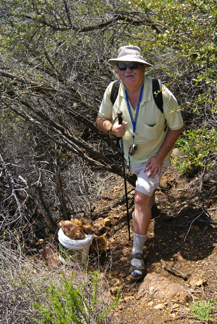
We found a variety of different sized caches from hidden bison tube micros to full scale ammo cans. The variety of the caches is what makes any kind of trail like this very interesting, although this one didn't need many caches to keep it interesting. Hiking along the ridge above Topanga Canyon afforded us with views of Los Angeles, as well as Santa Monica and the Pacific Ocean. It was a good hike.
Now, get out your flux capacitor, get it up to 88 miles per hour and go back in time to December 2001. At that time, there was one cache along that entire trail. But that's the way it was back then. You hiked in, usually several miles in the process, you found one cache, and then you hiked back out.
My very first cache find was a large 5 gallon bucket painted black. Most of the cache containers were like that. They usually contained log books, real log books with large pages where one could write down what they had experienced during the hike. Usually, the view was decent to good and you sat, perhaps ate your sack lunch and contemplated the day. Geocaching was like that.
As Chaosmanor and I walked along, we realized that we had an older cache situated along the trail. In fact, he'd tried to get it four years ago, but had missed an important side trail and wasn't able to find it at that time. Coming at it from the north, we had a do or die decision to make. There was a trail leading up to the ridge where we knew the cache to be. Should we take it, or continue on and try to find a back door to this cache?
We chose the back door route and as we walked along the fire road, we realized we might have made a mistake as we kept getting closer and closer. My GPSr, at one point, read only 235 feet away. However, there was probably 75 to 100 feet of vertical elevation to deal with as well. As we started to go away from the cache, we looked ahead and realized the fire road went around a bend up ahead and it was there that we found the access trail that led up to The Pit Stop.
The trail walked along a ridge with plenty of vertical drop off on both sides. 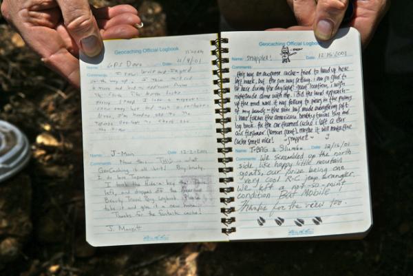
I went one way and Chaosmanor went the other and he ended up finding the cache first. Being in that remote of an area, it didn't really need any camouflage and as you can see from the pictures, it didn't. The log book didn't disappoint either. Full pages, complete with full descriptions of experiences in the beginning, diminishing down to single line entries in the later years, or perhaps just signatures.
We spotted some old time cachers from the Southern California area, names that everyone knew because there were so few of us back then that we would literally follow each other to new caches every weekend. I recognized names, such as gpsdave, sr.hikers, erik, and PezCachers. Of those four, only PezCachers do I predate as far as geocaching longevity. Erik has been geocaching since October 2000, sr.hikers since February 2001. Gpsdave signed up two days before me in March 2001. All appear to be still active in geocaching, based upon activity on their profiles.
Chaosmanor and I spent much more time here than we did at some of the other caches we found on Saturday. 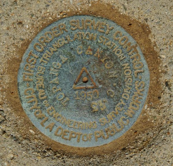
There was no doubt that this cache would make my top 5% list. I also decided to use this one as my qualifying cache for the LA County Quadrangle Challenge cache. I only need 10 more quadrangles to qualify for that cache. I suspect that I will be doing some more hiking, particularly in the fall when it cools down, to get some of the rest of those quadrangles. Most of the ones I have left are fairly remote and will require some hiking to get.
At the end of the day, both of us were extremely tired. Looking at a trail map, it looks like we walked about 6 miles. I would suspect that it was over 7, because many of the caches were not placed directly on the trail. Many you had to hike off the trail quite a ways to get to the cache. The Pit Stop was an extra .15 mile each way off of the main trail. That doesn't seem like much, but add a quarter mile to half a dozen caches and you have an extra mile and a half. That's OK. We were doing some Old School caching yesterday.
Pictures were taken at or near the following geocache:
The Pit Stop - by DahMooser and MsPea

Wednesday, February 3, 2010
Out of this world and other things
I thought I'd seen everything, but this has to be the hardest cache ever to find, especially since it's several hundred miles above the Earth's surface. Richard Garriott, one of the astronauts that have been on the International Space Station (ISS), hid a geocache in one of the lockers on the ISS. Not that I have enough money to buy my way on to one of the space tourism rockets planning on heading there probably in the next decade, but that would be a very cool cache to find.
In other news, Jeremy, the founder of Groundspeak, which runs geocaching.com tweeted about a travel bug rescue site that has started up recently. Here's the video posted to the front page of the travel bug rescue site.
I checked out the map on the site and discovered two travel bugs that are in need of rescuing near me. Near me is relative since they are both about 100 miles away from me. I've bookmarked the page for future reference. The likelihood that we could get close to rescue a travel bug would probably go up during the summer months when we're planning our camping trips.
The one cache near San Diego looks like it either got muggled or washed away. Reading the logs on that particular cache page indicates that the travel bug in question (Hoofy) isn't in the cache anymore. It's still an interesting concept that could work as the site grows.

Wednesday, December 2, 2009
Monarch's Rest

Because we were headed towards Cambria, along California's central coast, we would be traveling along either the 101 or Hwy 1 depending upon where we were going to be in any particular segment. We'd been traveling along the 101 for awhile and were headed over to Pismo State Beach which fronts along Hwy 1, sort of where the two roads join up. Pismo State Beach is one of the major wintering grounds for the Monarch butterflies. What better spot for the Monarch's to rest than along the El Camino Real, The King's Highway.
There's a virtual cache at the spot that you're only supposed to be able to log during the winter months because that's when the Monarchs are there. 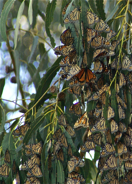
When we got there, there was an interpretive session going on by one of the docents, but we chose to wander the paths, to discover the Monarchs all by ourselves. Immediately, we spotted one sitting by itself on a eucalyptus tree. As we walked, I could see one flying through the trees, but we weren't seeing a large clusters that I'd heard about so I was a little disappointed. I'd seen a Monarch once in Kings Canyon National Park, but I was hoping to see some of the wintering behavior.
As we hiked along the backside trail, we didn't see anything other butterflies, so we decided to go back up and walk along the main trail. Both of us enjoyed the solitude of the lower trail as there weren't any other people along that trail. And for good reason because we realized our error as soon as we got up to the main trail where the multitudes of other people were. Hundreds upon hundreds of butterflies were clustered in the eucalyptus trees.
I think what was really impressive about the display was not the butterflies, but the quietness of the people in the grove. It was almost like they were entering a shrine or church of some kind. Even small children, upon seeing the butterflies, opened their mouths in wonder, but there wasn't a lot of the screaming and inconsiderate behavior that we commonly find in other areas where it really should be quieter. It was refreshing to see and hear.
Geocaching continues to bring me to these kinds of places, places that I either didn't know about, or were possibly off the beaten track where I would normally go. 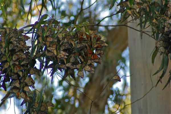
Pictures were taken at or near the following geocache:
Monarch's Rest - by Jon & Miki (Adopted by Scooterman)

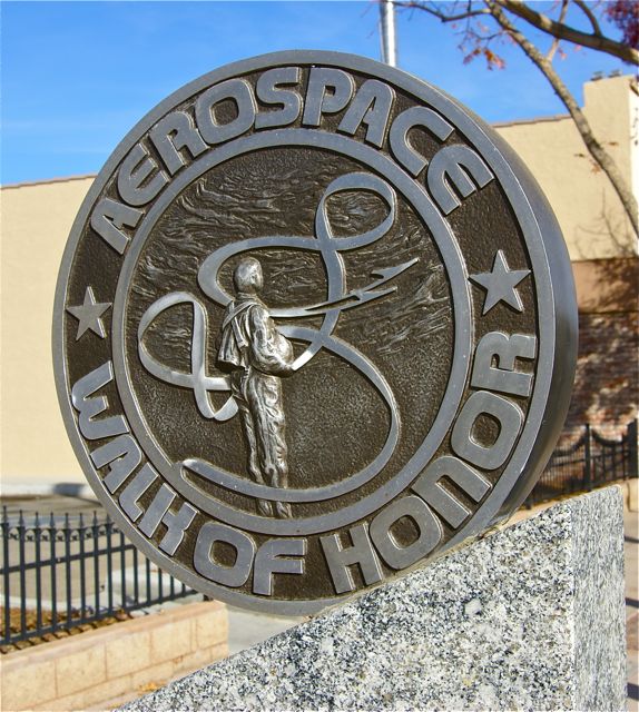
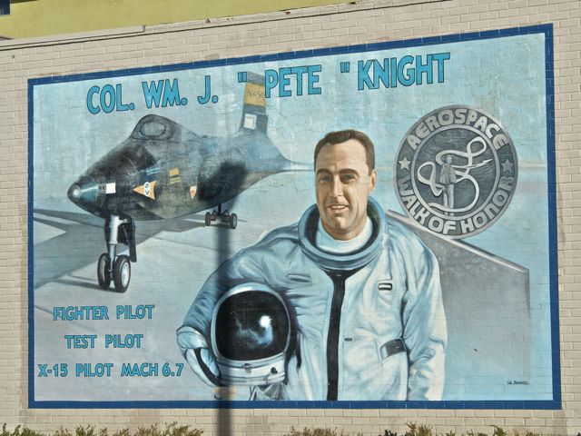
Sunday, November 22, 2009
Walk of Honor
I'd been here three years ago in the exact same spot with some other caching friends of mine. It was August and I remember it being hot, but that didn't stop us from enjoying the day. We solved a mystery cache involving the Lancaster Public Library and found that cache. One of the stops on the virtual we found yesterday is right outside the library entrance. I'm at a loss as to why we didn't do this virtual back then, but for some strange reason, we didn't.
In actuality, that worked out for the good, since I was able to take my astronomy loving son up here where he could learn about some of the pioneers in the aviation industry as well as the early pioneers of NASA, probably before it was even called NASA. Monuments to different pioneers line Lancaster Blvd. on both sides of the street, with information about various people who were instrumental in the testing of different aircraft. Neil Armstrong was highlighted, as was Fred Haise one of the astronauts on Apollo 13. Chuck Yeager and Jimmy Doolittle were both highlighted with monuments and murals on the sides of buildings along the street.

The cache needed 7 specific bits of information. After we'd walked the entire route, on both sides of the street, we realized that we missed the first bit of information. Based upon where we'd found the other bits of information, we figured where that information should have been, so we walked back down there to check out the monuments again.
I told the Tadpole that we needed to be systematic on our approach to this one, so we started on one side and read through each monument. It didn't take long to get the correct information this time. We found it on the pilot who had the same last name as us. We'd been both so interested in thinking about that aspect of the pilot, that we hadn't looked close enough at the rest of the information on the monument. Needless to say, we got a good laugh out of that.
There was a bonus in all of this as well. Because of our trip to get that last bit of information, we took a slightly different route to get back to the car. At the base of a building near the entrance of an alley, we found a very nice looking benchmark. We'd walked by it one other time, but for some reason, I spotted it this time. That was a nice addition to an already enjoyable day with my son.
Pictures were taken at or near the following geocaches:
Aerospace Walk of Honor - by DoeWalking

Sunday, September 13, 2009
Electrifying
Chaosmanor and I stumbled across Night Caching: The Tesla Experiment, while out caching back in August. One of our local cachers, Losel2 made this particular cache his 4000th find about a week before we ended out in the same area.
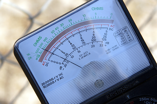
In short, Nichola Tesla theorized that electricity could be conducted through the air and went about creating experiments to prove this. This cache is placed under high tension wires in an effort to help the cache finder recreate a couple of Tesla's experiments. We took a voltmeter and conducted our experiment, getting a slightly higher reading for it after we touched the fence with the volt meter. Using the voltmeter probably wasn't necessary, as all you had to do was touch the fence and you'd get a mild shock from the excess electricity coming from the wires to the chain link fence. As you can see from one picture, the electrical wires hang fairly close to the ground.
 When the gang that accompanied Losel2 on his 4000th came, they came at night, which was probably the better way to go about it. After coming home and logging the cache from our daytime excursion, I looked at some of the pictures in the gallery. Impressive is one of the words I'd use. Fluorescent light bulbs lighting up just by touching the fence are standard pictures there.
 The one thing I've learned about geocaching is to always expect the unexpected. Local cachers know their area best and show off the unique aspects of their area in creative ways. Well thought out caches that take you to interesting areas you probably wouldn't even think twice about on normal days if you didn't understand geocaching help with the enjoyment of this hobby. Had I not been a geocacher, I never would have stopped here. It was a fence next to a dirt road. There's lots of them out here in the desert. But add an electrical field into the picture and you have science in action which makes for a learning experience. Something like that makes my top 5% list every time.
Pictures were taken at or near the following geocache:
Night Caching: The Tesla Experiment - by KG6EAR & co-maintained by WindyMatters!

Monday, August 31, 2009
Montana
After getting to Couer d'Alene, Idaho, we spent most of the day just resting. We'd literally been on the road for nine straight days and caching all of those days. I slept in a little, then spent the better part of the day just watching the water lap up on shore. 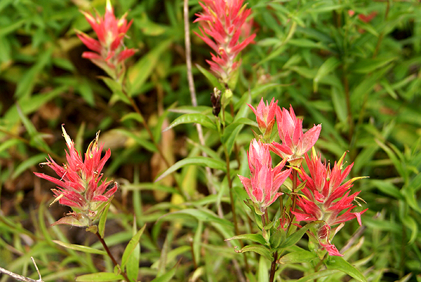
The next day, the Tadpole and I had decided that we wanted to do some caching along Interstate 90. We figured we'd spend most of the day, grabbing caches here and there and would eventually make our way into Montana, which would be our 5th and last state we would cache in on this trip. I had placed three caches inside Montana into the PQ I ran for the trip.
Just inside the border there were dueling rest areas on both side of the interstate, with caches hidden at each one, so those two made obvious choices. Since we were driving east, we had to get off the freeway and make our way to the westbound side, so the first exit into Montana past the rest areas, I noticed another cache, so I put that one in there as well.
The eastbound rest area, our first cache find in Montana ended up being the most enjoyable and also the most difficult find of the three we found in Big Sky Country. The rest area was a bit of a geographical curiosity for these two Southern California boys. 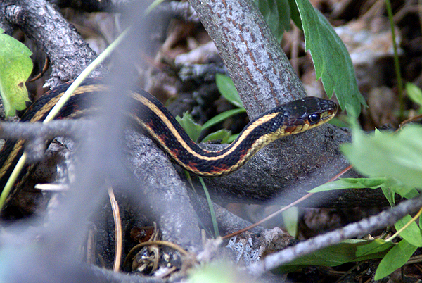
Eventually, we headed over the cache area. The cache was well hidden away from the main rest area along a service road. We didn't have to worry about muggles trying to figure out what we were doing. Behind the rest area we found a stream, with a multitude of plants and trees growing beside it. Wildflowers were blooming everywhere. I noticed Indian Paintbrush, Lupine and some sort of daisy alongside the service road.
We also spotted snakes. At least the Tadpole spotted snakes. I just spotted one garter snake, but it was a nice two footer who seemed to tolerate me getting close enough to get a decent picture of it. 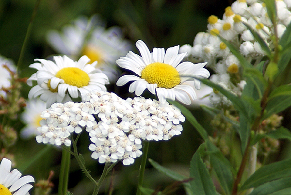
At first, I thought we might strike out on this one, but I've found with perseverance, we are usually successful. The key was taking my camera back to the van. I know I don't tend to search as vigorously when I have my camera strapped around my neck, so the act of putting it back in the car, I believe, liberated me enough that I wasn't as afraid to put my hand into bushes in search of the cache. In this case, it wasn't bushes that I needed to be parting, but rather rocks that needed to be moved. We had the cache in short order after that. Because of the scenic beauty of the area, I put this cache on my top five percent list. It was a worthy addition to the list.
Pictures were taken at or near the following geocache:
Rockhound - by RockhoundMT

Monday, August 3, 2009
Rats
The third day of our camping trip was devoted to breaking camp and moving northward. Our plan was to spend two days in the Point Reyes area, then move north to Redwoods National Park where we'd camp for the rest of the week, so 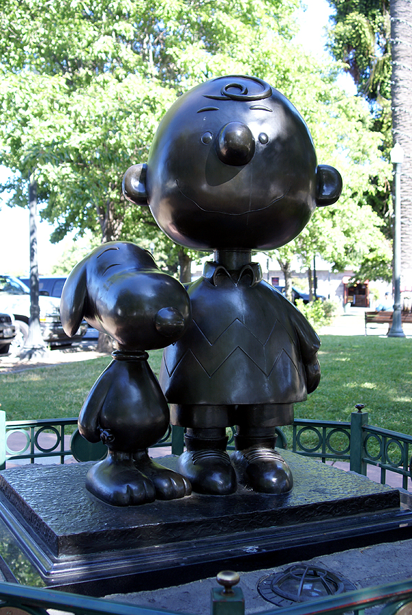
This particular trip really was the first trip where the Tadpole and I had made geocaching the primary focus. In other times, we'd spent time geocaching, but it wasn't primary like it was this trip. That created a little bit of a problem on this particular day. With another goal being to get caches in each county we passed through, we had to find at four or five caches spread out over several hundred miles. We had thoughts of looking for one of the oldest caches hidden in California, but that didn't pan out either due to muggle activity in close proximity to the cache.
We had one side trip to Lake County along Hwy 20, but for the most part, we just headed up Hwy 101. Every time we crossed a county boundary line, we started looking for caches to find. Once we got into Humboldt County, I knew we were good since we were going to end up spending a lot of time in Humboldt and Del Norte Counties over the next couple of days, so those two weren't as critical on this driving day.
I ended up taking pictures at two different caches. One was a tribute virtual cache to Charles Schulz the author of the Peanuts comic strip. As a boy, Peanuts was one of the first strips I'd always look for in the Sunday comics as well as the daily strips. The Tadpole reads the re-runs found in our paper, so he's well versed in the mannerisms of the different characters.
Santa Rosa, California, in Sonoma County is where Schulz made his home. There is a museum celebrating his life and legacy and several monuments including a small sculpture near the city's information center. Unfortunately, there wasn't any free parking in the surrounding area, so we felt rushed as we walked through this small park to the sculpture. The meter was running syndrome 
The other cache that stood out in our minds was the last cache we found in Mendocino County. This particular cache we had decided that we were going to bypass to save some time. We'd already found another cache in Mendocino County, so we didn't need another, but as we came around the bend, I happened to look at the GPSr, saw the name of the cache and made a quick stop. The Tadpole, obviously wanted to know why we were stopping so I told him the name of the cache and he blurted out, "Are you serious?!?" We used teamwork to make the grab on this one, had a good chuckle while we signed the log and then used teamwork again to replace the cache.
It's these kinds of caches that usually strike my fancy and end up on my 5% best cache list. They might not be really great in many ways, but they made me laugh or bring back fond memories. Both of these caches certainly did.
Pictures were taken at or near the following geocaches:
Oh Nuts! - by Bryce and Laura Powers
Pit Stop - by Huntnlady...Adopted by 007BigD

Saturday, April 18, 2009
Someone Else's Backyard
Long time readers know that one of the reasons I enjoy geocaching is it gets me out on trails in my local area. Basically, it gets me to explore my own back yard, 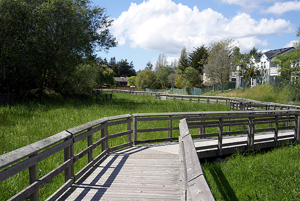
After the tour of campus, I could tell my son was tired. He let me know that he had a headache and so we went back to the motel room where he ended up taking a nap. I looked up geocaching.com on the laptop and discovered a small cache on the boardwalk, plus another couple of caches to the north of the motel, including a virtual. After getting the small cache under the boardwalk, I headed north.
The first cache was a bust. It looked interesting because there was supposed to be a benchmark there as well, but it was in an awkward spot, sort of in the middle of traffic. The cache page had warnings about little children and where they shouldn't be and I was uncomfortable looking for the cache because of the volume of traffic on the two streets that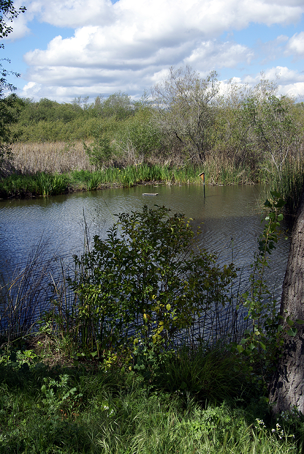
If you've ever been to Santa Cruz, you know it has hills. They're nothing like San Francisco's hills, but I got a good workout nonetheless. The street layout of the city, due to the hills and the curving bay to the south makes it difficult to make a straight line direction to anything, but I eventually found a way over to where I needed to be.
What I found was Neary Lagoon. It's a freshwater wetlands area in the middle of a residential area. At first I thought it might be a salt water lagoon, but that opinion was quickly changed once I started walking on the trail. At the beginning of the loop trail, there were interpretive signs that for some reason I didn't read. Usually, I always read the signs and look at the maps, but I didn't this time. Because of that I was in for the surprise of my life and a nice treat.
I had my choice of left or right on the trail and I chose right, mainly because that's what I ended up seeing first when I approached the entrance to the lagoon area. It was actually a very good choice, because I felt the climax of the trail was at the end of my hike, so it worked its way up to bigger and better things as I walked.
Almost the entire path, at least on the side I started was a wooden boardwalk over grasses and different kinds of flowering plants. There were view points along the trail with interpretive signs, all of which I read. The first part almost felt like I was infringing on some one's backyard because there were townhouses that literally 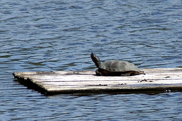
When I came out of the natural tunnel I was on the lagoon. The walk now floated on top of the water and there was a large island. I could see turtles sunning themselves on makeshift landings that had been provided for them. Coots and mallards were swimming in the water and sitting on the shoreline. The walk had become one of those pleasant surprises that geocaching throws at you from time to time. I was experiencing someone else's backyard this time, not my own, and it was grand.
At the far end of the loop was the virtual cache. I needed to get information off of the sign to score the smiley on this one. Originally, there had been a cache at the site, but somehow it disappeared. Perhaps a clumsy geocacher dropped it in the lagoon? 
Eventually, I left the lagoon and got onto a dirt trail that wound around the north end of the lagoon on the shore. There was a water treatment facility just to the north that I suspect is where most of the run off for this lagoon comes, but it didn't detract from the overall atmosphere of the walk.
Nearing the end of my walk, I noticed that I was going to end up crossing over a small "stream" that fed the lagoon. There was an area of water overflow here and much to my surprise, I ended up coming almost face to face with a very large Great Blue Heron. It eyed me for several minutes, giving me enough time to take a couple of pictures, then slowly rose out of the water, flew off and settled somewhere else in the overflow that
This was the third time I've cached in Santa Cruz County. I haven't been disappointed yet with the caches I've found. Perhaps I could say I'm also lucky that I've ended up finding some real gems for caches up there. Who knows? Maybe the hiders in that part of the state just like to hide slightly better caches than in other areas. I did notice there didn't seem to be a high degree of cache density in the area we were staying, so that could be the reason. Whatever the reason, this particular cache ended up on my top 5% list for rather obvious reasons. Next time you're in the Santa Cruz area, you'll probably enjoy the hour of your time to walk around the lagoon.
Pictures were taken at or near the following geocache:
S.C. Birdwalk Cache - by grumpybear and jtkcacher

Tuesday, April 14, 2009
Less than 5%
For those of you who have been following this, you know I have a Top 5% bookmark list of what I consider really good, well done caches. I don't believe the list has ever gotten up to 5 percent. As of this morning, I have 87 caches that 
Today, as I was looking over the list, I noticed two of the caches have been archived. It's been my practice to remove the caches from the list once they've been archived. Since no one can find them, it doesn't make sense to keep them on the list. I've made on exception with that guideline. I keep Who waxed Mr. Ed? on the list because it was a virtual, so there wasn't any cache container to find, and because the ride through the area is still what got the cache on the list in the first place.
The first cache that I removed was called Rock in a Hard Place. There was a certain creepiness factor involved with this one. It was hidden underneath a footbridge in a regional park near me. There were lots of spiders crawling around in the support beams of the bridge. I liked the fact that you could be under there looking for the cache and people could be riding over the bridge and not realize that you were even down there.
The other cache was an urban micro. Almost all urban micros never make my list. This one, however, was very cleverly done, being situated outside a coffee shop. There was a bench nearby, with a statue on the bench. The cache page directs you to sit on the bench and think about it. That particular day I was with a group of cachers and we all ended up sitting on the bench to contemplate where the cache might be. When it was my turn, after sitting with the statue for awhile, it dawned on me that he might be looking at the cache. Sure enough, it was hidden in a support for a parkway tree and the statue was "looking" right at the tree.
It became a simple maneuver of, "hey, why don't you take my picture while I stand over here." Thinking about that cache brings back very fond memories of the day spent caching with 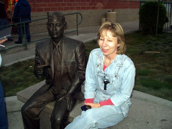
We all know that caches won't necessarily last forever. This game is forever changing and so caches come and go. Still, it's always sad when a good cache disappears for whatever reason. These types of caches, the ones that make you think, are one of the many reasons why I like to geocache. It's like solving a puzzle and some of the puzzles are more complex or more fun to do than others. The really good puzzles get to be on the list.
Pictures were taken at or near the following geocaches:
Who waxed Mr. Ed? - by fooshfoosh and family
Little Tokyo muggle-me-not - by OLdweeb

Monday, March 2, 2009
Smile and the World Smiles with You
In a quick post last Saturday, I wrote about a gigantic smiley in the desert and that we were going to attempt to find all of caches in the series. 
We left our house near 8 o'clock in the morning for the drive up to Victorville in the high desert. We had a couple of side trips to grab a couple of virtual flags that were out there and once we nearly got those taken care of it was time for lunch. After lunch and a couple more caches and one more flag, we decided to head on over and tackle the smiley series.
At first we weren't sure how we were going to progress on this trip. We found a nice dirt road in that went up and over a small hill. At the top of the hill was a nice pullout for cars, so we stopped there. Well, the other reason that we stopped was a cache not 56 feet north of where I'd parked the car. It was the first of the caches in the series.
The caches were all hidden in similar fashion using material that had been found out in the desert, so the hides were fairly easy. We just had to make a decision after the first one and that was how to proceed. Not having four wheel drive made the decision a little easier. We decided to hike the series. It had been advertised at a 1 mile in diameter circle, meaning the circumference of the circle would be 3.14 miles. Well, it wasn't quite like that, because there was another semi-circle making up the smile and also the two eyes.
At the first cache, we also noted that someone else had been out doing the series either at the same time or earlier in the day. We saw Clayton and Karen in every log book, but we never did catch up with them Saturday. After our second find around the outer circle, we cut in to the right eyeball, since we were at the closest point to it. 
I've been able to cache a couple of other series like there, where all the caches had a them to them. One series really sticks out in my mind because every cache container was exactly the same and it was hidden the exact same way. The only difference was a slight deviation in the name. We had to take meticulous notes on that series so we didn't make a mistake later on when logging the caches. This one had similar elements, but there was enough variation, especially the names of the caches, that it didn't become a problem.
The first section of the series was rather uneventful. When we got down to the south east part of the face, we started doing zig zags back and forth between the chin and the smile so we could get as many of the caches in the least amount of distance. At one of these zig zags, I spotted a small burrowing owl flying just over the tops of the mesquite. It landed near a mound that I assume was its burrow, but didn't want any part of us even though we were quite a ways away. As soon as it thought that we were moving closer to it, it took off again.
Midway through the smile, things began to get interesting. We found a cache, and discovered another set of names after Clayton and Karen's, that of Gumby and Pokey. This was a little perplexing since we hadn't seen their names in previous logbooks, yet here they were now showing up about halfway through the series. As we continued the hike, we realized they must have started the opposite way and traversed the smile in a counter clockwise direction while we were doing the same thing in a clockwise direction. We had to have missed each other while we were zigging and zagging between the smile and the chin.
Interestingly, Gumby and Pokey are old time cachers like me. They joined Geocaching in February 2001 about a month before I found out about it. I've found several of their caches in my neck of the woods and they've 
There was also a mystery/puzzle cache attached to this series of caches. Clues to the whereabouts of this cache were to be found in the other caches around the smiley. Halfway through and we'd pretty much figured out where the mystery, or final as we came to call it, was going to be. We still needed some more information and we eventually found it in the other caches.
Looking at the maps, this must have taken some time to put together. It's not a wonder that it was a team of cachers, Dog Will Hunt, bigdaddygrc, Mr. G., and Rhino Assault Team that put it together. It's pretty simple math to decide where to place all of them (each cache was 22½ degrees around the circle), but finding the right spot and doing all the logistics would have taken a long time for just one cacher. Three cachers probably spread out the work load.
The sun was setting and we were nearing the end of the journey. We'd found the last piece to the final cache, so we decided to to get that before getting the last of the outer rim. This saved us about a quarter mile in walking, not much when you really think about it, but we were tired and that last mile just seems to take a toll on you. The final was an ammo can with lots of goodies in it. I decided to take a diabetes travel bug. Chaosmanor placed a couple of travel bugs and a geocoin to cover what I'd taken. Now it was off to the last cache on the outer rim and then a short 2 tenths of a mile hike back to the car and home. The final can be seen on the last map as the smile next to the Interstate 15 freeway. It's obviously not there and you can probably figure out where it really is hidden.
We had to hike up over a small rise to get to the last cache and from up there we could see out car in the dwindling daylight. I could see two people near the cache just next to the car and I put two and two together and figured that it had to be Gumby and Pokey. No one in our party can whistle loudly, so I shouted, but the desert air apparently stifled my cry. However, I could see that as we were approaching the final cache, they too were heading in the same direction.
We got over to that cache and waited for them. As they approached, I heard Pokey shout out, "Webfoot?" So immediately, I shouted out, "Gumby and Pokey!!" I've always found meetings between geocachers on the trail to be enjoyable and this one was no exception to that. It was fun to put faces to names that I'd seen ever since I started caching. Eight 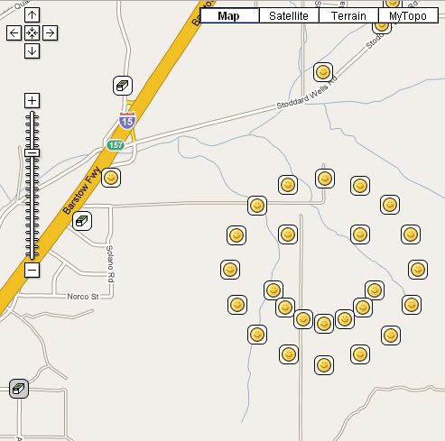
After signing the log for that last cache, we said out goodbyes. They still had to find the final and it was getting dark and we needed to be on our way as well. I put the final on my 5% list mainly because it represents the entire series of caches and was the best of the bunch. My one regret was not taking my camera. I'd opted to go light on this trip mainly because I knew it was going to be a long hike and it would have been tiring to carry it around all afternoon. Still, a picture of Gumby and Pokey would have been nice. I'm still trying to figure out why that blue bra was wrapped around a Joshua Tree out there near one of the caches. Bet that made you smile.

Saturday, February 14, 2009
Wow Factor
Over a year ago, I wrote about virtuals and why I thought they had been discontinued by Geocaching.com. The powers that be at Geocaching tried to 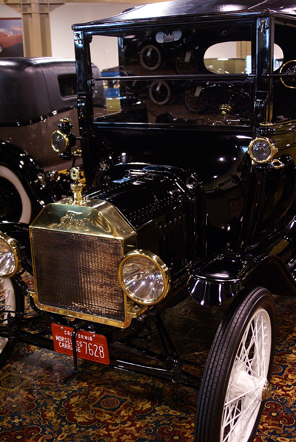
Virtuals are caches that aren't really there, if that makes sense. You go to a specific spot, take a picture and/or gather some information for the "hider" and you get credit for a cache find. I like virtuals because they allow me to find "caches" in spots where I can't find a physical cache, like in a national park, such as Joshua Tree or Grand Canyon. My son and I have found virtuals in both of these parks and in other parks as well. The virtuals in Joshua Tree got us to a trail and spot that we normally wouldn't have gone on if they hadn't been there. We learned some interesting stuff while at these virtuals, including some local history.
The problem with some virtuals is they were missing the "WOW" factor. With a virtual at a national park, the obvious WOW factor is pretty much built in. Once you get to a spot, you usually say "WOW!" and you know it's all good. 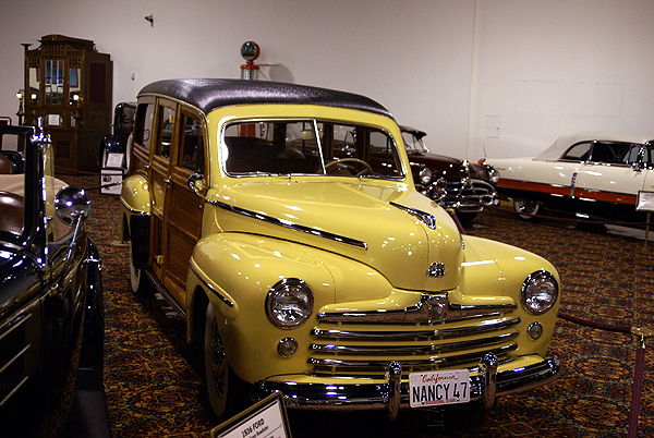
Thursday, I posted about a Vexilla run that I was planning for the next day. It was a successful run, netting me all four of the virtual flags that I'd intended on finding, plus seven caches and one benchmark. All in all, it was a very good day. I also discovered a virtual cache that definitely has the WOW factor.
We'd planned on getting the virtual cache, Putt-Putt, Beep-Beep that morning. I wasn't sure what to expect at this cache outside that it was a museum showcasing classic cars. I tend to not read cache pages in depth very often and I 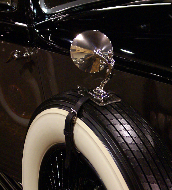
As you can see by the pictures this place was huge and had some magnificent cars in it. There was one entire row of classic Rolls Royce's. Every car, with the exception of one had been restored to pristine condition. The attention to detail was phenomenal. There was evidence that polishing and cleaning is a never ending job in this place. Once we'd found the answers to the questions on the cache page, we could have gone on our merry way. I think we left at least an hour after we'd found the answers, the place was that fun.
One of my favorite cars in the collection was the 47 Woody with real wood paneling and a beautiful yellow paint job. The only thing missing was a surfboard. Then we entered a side room and saw the pièce de résistance. In the side room was the original 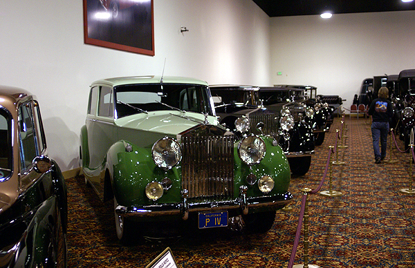
Eventually, we had explored every nook and cranny of the place and it was time to take our leave and continue our cache run. I'm sure that some auto fanatics could spend an entire day in there. I probably could if I knew that I didn't have any kind of agenda for that particular day. Not only that, the price is right, since it's a free admission.
It's fortunate that this particular virtual was created before the moratorium happened. Hiding a small micro in the bushes outside of the museum wouldn't necessarily get people to come inside the museum. I could see many people just stopping by, logging their find and moving on. They would lose because although the cache was a
The pictures on this page are just some of about a dozen or so that I posted in my log for the cache. Feel free to click on that link and see the rest of the pictures there. Oh, by the way, did I mention there's a train out in back?
Pictures were taken at or near the following geocache:
Putt-Putt, Beep-Beep - by HenryKnowsBest

