Once you have your data in a text file, either by using my method, or by using reader Benh57's method, you'll need to upload it to a server. Most ISPs allow individual webspace and there's plenty of free spots out in the world wide web for you to do this. Once that is done, you just need to set your parameters for the kind of map you want.
I don't have know all of the parameters that can be used, so I'll interpret what's listed above for what I have on my particular map. All of the other parameters can be found here.
One of the things that I wanted to do was have a map that concentrated on the areas where most of my caching would take place, so I wanted to have the map centered in such a way that Southern California 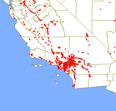
The next two numbers specify in decimal degrees, how tall and how wide the map will be. In this case, the map will be 14 degrees by 11 degrees. By changing this you can cover larger or smaller areas of the globe. By making the numbers smaller, you'll obviously zoom in on a given area, which is what I did to show you the smiley out in the Mojave desert that we created when we found the Smiley series of caches.
The last two numbers creates the size of the map that will show on your screen. The default is 256 by 512 pixels which was a little too small for my tastes, so I upped it to 600 by 800. Once I get a bigger monitor or a new computer, I may up those so the map will fit on my screen again. The last thing I wanted for my map was to have the county boundaries show up, so I added the "on=counties" parameter. You can add railroads, streams and major highways to your map, depending upon what you want to display on your map. The choices are totally yours.
The last piece to the map is to add the url of your text file wherever it is stored. My caching map can be viewed here. The Tadpole's map showing his cache finds can be viewed here. The one thing to remember is the entire URL for the map, including all of the parameters is limited to 256 characters. Play around with it a little bit and you'll soon have a map to your liking.
Friday, May 1, 2009
Cache maps Part II


Wednesday, April 29, 2009
Creating a caching map
Every time I go caching, I log the caches on-line. Then I update my spreadsheet and then the mapping file so I can update the map that I keep on my profile. This past weekend, I suggested to the Tadpole that I could create a map for him. He was enthusiastic 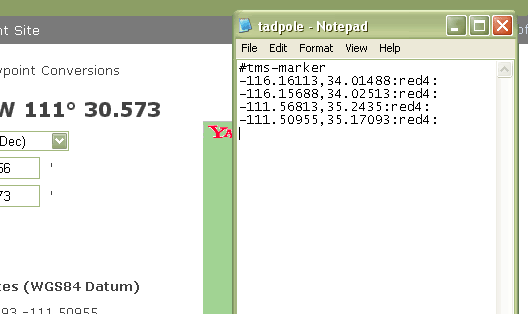
I also wanted to see how many counties he actually had on his "official" finds list. He's recently become interested in finding the 58 county challenge cache. His "official" county count is small, only nine counties because he refuses to count any cache that he found with me before he started his own geocaching account. That's fine, except that we have some work to do for him to catch up to my county find total so we can get this cache together.
While I was making his map, I thought it might be a good idea to share the know how so that others, if they wish, could create a map of their finds. I've started to write something like this several times in the past, only to be stymied by the technical aspects of this, so I'm probably going to break this up into separate parts.
The first part of making a Tiger map is to create a text file of all the data points you want to include on the map. In this case, I had slightly over 300 data points from all of the Tadpole's cache finds. I've found that Notepad seems to work best when creating a .txt file, so I just opened up a new one of those and began inputting the data. In this case, the map file needs to start out with the header, #tms-marker as shown above in the picture. Then it's just a simple task of adding all the data points.
All the geographical data points have to be in decimal format. Since the cache pages all list the coordinates of the cache in degrees and minutes format, you'll need to find the decimal equivalent. So where do you get the decimal translation from a geocache page? 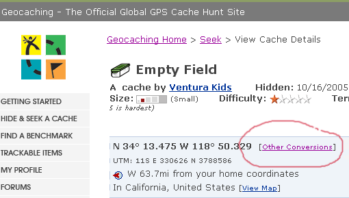
Expect to spend some time entering all the coordinates into the text file. I took a couple of hours to input all of the Tadpole's cache coordinates into his text file, but that time is a one time deal. If you keep up to date after the initial inputting, it doesn't take much time at all to maintain the file. I'll explain how to create the parameters for the map in my next post.

Sunday, April 12, 2009
Alameda
On Saturday, my son and I drove from Santa Cruz up to Stockton to visit my daughter. We'd been touring UC Santa Cruz because it's where he has decided to attend college beginning in the fall of this year. The rest of that story will be 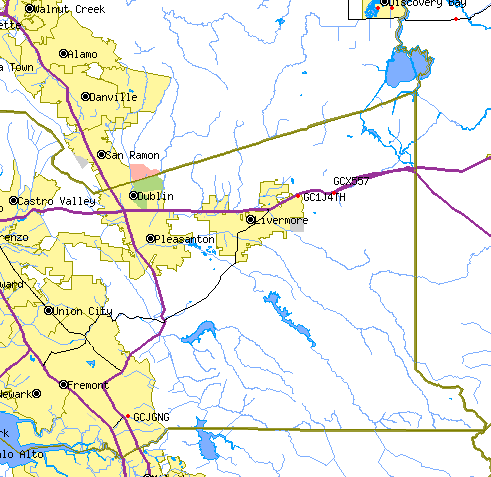
The first cache we found in Alameda County was Curtner Coppice. It's (GCJGNG), which is located to the southeast of Fremont. For me at least, it was a little tricky, only because I wasn't able to see the hiding place right away and I was taking the clue for the cache a little bit too literally. Eventually, I was able to find it, obviously and add Alameda County to my list of counties in which I've found caches. I found two other caches in the county (just east of Livermore) just to be on the safe side. With the first cache, we'd just passed the county line marker sign and I wasn't sure how the county line ran, so I wanted to make sure by finding a couple of other caches later on. You can see by the map, that I was well within the county line for credit.
That brings me to 32 counties. I have but 26 more to go. As noted previously, it probably won't happen this year, but could happen in the fall of 2010. I'll need two trips north, one on the west side of the state and then a second trip on the east side of the state to get all of the counties in the northern part of the state.

Saturday, March 28, 2009
Adding more dots
I've always been interested in maps from a very early age. I can remember being asked by my 5th grade teacher to place all the states on a map of the 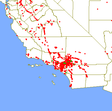
I'm not using my degree specifically, but I do use the information I learned as part of my daily curriculum that I pass on to my students in their history classes I teach. So in a way, I'm using my degree as part of my career. I'd say I probably use my degree, or interest in geography in my hobbies more so than in my career. I discovered Where's George?, the money tracking website back in its early stages in January 2000. The concept that you could track your money after you spent it and see where it went was intriguing. I've seen the money I've spent travel to every state in the United States and several foreign countries.
I can't imagine people not being interested in geography if they're at all attracted to geocaching. The entire purpose of the game is to work with
The geographic map I have in my head of certain area every now and then needs to get tweaked a little bit. I would be willing to bet that most people, if they think at all of regions of California, probably break the state up into two main regions, north and south. Earlier this week, I was caching in eastern California. Sometimes, I find it difficult to wrap my mind around that one. The state if long and lean, so I don't really think about it as being east and west, yet there I was, in what can really only be considered eastern California.
Inyo County is located on the eastern edge of the state, bordering Nevada. I knew I was east, yet when I added my cache finds to my caching map, I was surprised to see where the dots ended up on the map. I shouldn't have been, since I knew I was only 27 road miles from 
I'll continue to add more dots to this map as I continue to geocache. Expect to see more dots show up on the western side of the state. My older son has been accepted at University of Santa Cruz. Besides the regular trips I take to visit my daughter in Stockton, I'll now be adding trips to Santa Cruz as well. Santa Cruz is located near the ocean, south of San Francisco along the northern edge of Monterey Bay. You can see two cache finds on the map, one of which was a webcam cache that we found in the city limits of Santa Cruz. Our first scheduled trip up there will be next month during his spring break.
I've enjoyed the past two years watching my daughter spread her wings in college and the next few years I hope will be just as enjoyable as my son does the same. I will miss him much like I miss my daughter, but at the same time I understand that he needs to be out on his own now. He has changed so much since his geocaching days. His time with us full time is growing short. I guess I'll just have to travel more often and visit him where ever he is.
Picture was taken at THE LOST AMADEUS - by LIZARD

Monday, March 23, 2009
Another challenge?
I was looking at my DeLorme atlas yesterday. It is normally perched beside my computer. I actually have four atlases there, two AAA atlases and two DeLorme atlases. The two DeLormes cover all of California. I purchased them several years ago, quite possibly before I started geocaching. I use one of the AAA atlases for when I'm traveling and the other I use to scribble all over. Most of the scribbling is highlighting the roads that I've traveled on in my lifetime. It's an approximation, because 
I've been having some Internet problems and I finally got fed up with them on Saturday and pretty much solved the problem by upgrading my modem for my DSL line. Installing this, I had to pull out parts of the computer desk and one of the things that had to be moved were the atlases. When I put them back, I looked at them, mainly because my daughter had used them two weeks ago when she was here with a couple of her friends. They'd used them as their primary map for Southern California when they went to visit Hollywood. I decided to look at it to see whether it would have been helpful to them or not. On that verdict, I'm not sure what the outcome would be, but they didn't get lost, so I guess it was useful.
As I looked over the Southern and Central section atlas, my mind started to wander to this particular geocaching challenge that I'd heard of, but hadn't really given much thought of attempting. I kept thinking to myself, that I really didn't need another challenge, but then I also kept thinking as I perused the pages, things like, "I've found one on that page, oh and also on that page!" So I started counting them up and came up with 57 pages where I've already found caches. According to the cache page, there's 110 pages where I'd have to find a cache, so I'm already half way there without even trying.
Of course, the pages where I don't have cache finds are the ones that are the most remote. Many are out in the desert to the east of me, or in the Sierra Nevada, or in the middle of farm country in the central valley of California. There are several pages that will require some extensive planning in order to find a cache. This challenge is definitely more of a challenge than the 58 county challenge is. With the county challenge, driving the roads through the counties will work, because there's always caches hidden alongside highways and byways. With the DeLorme challenge, there's not necessarily a road within the map boundary, which means hiking.
As I looked over the atlas, I realized this could be too much on my plate at one time. My original goal was to finish the California County Challenge. I don't want to give that up just to switch to a new challenge. What I think I'm going to do is to continue the county challenge, but keep the DeLorme challenge in the back of my mind. Other map pages will be found as I work my way around the state. I think it also gives me new incentives to explore other areas of the state that I haven't done before. Of course, as I begin working on the counties in Northern California, then the Northern California DeLorme challenge comes into play as well. Together, these three challenges together will create a nice diversion for me and keep me busy caching for many more years. I can deal with that.

Wednesday, March 4, 2009
One last smile
I created this map using the Tiger Mapping Services offered by the United States Census Bureau. It's a free service that allows 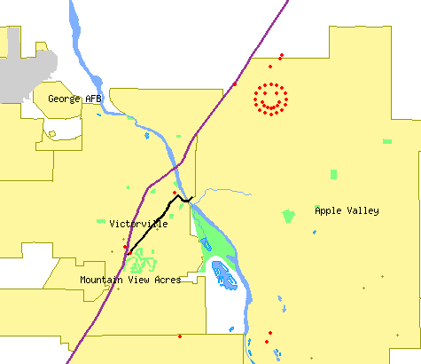
There are all sorts of parameters that you can set with these maps. I like to see the county lines on the maps since I'm interested in finding a cache in every county of California and that allows me to see at a glance what counties I still need. I like the map because I can actually pick out various caching runs I've gone on with friends. The scale doesn't show the smiley cache run as more than a blob, so I zoomed in on it for this particular map.
If you look closely, you can see other red dots on the map. The two red dots in between Mountain View Acres and Victorville are two caches with ties to Route 66. The northern dot was found by the three of us last Saturday as we made our way over to the smiley caches. The southern dot is a virtual located at a very cool Route 66 museum that I wrote about previously.
As I'm writing this, I think perhaps I need to write a tutorial on how to make these maps. If you don't have too many cache finds, it's a relatively easy proposition to make one for yourself. I have the cache hides and finds map linked on my geocaching profile.
Tuesday, February 26, 2008
Using GSAK Polygon Filters
Finally, the last episode in the adventures of GSAK line, arc, and polygon filters! Since we've already covered lines and arcs, that would leave . . . . POLYGONS! If you were paying attention during Geometry class, you know that a polygon is is a plane figure that is bounded by a closed path or circuit, composed of a finite sequence of straight line segments (i.e., by a closed polygonal chain). These segments are called its edges or sides, and the points where two edges meet are the polygon's vertices or corners. The interior of the polygon is called its body. Also, in a simple polygon, the boundary of the polygon does not cross itself.
You did remember that, right? Right?? Oh, well, even if you didn't, I'm sure you have the idea. A triangle is a simple polygon. So is a square. So is that hexagonal stop sign at the street corner. Unlike those examples, which are all convex and often equilateral, a GSAK polygon can be any shape as long as it is simple (no crossing edges), and each of its sides can be any length.
This filter will select all of the waypoints that are contained INSIDE a closed polygon. You can have as many sides to the polygon as you wish. To keep the example simple, I will just take the route I used in the previous example, and turn it into a closed polygon by connecting my last  Second, the LAST lat/long in your polygon definition has to be the same as your FIRST – that is, you have to CLOSE the polygon. Notice in the following filter that the first and last lat/long pairs are the same, and also that the box for specifying distance is no longer available.

Here’s the map, showing the closed polygon, and all the caches contained inside that area.
 Finally, one other option that wasn’t discussed earlier is the “Exclude” option on the Arc/Poly tab. If you check this box, it basically reverses the filter – select all waypoints that are NOT within “x” miles of these points, select all waypoints that are NOT within “x” miles of this line/arc, select all waypoints that are NOT contained inside this polygon. Go back and take a look at the original map showing ALL of the northern
The "Exclude" option works just as well with points, lines, and arcs -- that is, you can find everything that is NOT within 5 miles of a point (for example), or NOT within 2.5 miles of a route. You're limited only by your imagination!

Tuesday, February 12, 2008
Using GSAK Arc Filters - Part II
Ready for a more complicated route? I’m going to travel from

And here’s what the GSAK filter looks like:

Notice that you have to list the coordinates in the filter in the order they will occur on the route! When I apply that filter, I get 197 waypoints, which are plotted on the next map.

Saturday, February 9, 2008
Using GSAK Arc Filters - Part I
Enough of Webby's warm and fuzzy stories! Let's get geeky again!
Just a short time ago, I explained the basics of using a GSAK point filter and then extended that to including multiple points in a filter. With a few clicks of the mouse, it's easy to move on to an arc filter -- similar to gc.com's "caches along a route", but working from your offline GSAK database. (In fact, before gc.com introduce the oft-requested "caches along a route", this was pretty much the only way you could do it.)
We’ll start with a real simple one. You notice that the two points I used before in Schaumburg and Lombard have a north-south road that nearly connects them. For the sake of this example, let’s assume that I plan to travel on that road, and as I travel from Schaumburg to Lombard, I’m willing to go about 1-1/2 mile off my route to find a cache. So this example is very simple. In the filter, I will select “Arc/Line” instead of “Points”, and will limit my distance to 1-1/2 miles.This gives me 44 waypoints, all within 1-1/2 miles of the black line on the map which connects the two points of the arc. In this simple example, since I only have two points, it doesn't matter in what order I list them in the filter.


Wednesday, January 30, 2008
Road Trip
I graduated from college with a degree in geography, so I love maps. I’ve always loved getting out the atlas and pour over the individual state maps and see where I might want to go next on a vacation. Where was our next road trip going to take us? Should we take this road, or that one? I wonder what this town is like? Next month, I’m planning a road trip to
There is a mystery cache in  of the summer. Anyway, this series of articles is just designed the document the road trip.
This particular road trip took some advanced planning. I decided that this one was going to take the scenic route, so I’m going to be traveling on a lot of back roads this time, which is fine with me, but making the route queries for this one took a little bit longer. After searching the geocaching data base, I was only able to find this one route that fit my needs for any part of the trip. All the other routes, I had to create. In the end, I have 8 different route queries that I’m going to have to run right before I take off on my road trip. That also is going to take some planning since I can only run five per day. I need to remember to run at least three of them two days before I leave, otherwise I’m screwed.
My next step has been to go through each route and check out the mystery/puzzle caches to see if I can solve some of the puzzles and get those. Interestingly, there don’t seem to be a whole lot of puzzle caches, but I have gone through and solved 12 puzzles for the upcoming road trip. Several of them are right along county lines and involved looking up local history for each county. Right now, I’m a little bit more knowledgeable about Calaveras, Amador,
There was a puzzle cache that used Pig Latin, one that used the symbols from a computer keyboard, one that had me investigating a certain government agency within Kern County and two cipher puzzles. All of these puzzles have been solved, now my next step is probably going to be to whittle down the list. I have over 500 caches right now, and since my GPSr doesn’t have a memory card slot, I need to get that down to under 500 waypoints for them to all fit in the unit. Once I load all the queries into GSAK I’ll start by eliminating the puzzles that I haven’t solved. That will probably do the trick, but if it doesn’t I’ll then probably drop the multi-caches. I like multi-caches, but they tend to take a little bit longer to find than regular caches and I do have some time constraints so it makes sense to drop them next.
Tick, tick, tick, tick, tick, tick, tick, tick, tick, tick, tick, tick, tick, tick, tick.

Friday, January 25, 2008
Using GSAK Point Filters - Part II
In my previous post, I showed how to use a simple GSAK point filter. As you saw, it did pretty much the same thing as filtering based on distance from your centre point, but you're not restricted to using your centre point or, for that matter, any cache in your database. The point filter can be based on any arbitrary lat/long you wish (although it's obviously useless to pick a lat/long outside of the area covered by your database).
 Now, let’s do the same thing with multiple points. Let’s say I’m going to be at the Marriott in
You can see that the list of points now includes TWO lat/long combinations. When I apply this filter, I now get 79 waypoints – 17 more than I did for just the

When I plot those on a map, I now have two clusters of waypoints – one set within 3 miles of the green flag in
Coming up next: Arc filters
Thursday, January 24, 2008
Using GSAK Point Filters - Part I
A lot of geocachers use GSAK (Geocaching Swiss Army Knife) for managing an offline database of geocaching waypoints, and most have used simple filters for focusing in on a subset of caches they're interested in. Many I've spoken to, however, have never explored the power of "point", "arc", and "polygon" filters. At first glance, they can seem intimidating -- but they're quite powerful and useful, and once you've tried them you'll find they're not that hard to use. I wrote up some documentation on this subject a while back to share with some other members of GONIL (Geocachers of Northeastern ILlinois), which I'll share with you here. Due to its length, I'll address each type of filter in a separate post. My default GSAK database contains over 4000 waypoints in northern
Let’s look at point filters first. You’ve probably used filters before where you specify an existing waypoint (or a defined GSAK “location”) as your center point and then specify a given distance from that waypoint. That filter would look something like this. A point filter is similar, in that it selects waypoints within a circular boundary, but there are two key differences – you can specify any  arbitrary lat/long coordinates as your center points (not just an existing waypoint or location), and you can have multiple center points.
We’ll start with a simple example of a single point for a point filter. Let’s say I’m going to be at a meeting at the Marriott Hotel in
One way I could do this is to find an existing cache near the Marriott and specify that as my center point in GSAK. But another way is to simply find out the lat/long of the Marriott. There are many ways to do this, but one easy way I do this is to use the website www.maporama.com, because once I find the location I want, it displays the lat/long right there on the map page. So I’ve found the Marriott at  and to the left of the map, I see that the lat/long at that location is 42.05, -88.038 (I’ve highlighted it in blue). (Important note: Maporama displays the lat/long of the CENTER of the current map – NOT the circular target you see on the map. The target may be in a different location because of how you searched. Don’t worry about whether you SEE the target or not – as long as the location you want is in the center of the map, the lat/long displayed is what you want.) Google Earth is another good option for locating the lat/long of a location for you.

So now I go to GSAK and set a filter. Click on the “Arc/Poly” tab. Enter the lat/long of the Marriott into the box on the left, select “Points” as the filter type, and specify a distance. Click “Go”.

When I apply this filter, I get 62 waypoints returned, and they look like this on the map (I put a green flag on the map to display where the Marriott is). As you can see, I could have picked that cache just SW of the Marriott and used it as my center point for a simple filter, but by specifying the lat/long of the Marriott itself, it doesn’t matter whether there’s a cache nearby.
That was pretty painless, wasn't it? In my next post, I'll show how to use multiple points in the same filter.


