This past week, I went on a short road trip to Northern California. I know short is a relative term, but it was short for me in time, as opposed to distance since I put slightly over 1000 miles on the van, plus added two new front tires during the trip.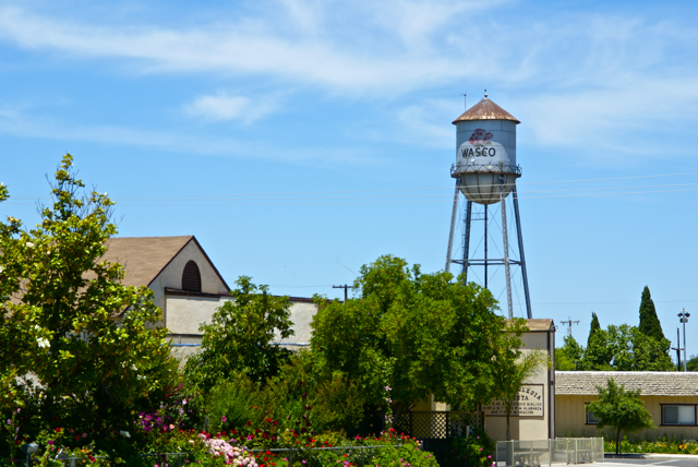
I drove up to Stockton, mainly to deliver extra "stuff" to my daughter, including a couch that she'd gotten from her grandmother, but couldn't fit in her car. There would be a side trip to Santa Cruz to pick up my son as well. Since he wanted to visit with his sister for a little bit, I picked him up, then drove back over to Stockton. This should have been a 4 hour round trip, but it ended up being over 8 hours because a problem developed on one of the front tires and I had to get that fixed before we could head back. Things happen and there's not much I could do about that.
Each time I drive up there, I try to take different routes. I look at the different virtual flags that can be captured, as well as any possible dashpoints, plus geocaches and then I plan my route accordingly. Waymarks and benchmarks are side possibilities, but for those, I just let them happen as opposed to me actively search for them.
If you've followed this blog for any length of time, you know that my most active waymark category is water towers. I love driving into small towns and seeing their town advertised for miles by the large water tower in the center of town. We have few water towers in Southern California, as most municipalities build large storage tanks in the hills above town which provides the same purpose of creating water pressure for the town's water supply.
Towns in the Central Valley of California and elsewhere where no hills are present create their town's water pressure by building water towers. Usually, these water towers promote the city, but some support advertisements for local businesses. The main water tower in Merced, California promotes the newest university in the UC system, UC Merced.
As I drove through the Central Valley this week, I happened to drive through the town of Wasco, CA. I've seen signs pointing to Wasco while driving both Hwy 99 and I-5, but have never gotten off, mainly because the town is out of the way. 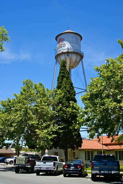
Had I known a little bit about the town, I might have been tempted to stop there sooner. Wasco bills itself as the Rose Capital of the World. Every year it has a rose festival the weekend after Labor Day weekend and the water tower in the middle of town is plastered with a large red rose. After getting home, I discovered that 55% of all roses grown in the United States are grown in and around Wasco by nine major rose companies. It was a pleasant experience to drive through the fields around town and see rows and rows of red roses, then rows of yellow roses. I know I've never seen so many roses in one place before.
If not for the GPS games that I play, I probably would have never passed through this quaint little town. I feel, I'm richer in spirit because of this hobby. If you happen to be in the area on the weekend after Labor Day some year, I think you could do worse than to make a stop in Wasco and take in their Rose Festival.
Pictures taken at the Wasco Water Tower:
Saturday, June 12, 2010
A rose by any other name...

Thursday, February 18, 2010
Brotherly Love
Every now and then, my older son surprises me. This past weekend, I took the Tadpole north to visit his sister in Stockton and his brother in Santa Cruz. I had a four day weekend, so it was easy to pull him out of school for a day so we could do this in a leisurely sort of way. 
When we first got there, he offered to give us a tour of the campus, primarily for his brother's benefit, since I've been to the campus several times. Santa Cruz's campus is located on the side of a hill, so there's several bridges that cross ravines and in general, it's a pretty hilly campus, but a very beautiful one. We saw 18 deer on campus that day, way more than my son said was usual. Apparently, the deer were enjoying the good weather just like we were.
About half way through our walk, my son turned to me and asked me whether we wanted to find any geocaches. Uh, sure son, but you're the one who calls geocaching, that "dorky thing Dad does" with my younger brother. But this time he was honestly sincere that we have a good time and he knew we liked to geocache. I hadn't brought the GPSr with me because I hadn't expected to geocache much that day, but I had brought along the iTouch which has all of my geocaching notes. Because of the WiFi on campus, I was able to pull up the Geocaching site and I noticed a cache called Thimann Tribulation.
My son then pointed and said that the building we were standing next to was Thimann Hall. So we looked up the description and the hint and figured out where the cache was hidden, finding it in what I call "Commando Style," that is, without the use of the GPS. 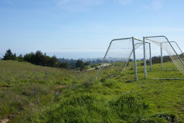
My son even consented to several pictures. It's very hard to get a good picture of him since he doesn't seem to like his picture being taken, but this day was also an exception, as I got several good ones of him around campus. The Tadpole commented after we left for the day that he had really enjoyed himself and really enjoyed spending time with his brother. That's a good thing, in my opinion. For those of you who don't have teenagers yet, this is what is in store for you. The Tadpole was shorter than his brother when his brother left for school last September. The kid is a bottomless pit right now.
Pictures were taken at or near the following geocache:
WUPH4_Best Soccer view in the world - by Mayela Mingi

Wednesday, September 2, 2009
Wallace, Idaho
As noted in the previous log, we did some geocaching in Montana, then headed back to Couer d'Alene. Interstate 90 has some very scenic locations along it in the panhandle of Idaho, so we had ample opportunity to enjoy the outdoors as we looked for caches. One of our stops along the way, was in Wallace, ID, a small town, that obviously has become a tourist stop for vacationers to visit as they travel on the interstate.
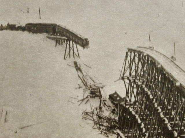
The cache we found in Wallace was near the old train depot. Most of the tracks are now gone from this section of town. Looking at old photographs in the nearby museum, this particular train depot was a bustling building, serving both freight and passenger trains. Those days are now long gone as evidenced by the lack of track around the train depot.
The cache was an easy find with the name of the cache pretty much giving away its location, but it was still fun to find. After finding it, we noticed the depot was now a train museum, so we decided to pay the entrance fee and tour the facility. We also noticed a beautiful benchmark on the side of the building. Before touring the museum, I had to go back to the van and get the camera so I could document our visit to the benchmark. I took a couple of pictures and then we went inside to tour the museum.
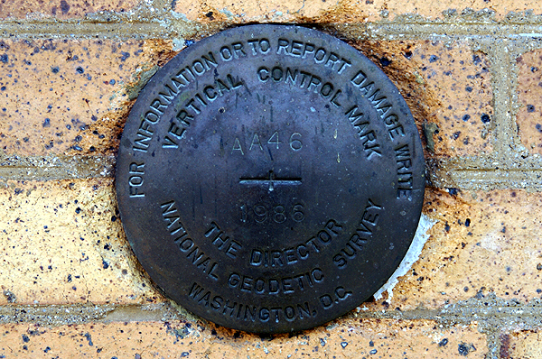
Upon arrival home, the fun began. Well, I'm not sure it's fun, but it was interesting. When I looked up closest benchmarks to the cache we'd found, I found two that by all indications were supposed to be right on top of the cache. That probably meant that there was a good chance that at least one of them was the correct benchmark for the one we'd found. That, was not to be the case however.
Of the two benchmarks listed, this one appeared to be the most promising based upon the description on the benchmark page. The description of the benchmark on the page states that this benchmark is set vertically in the south face of a brick building (the train depot) 4.5 feet higher than the sidewalk. The benchmark was monumented in 1935. That's where the confusion steps in, because the benchmark in the side of the depot is dated 1986.

There is also some geographic confusion. Since both benchmarks are fairly close, there really isn't a way to designate how many feet they are apart from each other if they are less than a tenth of a mile away. That means the database can say there's a benchmark right here, but it could be up to 528 feet away. This means that cachers should be extra careful when logging benchmarks, otherwise they're posting bogus logs for benchmarks they're not really finding. The benchmark information FAQ page indicates that one should try to take pictures of the benchmark, both a close up and one that places the benchmark in its surroundings.
For this reason, I don't log benchmarks that I find unless I've taken a picture of them at the time. I've been on caching outings where we've stumbled across benchmarks, documented them and when we got home, found there were two and three others in the same area. I know for sure that we probably walked right over one of them. But, we didn't take a picture, nor even see it, so I won't log it. And to be honest, I'm not sure why the logging of this particular benchmark, clearly the wrong one bugs me, but it does. I guess I need to get this out of my system since it's just a game and everybody plays the game a little differently.
Pictures were taken at or near the following geocache:
The Cow Catcher - by thehobbler

Monday, August 31, 2009
Montana
After getting to Couer d'Alene, Idaho, we spent most of the day just resting. We'd literally been on the road for nine straight days and caching all of those days. I slept in a little, then spent the better part of the day just watching the water lap up on shore. 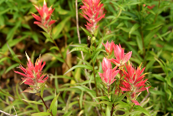
The next day, the Tadpole and I had decided that we wanted to do some caching along Interstate 90. We figured we'd spend most of the day, grabbing caches here and there and would eventually make our way into Montana, which would be our 5th and last state we would cache in on this trip. I had placed three caches inside Montana into the PQ I ran for the trip.
Just inside the border there were dueling rest areas on both side of the interstate, with caches hidden at each one, so those two made obvious choices. Since we were driving east, we had to get off the freeway and make our way to the westbound side, so the first exit into Montana past the rest areas, I noticed another cache, so I put that one in there as well.
The eastbound rest area, our first cache find in Montana ended up being the most enjoyable and also the most difficult find of the three we found in Big Sky Country. The rest area was a bit of a geographical curiosity for these two Southern California boys. 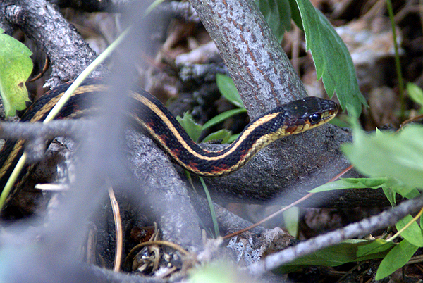
Eventually, we headed over the cache area. The cache was well hidden away from the main rest area along a service road. We didn't have to worry about muggles trying to figure out what we were doing. Behind the rest area we found a stream, with a multitude of plants and trees growing beside it. Wildflowers were blooming everywhere. I noticed Indian Paintbrush, Lupine and some sort of daisy alongside the service road.
We also spotted snakes. At least the Tadpole spotted snakes. I just spotted one garter snake, but it was a nice two footer who seemed to tolerate me getting close enough to get a decent picture of it. 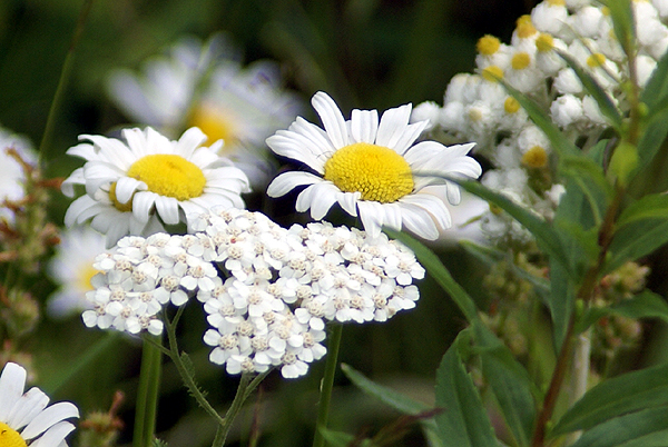
At first, I thought we might strike out on this one, but I've found with perseverance, we are usually successful. The key was taking my camera back to the van. I know I don't tend to search as vigorously when I have my camera strapped around my neck, so the act of putting it back in the car, I believe, liberated me enough that I wasn't as afraid to put my hand into bushes in search of the cache. In this case, it wasn't bushes that I needed to be parting, but rather rocks that needed to be moved. We had the cache in short order after that. Because of the scenic beauty of the area, I put this cache on my top five percent list. It was a worthy addition to the list.
Pictures were taken at or near the following geocache:
Rockhound - by RockhoundMT

Tuesday, August 18, 2009
Underground wonders
While camping in Redwoods National Park, we made a day trip into Oregon to tour Oregon Caves National Monument. 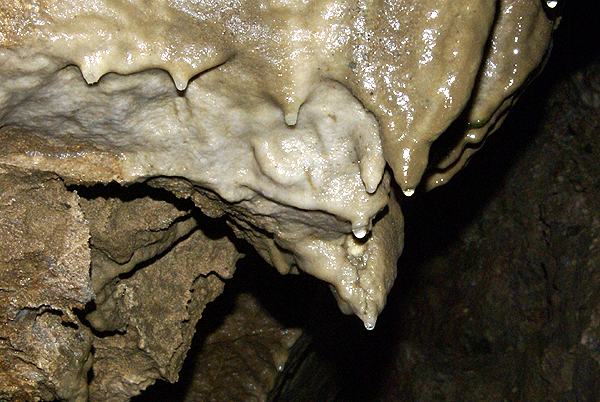
We were fortunate to get as our tour guide one of the park rangers whose specialty is geology, so we got a very informative tour. We got to experience a cave blackout, which is pretty standard on most cave tours, but it's always kind of creepy to experience that total darkness, where no light penetrates. I can't imagine getting lost in something like that, yet it seems that most of the early discoverers of caves seemed to have done just that: went in with minimal light, then had to grope their way out. I guess they all make good stories to tell on the tour.
When touring a cave, the number one rule is always, DON'T TOUCH THE FORMATIONS! I can't stress that enough. Oils from your hands can get on the formations, which will alter the water flow of the formations, usually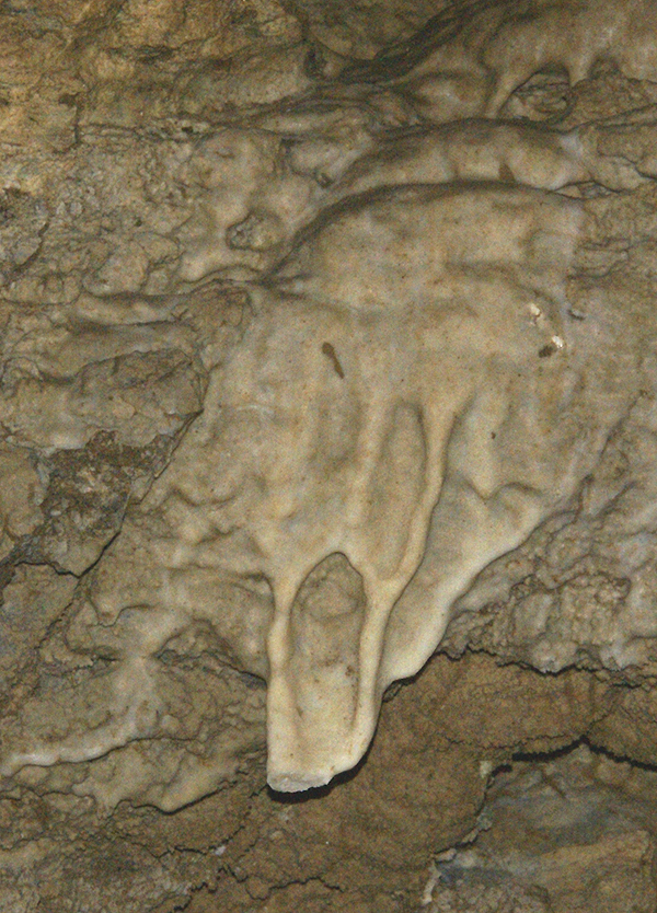
I can't remember much of Wind Cave, since I was there almost 40 years ago. Carlsbad seemed to have the least, although it does have an elevator shaft built in it, complete with stalactites growing in the roof of the elevator shaft. The worst damage that I can recall was in Lehman Caves. This was primarily because the caves were an entrepreneurial adventure for Absalom Lehman back in the 1920s. He let people literally go into the caves with sledgehammers so they could leave the caves with souvenirs. The damage was pretty evident in those caves.
The human damage was much less here in Oregon Caves although it was evident. We came across a rock where past visitors, from the 1809s felt it necessary to write their names on the stone in pencil. We walked right by the rock formation. It seemed obvious to many of us on the tour, that if the graffiti had been written in pencil, it should be fairly easy to erase it. Not as easy as it was thought however, because the cave is still a growing cave the pencil marks have since been covered over by a thin patina of flowstone. In other words, the graffiti has become one with the rock. The only other damage I noticed was a formation that reminded me of a painting by Edvard Munch entitled, "The Scream." At the bottom of the scream, there appears to be a piece that has been broken off.
This particular cave has gotten me to think about creating an earthcache. I found a nice spot where geocachers can observe some different cave formations. In the next week or 
The past week has seen me start back to school. We keep starting earlier and earlier. 14 years ago, my wife was pregnant with our third child, the Tadpole. His due date was September 12th, which was problematic at the time because that was my scheduled first day of school. Fortunately, I worried about this needlessly, because the Tadpole decided to make an entrance into the world 11 days early, so it didn't impinge upon my schedule. Look again though. September 12th was the first day of school in my district in 1995. My first day of classes this year was August 10th. Sigh. My apologies for not writing much this week. It was a busy first week.
Pictures were taken at or near the following future (hopefully) earthcache:
Oregon's Hall of Marble - by Webfoot

Saturday, August 8, 2009
Highway Character
For most of the week we were camping, we traveled along Hwy 101 in Northern California. The 101 is a very interesting road. Now 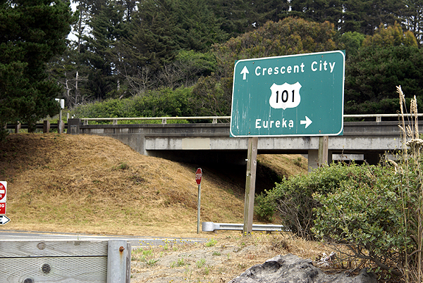
The 101 starts in Los Angeles as an 8 lane superhighway at one of the worst congested intersections of two freeways in the entire world. It is labeled an odd numbered freeway or highway. Usually, but not always, odd numbered roads run north/south while even numbered roads run east/west. There are always exceptions as we found out later on our trip when we were traveling almost due north on the southbound side of Interstate 5 in Oregon, but that's another story.
Anyway, the 101 is a north/south highway/freeway and starts in Los Angeles. For the next fifty miles it runs east/west along the coast, then veers into a 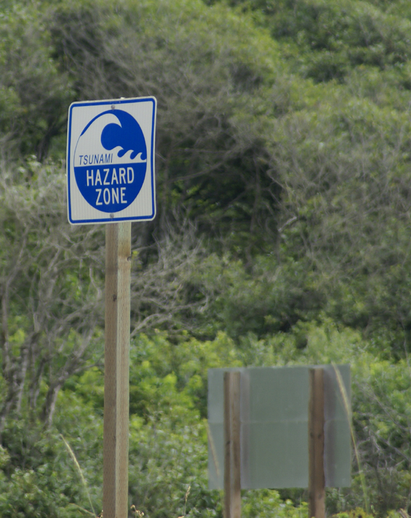
On our trip along the 101, we noticed all sorts of interesting things, most of which you don't normally see in your daily travels. How often do you recall seeing a sign along one of your highways indicating that you were in a Tsunami hazard zone, or that this was a Tsunami Evacuation Route? We noticed these signs every time the 101 came down close to the ocean, or was close to sea level even though it could be inland for quite a ways. This stems from the 1964 earthquake in Alaska which caused tsunamis to strike along the coast of Northern California, killing several people.
When was the last time you drove along your nearby highway and saw a statue of Paul Bunyan with a fifty two foot waist who stood next to a just as large big blue 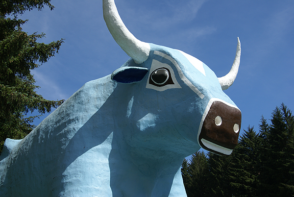
Wildlife seems to be common along many freeways and the 101 is no exception. The fact that it winds its way through a national park also increases the chances that when driving along the highway, you'll see wildlife. Having driving along the highway many times when I was going to college, I was prepared for the large herd of Roosevelt Elk we saw right along the road. I'm not sure the Tadpole was the first day, but by the third day, he was pretty much used to it. You just learn to drive slowly, so that one of those big 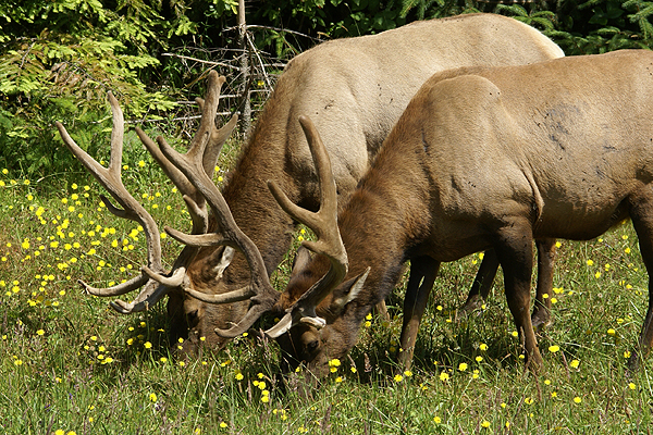
All of these encounters happened when the 101 was in two lane mode, in other words, in the more rural parts the highway wound through. The larger part of the road tended to be in the urban area. But that's what was really enjoyable about the road. No matter how big it got, it always seemed to go back to its roots, a two lane road, connecting point A with point B. A lot of these roads seem to be disappearing. I hope this road never loses its character.
Pictures were taken at or near the following geocaches:
Code by the Coast - by Phobos+Demos
Babe - by ChrissySkyking + Blaze
Big Critters With Antlers - by NCFLYERS - The Double J's of Fortuna, CA

Friday, July 3, 2009
Camping Trip
Planning has begun for our annual summer camping trip. This year there is a little bit of a twist to the entire trip, which is going to elongate it by about a week. Because of that, this will be the
 The pressing engagement on the far side of the camping trip was my older son's freshman orientation at UC Santa Cruz, scheduled for the 28. No matter what, if my dad came with us, we'd have to turn around about five days after getting up to Idaho.


Sunday, January 4, 2009
Billboard Jungle
The holiday season is over, yet my Christmas tree is still up and will probably be up for another week or so. This is not out of design. Usually, I take the tree 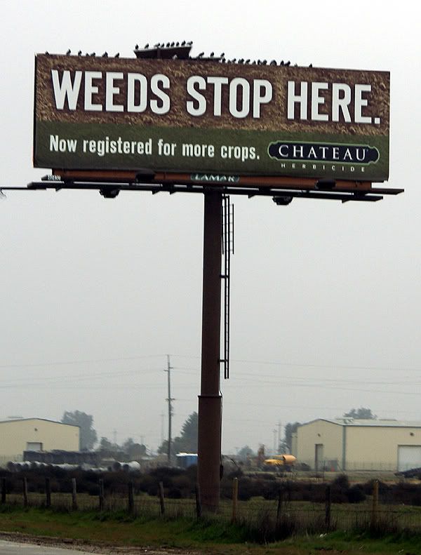
The road trip was rather uneventful. I drove, mainly because there was Tule fog in the big valley. It wasn't noteworthy or dangerous, and my daughter could have driven, but I like to drive. The last couple of hours she ended up napping in the car. What I really should have done was let her drive the middle two hours. But that didn't happen, so I was tired when we got to Stockton. She was actually amazed that I didn't stop even once to geocache. I figured since I was coming back down by myself, that I would get some caching in at that time, which is what happened.
On the drive up, I started looking at all the billboards at the side of the highway. Most of the time, I usually just tune them out, preferring to look at other things, abut there was something about this billboard that stated in no uncertain terms that "FOG KILLS" peaked my interest and I started looking at the billboards with a little more interest, at least for this trip.
America seems to have a seemingly unboundless interest in food. There were more billboards advertising restaurants than I could probably count, most of which were of the 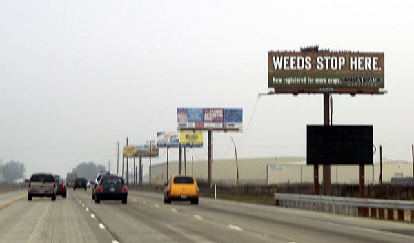
What seems less so, is the billboards that have websites attached to them. What was the designer of that advertisement thinking when they decided to put the website of their company on a billboard knowing that almost everyone that sees it will be driving by so quickly that the entire sign is almost a blur anyway? "Oh look Martha, there's a website address on that billboard!!! We should look it up right now and see what great information it has for us!" I can't even imagine a conversation like that ever happening, but there were several billboards that had the website addresses on them for everyone traveling on Highway 99 in the central valley of California.
Now there were just as many billboards that didn't have websites posted on them, some of which are pictured here. I actually think what got this whole thing started was the Weeds Stop Here billboard. My daughter mentioned something about posting a billboard about Marijuana along a highway as being possibly inappropriate, but then she realized that it was about stopping weeds in farm crops. I'm not sure why, but I particularly liked the Apple Annies signs, plus the FOG KILLS signs. Those just stuck out in my mind as we drove along the freeway.
Just for fun, I started looking at some of the billboards and then asked my daughter to write down some of the websites for later. One of the first catch phrases I noticed, besides the FOG KILLS was one by the California Farm Water Coalition. They 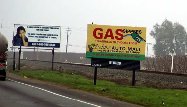
Besides telling us all that FOG KILLS, the FOGUniversity billboards also had a website to get more information about fog. The site is still under construction so there's not really a whole lot of information there except links to places such as CalTrans and the California Highway Patrol. There is a media link that has a short video about driving in the fog. Once again, Father knows best and is driving too fast, much to the chagrin of his child who warns him that he's driving too fast. It ends with an implied collision caused because of excess speed and fog. Now if he'd just listened to his kid in the first place. Tule fog is a very dangerous thing in the central valley of California and according to Wikipedia it is the major cause of weather related accidents in California so I'm not trying to make light of this as much as I am trying to understand why an organization would go to the trouble of putting up a website and then say, "Oh come back, we're not ready for you yet." I think it would make more sense to get the website up and running, then post the information on the billboards.
Another catch phrase that had me wanting to know more about it was the Check before you Burn billboards that were placed by 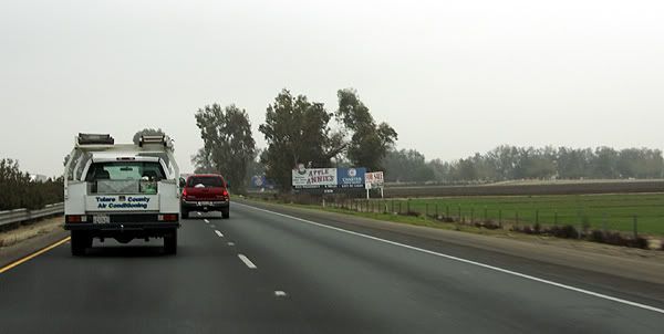
Several other billboards that contained website addresses catered to our stomachs or our palates. Cacciatorre Fine Wines has an interesting website. It has two buttons on its splash page, one for those of us who are over 21 and one for the younger set. I checked both out. The over 21 set get to go right to the main page of the website, while the younger set get directed to Disney.com. I'm wondering if Cacciatore Wines gets a kickback from Disney for this arrangement?
The second billboard that I noticed a website on that was strictly food related was the Valley Pistachio Country Store. It has a nice looking website with a variety of information about what the country store sells. It also has a Recipe of the Month section, although that appears to have just started around the holidays since there is only two recipes and both require the use of cranberries either to make Cranberry Pistachio Biscotti or Pistachio Cranberry bark.
The last two billboards that I noticed website addresses on were the Three Crowns billboard and the Pixley RV Resort billboard. I have to admit when I was reading these websites to my daughter, I knew what most of them would be, but I wasn't sure about Three 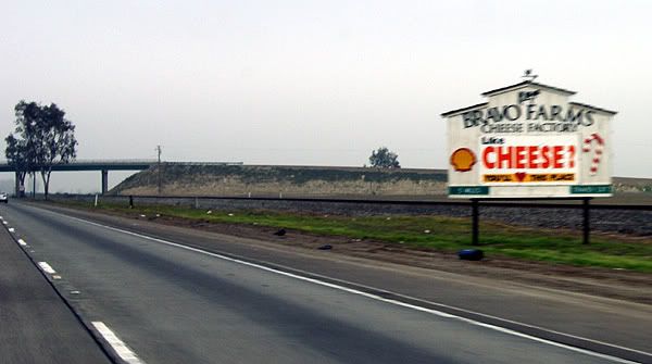
I guess the question I have for all these places is why. I realize that with all of our technology today websites are pretty much ubiquitous and a company that doesn't have a website is probably in the dark ages, but why post a website on a billboard? WiFi probably doesn't exist along the entire corridor however California does offer free WiFi at all of their rest stops. If the driver doesn't have a partner, it makes it unsafe for them to grab a pen and write down the website or even look it up on their Blackberry unless they pull over and that probably isn't the safest thing to do either along our highways as the shoulders of the road 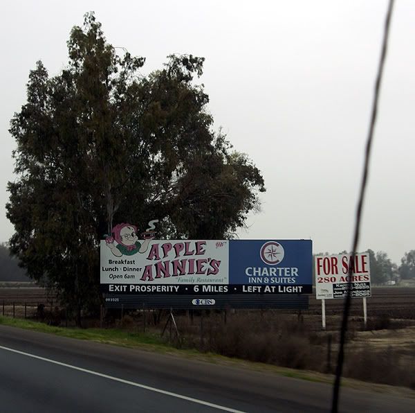
The logical explanation to all of this is the billboards are generic, designed for areas where people can stop and write down the website addresses. It's probably cheaper overall to make one set of billboards as opposed to two different ones, one for city areas and one for highways corridors. I'm not sure if this is a good thing or not, but I can visualize in the future where cars will have receivers to grab information off of billboards. Drivers will just have to push a button on their steering wheel and the car will automatically download the website address from the billboard. At the next rest stop, the driver will be able to plug his or her computer or Blackberry into the car's USB port and upload the information. Hmmmmm. I wonder if I can market this and make my first million in the next ten years?
Pictures were taken by my daughter along Highway 99 between Bakersfield, California and Stockton, California.


