Once again, September has become a slow month for me caching. However, in about a half an hour or so, I plan on hitting the road with my good friend Chaosmanor for some caching and GeoVexilla and also some GeoDashing. It's been a tough couple of weeks, so my apologies for not writing in here.
Showing posts with label GeoDashing. Show all posts
Showing posts with label GeoDashing. Show all posts
Saturday, September 11, 2010
September Slowdown

Sunday, May 2, 2010
Thanks Dave
In the spring of 2000, President Clinton signed an executive order allowing for the removal of selective availability of GPS satellites. The implications of this meant that hand held GPS receivers would be more accurate and navigation systems would start to become standard features in many cars. 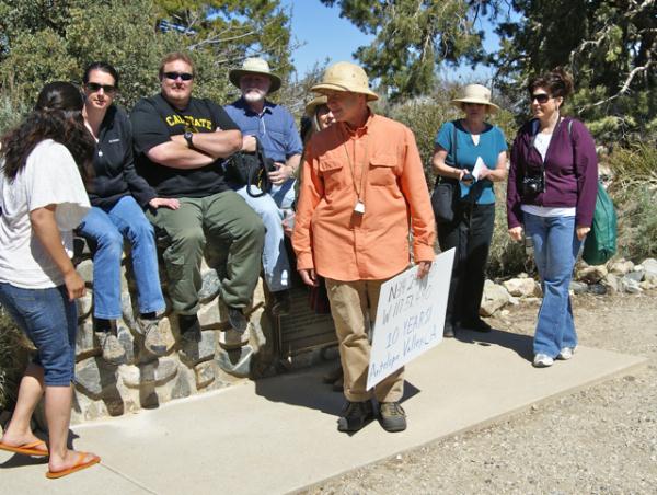
On May 3, 2000 Dave Ulmer hid a black painted container in the state of Oregon and challenged an on-line community at sci.geo.satellite-nav to go and find it. The first geocache was born, although at the time it was called the First GPS Stash. Within days, that first stash had been found. Contained within that five gallon bucket were a Delorme Topo USA and 2 CD Roms, a cassette recorder, a "George of the Jungle" VHS tape, a Ross Perot book, 4 $1 bills, a slingshot handle, and a can of beans. The original cache is no longer there, but the spot can still be visited where there is a plaque placed commemorating the original stash. The can of beans, heavily rusted but preserved, is now a travel bug.
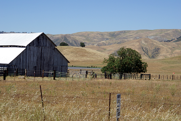
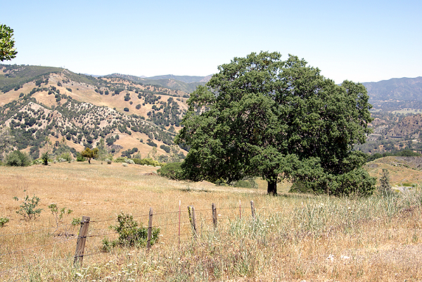
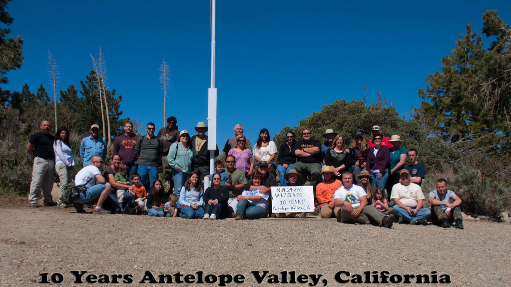
This weekend, I traveled to the Devils Punchbowl to celebrate ten years of geocaching. Events were held all over the world, but I found myself in a void, with the nearest event more than 30 miles away driving distance. I decided to attend the event in the Antelope Valley mainly because it's a very scenic spot, plus there were going to be opportunities for some hiking after the event. After all, when I started geocaching back in 2001, that's what it was all about. The requirements for a 10 year event, as posted by Geocaching.com were that the event needed to have a picture posted showing at least 10 people at the event plus a sign indicating the coordinates of the event in the picture. Our event picture is here.
This was my 9th event in just over 9 years since starting this silly game. I don't know why I don't attend many events. I could probably go to at least one event a month if I so choose, I just don't and there's not really a reason why I don't. This event, hosted by Kit Fox, was a lot of fun. I met one of the hiders of the Groundspeak Series and Smiley Series, Bigdaddygrc. I had a very pleasant conversation with him about geocaching and other things. I also spent a good deal of time with a fairly new cacher, HD-MsTree. I got to meet mcattk again, after bumping into him out at the Groundspeak Series a couple of months ago. Time was also spent with Yosemite John and Debbie and Tevis Clan. Several of us got a great review of Tevis Clan's new Lowrance GPSr. 
While on the hike we ended up bumping into several other cachers that had been at the event. W_bovine was walking down the trail from a multi-cache as we were heading up to it. That's w_bovine holding the sign in the picture. We had a pleasant conversation and I encouraged him to head over to my neck of the woods if he wanted to do some more hiking and caching. There aren't many hikers in my area, so my caches don't get found very often, so any new finders is a bonus in my mind. He said he would check it out. While on the hike, Chaosmanor and I discussed the different rock strata of the rocks in the Punchbowl, while figuring out the requirements of an earthcache along the trail. We also watched rock climbers playing their game. I'd tried that once when I was in college and made the mistake of looking down about halfway up a pitch. Never again. But then again, I would suspect that those rock climbers might think the game we were playing a little too mundane for them. To each his own.
At the end of the day, I counted my finds. Including the event, I found 8 - an event, a multi-cache, a mystery cache, two earthcaches and three traditional caches. It was a very modest day numbers-wise, but a very good geocaching day. It's not about the numbers of caches you find, but about the experiences you have as you play the game. I think I played the game well yesterday. Thanks Dave.
Pictures were taken at or near the following geocaches:
10 Years! Antelope Valley, California - by Kit Fox
Devil's Punchbowl - by Yosemite John and Debbie

Wednesday, July 8, 2009
Beach caching
Today, the Tadpole and I traveled down to San Diego. There was a Vexilla flag down there worth 8 points to me, plus a dashpoint, so we put the two together along 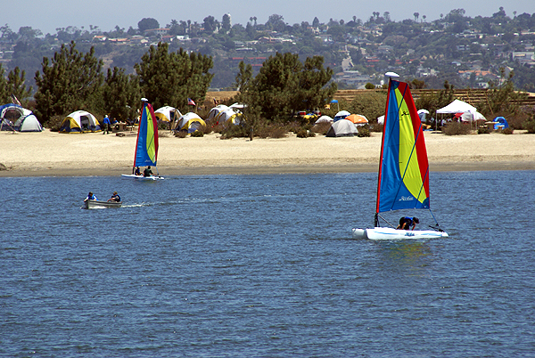
The flag find was an easy find as were the caches today, but the island was a neat little adventure. Each cache was hidden in a similar fashion usually under a bush, however there were a couple of variations. We even had one cache that was guarded by an attack lizard. Not really, but I spotted this lizard on a branch and as I was watching the lizard, I also spotted the cache about a half an inch away from the lizard. Unfortunately, I got to close to the lizard with my camera before taking the picture 
Fiesta Island and nearby Dog Island are all connected, so I'm at a loss as to why one island is named differently depending upon which side of the island you're on, but I have a speculation. At one point while walking over to find our second cache of the day, I looked at the screen and the mapping software in my Garmin had us in the water. Not just near a shoreline, but totally in the water for at least 800 feet in all directions. Now, when I looked around, all I saw was land, but my GPSr was saying there should be water there, which leads me to believe that the part we were walking on was water at one time in the not so distant past and it has been filled in, thus rendering two islands into one.
When I started looking at this island yesterday in preparation for the today, I noticed a series of caches that had been temporarily disabled. Apparently, there is a big softball tournament on this island in July and the attendees get kind of rowdy. The cache owner of this set of caches temporarily disables his caches, and does maintenance on them during the month of July, then puts them back out again in August. Which means that we could come down here again in the fall perhaps and there will be a bunch more caches for us to find. That's always a plus, especially when you don't end up finding a couple in a given area.
The day was pretty much picture perfect. The Tadpole got to enjoy a secluded beach and toss a couple of stone in the water. The sail boats were out in force. We
Pictures were taken at or near the following geocaches:
KITEBOARDING - by Splashman & Splashette
DRAGON'S FIESTA! - by DRAGONJD
GB #3 tanner_scout - by lulu499 and LegoCollin

Sunday, October 12, 2008
Forgotten Trail?
Yesterday, Chaosmanor and I hiked a loop trail in the Ronald W. Caspers Wilderness Park just north of San Juan Capistrano. It's a very large park and we were there primarily to get a dashpoint that had been positioned by the GPS Games computers near the north end of a couple of trails. 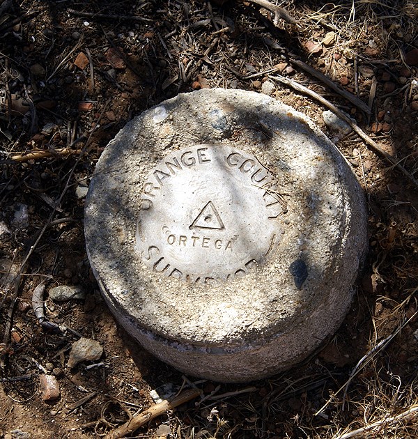
The trail we'd chosen to get to the dashpoint was called the Eastridge trail. It was a short hike up from what was called the Quail Run trail up to the Eastridge trail. We have views to the east of the Ortega Hwy and the valley that made up most of the park to the west of the ridge. Interestingly, there was only one geocache that we noticed along this trail. As we made our way over to this cache, we spotted a benchmark, or actually Chaosmanor spotted a reference post noting a benchmark, which was very close. The trail actually had a paint mark on the ground pointing to the benchmark.
This was one of those spontaneous finds. We hadn't really looked at the possibilities of there being benchmarks along this trail and we just happened to find this one. When I got home I was pleasantly surprised to see it in the Geocaching system. We took our requistite pictures of the dashpoint and then made our 60 foot walk down to where the geocache was supposed to be.
After about 10 minutes of searching, we consulted our PDAs and found the cache to have been DNFed back in November of 2007 and not found since before March 2007. Ground zero yielded a rather large packrat's nest, but nothing that looked like a decon container. We eventually expanded our range out thirty and forty feet, but couldn't come up with the cache. I posted a DNF last night and within minutes, the cache was archived. I think had we know the cache had some possible issues, we might have taken another route, but then we wouldn't have found that benchmark, nor the o
We started making our way north along the Eastridge trail commenting about the lack of caches along the trail. Chaosmanor brought a small container that we used down the trail to hide one cache, but there could have been quite a few nice caches hidden along this trail without even getting close to the cache saturation level. It's almost as if this trail had been forgotten by the locals here. Either that, or they're still working on it. I prefer the latter approach because you could say the same thing about the Claremont Wilderness Park near my house. There are still some great areas for caches, but I haven't gotten around to it yet. Eventually, as I'm sure the locals down there will do the same over time. It was just surprising to see this long trail with only one cache on it.
After Chaosmanor hid his cache and we checked (beta-tested) his coordinates, we continued along the ridge toward its northern terminus. At the junction of two trails at the north end we found another benchmark and a nice reference post pointing to the benchmark. We took our pictures of this benchmark, marveled at the nice view and noticed a game trail leading beyond the two trails, where it looked like another decent cache could be hidden.
The hike back down to the car netted us 5 well done larger caches, one very well cammoed that the Tadpole got to first. He was pretty proud of himself with that find because it was well hidden in plain site. Back at the car, the GPSr's internal odometer showed us we'd hiked 5.46 miles. It gave us a good workout as my calves will attest to this morning. Five caches found, two benchmarks logged, one dashpoint scored and a good hike with friends and family made it a very good day, one of those geocaching days that will stay with me for a long time.

Thursday, October 9, 2008
Surprising Results
Going to be heading down to Orange County to grab this particular Dash Point. We got lucky when the computer program for this month set that one up. It's in Ronald W. Caspers Wilderness Park very near a fire road trail, so it should be easily reached after about a two mile hike or so. I ran a PQ centered around that point and got the strangest looking PQ map I've seen in awhile. This is a pretty rural area but I was still expecting to see more caches along the Ortega Hwy. The arc to the west is in urban Orange County, but the nothingness to the east of the center of the PQ was surprising until I thought about it. The area to the east is pretty rugged and mountainous. I think I was surprised that there weren't more caches hidden along the Hwy. I guess we'll find out when we get there on Saturday. It could be that it's not safe to stop along most of the road. If you're not from this area, the grey area to the south is Camp Pendelton Marine Corp Base.
The Dash Point is in the center of the map and we'll be going for the caches located there. Most of them are along the trail and so they're not micros, but good sized caches. When the Tadpole found out about that, his immediate reaction was, "Score!" I have to agree with him. I'll be sure to take the camera along to get some pictures.
Another surprise was I couldn't find a public route query for the highway either, so I had to create my own. That wasn't too much of a problem. Just opened up Google Earth and asked for directions between San Juan Capistrano and Lake Elsinore. That gave me a route that I saved to my computer which I then uploaded to Geocaching.com. I put in some parameters for the route and came up with 69 caches along the route, most of which are centered around San Juan Capistrano and up around Lake Elsinore. There really aren't that many caches along that route. I've made the route public. You can search for it using keywords, Ortega, Elsinore or Capistrano.

Saturday, September 13, 2008
Secret Societies
One of the things I love about Geocaching, Geodashing, and Geovexilla is they're what I like to call "Secret Societies." My daughter and I play a game when we drive around town. I'll point a spot out and say, "You know, there's a geocache over there." Her response is always, "Did you find it?"  Usually my answer is yes, but one time it was no and she made me stop and find it. Good thing I had it in the GPSr with me at the time. It's a fun game we play, but then again, we all play it to some extent. Geocachers know there's secret spots out there that only they know about, so in essence, we do have a secret society.
Finding dash points or those virtual flags is very similar but maybe weirder because there's nothing there. The points and the flags are all virtual. One of the reasons I like the latter two is there's always going to be an air of uncertainty as to whether you'll be able to score the flag or the dashpoint. With geocaching, the hard part of determining whether you can enter a spot because of private property issues has already been resolved for you by the cache hider. Not so with the latter two. The points are randomly placed by computer, so there's no way of knowing whether you'll be able to score the flag or dashpoint or not.
Today, I went to my son's cross country meet in Laguna Hills in the O.C. My plan was to do some geocaching, plus score two dashpoints and a vexilla (virtual flag). The dashpoints were both relatively easy to score,  both being on driveways leading up to houses. Since you only have to be within 100 meters to score a flag or dashpoint, it was easy to park the car at the curb in front of each house and quietly write some notes about the area for my log on the Geodashing website. I'm sure the owners of both houses don't realize they have virtual points sitting in their driveways. Hey, it's our secret society.
There was also an American Flag that I thought about getting today as well. However, if you look at the satellite images for that one, you can see that it appears to be in a green belt area of a residential community. Not a problem? Yeah, but the residential area is in a gated community, so access is going to be difficult for this one. There's that uncertainty creeping in. I think it still can be scored, but I'd have to hike to it, something that I didn't want to do today because of a time crunch. There's a possibility that I might be down there again in the near future so I'll have to investigate it again at that time.
Interestingly enough, although I expected to find more geocaches than the other two combined, today was a total wash with caching. Not a single find and that was by choice. The two dashpoints were enough today. I'll have several hours before my son's next meet next weekend to find some caches. The pictures of my son running were taken last year at another meet down in the same area.
Pictures was taken near Dana Point T-bird - by devhead and somberairokid

Wednesday, August 20, 2008
Melancholy Road Trip
This past Sunday through Tuesday I was on a road trip. Knowing me, road trips cannot be a sad time, yet this one was a little bit, since 
We found four caches on Sunday, plus a virtual United States flag just west of Visalia. The PQ I'd run for this trip was heavy into larger sized caches because I had a dozen travel bugs that I wanted to distribute. Micros don't work well when you're dealing with travel bugs although I did find a micro on Monday that was large enough to hold a small travel bug. One cache was a virtual near the old city courthouse in Merced, CA but in all of the other caches we found, we dropped travel bugs. My daughter even found one of the caches. Now she would be the first to admit that she's not much of a cacher. She says she likes the idea, but doesn't have enough time to go out and look for them. But she was very excited when she spotted Preferred Cache and every time we mentioned to others on this trip we went caching, she made sure it was known that SHE found that cache.
Monday morning was devoted to unpacking the van. Why is it when ever you're moving someone, that person always has the room that is farthest from the staircase and is on the third floor of the building? 11 trips later, we had the van unpacked. My work was done. So I just sat in her room and logged my caches from Sunday while she unpacked all of her boxes and made her room a home. After lunch, I went caching while she decided that she needed to hang out with some friends.
The caching on Monday was very good. I found several large ammo cans in which I deposited more travel bugs and I also nabbed two more virtual flags, getting Argentina in the back yard of a farm near Wilton, CA and the red and white banner of Canada which was virtually placed on the top of a red and white storage shed in the garden center of a nearby 
Tuesday, it was time to start my travels home. I woke up, showered, went to breakfast, then dropped by her room again, said good bye to her and went back to my hotel, packed and drove home. Although we view this house as home, it dawned on me yesterday that Pacific is her home. She was in her element there and it was really fun to see the change from last year where she really clung to us and hung back, not wanting to get too far away from either of us during parent/student orientation. T
So the trip home was sad, but I enjoyed the solitude. The caching was enjoyable Tuesday as well. I chose a different route going home because there were a couple of dash points that I wanted to get, so I took Hwy 99 for the first leg, but diverted to Hwy 41 south of Fresno, connecting eventually back up with Interstate 5 at Kettleman City. I got the two dashpoints plus some more caches along this route. It was a good day to be alone with my thoughts as I pondered what it will be like next year, when I help two kids off to college. I listened to a CD that she burned of oldies and some of her music on the ride. 
Pictures were taken at or near the following geocaches:
Fig Tree View - by Oldhippy & Granny
A Walk to Remember - by George and Mary
Wilton Memorial Rose Garden - by DiaU
Red & Green's Travel Bug Hotel - by Delawares Blue Hen Chicken
The Grangeville Zoo - by Great Scott!

Monday, August 11, 2008
Discrepencies
It's interesting how different GPS units measure the same information. This past Saturday, my friend Chaosmanor and I went out 
The first dashpoint we attempted, our GPSrs were agreeing with each other almost down to the smallest detail. The picture of our two GPSrs are each pointing at the rock in the center between the two. When they were placed down, they both read zero. After we had taken our pictures and notes, we looked at the GPSrs and they were both pointing at the rock and registering 1 foot away.
Surprisingly, later in the day, at our last dashpoint, the closest we could get to one another while trying to zero out on the point was about 25 feet. We've noticed similar things on other caching trips we've taken, but usually it's a difference between makes, the old Garmin vs. Magellan type of thing. Saturday's discrepancy was between different models of Garmins. I have a eTrex Legend C and his, I
Pictures were taken out in the Antelope Valley near dashpoints:
GD86-AKAP
GD86-AKOR

Wednesday, August 6, 2008
Best laid plans
"The best laid plans of mice and men often go awry." This line, adapted from To a Mouse by Robert Burns best describes our camping trip. Yes, we're home already. Monday morning broke cloudy and humid as the monsoon season that we so typically get in Southern  California seemed to have arrive. I thought to myself as I went to get the paper, great, we'll be getting out of this and moving to a little bit cooler climes. We ate our breakfast, gathered up our last minute incidentals that still needed to be in the car, said our goodbyes and were on the road before 8:15 in the morning. We encountered some traffic along the 210, so we decided that we would forgo our first Vexillum flag of Haiti that was located in the San Fernando Valley and just headed off toward the Grapevine.
The rest of the drive up the I-5 was rather uneventful, although there were clues to what lay ahead. For lunch, my wife had prepared a nice sandwich for each of us. The tadpole took about three bites of his sandwich and about two sips from his juice can. I should have thought about that since he's starting to eat like a horse, but I've seen other trips where he doesn't eat much on that first lunch, so I really didn't think much about it.
After crossing over to the coastal valleys via Hwy 152, we reached our first waypoint, another Vexilla flag, this time of Barbados. The farm land was typical for the area around Gilroay and Hollister, alternating with groves of trees, most likely almonds, with corn and then pasture lands for cattle. The flag we were seeking happened to be located in a cattle pastureland. We couldn't go all the way to ground zero, but we were close enough to score the point for the flag. Being close to Gilroy, which bills itself as the "Garlic Capital of the World," we couldn't help but notice the pervasive smell of garlic in the air. However, even my son, who loves garlic, balked at the advertisement on the famer's market stand on the road which advertised Garlic Ice Cream.
We then made our way north along Hwy 101 towards San Mateo County. Once entereing San Mateo County we started actively looking at the GPSr to find a cache that we could find and log. We eventually found a very nice ammo can on a ridge overlooking I-280 on one side and the San Andreas fault zone on the other side. We then got back on the freeway and made our way to the very next exit which was a rest stop. As I got out of the van , I noticed another cache here, so we found that virtual as well, learning a couple of nice things about some of the missions in California.
Then we headed up to San Francisco, getting a dashpoint near the San Francisco zoo and a virtual in the heart of the city. The city's finest elements appeared in all there glory while on this trip through the city and the Tadpole marveled at the different kinds of people there were in the world. In a car in front of us at one point, there was a passenger who had, at minimum, an 8 inch Mohawk hairstyle. I'm not sure either one of us were ever able to determine whether this said individual was male or female. Not that it mattered, it just added to the overall story.
San Francisco was living up to its reputation weatherwise, being very cold and cloudy. The tops of the highest skyscrapers were shrouded in fog as were the tops of bother towers of the Golden Gate Bridge, yet you could look across the bay and see Alcatraz Island, basking in sunlight. We continued north, making a turn at Hwy 1 to get out to the coast on the Marin County side of the Golden Gate. That's when I started noticing more problems.
The Tapdpole, who rarely gets headaches had one and was rather pale. When we got to camp, he perked up a little bit and I attributed it to the winding road and a little car sickness. After a hearty dinner, which he wolfed down and setting up camp, we decided to try and find our first cache in Marin County. The closest one to our campground, we ended up not finding after two tries at it. The night was upon us and we headed off to sleep.
I awoke with a start around midnight trying to figure out why. The Tadpole was moaning and I was able to get out of him that  he didn't feel good. I went to get a bucket, just in case and his response was, "Hurry." A couple of minutes later, dinner made a resverse entry from him. Four hours later, he finally had heaved the last amounts of dinner out of his system and was finally asleep. The morning didn't seem to bring much relief to him. He insisted that he wanted to go out to the Point Reyes lighthouse, but as we made our way out there, I could see him fading fast. We both made the decision that it would be best to come home, because it didn't look like he was going to get much better over the next day or so and it's miserble enough being sick when you're at home, let alone in a strange place. So, we're home. He's probably about 90% or so right now and another good night's rest at home will probably bring him back up to full speed.
So that's why we're home and not still out in the woods somewhere. Point Reyes is beautiful, and both of us agreed that we'd like to go back there again next year. So that's what the plans are at this time. Like a proverbial baseball team that has fallen short, "We'll get 'em next year."
Pictures were taken near Gilroy, CA, Samuel P. Taylor State Park and Point Reyes National Seashore.

Sunday, August 3, 2008
Happy Trails
And away we go. The van is packed and except for a few incidentals that we need to pack in the morning, we're set to go on our week long camping trip up the coast of California. After looking at the GeoDashing site and the  GeoVexilla site we have the possibility of getting upwards of 16 flags and dashpoints on this trip. Although the flags are a one time shot for this trip, I will be heading back up to the Stockton area about a week after I get home from this camping trip, so if I miss a couple of those dashpoints due to time factors, I can always get them when I take my daughter back up to school.
For Geocaching, I ran the PQ on Saturday. After looking over the puzzles I solved 6 of them very quickly. There are three others that will have to be solved in the field because they depend upon signs and plaques to get information from to solve them. As you can see by the map, the route is a little convoluted, but it's pretty much the way we'll be traveling, heading up the coast on Monday, then further north on Wednesday after a stop near Point Reyes National Seashore. I have a geocoin that commemorates the Cape Hatteras Lighthouse and it wants to visit other lighthouses, so I have a good opportunity to help it toward its goal. There's also another lighthouse up near Crescent City where we'll be camping that I could take it to as well. After visiting the Point Reyes area, it's on to Redwood National Park. All in all, it looks to be a fun trip for the two of us.
One of the caches that we definitely want to find is Rabbit Eye View. If you look at the graphic, I have it highlighted. You can also see it highlighted on the map in a semi-pink color just north of the San Francisco area. It's one of the four caches with only a two digit GC number, meaning it's a very old cache, one of the few caches that have been around longer than I've been caching. The other reason for us to get that one is there is a special cache inside that cache. The Fly....Mars Rover moving cache is inside the Rabbit Eye View cache. Moving caches aren't allowed anymore by  Geocaching, but there are a couple that are grandfathered into the system, this one being one of them. I've had this particular one on my watchlist for a very long time. It's been all over the place, then found its way to California, then back east and then was brought back out here to the GeoWoodstock Event in May where it's been seen in many caches around the Bay Area in California. Now it's up in Bodega Bay, where we'll be on Tuesday. I posted a note on the Mars Rover page that hopefully will keep it there long enough for us to grab it, or at least find it and log it. That would be a really cool find.
One last goal that we have on this trip is try and find at least one cache in each county along that mapped route. If that happens, we'll add 16 or 17 new counties cached in for California. That will put us that much closer to reaching the goal of having cached in all 58 counties in California, which will help us also find the California County Challenge cache. That won't happen this year, but we might finish that goal by next summer.
I don't expect to be able to post any followups while on the road. I am taking my mini lap top with me, but I'm not going out of my way to find a WiFi hot spot so I can log caches or post to the blog, etc. What happens is what happens on this trip. We're expecting to commune with nature, find some ammo cans and tupperware in the woods and go on some nice hikes. Until the 11th or so, I'll see you later.
Wednesday, May 21, 2008
Backroads
This past weekend I drove up to 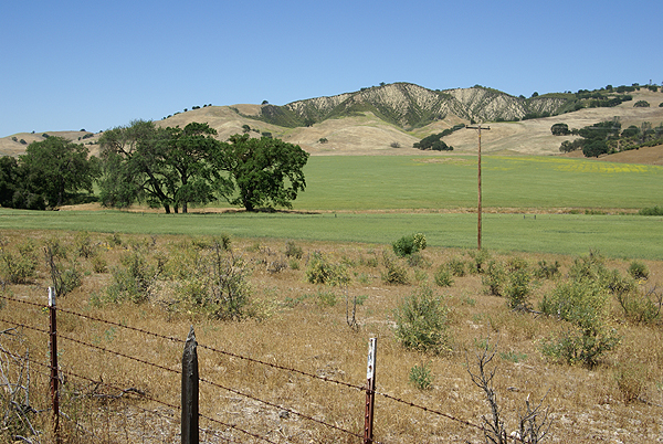

And sorry I could not travel both
And be one traveler, long I stood
And looked down one as far as I could
To where it bent in the undergrowth.
Then took the other, as just as fair,
And having perhaps the better claim,
Because it was grassy and wanted wear;
Though as for that the passing there
Had worn them really about the same.
In leaves no step had trodden black.
Oh, I kept the first for another day!
Yet knowing how way leads on to way,
I doubted if I should ever come back.
I shall be telling this with a sigh
Somewhere ages and ages hence:
Two roads diverged in a wood, and I--
I took the one less traveled by,
And that has made all the difference.
Pictures were taken at or near the following caches:
A Green Valley View by Sloigo
Old School by Pal_Al
Stop Staring at Me! by Momaqna
Take a Sit by Scooterman
Are we there Yet III? by Sloigo

Sunday, May 11, 2008
Scouting
I've been rethinking my geocaching goals for the year. A couple of years ago, I wanted to average at least one cache find per day for the entire year. I did that very easily and almost averaged 2 caches per day. 
I guess what I'm really coming around to is that I'm thinking about getting back to the roots and looking for better hides as opposed to just going out and caching for caching sake and having that end up being just another numbers run. I want to try and get some more hikes into my caching repertoire this year. So I'm starting to scout out some areas that I haven't been in before to look for some possible hikes with caches.
Yesterday, the Tadpole and I went out into Riverside County to look for a dashpoint, actually two dashpoints. I ran a caching PQ around the second dashpoint which was out near Menifee in Team Hick@Hearts neck of the woods. I had considered emailing him to see if he wanted to come along, but then I remembered that he was planning on hitting the Flash Mob event down in San Diego. After Saturday, we'll probably be out many more times, so another oppotunity will present itself in the near future I'm sure.
At the first dashpoint, we struck out, getting only .18 miles from the point, not nearly to the magic 100 meters needed to claim the point. The point was located in the middle of a major trucking facility and there was no way in to get close, unless we wanted to trespass and risk prosecution. Nah, I don't think so. My sense of adventure isn't that high, especially when I have the youngster with me and he's probably going to be learning some life lessons any time he's with me.
So we headed out to Menifee, where I knew the dashpoint was a drive by. I wanted to see how close we could get. It was located near a road, but on the other side of a railroad right of way. We got to 73 feet, so we scored that one. The pictures are nothing to write home about, but it was nice and quiet out there. There were a couple of nearby caches, so we got those. The second one was probably the most memorable one of the day, being the only ammo can we found. As we were walking up the short trail to the cache, the Tadpole was ahead of me and I warned him to be on the lookout for snakes.
The trail split and he went one way around a bush and I went another way. We were about at ground zero at the time, so we'd both stopped to begin our search when I hear a "Whoa!" I asked him what's up and he just nonchalantly states, "Oh nothing, just a big snake in the trail up here." For a twelve year old, seeing his first "in the wild" snake," he was really cool about the entire encounter. I told him to back up and I came around. By that time, the snake figured that two of us was probably one too many, so he slithered off into the nearby bush. He was a fast booger too. I just caught the tail end of his act, but the Tadpole saw the entire two to three foot snake in the middle of the trail.
Fortunately, it wasn't a rattl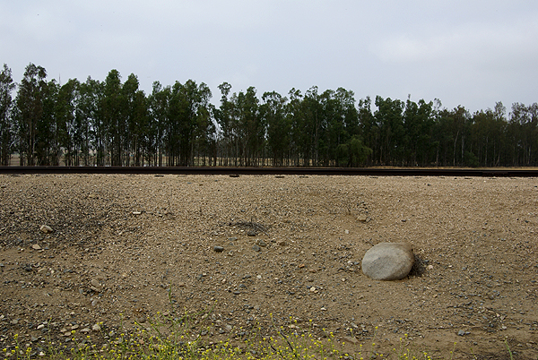
We drove back home, finding several other caches in the local area, none of which were anything out of the ordinary small to micro variety of caches, but we did end up finding a nice trail that looked to have some caches up on it. It was getting toward lunch time, the Tadpole was tiring quickly and I hadn't been prepared for a hike of any magnitude, so we passed on them today, but as I look at the map, there appear to be about 23 caches spread out on a couple of hills. If the weather holds, I might convince the Tadpole to come out on Memorial Day, or possibly I can convince any of my other caching friends to either go that weekend, or possibly the next weekend. It's getting late in the season to go on something like that, but if the "May Gray" or the "June Gloom" holds, it'll work. If not, I can keep that trail in the back of my mind for a fall or winter hike. I'm sure the caches will still be there, unless a fire goes through.
Anyway, the first scouting attempt turned out fairly well. It looks like a good trail, with several good caches on it, with a nice hike to boot. Reminds me of my first caching experience - 7 miles away and a half mile hike.
Pictures were taken near the following cache:
Jack's Cache - by jeepnakd

Wednesday, May 7, 2008
Future trips
My last road trip was a three day affair back in February to visit my daughter at her school. I’m heading back up there for another shorter road trip in 10 days time, to pick her up from school. I tell you it’s not fair. 

Carson Hill: A Very Historical Place - by tmkbk & olympicwannabe
Beam Me Up - by Ktquilt
Mariposa History - by halfdome and shortcircuit
Mr. Mother Lode - by Uncle Al from Sacramento

Sunday, May 4, 2008
Solitude
Yesterday, I got to experience something that rarely happens to most human beings, that rare time when you are by yourself and you're all alone as if you're the only person on the face of the earth. Granted, I was with my friend Chao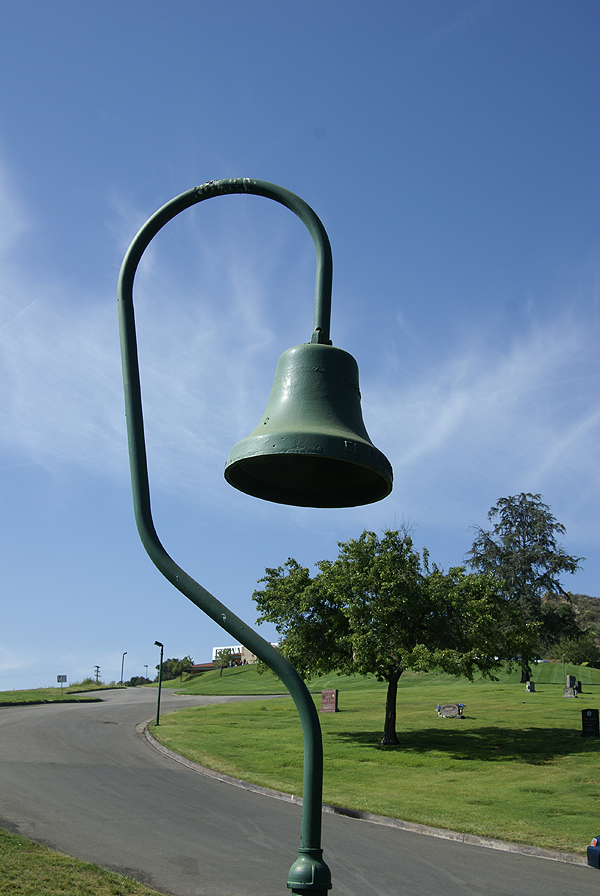
With my introduction into new GPS games, we both decided that a road trip up into the high desert north of us was in order, so we set out on a 322 mile road trip yesterday, making an entire loop around the San Gabriel mountains. We started out in Pasadena and took Highway 14 north toward Palmdale, stopping a couple of times to grab a cache, plus a couple of virtuals as well. We saw an old bell from the old El Camino Real, the King's Highway at one of the virtuals. We were also trying to get several flags in the GeoVexilla game, plus a couple of dashpoints for GeoDashing as well.
Most of the morning was spent caching. I got my 1900th find on a nice travel bug hotel just off Highway 395 which runs through the desert and east of the Sierra Nevada mountain range all the way into Washington State. I'll have to keep that particular hotel in mind the next time I head on vacation up that way as it's an easy on and off and great spot for a travel bug hotel, without any of the silly "take one only if you leave one" restrictions that some bug hotels have on them. Those are prisons, restricting the travel of the bugs, but that's an entirely different post.
After lunch at the local nationwide hamburger place, we decided to get some flags and dashpoints. Our last dashpoint of the day took us out northeast of California City, which is a huge city (land area-wise) out in that part of the desert. Google maps says that the city is east of where we were looking for the dashpoint, but in re
The interesting thing about Geo Vexilla and GeoDashing is there is a certain degree of uncertainty about each hunt. It's similar to Geocaching, yet there still more uncertainty, because you never know what you might run into when you're on the ground, even if you have really good Google Satellite images to look at. The detail of those can only be so good. With Geocaching, you know that at least one other person (the hider of the cache) has already been out there. In Dashing, the likelihood is, no one has been out to this particular spot before, so it's all new territory to discover.
This is where the solitude comes in. The roads out in the desert, for the most part are dirt and you can only go so far before your smarter senses take over and you realize that you need to park the car and walk, otherwise your car and you might get stuck. I do not own a four wheel drive vehicle, although I freely admit that it's one of the many toys that I've lusted over in the past couple of years. So I was taking no 
We knew the solitude had to end, because we had to get back to civilization. On the way back to my car, we started seeing different kinds of insects, plus a couple of birds. It was almost as if the animals wanted us to share in their solitude by being absolutely still for us on our trek out. Or was it the other way around and we were intruding on their solitude? Either way, the solitude was broken entirely by the time we got back to our car, because at about that time, a dirt biker went flying across the desert on his bike, on one of the many trails that criss cross in the area. So much for that quiet solitude, but it was nice while it lasted.
Once back in the car, we headed back toward civilization, finding a couple of other caches along the way. I spotted a partial California Desert Tortoise shell. It was a very large shell. I estimate the carapace was at least 12 inches across. I have a couple of these guys in my back yard (they are permitted as per law) and they're not nearly as la
Caching and hiking in the desert always seems to bring out new experiences for me. The vistas are always impressive although it was disconcerting to see the Los Angeles smog creeping out there. The view was a little bit hazy as a result. It looks like we missed the peak blooming season for wildflowers out in the desert by about a month, be we were still able to catch glimpses of mesquite in bloom as well as some desert mallow. All around you, there is life, even in the most inhospitable places like out here. And in the back of your mind, 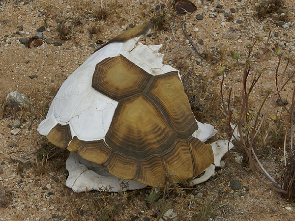
We made our way down Interstate 15, through the Cajon Pass and then skirted the San Gabriels on the south heading back toward Pasadena where Chaosmanor's car was parked. The trip down was a little quieter, perhaps because we were being a little bit more introspective after our trip into the desert. I'm willing to bet that it was really because we were both tired, more than anything else. It was a good day.
The first and last photos are from the following geocaches:
Pioneer Cache - by AlphaCat with help from The Boy and CC-Cat
Ma Greens General Store (Formerly) - by Team Berge (Thanks Ma Green)
The other pictures are from the Dashpoint out in the desert near California City. Thanks to Chaosemanor for taking a picture of me at ground zero of the Dashpoint.

Subscribe to:
Posts (Atom)
