In November, Los Angeles gets treated to the annual U.C.L.A./U.S.C. football game. An old saying I've heard in the past was, "On a clear day, U.C.L.A. . . . . . . . . on any other day, U.S.C. Obviously, this one was created by a Trojan fan, but if this past week is any indication, U.S.C. might be in trouble this year. 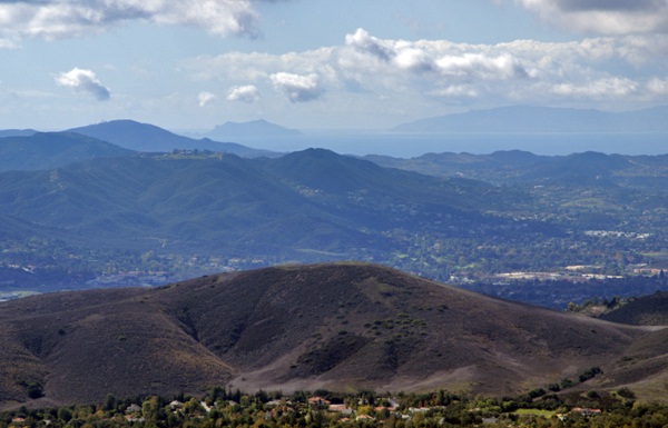
Last Saturday, I went on a hike with my friend Chaosmanor in the Agoura Hills area of the Los Angeles Basin. We'd planned a trip to get us several geocaches, plus a virtual flag that would score me the maximum number of points in the game. We found several caches before heading up to the trailhead to begin our hike.
The first part of the hike was on a new trail open for about a year or so. Surprisingly, it had no caches on the trail, so Chaosmanor took it upon himself to hide a couple while on our way. Soon after those hides, we were on a fire road heading up to some caches that hadn't been found in exactly a year. Well, they still haven't been found. One cache we started to attempt, but didn't finish, mainly because the terrain had changed slightly in the past year. There was a lot of plant growth, which concealed the main way up to the cache and any other route that we could see, looked extremely treacherous and so we passed on it.
The second cache was similar, so we didn't even make an attempt to get up to it. The third cache was attempted after a nice lunch at the end of the fire road on which we'd hiked. This one was probably the most frustrating of the three since we were able to hike up to the cache site and do a very thorough search of the area. After calling a lifeline, we were pretty much able to verify where the cache probably had been, but we couldn't find the ammo can that had been placed there. 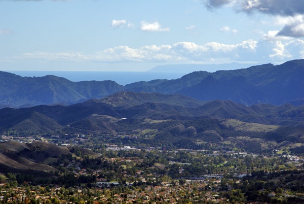
After striking out there, we headed further up along a game trail and found another more established trail that took us up to the virtual flag and a couple of other caches, including a virtual cache at the top of Simi Peak, just inside the Santa Monica Mountains National Recreation Area. This stop was probably the highlight of the day.
The peak is only 2403 above sea level. I was able to verify that with a laminated sheet at the peak. I put my GPSr down next to the sheet and eventually, it also read the same elevation above sea level. Just after I took the picture, the elevation on my GPSr changed again. I've noticed that on other occasions as well, so I'm not ready to say that my GPSr has great accuracy when it comes to elevation, just that I was able to get the two numbers to coincide.
That didn't make the highlight reel though. What made this spot truly noteworthy was the view. Even though we were at fairly low altitude, we had a complete 360˚ view which stretched for miles and miles, literally. Originally, I had been looking to the west from the peak. Chaosmanor had already pointed out the ocean from further down, but once we got on top of the peak, we spotted Anacapa Island and behind it, Santa Cruz Island, both within Channel Islands National Park. Looking at the map, it looks like we were at least 30 miles, probably more distant from those two islands.
Then we got a bigger shock, I believe, when we looked south and could see the ocean and Catalina Island in the distance. 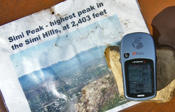
The weather conditions were just right that day where we were. Other hikers might not be so fortunate, but hopefully, that won't stop them from coming up there. I can imagine that peak in fog. That would give an entirely different perspective to the area, that's for sure. We spent a great deal of time up there, getting the necessary information to fulfill the requirements, take pictures of the scenery, take pictures of the benchmark that's also at the top and also just to enjoy the view. It's not often that the Los Angeles area is that clear. Besides the ocean views, we also had amazing views of Simi Valley to the north and the San Fernando Valley to the east. It was a picture perfect day.
Eventually, we knew we'd have to descend back into civilization and we did it reluctantly. We hiked down the trail heading to other geocaches further down the slopes of Simi Peak. At one point we missed a trail junction and ended up further north than we had originally anticipated being, so that added another mile or so to our overall hike, but it was definitely worth the effort. It had been a good climb up and a good hike totally just over 8 miles. It had been a good day.
Pictures were taken at or near the following geocache:
Simi Peak Returns - by WM6P
Friday, November 5, 2010
On a clear day...

Monday, November 2, 2009
Capture the Flag again
This weekend was a very enjoyable weekend. My first trimester of school ended and because I had all my grades already done, all I had to do was bubble in the grades on our computerized form and turn them in this morning. 
Saturday morning, early was devoted to rounding up all of the electronic equipment that either didn't work any more, or had outlived their usefulness in our household. My wife's school was having a free e-Waste disposal that day, so it made for an easy and cheap way to get rid of a couple of excess monitors and other electronic stuff that had been sitting around the house for awhile. After that, I decided to go out and find some virtual flags.
Some of you know that GeoVexilla is a virtual flag game that places random international flags virtually around the globe. Each time you get within a 100 meters of a flag you score points for that flag. When you find a flag, you generate a new set of five flags. The first flag is worth 1 point, the second 2, the third 4, the fourth flag is worth 8 and the fifth and final flag is worth 16 points. 
Two of the more interesting spots I found flags was on the top of a mini-mall in Long Beach. The flag of Belize was perched on top of the roof of a Bristol Farms store. I couldn't quite zero out on that flag, but was able to easily get within 100 meters, so I scored the one point. That was the first time I've found a Belize flag, so it generated a set of flags for me. Because of other flags that I've found in the past, I was able to move flags around and actually fill out the entire set that this particular flag generated, which gave me 31 points for a full set. Of course, since I moved flags around, that created gaps in other sets, but I'll eventually fill those in as time goes on.
Another flag that I found this weekend was a Columbian flag which was flying high on a ridge overlooking an avocado farm near Temecula, CA. I was able to take roads through an organic avocado farm, then walk up a short paved trail/road to get within scoring distance for this flag. 
That's one of the nice things that I enjoy about this GPS game. Because the flags are randomly generated, there's some unknown quality built in to finding the flags. It's not like geocaching where you know someone has been there. With this game, it may not be possible to access a point, because of private property laws, or other restrictions. Sometimes they end up being placed by the game's computer in the middle of a wilderness area with no accessibility. Just in the last day, a new Bahamian flag has shown up in the Long Beach harbor. It looks like the only way to score this one would be to take a boat into the harbor and sail over to the point. It's the randomness that makes this game fun.
Pictures were taken at or near the following virtual flags:
VX39-UDOD
VX39-UVAS

Tuesday, May 19, 2009
The Answer My Friend.....
This past weekend, I did a quick turnaround trip up to Stockton to pick up my daughter from college. I'm just recovering from the trip, but then again, most of us who are slightly older know what a 1000 mile round trip 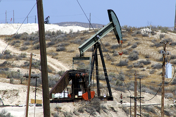
Driving up, I decided to take the back roads, although they weren't necessarily the most scenic. There were several virtual flags just off the Interstate that it appeared that I could get close enough to, so I routed to those and also did some caching. Consequently the trip up took about four hours longer than usual, but it was an enjoyable extra time. Driving, then getting out and caching for a little bit tends to help keep me refreshed for the drive to come.
The side trips took me through the oil fields in the southern central valley around the town of Taft. Nothing really spectacular about this area, although I did get a little bit of a jolt at one cache. It's definitely heating up in the central valley and summer is upon us. The drive home, I noticed a time and temperature sign in Bakersfield that read 106°. Granted those 
The cache that I found near Taft hadn't been found in over a month. Apparently, the seal on this particular ammo can was a really good seal. With the heat of the sun beating down on it, the insides were very warm and I have to theorize that the air pressure inside it was slightly higher than the outside. When I popped the handle on the ammo can, the cache hissed at me giving me a little bit of a start. This was one of those moments that I was glad that I had been caching by myself, because I know I jumped, which would have probably caused some laughter from any caching buddies that would have been along for the hunt.
Later on in the day, after getting back over to the Interstate, I took my second side trip, this time into the San Jose area, which is near the southern part of San Francisco Bay. Once again, I was looking for a couple of virtual flags and a couple of caches. The one cache that stood out in this area was a kinetic sculpture. While waiting at the light to turn into a business complex, I noticed the sculpture from a couple hundred feet away.
A quick glance gave me one of those, Oh, OK. That's kind of interesting. When I looked again, I noticed the sculpture had changed. Now this was interesting. Once I got up close to it and had parked the car, I realized the sculpture was two large panels that swiveled at their midpoints. They would wave back and forth with the wind, not a lot, but enough to get a different look every time you looked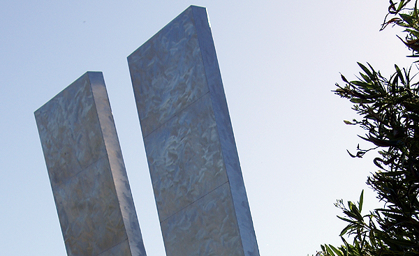
There wasn't any explanation, except who created it and what the name of it was, but I would have liked to know how much the panels actually fluctuated in the breeze. There was a gentle breeze blowing that day, but I wonder what the panels would do in a brisker breeze. We get gale force winds down in Southern California from time to time and I would imagine that can happen in the Bay Area as well. I guess, I'll just have to come back up here some time when the winds are really blowing to find out.
Pictures were taken at or near the following geocaches:
California's Other Gold - by feedle
Silver Gyrations - by N2Books2

Monday, March 30, 2009
Desert Color
I think most people think the desert is pretty barren. I've always found it anything but and during certain times of the year, it can be pretty spectacular. Sometimes,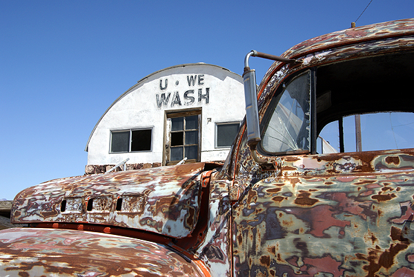
When I was out in Shoshone this past week, I found several caches that fit the bill for different types of color. One cache was hidden outside a broken down laundry facility near a campground. The campground was situated on top of a dry lake bed, which, for the most part makes it pretty barren. The laundry facility was built up on top of concrete blocks. It was a permanent building, so during times of rain in the desert, it would stay high and dry above the lake that would form after a good rainstorm.
The facility is in disrepair now, but there was an interesting old truck outside of the place. It had the neatest color composition, sort of a combination, primer, rust, old paint all blended together for some kind of surreal pop art type of vehicle. Looking at the tires, they were low, but it looked like the truck hadn't been parked there very long and could conceivably still be driven. I think it would definitely turn some heads if it had been taken for a spin. Out in the desert, it looked right at home.
At another spot I found a cache near an old cemetery that appeared to be still active. I've always been one to look at old cemeteries when 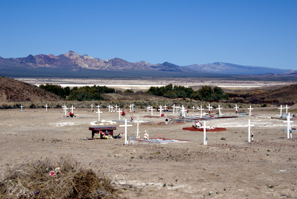
Many cemeteries in the desert tend to be located in very peaceful spots, usually with good views and this one was no exception. I remarked in my log that this particular spot would be a bad spot to spend eternity, since it had a view that was absolutely gorgeous. Although, I also noted that it wouldn't hurt me a bit if I had to wait another 40 years before I decided to take up residence in the place.
Then on Sunday, the Tadpole and I went caching in the high desert just west of Victorville. We were 
My picture doesn't do it justice, but I loved the way the ground was covered in yellow, while I could still see snow on the mountains that separated the high desert from the Los Angeles basin. In a few short weeks, this natural carpet will be gone, withered away as the temperatures start to climb to three digits. But all the seeds these flowers produce will support another natural carpet next year after the rainy season has concluded. We just got lucky this year that we happened to be in the right place at the right time.
Pictures were taken at or near the following geocaches:
Tecopa Wash-Up - by Mr. and Mrs. Rhino
Cemetery Cache - by 3blackcats
4474 - by Mr. & Mrs. Wisearse

Wednesday, March 18, 2009
Tucked Away Treasures
After dropping off the two travel bugs near Disneyland, the Tadpole and I headed south into Santa Ana. We had two reasons for heading that way, the first being a virtual flag just around the corner from one of the elementary schools I attended. Amazing as it may seem, we didn't move once after my parents purchased the house in south Santa 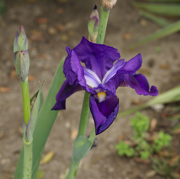
Unfortunately, I might not score any points for this flag. The GeoVexilla site has been down for almost a week. The map shows up on the main page, but no flags do. One of the other game players kept a daily database of all the flags and sent me a spreadsheet of all the flags that were within 100km of my home coordinates, so I was able to score that USA flag and the flag of Cyprus just north of Anaheim and Disneyland. If the site doesn't come back soon, I might not score the points, but that's OK. It was the adventure that counted anyway.
After scoring the USA flag, we headed east, just beyond my 6th grade school. There was a geocache about a half mile away that had looked intriguing when I'd scouted it out last week. Sarah May Downie had been placed in a small little park located at a rather odd intersection. The oddness of the intersection, five streets all coming together, made for some interesting pieces of land. The park was on a small triangular shaped piece of land between two of the streets that converged on this intersection, too small for a house, but the perfect size for a small memorial garden type of park. It was one of those tucked away treasures that all of us have stumbled across from time to time.
The cache page said the cache was hidden in a herb garden. I'm not sure about the herbs, but there was a variety of plant life. There were several bottle brush bushes that had grown fairly tall. I could hear two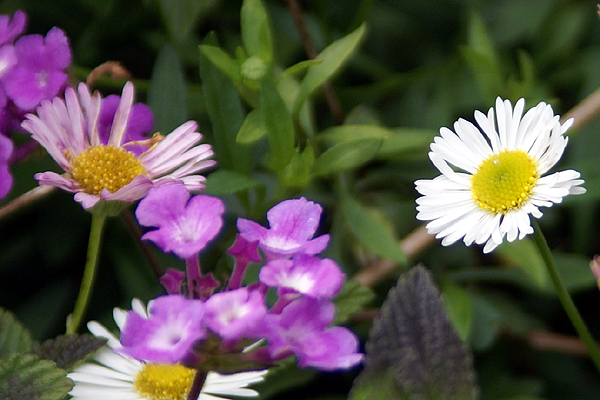
There were lots of dime sized daisy type flowers, scattered in the raised stone beds along with some lantana which is very drought tolerant. They tend to have very small purple or orange flowers on them. In the picture, you can see some of the purple lantana near the white daisy. We found the cache, well hidden in one of the raised beds, very well cammoed. I seriously doubt this particular cache will be muggled. It was well done and it gave cachers a reason for being there looking for the cache and allowing cachers ample opportunity to look natural in the park, without having to resort to crawling in bushes to try and find a smallish container. That's always a plus when you're a middle aged man like myself and caching alone. Having the Tadpole along is much easier in the long run, but I appreciate caches like this anyway.
Just to the north of the park, was an old bridge that crossed Santiago Creek. We decided to walk over to the bridge in the hopes of perhaps finding a benchmark, but once we got over there, I realized there wouldn't be any, at least of an older variety. I can remember that Santiago Creek was a major barrier in many areas of Santa Ana with only major thoroughfares crossing the small stream crossing. During rainy times however, the dry stream bed usually became a torrent. There had been an older bridge 
We could see the old piers for the bridge on the north side of the new bridge, which had been fashioned to look like a 1940s style bridge. It was very well done and tricked me into believing that it was much older than it really was. Once we got up close, I could tell the bridge was less than 10 years old. The concrete was very smooth and new looking. We didn't find any benchmarks (I checked later on the site and no benchmarks were within a couple of miles of the bridge), but we enjoyed exploring it and the Tadpole seemed to enjoy the local history lesson I was able to give about the area when I was growing up. It was another enjoyable father/son kind of day.
Pictures were taken at or near the following geocache:
Sarah May Downie - by Rick&Liz

Wednesday, March 4, 2009
One last smile
I created this map using the Tiger Mapping Services offered by the United States Census Bureau. It's a free service that allows 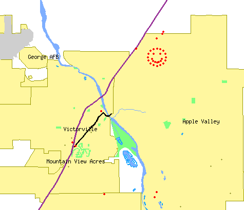
There are all sorts of parameters that you can set with these maps. I like to see the county lines on the maps since I'm interested in finding a cache in every county of California and that allows me to see at a glance what counties I still need. I like the map because I can actually pick out various caching runs I've gone on with friends. The scale doesn't show the smiley cache run as more than a blob, so I zoomed in on it for this particular map.
If you look closely, you can see other red dots on the map. The two red dots in between Mountain View Acres and Victorville are two caches with ties to Route 66. The northern dot was found by the three of us last Saturday as we made our way over to the smiley caches. The southern dot is a virtual located at a very cool Route 66 museum that I wrote about previously.
As I'm writing this, I think perhaps I need to write a tutorial on how to make these maps. If you don't have too many cache finds, it's a relatively easy proposition to make one for yourself. I have the cache hides and finds map linked on my geocaching profile.

Monday, March 2, 2009
Smile and the World Smiles with You
In a quick post last Saturday, I wrote about a gigantic smiley in the desert and that we were going to attempt to find all of caches in the series. 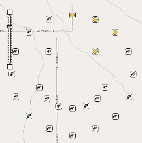
We left our house near 8 o'clock in the morning for the drive up to Victorville in the high desert. We had a couple of side trips to grab a couple of virtual flags that were out there and once we nearly got those taken care of it was time for lunch. After lunch and a couple more caches and one more flag, we decided to head on over and tackle the smiley series.
At first we weren't sure how we were going to progress on this trip. We found a nice dirt road in that went up and over a small hill. At the top of the hill was a nice pullout for cars, so we stopped there. Well, the other reason that we stopped was a cache not 56 feet north of where I'd parked the car. It was the first of the caches in the series.
The caches were all hidden in similar fashion using material that had been found out in the desert, so the hides were fairly easy. We just had to make a decision after the first one and that was how to proceed. Not having four wheel drive made the decision a little easier. We decided to hike the series. It had been advertised at a 1 mile in diameter circle, meaning the circumference of the circle would be 3.14 miles. Well, it wasn't quite like that, because there was another semi-circle making up the smile and also the two eyes.
At the first cache, we also noted that someone else had been out doing the series either at the same time or earlier in the day. We saw Clayton and Karen in every log book, but we never did catch up with them Saturday. After our second find around the outer circle, we cut in to the right eyeball, since we were at the closest point to it. 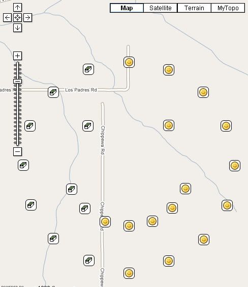
I've been able to cache a couple of other series like there, where all the caches had a them to them. One series really sticks out in my mind because every cache container was exactly the same and it was hidden the exact same way. The only difference was a slight deviation in the name. We had to take meticulous notes on that series so we didn't make a mistake later on when logging the caches. This one had similar elements, but there was enough variation, especially the names of the caches, that it didn't become a problem.
The first section of the series was rather uneventful. When we got down to the south east part of the face, we started doing zig zags back and forth between the chin and the smile so we could get as many of the caches in the least amount of distance. At one of these zig zags, I spotted a small burrowing owl flying just over the tops of the mesquite. It landed near a mound that I assume was its burrow, but didn't want any part of us even though we were quite a ways away. As soon as it thought that we were moving closer to it, it took off again.
Midway through the smile, things began to get interesting. We found a cache, and discovered another set of names after Clayton and Karen's, that of Gumby and Pokey. This was a little perplexing since we hadn't seen their names in previous logbooks, yet here they were now showing up about halfway through the series. As we continued the hike, we realized they must have started the opposite way and traversed the smile in a counter clockwise direction while we were doing the same thing in a clockwise direction. We had to have missed each other while we were zigging and zagging between the smile and the chin.
Interestingly, Gumby and Pokey are old time cachers like me. They joined Geocaching in February 2001 about a month before I found out about it. I've found several of their caches in my neck of the woods and they've 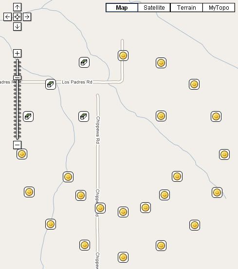
There was also a mystery/puzzle cache attached to this series of caches. Clues to the whereabouts of this cache were to be found in the other caches around the smiley. Halfway through and we'd pretty much figured out where the mystery, or final as we came to call it, was going to be. We still needed some more information and we eventually found it in the other caches.
Looking at the maps, this must have taken some time to put together. It's not a wonder that it was a team of cachers, Dog Will Hunt, bigdaddygrc, Mr. G., and Rhino Assault Team that put it together. It's pretty simple math to decide where to place all of them (each cache was 22½ degrees around the circle), but finding the right spot and doing all the logistics would have taken a long time for just one cacher. Three cachers probably spread out the work load.
The sun was setting and we were nearing the end of the journey. We'd found the last piece to the final cache, so we decided to to get that before getting the last of the outer rim. This saved us about a quarter mile in walking, not much when you really think about it, but we were tired and that last mile just seems to take a toll on you. The final was an ammo can with lots of goodies in it. I decided to take a diabetes travel bug. Chaosmanor placed a couple of travel bugs and a geocoin to cover what I'd taken. Now it was off to the last cache on the outer rim and then a short 2 tenths of a mile hike back to the car and home. The final can be seen on the last map as the smile next to the Interstate 15 freeway. It's obviously not there and you can probably figure out where it really is hidden.
We had to hike up over a small rise to get to the last cache and from up there we could see out car in the dwindling daylight. I could see two people near the cache just next to the car and I put two and two together and figured that it had to be Gumby and Pokey. No one in our party can whistle loudly, so I shouted, but the desert air apparently stifled my cry. However, I could see that as we were approaching the final cache, they too were heading in the same direction.
We got over to that cache and waited for them. As they approached, I heard Pokey shout out, "Webfoot?" So immediately, I shouted out, "Gumby and Pokey!!" I've always found meetings between geocachers on the trail to be enjoyable and this one was no exception to that. It was fun to put faces to names that I'd seen ever since I started caching. Eight 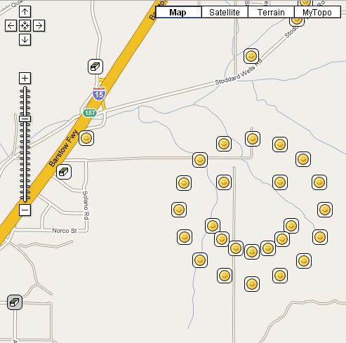
After signing the log for that last cache, we said out goodbyes. They still had to find the final and it was getting dark and we needed to be on our way as well. I put the final on my 5% list mainly because it represents the entire series of caches and was the best of the bunch. My one regret was not taking my camera. I'd opted to go light on this trip mainly because I knew it was going to be a long hike and it would have been tiring to carry it around all afternoon. Still, a picture of Gumby and Pokey would have been nice. I'm still trying to figure out why that blue bra was wrapped around a Joshua Tree out there near one of the caches. Bet that made you smile.

Sunday, February 22, 2009
Maintaining Caches
Yesterday turned out cool and cloudy. After last weekend, which saw rain and/or cold temperatures all weekend long, it was a welcome respite. 
One of the reasons for going yesterday was to grab a virtual flag just north of the Rose Bowl. The flag actually had been placed by the computer in between two fairways of the Brookside Golf Course close enough to the clubhouse that it looked like we could score from the driving range of the golf course. However, I noticed in the paper that the Tour of California bike race was to end in Pasadena yesterday with several trips around the Rose Bowl. That would surely cause logistical nightmares and parking problems for us, so we decided to pass and do a couple of other things that needed to be done geocaching-wise.
Tadpole's first cache, Vic-Tree, had apparently gone missing. With the weather and his Dad's schedule, it made it a little difficult for him to get up there and check it out, so I suggested that we do a maintenance run on his cache and one of mine that had two DNFs (Did Not Find) reported in the past month. Both caches were located along our favorite trail in the Claremont Wilderness Park, so it wasn't much of a push to get either of us out the door and on our way to a strenuous 3+ mile hike round trip.
We came with two decon containers in case either cache was indeed missing. Both had been pretty much filled with stuff from our collection of swag. Yesterday was the first nice day of weather on a weekend we've had in awhile, so the parking lots were both jammed
Vic-tree lies off the main trail in a canyon wash area. The wash makes a nice right hand bend from the trail affording cachers some privacy without having to worry about muggles while looking for the cache. Tadpole had picked the site out on one of our other hikes and was very proud of his placement. This is why I wasn't too concerned about it being missing since it was well hidden in the stump of a tree up above the wash area around shoulder high to me. You'd really have to be looking for it in order to find it. Yet, when we got there, it was gone. We searched all around the tree to no avail.
At that point in time, Tadpole also decided not to re-hide another cache there, but instead opted for a different hide. I suspect that p
We hiked back out to the main trail and continued further up the trail, checking on my Scenic Value cache and then finally to, Today, I saw a Lizard cache. Both of these caches are decon containers that I have added camoed duct tape to and they, for whatever reason, are extremely difficult to find. I had to search for a minute or so for Scenic Value and I knew where it was. I wasn't too worried about it since someone had logged a find on the cache on Friday, but the same person had logged a DNF on the Lizard cache as well, so I knew there could be a possible problem with that cache.
As we walked, we also scouted out locations for another hide for Tadpole, but none of the spots that we looked at really suited him, so we kept going up to Today, I Saw a Lizard. As luck would have it, there were two muggles back near Lizard, so we kept walking back to another cache that the Tadpole ended up finding. I'd already found this one awhile ago while out hiking with friends of mine. We then walked back down the trail and got to ground zero for Today, I Saw a Lizard.
As noted above, this one is another decon that is hard to spot. Once again, my eyes failed me and I couldn't spot my own hidden cache. All at once, the Tadpole 
The mile and three quarter walk back to the car took most of the rest of the morning, so we decided that our stomachs were more important than trying to find hiding spots for the two caches that we'd brought along on this hike. I started thinking about my own record of cache maintenance and decided that I need to make sure and check my caches from time to time, especially if there have been DNFs logged recently. I know that I don't like it when I get out to a cache site, try to find the cache and then notice on the cache page a string of DNFs logged. The maintenance run on Today, I Saw a Lizard started that process. After all, maintaining caches is part of the game.
As a side note, all of the pictures were not taken yesterday, although in hindsight, I really should have taken some pictures because the views from up there were gorgeous. In the last picture, the mountain in the background is covered with large amount of snow at this time.
Pictures were taken at the following caches:
Vic-tree - by Tadpole95
Today, I Saw a Lizard - by Webfoot
Scenic Value - by Webfoot

Thursday, February 12, 2009
The Interstate 5 run
I'm starting a long four day weekend today. As of 2:10, the weekend had begun, but I stayed at school about an hour longer to get some paperwork done before heading out. 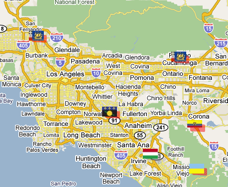
If you look at the map, you can see a nice line of 4 virtual flags running in a southeasterly direction, or northwesterly direction along Interstate 5. The purpose of this game is to get to within 100 meters (325 feet) of these virtual flags and tell others what you found there. Points are scored for each flag found. I found the Ecuador flag just south of Corona on the map last week and the flag situated in what looks like the middle of Rancho Cucamonga is pretty much inaccessible to get. The red highlight around the flag indicates that it's about to expire within the week and then won't be there anymore. Not like it's there anyway, since it's just a virtual flag. I could still go to the point, but couldn't score any points for the flag after it expires.
We plan on starting at the northwest end and work our way to the southeast on this particular trip. I ran some PQs around each spot where there would be a flag present, so at each spot we'll grab a couple of caches as well. I looked over some of the caches last night and picked a couple out that I want to try and get. That's one of the reasons I got interested in GeoVexilla. The flags are randomly generated, so when flags come up near where I live, I can go out and get those flags, plus possibly cache in a new area where I haven't cached before.
There appears to be an interesting virtual cache at an automobile museum near Sylmar. I wasn't aware there was a museum up in that particular area, so I'm hoping it should be an interesting side trip for us. There are also a couple of Letterbox Hybrid caches down in Orange County that we might be able to get as well. I've been working on a Letterbox Hybrid of my own, but haven't found the right hiding spot for it as yet, so getting one of these might prove helpful. Letterbox hybrids involve using clues, not necessarily geographic coordinates to find the cache.
All of the caching will be weather dependent since we have a high chance of rain tomorrow. It's actually supposed to rain the entire weekend (who ordered this up on a four day weekend no less?), but we'll see what happens. Tomorrow looks the least likely for us to get wet, so that's a good thing. We do have one more stop that's not marked by a flag on the map and that would be lunch. Since we're going to be driving very close to corporate headquarters of In-n-Out Burger, we're planning on stopping there for lunch. There's a micro there which we hope to grab and a couple of blocks north is a cache hidden near one of the old stations to the Pacific Electric Railway, commonly called the Red Car. For those of you not from Southern California, and have never heard of the Red Car, the movie "Who Framed Roger Rabbit" deals with the eventual demise of the Red Car in a very humorous way. Whether that's actually what happened or not is beside the point. It's a very enjoyable and well done movie and had some good groundbreaking new types of animation in it, pre-Pixar.
I don't see too many obstacles to our run tomorrow. It should be an enjoyable day. I'll write more about it later in the weekend, particularly if I happened to be rained in for the rest of the weekend. I'll not complain though, since the entire state needs a few more good soakings this year and perhaps every year to keep the reservoirs filled. Drought is not a pretty thing in the state of California.

Sunday, December 14, 2008
All gave some, some gave all
Saturday, the Tadpole and I went out to get some virtual flags (GeoVexilla) and to find several virtual caches. He's been sick for most of the past week, but wanted to get out, 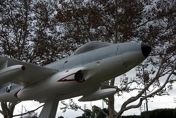
One flag took us to a residential neighborhood just around the corner from the Great Western Forum, former home to the Los Angeles Lakers and Kings. Another took us to the track of a junior high school in Santa Ana, California where I grew up and the third would have taken us right in the middle of a busy street in Stanton. That's the nature of these virtual flags. You never know exactly what you might find there since they get generated randomly by the computer program. Sometimes I've had to hike for them, other times, they're just by the side of a road.
Interspersed with these flags were four virtual caches that I hadn't found yet in the Los Angeles area. The very first one looked to be quite fun at first. As we were approaching the park where the cache was, I noted a large airplain up on a pedestal. Since the cache was called Airplane Park Cache, it made sense, so I noted to the Tadpole that it looked like we were going to have to get some information off the monument in order to get credit for the find. At that time, I hadn't read the cache page, so I was a little unprepared for what we would be looking. 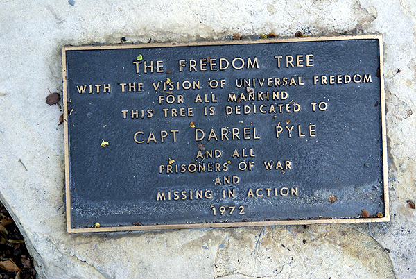
The plane was a monument to fallen soldiers of the Vietnam War who also hailed from the city of Lakewood, California. There were 42 names on a plaque attached to the pedestal of the plane and we had to find four names, all high school buddies of the cache owner and all who didn't come back from the conflict. Having never lost a buddy in war, or any other way, I cannot imagine the sorrow at losing a friend like that, let alone four. Needless to say, it put a somber tone to most of the rest of the day. Even the Tadpole was affected by my mood.
I feel these monuments are important for our society to remember those who fight to preserve out country's way of life. Vietnam was a very unpopular war. Wouldn't it be nice if we could say that all wars were unpopular? But, just because the war was unpopular, doesn't mean that we should not show the respect to our soldiers who fight in these wars. These war memorials dot the landscape all over the country. Some are well known, while others are only known by a handful of people who live near them. Geocaching allowed me to find another monument this weekend, to learn about some others who fought, those, who before yesterday, were known by two less peop0le than they are today.
As I write this, I'm also thining about my niece's husband who is somewhere in Afghanistan with his marine unit. He's scheduled to come home sometime in January. Somewhere....sometime....that's the nature of this business. We really don't know where he is and we really don't know when he's really coming home. We all pray that he comes home in one piece both physically and mentally.
Looking back at this piece, it didn't turn out to be anything like what I intended it to be. Apparently that first virtual struck a nerve with me.
Pictures were taken at or near the following geocache:
The Airplane Park Cache - by ScurvyDog

Sunday, July 6, 2008
Journeys
Saturday, our family went to visit my in-laws in  I’d planned on capturing a virtual flag which was very close to their house. We left fairly early in the morning, earlier than most times and I attribute that to the fact that my daughter wasn’t with us. She’s the one who ends up sleeping in and not getting up early as the rest of us. My 16 year old son has learned the benefits of sleeping in, but he was up by 9 AM and we were on the road by 9:30. Let’s face it, guys can get ready more quickly than girls.
Once up there, we sat around acclimatizing ourselves to the mountain altitude and then started fixing lunch. Lunch is always an experience at my in-laws house. I think one of the reasons my mother in law fell in love with me was because I ate her food, and lots of it. Needless to say, she pulls out the stops whenever we eat, even if it’s just sandwiches, which is what we had for lunch. Blondie’s Dagwood would be hard pressed to beat me in a sandwich making contest.
After lunch we went for a drive, basically to find a place to do a small hike. At first we decided to go up to 
The lookout station is manned by volunteers and you can climb to the top of the tower when it is occupied to check out the view. On clear days, you can see out to
We pointed out some of the sights to my older son who climbed the tower with us. I tried to point out the mountain peak that I used to identify with when I was a youngster, having grown up on the opposite side of that mountain down in  deal well with heights also stayed down below.
After coming back down, we drove over to capture the flag, worth 4 points for me in the game, and to do our hike. Getting over to the flag was easy, but capturing it wasn’t since the game dictates that you have to be a minimum of a 100 meters to capture it and we were stymied by a road closure that kept us a quarter mile from the flag. I knew there were other access points, but they would require bushwacking, which would be out of the question for my nearly 80 year old father in law and my 76 year old mother in law, so we found another trailhead on which to hike, with a nice level terrain along the waterfront.
Everyone had a good time. We got some pictures on our hike and we tired the dog out. He slept most of today and at this moment is sleeping near the feet of my wife in the other room. What I was most impressed with were my two sons. When their grandmother got tired near the end of the hike, one of them and then the other in turn assisted her back to the car, helping her along, just by being there for her to lean on for support. I know I probably didn’t have that kind of compassion at ages 12 and/or 16.  I was pretty self indulgent as a kid and didn’t grow up for a long time. I was glad to see them taking care of other family members in need.
Each day I thank God that my kids have all four of their grandparents. By the time I was 13, I had none. I’m thankful we live close to them so we can visit. I grew up in

Saturday, April 12, 2008
A day with my son
One of my friends said to me via email this week, “They say that there is nothing so dangerous as a new convert” in regard to my sudden interest in capturing virtual flags. This might be true, as I tend to get kind of obsessive about things that I really like. But then again, I think many people do the same thing. I took the Tadpole out today to capture some flags and find some caches, trying to get him out of the house on a gorgeous day. Our high today here hit 93°. At least that’s what it said on my backyard thermometer this afternoon. I’m sure it was hotter in other places. After reading about weather in other parts of the country, I'll take it.


Saturday, April 5, 2008
Capture the Flag
The past two days have been a welcome change of scenery for me. Friday, I was able to get out again and hike up in the foothills. Not much mileage, less than a mile total, but I took along my new cache and hid it up there. I came back home, submitted the cache page and it was approved by the powers that be in less than fifteen minutes. That has to be a record for me. The Window of the Soul is now live. No one’s made a find yet on it, but that will come eventually.
 ourth 8 and the fifth is worth 16 points. Each completed set can get you 31 points.
 ond flag, representing the

