Last week, on my hike in the North Etiwanda Preserve (NEP), I tried calibrating my GPSr. 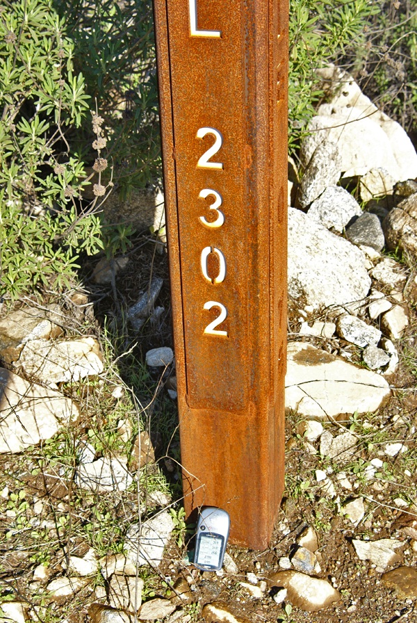
When Chaosmanor and I hiked to the top of Simi Peak back in November, I put my GPSr on top of the bucket on the peak that held a laminated piece of paper stating the height of the peak, 2403 feet in elevation. I just wanted to see if my GPSr would register the same. It did, after a fashion. We actually watched the number start out at a lower elevation and then watched as the number climbed up to 2403 feet, which was when I snapped the picture. I suppose that if we were willing to wait several minutes of battery life, the unit would have settled down and produced a constant elevation. I might have to try that sometime, but it's not high on my list of priorities.
The NEP has mile markers every quarter of a mile. Those mile markers also indicate the elevation at the point as well. The last time I'd been hiking in the preserve, over a year ago, I did the same thing and got the exact result. This time, the result was four feet different than what the sign post said. After taking the picture, I picked my GPSr up and it immediately registered the "correct" elevation. Then again, does the elevation listed on the marker indicate the elevation at the top of the pole, or at ground level? My assumption would be that it should be a ground level.
Picking up my GPSr, actually brought it up to the top of the pole, which would have been the four feet difference, but once again, it's readily apparent that these gizmos shouldn't really be used for super accurate measurement of elevation or of latitude and longitude. And yes, I'm writing this all with tongue firmly planted in cheek this morning. After all, it's just a game we're playing out here.
Picture was taken near the following geocache:
NEP on the Rocks - by maddmaxxawr
Sunday, January 9, 2011
Calibration

Saturday, September 11, 2010
September Slowdown
Once again, September has become a slow month for me caching. However, in about a half an hour or so, I plan on hitting the road with my good friend Chaosmanor for some caching and GeoVexilla and also some GeoDashing. It's been a tough couple of weeks, so my apologies for not writing in here.

Sunday, May 2, 2010
Thanks Dave
In the spring of 2000, President Clinton signed an executive order allowing for the removal of selective availability of GPS satellites. The implications of this meant that hand held GPS receivers would be more accurate and navigation systems would start to become standard features in many cars. 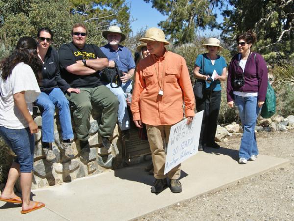
On May 3, 2000 Dave Ulmer hid a black painted container in the state of Oregon and challenged an on-line community at sci.geo.satellite-nav to go and find it. The first geocache was born, although at the time it was called the First GPS Stash. Within days, that first stash had been found. Contained within that five gallon bucket were a Delorme Topo USA and 2 CD Roms, a cassette recorder, a "George of the Jungle" VHS tape, a Ross Perot book, 4 $1 bills, a slingshot handle, and a can of beans. The original cache is no longer there, but the spot can still be visited where there is a plaque placed commemorating the original stash. The can of beans, heavily rusted but preserved, is now a travel bug.
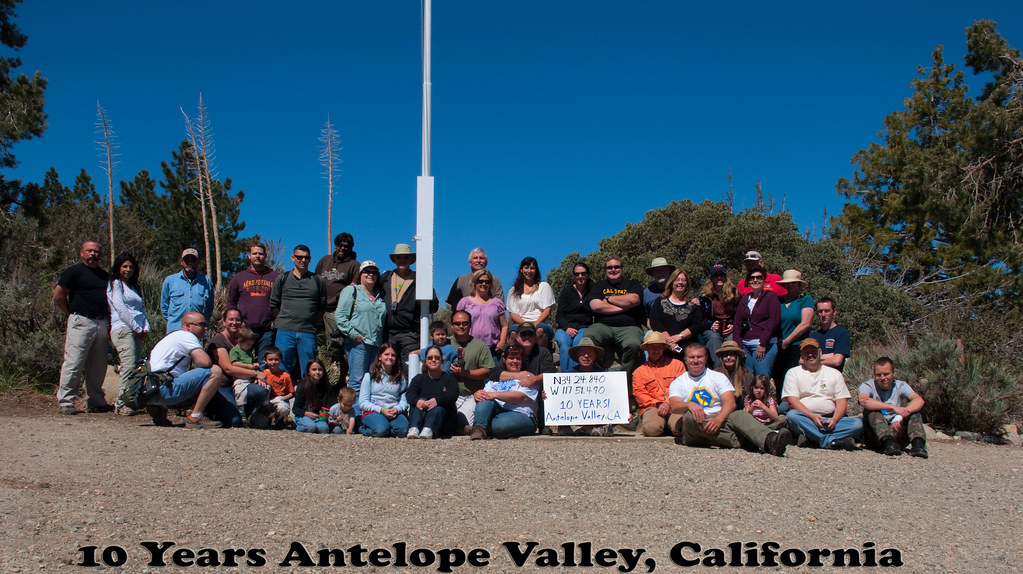
This weekend, I traveled to the Devils Punchbowl to celebrate ten years of geocaching. Events were held all over the world, but I found myself in a void, with the nearest event more than 30 miles away driving distance. I decided to attend the event in the Antelope Valley mainly because it's a very scenic spot, plus there were going to be opportunities for some hiking after the event. After all, when I started geocaching back in 2001, that's what it was all about. The requirements for a 10 year event, as posted by Geocaching.com were that the event needed to have a picture posted showing at least 10 people at the event plus a sign indicating the coordinates of the event in the picture. Our event picture is here.
This was my 9th event in just over 9 years since starting this silly game. I don't know why I don't attend many events. I could probably go to at least one event a month if I so choose, I just don't and there's not really a reason why I don't. This event, hosted by Kit Fox, was a lot of fun. I met one of the hiders of the Groundspeak Series and Smiley Series, Bigdaddygrc. I had a very pleasant conversation with him about geocaching and other things. I also spent a good deal of time with a fairly new cacher, HD-MsTree. I got to meet mcattk again, after bumping into him out at the Groundspeak Series a couple of months ago. Time was also spent with Yosemite John and Debbie and Tevis Clan. Several of us got a great review of Tevis Clan's new Lowrance GPSr. 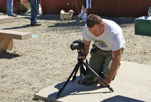
While on the hike we ended up bumping into several other cachers that had been at the event. W_bovine was walking down the trail from a multi-cache as we were heading up to it. That's w_bovine holding the sign in the picture. We had a pleasant conversation and I encouraged him to head over to my neck of the woods if he wanted to do some more hiking and caching. There aren't many hikers in my area, so my caches don't get found very often, so any new finders is a bonus in my mind. He said he would check it out. While on the hike, Chaosmanor and I discussed the different rock strata of the rocks in the Punchbowl, while figuring out the requirements of an earthcache along the trail. We also watched rock climbers playing their game. I'd tried that once when I was in college and made the mistake of looking down about halfway up a pitch. Never again. But then again, I would suspect that those rock climbers might think the game we were playing a little too mundane for them. To each his own.
At the end of the day, I counted my finds. Including the event, I found 8 - an event, a multi-cache, a mystery cache, two earthcaches and three traditional caches. It was a very modest day numbers-wise, but a very good geocaching day. It's not about the numbers of caches you find, but about the experiences you have as you play the game. I think I played the game well yesterday. Thanks Dave.
Pictures were taken at or near the following geocaches:
10 Years! Antelope Valley, California - by Kit Fox
Devil's Punchbowl - by Yosemite John and Debbie

Sunday, March 21, 2010
Done
Yesterday, my friend Chaosmanor and I trekked back out into the desert to complete the Groundspeak Series of caches. Last Saturday, we'd completed the lower half of the G+, getting 19 of the 40 caches in the series. We hiked the lower portion, putting in about 6 miles of hiking to get the 19 caches.
Fast forwarding to this week and we heading up to finish it off, getting the other 21 caches plus the mystery cache and perhaps the bonus cache. 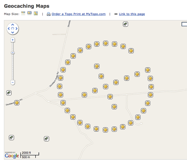
We still ended up hiking about 4 miles on Saturday, giving us over 10+ miles of hiking on the route to get all of the caches. We'd looked at the terrain maps and without a high clearance vehicle, the bonus cache was going to be too tough of a hike, especially late in the day, so we opted not to do that one. The last 7 caches were part of a 2+ mile round trip hike over extremely rough terrain. We were up to the challenge and it was in the very last cache that we found the last set of coordinates for the mystery cache.
We'd also run into other cachers out on the G, all of which were from my local area. Funny how you have to drive 45 miles to meet up with people who live in your own neighborhood, but that's the way it worked. We ended up running into them on four different occasions including at the final mystery cache. After the log had been passed around, we told some geocaching tales, enjoyed each other's company and then parted ways to head back to our respective homes. This was a series well worth the adventure.

Saturday, February 20, 2010
Honored
Today I found a cache. Just one, but it was a nice one. I was aware this one was going to come on line sometime today as the cache owner had forewarned me about the possibility of a new cache in my area. When I left the house this morning at 10:30 to find some virtual flags in GeoVexilla, it hadn't come on-line yet, so I really didn't think much of it.
When I got home to log the flags that I'd found, I noticed an email from the cache owner encouraging me to get out there and find it and since the cache was only 1.62 "Crow Miles" away from home, I headed out again, much to the consternation of my wife. 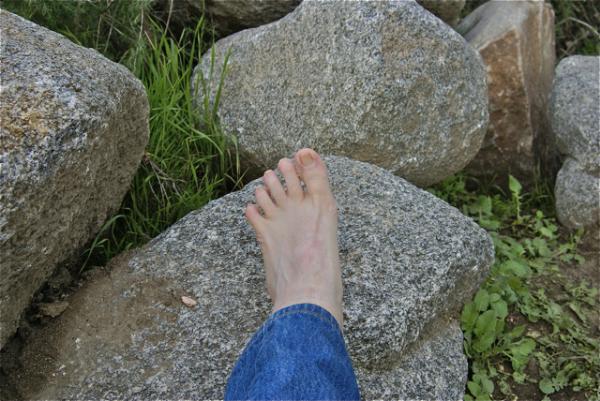
When I got to ground zero, there were already two people standing there. Looking at them, I didn't recognize them, but we made introductions and they were two other local cachers, whom I hadn't met, so that was a bonus right there. We spent a good ten to fifteen minutes looking for the cache and as I noted in my log, had the cache been alive, it would have bitten me on one of my webbed feet. I soon spotted the cache, then backed off for the other cacher to have the opportunity of finding the cache as well.
We exchanged some more pleasantries and then made our separate ways home. I decided to take a picture, just to dispel any rumors that surface from time to time as to where I actually got my cache name.
I am still at a loss for words that maddmaxxawr wanted to place a cache in my honor. I hope that I can live up to the standards that I have apparently been setting these many years that I have been caching. I know he's a follower of this blog, so I'll publicly thank him here for the great honor.
Picture was taken at the following geocache:
Webfoot has Webbfeet in Webb Canyon - by maddmaxxawr

Monday, November 2, 2009
Capture the Flag again
This weekend was a very enjoyable weekend. My first trimester of school ended and because I had all my grades already done, all I had to do was bubble in the grades on our computerized form and turn them in this morning. 
Saturday morning, early was devoted to rounding up all of the electronic equipment that either didn't work any more, or had outlived their usefulness in our household. My wife's school was having a free e-Waste disposal that day, so it made for an easy and cheap way to get rid of a couple of excess monitors and other electronic stuff that had been sitting around the house for awhile. After that, I decided to go out and find some virtual flags.
Some of you know that GeoVexilla is a virtual flag game that places random international flags virtually around the globe. Each time you get within a 100 meters of a flag you score points for that flag. When you find a flag, you generate a new set of five flags. The first flag is worth 1 point, the second 2, the third 4, the fourth flag is worth 8 and the fifth and final flag is worth 16 points. 
Two of the more interesting spots I found flags was on the top of a mini-mall in Long Beach. The flag of Belize was perched on top of the roof of a Bristol Farms store. I couldn't quite zero out on that flag, but was able to easily get within 100 meters, so I scored the one point. That was the first time I've found a Belize flag, so it generated a set of flags for me. Because of other flags that I've found in the past, I was able to move flags around and actually fill out the entire set that this particular flag generated, which gave me 31 points for a full set. Of course, since I moved flags around, that created gaps in other sets, but I'll eventually fill those in as time goes on.
Another flag that I found this weekend was a Columbian flag which was flying high on a ridge overlooking an avocado farm near Temecula, CA. I was able to take roads through an organic avocado farm, then walk up a short paved trail/road to get within scoring distance for this flag. 
That's one of the nice things that I enjoy about this GPS game. Because the flags are randomly generated, there's some unknown quality built in to finding the flags. It's not like geocaching where you know someone has been there. With this game, it may not be possible to access a point, because of private property laws, or other restrictions. Sometimes they end up being placed by the game's computer in the middle of a wilderness area with no accessibility. Just in the last day, a new Bahamian flag has shown up in the Long Beach harbor. It looks like the only way to score this one would be to take a boat into the harbor and sail over to the point. It's the randomness that makes this game fun.
Pictures were taken at or near the following virtual flags:
VX39-UDOD
VX39-UVAS

Wednesday, July 8, 2009
Beach caching
Today, the Tadpole and I traveled down to San Diego. There was a Vexilla flag down there worth 8 points to me, plus a dashpoint, so we put the two together along 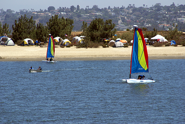
The flag find was an easy find as were the caches today, but the island was a neat little adventure. Each cache was hidden in a similar fashion usually under a bush, however there were a couple of variations. We even had one cache that was guarded by an attack lizard. Not really, but I spotted this lizard on a branch and as I was watching the lizard, I also spotted the cache about a half an inch away from the lizard. Unfortunately, I got to close to the lizard with my camera before taking the picture 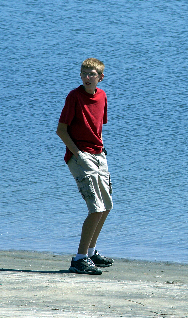
Fiesta Island and nearby Dog Island are all connected, so I'm at a loss as to why one island is named differently depending upon which side of the island you're on, but I have a speculation. At one point while walking over to find our second cache of the day, I looked at the screen and the mapping software in my Garmin had us in the water. Not just near a shoreline, but totally in the water for at least 800 feet in all directions. Now, when I looked around, all I saw was land, but my GPSr was saying there should be water there, which leads me to believe that the part we were walking on was water at one time in the not so distant past and it has been filled in, thus rendering two islands into one.
When I started looking at this island yesterday in preparation for the today, I noticed a series of caches that had been temporarily disabled. Apparently, there is a big softball tournament on this island in July and the attendees get kind of rowdy. The cache owner of this set of caches temporarily disables his caches, and does maintenance on them during the month of July, then puts them back out again in August. Which means that we could come down here again in the fall perhaps and there will be a bunch more caches for us to find. That's always a plus, especially when you don't end up finding a couple in a given area.
The day was pretty much picture perfect. The Tadpole got to enjoy a secluded beach and toss a couple of stone in the water. The sail boats were out in force. We
Pictures were taken at or near the following geocaches:
KITEBOARDING - by Splashman & Splashette
DRAGON'S FIESTA! - by DRAGONJD
GB #3 tanner_scout - by lulu499 and LegoCollin

Wednesday, June 10, 2009
A walk in the park
The day before appendicitis took down the Tadpole, we drove down into Orange County for GeoVexilla and some caching. 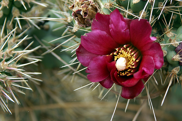
The first flag was found easily, in between two houses, then we drove over to Aliso Creek County Park to hike down to a virtual cache. From the parking lot, the cache was only 1.37 miles away, so it looked like it was going to be an easy walk since the trail was a paved trail designed for biking, so we didn't think it would be too strenuous. There were many wildflowers in bloom, including staghorn cholla cactus. For perspective, the blooms in the picture are about the size of a quarter.
Every now and then, I fail to look at maps that closely. I assume that most caches are placed close to roads and/or trails, so 
On top of that, if we chose to bushwhack, the hillside was filled with foxtails. Anyone who is a regular here, knows that foxtails are the bane of my existence. I will venture into fields of foxtails only as a last resort. Upon further inspection, it wouldn't have worked anyway, since there were fences that we would have had to cross in order to get to where we were going. In other words, we needed to stay on the trail.
Our time was limited, because we had planned other virtual flag grabs, but I figured if we were having a good time, we could continue on. Whenever I go with the Tadpole, I like to leave it up to him, giving him some ownership into the decision making process we do with this hobby of ours. It's probably something that I learned when caching with his older brother. I wasn't quite as willing to let him make those decisions and it's probably one of the reasons why he's not enamored with the hobby in general.
With that in mind, I laid out our options to him, telling him that we'd have to go around the ridge to get to the cache. He opted to cut the hike short and 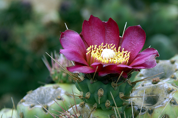
Pictures were taken at or near the following geocaches:
You are cleared to land - by Quietman33
Dripping Cache - by dr.bob

Sunday, May 31, 2009
Desert disks
Saturday, I went up to the mountains to pick up my daughter. Obviously, since this is more about the desert than the mountains, I took a pretty circuitous route to get to the mountains. In fact, it was a rather longish route, but very fun.
I've been watching a couple of the virtual flags out in the desert and noting that several of them were about to expire, so I decided that Saturday morning would make a good trip out to get them. I created a bookmark list of caches along my intended route as well, so 
My route took my up the Interstate 15 into Victorville, then east toward Apple Valley. There I was able to score a Bhutan flag. I also found a small cache behind a movie theater. Then I proceeded east along a road the Tadpole and I had traveled in the past. My goal was to head to the northern border of Joshua Tree National Park, mainly because there was a cluster of 3 virtual flags out there, plus one nearby.
As I was traveling, I kept noticing some of the caches that had been part of my PQ show up on the screen. There didn't seem to be adequate stopping areas for many of the caches, or either I was driving too quickly to make good stops, but I was able to make one stop at a cache entitled, POINT. Team Christiansen has created a bookmark of caches in the Apple Valley that are placed near benchmarks. With 32 caches on the list, someone who is interested in benchmarks would be able to spend a rather enjoyable day out there finding caches and logging benchmarks.
After parking near POINT, I got out of my car and immediately spied the nearby benchmark. No, not just one did I spy, but three benchmarks. This was almost as good as the other cache where the Tadpole and I found five benchmarks in one spot. After finding the cache, I went over to document the benchmarks. There were three benchmarks aligned in a row just off the highway. After taking the requisite pictures of each, plus a picture of each so people could get perspective on how they looked in the environment, I checked the cache page and realized that I'd missed one. A quick survey and I was able to spot the 
I was able to log three of the four marks. One of the marks in the line of three was a newer benchmark from 1983 and wasn't in the benchmark system at geocaching.com. The other three, arrayed in a triangle shape all dated to 1934, the year after my parents were born. I'm at a loss at this time as to why the National Geodetic Survey wouldn't have that last mark in the database yet. Yet, I encountered another benchmark once I got over to the other virtual flags that wasn't in the system either.
This benchmark, which I found 38 feet away from a hidden cache, was a pipe cap type of benchmark, driven into the ground right on the boundary of Joshua Tree National Park. The mark is dated from 1932, so it's relatively old and I was hoping that it might be in the system, yet when I checked later on, it was not to be found. 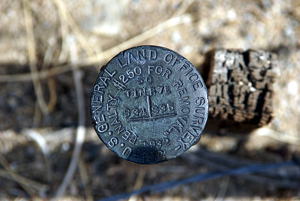
I think I'll keep these photos in a safe place. Who knows? Perhaps in the future, I'll be able to pull them out of the archives and log them when the database gets updated. From past experience, I was pretty sure I'd logged all the ones in my local area, but now it appears as if new ones are showing up in the database. This would indicate that the database does get updated from time to time. Now I just need a way to remember that I have them.
Pictures were taken at or near the following geocaches:
POINT - by Team Christiansen
Architectural Digest - by Joshua Tree Bonnie & Clyde

Sunday, April 26, 2009
Urban Jungle Road Trip
The Tadpole and I went on a road trip Saturday, ostensibly to grab some virtual flags in the Los Angeles Basin. The flags were stretched all the way from Thousand Oaks to the west of us, down to San Clemente south of us. S ix of them lay waiting for us to drive up and claim the flags, and thus, the points for the flags. We were successful in getting all six flags. The red dots on the map are the different locations we went to get the flags. We ended up getting only one geocache, one that happened to be near the flag in Thousand Oaks. We weren't sure if the Tadpole had found a cache in Ventura County yet, so we stopped there to get this cache to be sure. We remembered later that we had cached together in Ventura County, so in reality, the cache was just a bonus, not fulfilling any kind of challenge, but just there for the fun of finding it.
The thing I love about GeoVexilla is each flag can be worth different points to different people playing the game. For example, we "found" flags of Nigeria, Saint Pierre and Miquelon, St Vincent and the Grenadines (shown below), Nicaragua, Poland and the United States. When a flag is found, the website computer generates a five flag set. The first flag in the set is worth 1 point. Any other flag found for that set would be worth 2 points for the second flag, 4 points for the third, 8 points for the fourth and 16 points for the fifth. Each set is worth a possible 31 points. I could be finding a flag with a friend of mine which might open a new set up for him, but could be worth 8 points to me, because it's already in an existent set. When flags appear on the web site, you have to be ready, because they have a  limited lifespan. Most tend to last about two weeks, but I've seen some come and go in just over a week.
It's also possible to move flags around. If you look at my flag sets and scroll down to the bottom, you'll find several sets that are empty. That's because I've moved some flags that could fill in other sets. I enjoy it, because I enjoy going to places where the possibility of getting the flag could be suspect. Not all flags can be grabbed, due to property laws, or terrain, whereas, technically, all geocaches should be able to be grabbed, since another human being has been there already to place the cache.
The GeoVexilla game site is another way to use my GPSr. My son likes finding virtual flags, if nothing more than he gets to see the flags up on my flag sets. I noticed a flag in the hills south of Thousand Oaks. I hadn't ever seen that particular flag design before, so I looked up the island of Niue. I learned it's one of the largest coral islands in the world.
The other thing the site allows me to do is expand my geocaching area. Yesterday wasn't a geocaching type of day for us, with each of us preferring to just grab the virtual flags.  Other times, with fewer flags in an area, we might pinpoint a flag, grab it, then find some caches in the general location. I've discovered a couple of nice trails this way and have plans to go back into Riverside County, south of us this fall when it gets cooler to hike this trail that we found because of the virtual flags.
Now that we have our vacation plans formulated for this summer, he and I can start looking at our route to check on geocaching possibilities. Scouting for flags will have to wait until close to our camping trip since they have a limited lifespan on the site. Overall, finding the virtual flags has been a pleasant addition to our GPS using experience. Much, like geocaching, it gets us out and about, gets us to explore new territory and helps us enjoy the outdoors and each other. Try it, you might like it.

Wednesday, March 18, 2009
Tucked Away Treasures
After dropping off the two travel bugs near Disneyland, the Tadpole and I headed south into Santa Ana. We had two reasons for heading that way, the first being a virtual flag just around the corner from one of the elementary schools I attended. Amazing as it may seem, we didn't move once after my parents purchased the house in south Santa 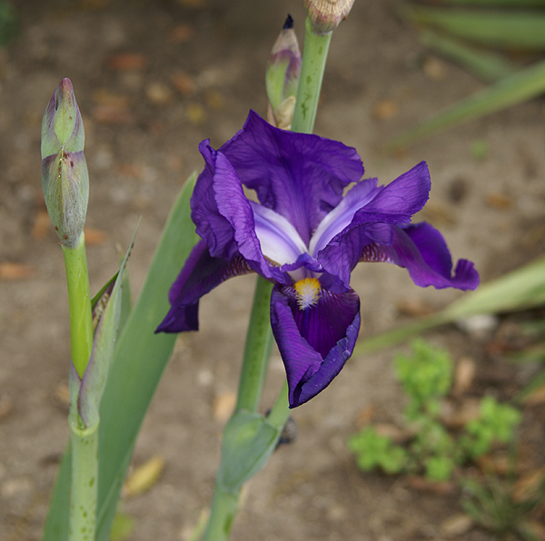
Unfortunately, I might not score any points for this flag. The GeoVexilla site has been down for almost a week. The map shows up on the main page, but no flags do. One of the other game players kept a daily database of all the flags and sent me a spreadsheet of all the flags that were within 100km of my home coordinates, so I was able to score that USA flag and the flag of Cyprus just north of Anaheim and Disneyland. If the site doesn't come back soon, I might not score the points, but that's OK. It was the adventure that counted anyway.
After scoring the USA flag, we headed east, just beyond my 6th grade school. There was a geocache about a half mile away that had looked intriguing when I'd scouted it out last week. Sarah May Downie had been placed in a small little park located at a rather odd intersection. The oddness of the intersection, five streets all coming together, made for some interesting pieces of land. The park was on a small triangular shaped piece of land between two of the streets that converged on this intersection, too small for a house, but the perfect size for a small memorial garden type of park. It was one of those tucked away treasures that all of us have stumbled across from time to time.
The cache page said the cache was hidden in a herb garden. I'm not sure about the herbs, but there was a variety of plant life. There were several bottle brush bushes that had grown fairly tall. I could hear two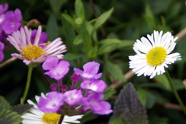
There were lots of dime sized daisy type flowers, scattered in the raised stone beds along with some lantana which is very drought tolerant. They tend to have very small purple or orange flowers on them. In the picture, you can see some of the purple lantana near the white daisy. We found the cache, well hidden in one of the raised beds, very well cammoed. I seriously doubt this particular cache will be muggled. It was well done and it gave cachers a reason for being there looking for the cache and allowing cachers ample opportunity to look natural in the park, without having to resort to crawling in bushes to try and find a smallish container. That's always a plus when you're a middle aged man like myself and caching alone. Having the Tadpole along is much easier in the long run, but I appreciate caches like this anyway.
Just to the north of the park, was an old bridge that crossed Santiago Creek. We decided to walk over to the bridge in the hopes of perhaps finding a benchmark, but once we got over there, I realized there wouldn't be any, at least of an older variety. I can remember that Santiago Creek was a major barrier in many areas of Santa Ana with only major thoroughfares crossing the small stream crossing. During rainy times however, the dry stream bed usually became a torrent. There had been an older bridge 
We could see the old piers for the bridge on the north side of the new bridge, which had been fashioned to look like a 1940s style bridge. It was very well done and tricked me into believing that it was much older than it really was. Once we got up close, I could tell the bridge was less than 10 years old. The concrete was very smooth and new looking. We didn't find any benchmarks (I checked later on the site and no benchmarks were within a couple of miles of the bridge), but we enjoyed exploring it and the Tadpole seemed to enjoy the local history lesson I was able to give about the area when I was growing up. It was another enjoyable father/son kind of day.
Pictures were taken at or near the following geocache:
Sarah May Downie - by Rick&Liz

Thursday, February 12, 2009
The Interstate 5 run
I'm starting a long four day weekend today. As of 2:10, the weekend had begun, but I stayed at school about an hour longer to get some paperwork done before heading out. 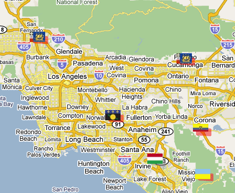
If you look at the map, you can see a nice line of 4 virtual flags running in a southeasterly direction, or northwesterly direction along Interstate 5. The purpose of this game is to get to within 100 meters (325 feet) of these virtual flags and tell others what you found there. Points are scored for each flag found. I found the Ecuador flag just south of Corona on the map last week and the flag situated in what looks like the middle of Rancho Cucamonga is pretty much inaccessible to get. The red highlight around the flag indicates that it's about to expire within the week and then won't be there anymore. Not like it's there anyway, since it's just a virtual flag. I could still go to the point, but couldn't score any points for the flag after it expires.
We plan on starting at the northwest end and work our way to the southeast on this particular trip. I ran some PQs around each spot where there would be a flag present, so at each spot we'll grab a couple of caches as well. I looked over some of the caches last night and picked a couple out that I want to try and get. That's one of the reasons I got interested in GeoVexilla. The flags are randomly generated, so when flags come up near where I live, I can go out and get those flags, plus possibly cache in a new area where I haven't cached before.
There appears to be an interesting virtual cache at an automobile museum near Sylmar. I wasn't aware there was a museum up in that particular area, so I'm hoping it should be an interesting side trip for us. There are also a couple of Letterbox Hybrid caches down in Orange County that we might be able to get as well. I've been working on a Letterbox Hybrid of my own, but haven't found the right hiding spot for it as yet, so getting one of these might prove helpful. Letterbox hybrids involve using clues, not necessarily geographic coordinates to find the cache.
All of the caching will be weather dependent since we have a high chance of rain tomorrow. It's actually supposed to rain the entire weekend (who ordered this up on a four day weekend no less?), but we'll see what happens. Tomorrow looks the least likely for us to get wet, so that's a good thing. We do have one more stop that's not marked by a flag on the map and that would be lunch. Since we're going to be driving very close to corporate headquarters of In-n-Out Burger, we're planning on stopping there for lunch. There's a micro there which we hope to grab and a couple of blocks north is a cache hidden near one of the old stations to the Pacific Electric Railway, commonly called the Red Car. For those of you not from Southern California, and have never heard of the Red Car, the movie "Who Framed Roger Rabbit" deals with the eventual demise of the Red Car in a very humorous way. Whether that's actually what happened or not is beside the point. It's a very enjoyable and well done movie and had some good groundbreaking new types of animation in it, pre-Pixar.
I don't see too many obstacles to our run tomorrow. It should be an enjoyable day. I'll write more about it later in the weekend, particularly if I happened to be rained in for the rest of the weekend. I'll not complain though, since the entire state needs a few more good soakings this year and perhaps every year to keep the reservoirs filled. Drought is not a pretty thing in the state of California.

Sunday, December 14, 2008
All gave some, some gave all
Saturday, the Tadpole and I went out to get some virtual flags (GeoVexilla) and to find several virtual caches. He's been sick for most of the past week, but wanted to get out, 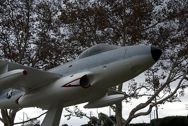
One flag took us to a residential neighborhood just around the corner from the Great Western Forum, former home to the Los Angeles Lakers and Kings. Another took us to the track of a junior high school in Santa Ana, California where I grew up and the third would have taken us right in the middle of a busy street in Stanton. That's the nature of these virtual flags. You never know exactly what you might find there since they get generated randomly by the computer program. Sometimes I've had to hike for them, other times, they're just by the side of a road.
Interspersed with these flags were four virtual caches that I hadn't found yet in the Los Angeles area. The very first one looked to be quite fun at first. As we were approaching the park where the cache was, I noted a large airplain up on a pedestal. Since the cache was called Airplane Park Cache, it made sense, so I noted to the Tadpole that it looked like we were going to have to get some information off the monument in order to get credit for the find. At that time, I hadn't read the cache page, so I was a little unprepared for what we would be looking. 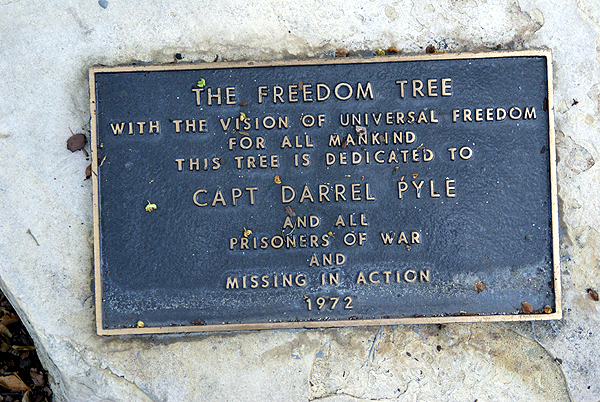
The plane was a monument to fallen soldiers of the Vietnam War who also hailed from the city of Lakewood, California. There were 42 names on a plaque attached to the pedestal of the plane and we had to find four names, all high school buddies of the cache owner and all who didn't come back from the conflict. Having never lost a buddy in war, or any other way, I cannot imagine the sorrow at losing a friend like that, let alone four. Needless to say, it put a somber tone to most of the rest of the day. Even the Tadpole was affected by my mood.
I feel these monuments are important for our society to remember those who fight to preserve out country's way of life. Vietnam was a very unpopular war. Wouldn't it be nice if we could say that all wars were unpopular? But, just because the war was unpopular, doesn't mean that we should not show the respect to our soldiers who fight in these wars. These war memorials dot the landscape all over the country. Some are well known, while others are only known by a handful of people who live near them. Geocaching allowed me to find another monument this weekend, to learn about some others who fought, those, who before yesterday, were known by two less peop0le than they are today.
As I write this, I'm also thining about my niece's husband who is somewhere in Afghanistan with his marine unit. He's scheduled to come home sometime in January. Somewhere....sometime....that's the nature of this business. We really don't know where he is and we really don't know when he's really coming home. We all pray that he comes home in one piece both physically and mentally.
Looking back at this piece, it didn't turn out to be anything like what I intended it to be. Apparently that first virtual struck a nerve with me.
Pictures were taken at or near the following geocache:
The Airplane Park Cache - by ScurvyDog

Saturday, September 13, 2008
Secret Societies
One of the things I love about Geocaching, Geodashing, and Geovexilla is they're what I like to call "Secret Societies." My daughter and I play a game when we drive around town. I'll point a spot out and say, "You know, there's a geocache over there." Her response is always, "Did you find it?"  Usually my answer is yes, but one time it was no and she made me stop and find it. Good thing I had it in the GPSr with me at the time. It's a fun game we play, but then again, we all play it to some extent. Geocachers know there's secret spots out there that only they know about, so in essence, we do have a secret society.
Finding dash points or those virtual flags is very similar but maybe weirder because there's nothing there. The points and the flags are all virtual. One of the reasons I like the latter two is there's always going to be an air of uncertainty as to whether you'll be able to score the flag or the dashpoint. With geocaching, the hard part of determining whether you can enter a spot because of private property issues has already been resolved for you by the cache hider. Not so with the latter two. The points are randomly placed by computer, so there's no way of knowing whether you'll be able to score the flag or dashpoint or not.
Today, I went to my son's cross country meet in Laguna Hills in the O.C. My plan was to do some geocaching, plus score two dashpoints and a vexilla (virtual flag). The dashpoints were both relatively easy to score,  both being on driveways leading up to houses. Since you only have to be within 100 meters to score a flag or dashpoint, it was easy to park the car at the curb in front of each house and quietly write some notes about the area for my log on the Geodashing website. I'm sure the owners of both houses don't realize they have virtual points sitting in their driveways. Hey, it's our secret society.
There was also an American Flag that I thought about getting today as well. However, if you look at the satellite images for that one, you can see that it appears to be in a green belt area of a residential community. Not a problem? Yeah, but the residential area is in a gated community, so access is going to be difficult for this one. There's that uncertainty creeping in. I think it still can be scored, but I'd have to hike to it, something that I didn't want to do today because of a time crunch. There's a possibility that I might be down there again in the near future so I'll have to investigate it again at that time.
Interestingly enough, although I expected to find more geocaches than the other two combined, today was a total wash with caching. Not a single find and that was by choice. The two dashpoints were enough today. I'll have several hours before my son's next meet next weekend to find some caches. The pictures of my son running were taken last year at another meet down in the same area.
Pictures was taken near Dana Point T-bird - by devhead and somberairokid

Wednesday, August 20, 2008
Melancholy Road Trip
This past Sunday through Tuesday I was on a road trip. Knowing me, road trips cannot be a sad time, yet this one was a little bit, since 
We found four caches on Sunday, plus a virtual United States flag just west of Visalia. The PQ I'd run for this trip was heavy into larger sized caches because I had a dozen travel bugs that I wanted to distribute. Micros don't work well when you're dealing with travel bugs although I did find a micro on Monday that was large enough to hold a small travel bug. One cache was a virtual near the old city courthouse in Merced, CA but in all of the other caches we found, we dropped travel bugs. My daughter even found one of the caches. Now she would be the first to admit that she's not much of a cacher. She says she likes the idea, but doesn't have enough time to go out and look for them. But she was very excited when she spotted Preferred Cache and every time we mentioned to others on this trip we went caching, she made sure it was known that SHE found that cache.
Monday morning was devoted to unpacking the van. Why is it when ever you're moving someone, that person always has the room that is farthest from the staircase and is on the third floor of the building? 11 trips later, we had the van unpacked. My work was done. So I just sat in her room and logged my caches from Sunday while she unpacked all of her boxes and made her room a home. After lunch, I went caching while she decided that she needed to hang out with some friends.
The caching on Monday was very good. I found several large ammo cans in which I deposited more travel bugs and I also nabbed two more virtual flags, getting Argentina in the back yard of a farm near Wilton, CA and the red and white banner of Canada which was virtually placed on the top of a red and white storage shed in the garden center of a nearby 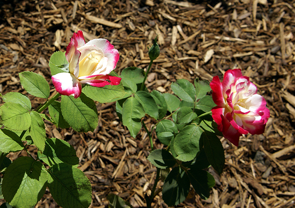
Tuesday, it was time to start my travels home. I woke up, showered, went to breakfast, then dropped by her room again, said good bye to her and went back to my hotel, packed and drove home. Although we view this house as home, it dawned on me yesterday that Pacific is her home. She was in her element there and it was really fun to see the change from last year where she really clung to us and hung back, not wanting to get too far away from either of us during parent/student orientation. T
So the trip home was sad, but I enjoyed the solitude. The caching was enjoyable Tuesday as well. I chose a different route going home because there were a couple of dash points that I wanted to get, so I took Hwy 99 for the first leg, but diverted to Hwy 41 south of Fresno, connecting eventually back up with Interstate 5 at Kettleman City. I got the two dashpoints plus some more caches along this route. It was a good day to be alone with my thoughts as I pondered what it will be like next year, when I help two kids off to college. I listened to a CD that she burned of oldies and some of her music on the ride. 
Pictures were taken at or near the following geocaches:
Fig Tree View - by Oldhippy & Granny
A Walk to Remember - by George and Mary
Wilton Memorial Rose Garden - by DiaU
Red & Green's Travel Bug Hotel - by Delawares Blue Hen Chicken
The Grangeville Zoo - by Great Scott!

Friday, August 15, 2008
Math and GPSrs
A couple of days ago, I took the Tadpole and went out to find a couple of flags for GeoVexilla. As luck would have it, there were three caches near one of the flags so we attempted to get those as well. We found a 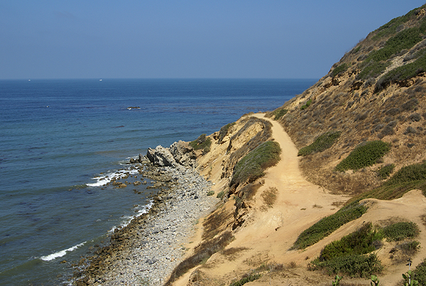
The next flag was a Uzbekistan banner located on a bluff overlooking the Pacific Ocean in Palos Verdes Estates. Most of the homes in this area ranged from $5 million to probably way over $10 million dollars even in today's depressed economy. Getting this banner looked to be pretty straightforward based upon the Google maps and satellite images. Once we got to the bluff, I realized that I might have a dilemma on my hands. I was within 325 feet (256 feet to be exact) distance horizontally from the banner, but the problem was the banner was not directly horizontal away from me, but down the bluff toward the ocean. Now, do I need to be at least 325 feet vertically as well? I hadn't run across this before on the site and I've since found that once you're within scoring distance, it doesn't matter whether you're vertically ok, as long as the GPSr says you're within scoring distance, you score the points.
I didn't know this, so I attempted to get closer. We could see a trail down along the ocean, so we went in search of the trail head to get down there. 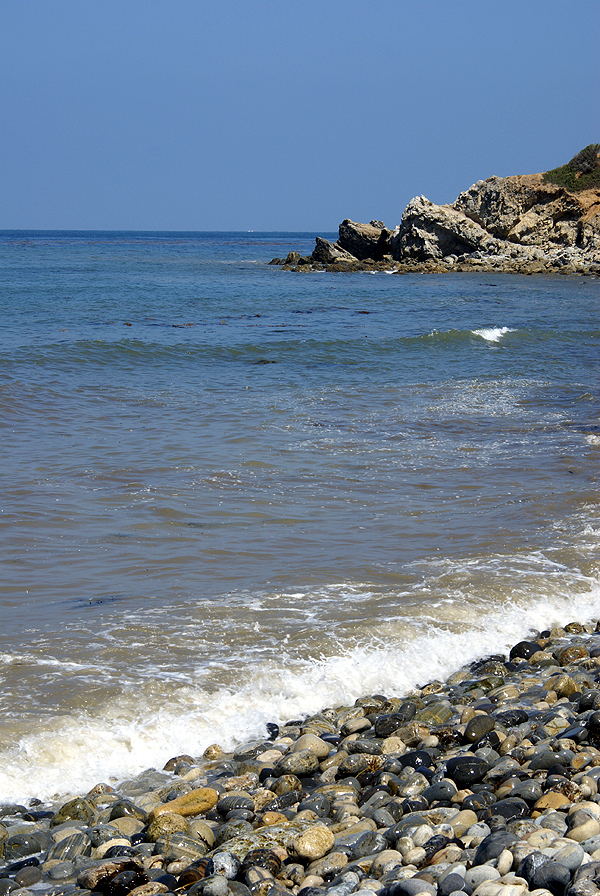
The trail became one of those teachable moments while we were looking for a way to get closer to the Uzbekistan flag as well as two other caches that were located down there. I noticed the beach was very narrow at this point, and not knowing the tide schedule, I made sure that he never put his back to the ocean while we were on the beach in case a rogue wave came or the tide starting coming in. Once down on the bluff, we found another trail that took us further up the bluff and closer to the flag. We were able to get 178 feet away from the flag at that point while being 34 feet above sea level (the bluff above was 297 feet above sea level). That was our closest approach to that flag, so I figured that I'd rely on my mathematical abilities at home to see if I would score.
We then proceeded to look for a very nicely camoed ammo can along the bluff plus a virtual cache located down there, finding both. There was a memorial bench to a surfer who had died and had his ashes scattered down in that cove which the Tadpole used to contemplate the ocean for several minutes before 
Once home, after a slight detour to get the last flag, I set down to figure out the math for the Uzbekistan flag. It was more mental exercise than anything else, since I figured that I was about 100 feet or so away from the flag from the lower end, just looking up the slope, but I wanted to make sure. Working out a drawing, I calculated the vertical and horizontal distance of my triangle, but I needed the hypotenuse of the triangle, which would be the line leading from the bottom point up the bluff to the top of the bluff where we had been standing previously. I found a site that helped me out with some of the math, since I'm a little rusty, having not done this type of math since probably college. When the calculations were done, I found that the flag/point I was looking for was 102 feet higher than me when we were down at the bottom and 154 at the top. The hypotenuse of the triangle yielded distances of 308 from the top and 205 from the bottom, both were within scoring distance, so I was good.
The day turned out quite pleasant down at the ocean. The Tadpole and I got a good hike in, we found three flags and three caches while on the hike, got to see some nice scenery and the Tadpole learned a couple of safety considerations. Not a bad day at all.
Pictures were taken at or near the following geocaches:
View to a Thrill - by seaglasspirates
Surf Refuge - by Windzombie
Flat Rock View - by Jonaz

