My last cache hide was a multi-cache hidden up on my favorite trail. It's now been hidden for over a month and has a grand total of two finds, one of which is the beta tester who went with me when I was laying out the final coordinates. 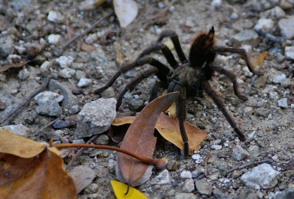
The reason why I bring this up is while on that hike, CraigsOutside and I encountered a tarantula on the trail. That's not necessarily surprising since the area is know to have tarantulas, but what is surprising is before that hike, I've seen a tarantula in the wild only one other time and it was about 2 weeks before that when I spotted two others.
One was on the trail and was actually discovered by a couple of bicyclists coming down the hill. One stopped about 50 feet up the trail from me and pointed it out to his riding partners who were behind him. By the time I got up there, it was just ambling across the fire road. Later on that same hike, I nearly stepped on one at ground zero of the first stage of my multi-cache. If that doesn't get your adrenaline up, nothing will I guess. Either that, or you're just a calmer person than I.
I've encountered my fair share of creepy crawly things while out geocaching. I've spotted snakes from time to time. Once, while out hiking we came across a very large rattlesnake. Unfortunately, it wasn't really pleased with us being there, but there wasn't a whole lot we could do about it at the time, since we had it surrounded on a couple of sides. We did the best thing we could do and that was to back up and make wide circles around it. This snake encounter was in May, when the environment is becoming more habitable for all creatures in this area, but particularly reptiles, since they rely on the air temperature for warmth.
My friend CraigsOutside was bitten last year by a rattlesnake (read about it here). 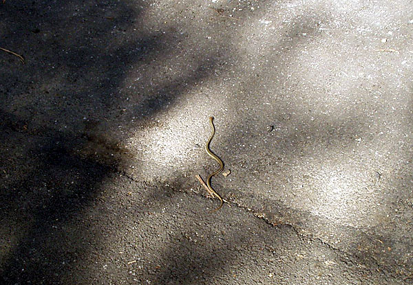
Before last year, I wouldn't have had rattlesnakes on my mind at all in November or December or any of the cold months of the year. Craig's encounter had me a lot more cautious yesterday while I was looking through a pile of rocks on the side of the road. I keep thinking that I really should get a hiking stick of some kind to carry along with me. Many of my friends take one along when we go on hikes. I've never found the need to carry one, mainly because it's one more thing in your hands while you're walking. Maybe I need to rethink that.
I'll be hiking out in the desert over the next couple of months. It's the most pleasant time to be hiking out there. It's cool and comfortable, much more pleasant than during the middle of the summer time. There's another figure out in the desert that we're going to create. I've written about the Smiley series and the Groundspeak logo in the past. Now, in the same general area to the west of the Smiley Series is a large PacMan. There are 30 caches, plus one mystery which makes up the eye of the PacMan. I have this feeling after we go out and find all of those, we might be singing "PacMan Fever" for awhile.
It appears as if each cache is about two tenths of a mile from the next cache, meaning this will be a 6 mile hike. That will make for a good hike if we do it all in one day. If we spread it out over two days, it'll be two good hikes. Anything over a mile is a good hike, in my opinion. And since one of our proposed hiking dates happens to fall on one of my open cache dates, that's always a bonus.
Pictures were taken at or near the following geocaches:
Give or Take 20ft - by madmaxxawr
Curiouser and Curiouser - by Terra Girl, Bean Dog, and my faithful sherpa Max
Sunday, December 5, 2010
Desert creatures and other things

Monday, April 19, 2010
Desert Rats
There are a lot of people who enjoy the solitude of the desert and many of them have bought parcels of land out there where they can enjoy that solitude. People who live out in the desert, in my opinion, are a different breed of people. 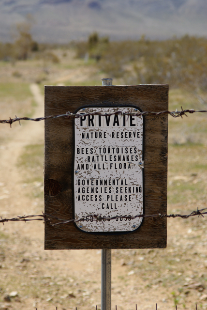
Every now and then, when I go geocaching out in the desert, I'll come across a small house, or possibly a trailer of someone who wanted to get away from it all. Obviously, geocaching has brought the "all" to them, and thus their solitude is sometimes intruded upon. Other times, it's possible just to see hints of the desert rat's life. If they really want their solitude, they can erect a fence around their plot of land. Good fences make good neighbors, even if the nearest neighbor is miles away.
We encountered a couple of these out in the desert recently, but my favorite was the Leapin' Lizard Mine. That's what it was called, although I suspect that the owner had placed that sign out there more as another barrier to keep people away from their sanctuary. The dangers of abandoned mines and open shafts are kept in the forefront of most people who go exploring in the desert. On a recent hike, we saw several mine tailings on the side of the hill we were walking next to. The open mine shaft was also sometimes easily discerned. We found a pit, surrounded by chain link fence. I made sure the Tadpole kept his distance from that one.
The Leapin' Lizard Mine was a large plot of land that we encountered while hiking the Groundspeak Series. There was a chain link fence around the entire claim and the gate had multiple signs on it warning us to keep out. As far as I was concerned, that's usually what a fence signifies out here. Keep Out.
The owner also had a sign indicating that the enclosed area was a wildlife sanctuary for desert fauna, particularly rattlesnakes and desert tortoises. I think that's a very noble cause. I had a desert tortoise (permitted) living in my back yard. I feel like I'm helping an endangered species ward off possible extinction. As we continue to encroach on these animal's homes, their living spaces shrink and we'll see less and less of them in the wild. I've never seen a desert tortoise in the wild. The one in my back yard can't be returned to the wild, as that is against the law, but I can own it as long as I have a permit for it. And so it goes.
But I digress. 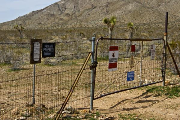
Pictures were taken at or near the following geocache:
Groundspeak Series - Stealth - by HDGC

Friday, March 26, 2010
Dry Bones
No matter how prepared you are, the desert can be a pretty inhospitable place. We had cell phones, we had plenty of water so we weren't really worried about ourselve, yet we found evidence in our last couple of weeks out in the desert that it can still be cruel to those that don't have these luxuries.
I noticed from some of the other logs that are appearing on some of the caches we found the first weekend out at the Groundspeak series that several of the cachers found the same thing as we did; dried out bones. The first thing I noticed as we approached the cache was a pelvis, bleached by the sun, completely free of any sinewy material that would indicate that it hadn't been out there for a long time. These bones were picked clean, so they'd definitely been out there for awhile.
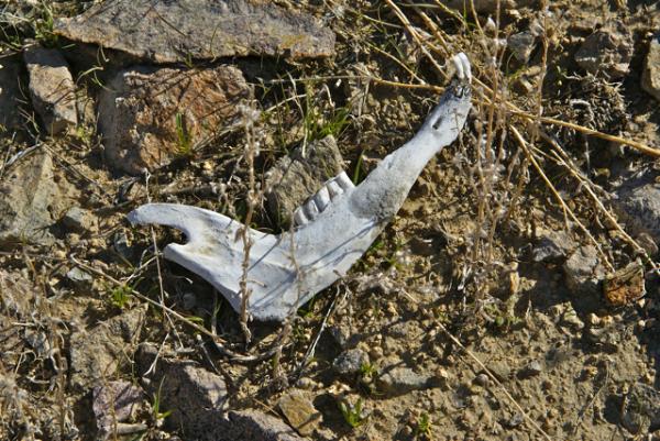
Near the pelvis, we found two sections of vertebrae, fairly intact and two long bones, what I thought to be thigh bones. The sizes of the long bones gave me the impression that this particular animal was probably a coyote. But then, we found a jawbone which messed up those theories post haste.
The jawbone was of a herbivore. Cutting teeth in the front, with molars in the back for chewing, with no canines for ripping like you'd see with a carnivore or possibly an omnivore like a desert wild pig. The size indicated a deer, but I was puzzled since deer aren't usually found here. Yes, you will see them, but they're usually found at higher elevations where the food is a lot more plentiful.
There were a lot of green plants around, but it's spring time in the desert and it's expected that green plants will be around. They will flower soon, produce their seeds which will be scattered by the wind and then they will die, only to come back after the winter rains. There is not much food during most times of the year out here, so it still didn't make sense. 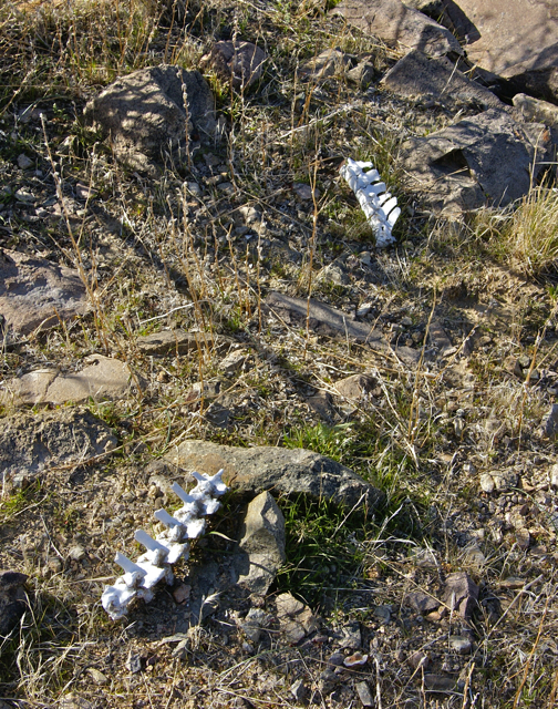
Whatever the possibility, it gave us a reminder that most animals don't have the luxuries that we have when it comes to our health. Death in the wild, is usually not pretty and I would suspect that very few animals die a peaceful death. The animals get recycled quickly as is the way with nature, so that they will give back to the plants what they took from them when they were living. How long these particular bones had been out there is anyone's guess. My hope is they stay for a longer period of time and aren't picked up by others as they hike through the desert. Let the sleeping bones lie.
Pictures were taken at or near the following geocaches:
Groundspeak Series - Power Caching - by HDGC

Wednesday, November 18, 2009
Desert(ed) Buildings
When you cache out in the desert, you sometimes come across remnants of things that used to be. In our case last week, we came across lots of different remnants. We came upon buildings that were barely there, somewhat there and almost all the way there. 
There were foundations of several buildings on the site, which was just off the road. I could make out a fence, with at least two gates. The main foundation of some type of homestead was still visible, and what looked like a garage of some kind, perhaps a barn just on the other side of the fence from where the main house was. It was fun to think about living out here in the desert and trying to survive. We found what looked like a well, and also a bird bath perhaps, which is what inspired Chaosmanor to name his cache.
In another spot, we came across an old socialist camp started in the early part of the 20th century. The camp lasted but 3 years or so before being abandoned because of water shortages. Apparently, the founders had miscalculated the amount of water they would be able to get from a nearby stream and thus ran out of water. Amazingly, in the short time the colony was flourishing they managed to build several large buildings. 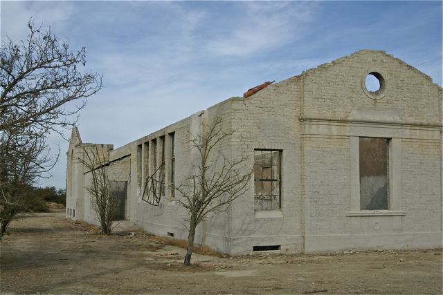
At another cache site we found a large abandoned building. We found the cache very quickly, but we stayed a lot longer taking in the building. The owner of the cache speculated that it appeared to be a Grange Hall, but he couldn't find information to confirm that. I speculated that it might have been an old church of some kind. It gave me the impression that that's what it could be, but another finder a couple of days after us found an old Topo map which indeed showed it to be a Grange Hall for the area.
Spots like this are what bring me back to the desert. Looking at the satellite photos gives you some kind of impression of an area, but when you actually get to at site, you really get a feel for what went on there. The history of an area can sometimes be told by the stuff that gets left behind.
Pictures were taken at or near the following geocaches:
The Llano Del Rio Geocache - by Kit Fox
Mystery Building - by Obtuse

Thursday, June 25, 2009
The Lure of the Desert
Living as close to the desert as I do, I end up spending a lot of time out in it. This wasn't always the case. Growing up in Orange County, we were about an hour and a half, perhaps two hours drive from the desert. My father is more of a mountain man, and so we very rarely went to the desert. 
One, our friends owned a cabin near Big Bear Lake up in the mountains and we pretty much had carte blanche access to that place. Long weekends were spent up there enjoying the mountain air. The second reason was my dad usually liked to put a full day's drive in whenever we would go camping and thus the desert always got bypassed in favor of more mountainous climes, like Sequoia or Yosemite. Now, I wouldn't trade those camping trips at all and I really didn't know what I was missing, having not visited the desert a lot, but the first place I took my daughter to when she was old enough to camp for a long period of time was Joshua
 Tree National Monument in the desert. Having a kangaroo rat dancing around your feet while sitting around a campfire is something that everyone should enjoy at least once in their lifetime.
 Yet, out in the desert you can always find homes that most people would describe as out in the middle of no where, without a paved road for miles.
  In fact, it's much easier to get away from it all in the desert than it is in the city. Out in the desert, you can see the Milky Way on a regular basis. That's becoming hard to do in our mountainous playgrounds because of all the lights we tend to bring to make our lives more comfortable when we're staying there. People out in the desert still tend to use minimal lighting. That's a good thing. We need places like this, to reconnect with the past, to look into the heavens and see the stars at night and to perhaps enjoy that kangaroo rat's dance.
4960 - by Mr. and Mrs. Wisearse
Dublins Tin Can Alley - by mtngirls

Sunday, May 31, 2009
Desert disks
Saturday, I went up to the mountains to pick up my daughter. Obviously, since this is more about the desert than the mountains, I took a pretty circuitous route to get to the mountains. In fact, it was a rather longish route, but very fun.
I've been watching a couple of the virtual flags out in the desert and noting that several of them were about to expire, so I decided that Saturday morning would make a good trip out to get them. I created a bookmark list of caches along my intended route as well, so 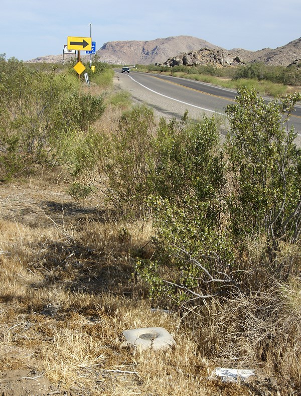
My route took my up the Interstate 15 into Victorville, then east toward Apple Valley. There I was able to score a Bhutan flag. I also found a small cache behind a movie theater. Then I proceeded east along a road the Tadpole and I had traveled in the past. My goal was to head to the northern border of Joshua Tree National Park, mainly because there was a cluster of 3 virtual flags out there, plus one nearby.
As I was traveling, I kept noticing some of the caches that had been part of my PQ show up on the screen. There didn't seem to be adequate stopping areas for many of the caches, or either I was driving too quickly to make good stops, but I was able to make one stop at a cache entitled, POINT. Team Christiansen has created a bookmark of caches in the Apple Valley that are placed near benchmarks. With 32 caches on the list, someone who is interested in benchmarks would be able to spend a rather enjoyable day out there finding caches and logging benchmarks.
After parking near POINT, I got out of my car and immediately spied the nearby benchmark. No, not just one did I spy, but three benchmarks. This was almost as good as the other cache where the Tadpole and I found five benchmarks in one spot. After finding the cache, I went over to document the benchmarks. There were three benchmarks aligned in a row just off the highway. After taking the requisite pictures of each, plus a picture of each so people could get perspective on how they looked in the environment, I checked the cache page and realized that I'd missed one. A quick survey and I was able to spot the 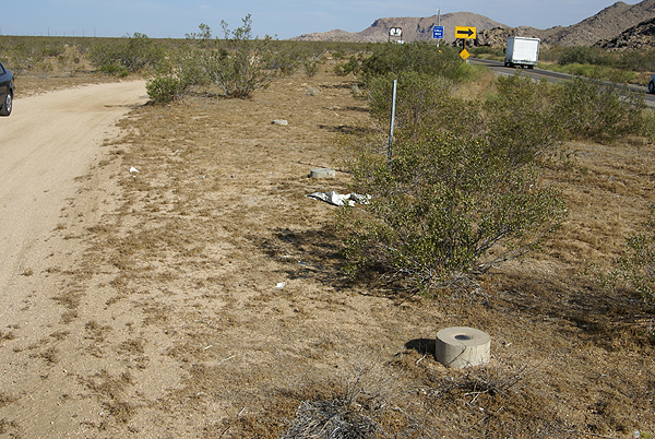
I was able to log three of the four marks. One of the marks in the line of three was a newer benchmark from 1983 and wasn't in the benchmark system at geocaching.com. The other three, arrayed in a triangle shape all dated to 1934, the year after my parents were born. I'm at a loss at this time as to why the National Geodetic Survey wouldn't have that last mark in the database yet. Yet, I encountered another benchmark once I got over to the other virtual flags that wasn't in the system either.
This benchmark, which I found 38 feet away from a hidden cache, was a pipe cap type of benchmark, driven into the ground right on the boundary of Joshua Tree National Park. The mark is dated from 1932, so it's relatively old and I was hoping that it might be in the system, yet when I checked later on, it was not to be found. 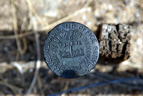
I think I'll keep these photos in a safe place. Who knows? Perhaps in the future, I'll be able to pull them out of the archives and log them when the database gets updated. From past experience, I was pretty sure I'd logged all the ones in my local area, but now it appears as if new ones are showing up in the database. This would indicate that the database does get updated from time to time. Now I just need a way to remember that I have them.
Pictures were taken at or near the following geocaches:
POINT - by Team Christiansen
Architectural Digest - by Joshua Tree Bonnie & Clyde

Monday, March 30, 2009
Desert Color
I think most people think the desert is pretty barren. I've always found it anything but and during certain times of the year, it can be pretty spectacular. Sometimes,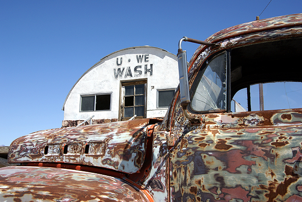
When I was out in Shoshone this past week, I found several caches that fit the bill for different types of color. One cache was hidden outside a broken down laundry facility near a campground. The campground was situated on top of a dry lake bed, which, for the most part makes it pretty barren. The laundry facility was built up on top of concrete blocks. It was a permanent building, so during times of rain in the desert, it would stay high and dry above the lake that would form after a good rainstorm.
The facility is in disrepair now, but there was an interesting old truck outside of the place. It had the neatest color composition, sort of a combination, primer, rust, old paint all blended together for some kind of surreal pop art type of vehicle. Looking at the tires, they were low, but it looked like the truck hadn't been parked there very long and could conceivably still be driven. I think it would definitely turn some heads if it had been taken for a spin. Out in the desert, it looked right at home.
At another spot I found a cache near an old cemetery that appeared to be still active. I've always been one to look at old cemeteries when 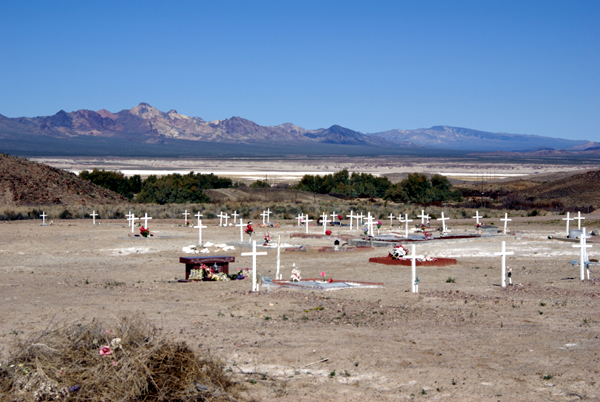
Many cemeteries in the desert tend to be located in very peaceful spots, usually with good views and this one was no exception. I remarked in my log that this particular spot would be a bad spot to spend eternity, since it had a view that was absolutely gorgeous. Although, I also noted that it wouldn't hurt me a bit if I had to wait another 40 years before I decided to take up residence in the place.
Then on Sunday, the Tadpole and I went caching in the high desert just west of Victorville. We were 
My picture doesn't do it justice, but I loved the way the ground was covered in yellow, while I could still see snow on the mountains that separated the high desert from the Los Angeles basin. In a few short weeks, this natural carpet will be gone, withered away as the temperatures start to climb to three digits. But all the seeds these flowers produce will support another natural carpet next year after the rainy season has concluded. We just got lucky this year that we happened to be in the right place at the right time.
Pictures were taken at or near the following geocaches:
Tecopa Wash-Up - by Mr. and Mrs. Rhino
Cemetery Cache - by 3blackcats
4474 - by Mr. & Mrs. Wisearse

Thursday, March 26, 2009
The art of logging
After 3blackcats and I came back from our desert run this week, I settled down to write my logs for the caches. With 24 caches, I had a lot of logging to do. 
The reason I do this, is I feel it's part of the entire geocaching experience. When the hobby first started, the caches were all fairly large. Large caches meant large logbooks and so people wrote of their experience in there and on-line. I can remember one cache I found with friends up on a ridge overlooking Los Angeles. The area was large enough for a helicopter to settle down on, which is exactly what happened. Not while we were there, but sometime earlier, because two FBI agents 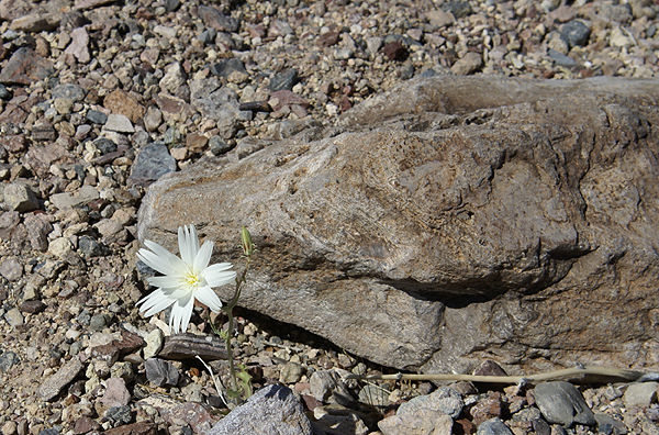
With the proliferation of micro caches and the tiny logbooks, or pieces of paper in some cases, there's hardly any room to place much more than you're name anymore so logging in the logbook seems to have gone by the wayside. I am fully guilty of not writing much in the logbook on most caches I find as well. I try to make up for it by writing something about the experience on the on-line cache page. I figure I can give any cache, even a lamppost skirt hide at least 50 words. I try to give 100 words per cache log. I'm not always successful, but I try. In reality, 50 words is easy.
And, I don't cut and paste. Each log is unique, so it takes me awhile to log all of my caches after a big day. I was logging Tuesday's run from Tuesday evening until Wednesday morning around noon. It helps that I'm on vacation, but when 
Wednesday afternoon, I received a nice email from turtle lady.
"I am the owner of Heartbreak Hotel cache in Shoshone California and I just read your log. I want to say THANK YOU for that long, well written log! What fun reading that!This email makes my logging all worthwhile to me. It just confirms that I'm doing the right thing when I take the time to log each cache individually with separate and unique comments for each log.
I get so many emails from people logging my many caches and so many of them just say "TFTC" or "Got it" and I am disappointed! ...... When I get a log like yours, it makes me want to place more caches! Not many places like Heartbreak Hotel left to share with people but I will keep looking!"
I've met people on the trail that have made comments to the effect that I write "wordy" logs. I feel that's a compliment. I want people to know my experience. I
cannot begin to tell you how many times I've read logs that have helped me find caches that I never would have found otherwise. And it's not necessarily that the previous finder posted a "It's right under the log" type of post. Many times finders write in such a way that a simple comment will turn a light bulb on in my head that will lead me to the cache.One thing that I always post at the end of each log is a thank you for placing the cache out there. If the hider went to the trouble to hide a cache, I figure I should thank them for their effort. It's simple courtesy, something that we in general can always use more of in our world.
Pictures were taken at or near the following geocaches:
Heartbreak Hotel - by Turtle Lady and Cause I Can
Dublins Tin Can Alley - by mtngirls

Wednesday, March 25, 2009
Some like it hot
I wasn't sure how I was going to title this particular entry. I thought about calling it, "I touched the Thermometer" but wasn't sure how that would go over, so I 
About two years ago, I decided to run a Pocket Query (PQ) looking for all the virtuals in my local area. I didn't know where they all were and just wanted a general idea on the whereabouts of them. As I searched the map, I came across a virtual in Baker. Baker is located along Interstate 15 about two hours south of Las Vegas, Nevada. It also bills itself as the gateway to Death Valley, because the main road that runs along the edge of the park and eventually into the park starts in Baker.
Baker is also home the World's Tallest Thermometer. It's 134 feet high, which is also the highest temperature ever recorded at nearby Death Valley. It stands as a beacon day or night. It's been standing in Baker since 1991, so there's at least six different occasions that I've driven by it and noticed the temperature on the thermometer. Since all of the times I've driven by, it was during the summer, it was probably registering in triple digit mode. But the catch is, outside of yesterday, I'd never stopped and investigated it further, mainly because there wasn't any need to stop. I remember one springtime taking my two older children on a camping trip to Death Valley and we ended up stopping in Baker to eat lunch but didn't go over and check out the thermometer.
Once again, geocaching has gotten me out of my cocoon of a car to investigate and explore something a little bit more in detail. Not that this is anything spectacular; it's just a tall tower that also happens to display the temperature at the moment. But it's the kind of kitsch like this that has always made road trips by Americans memorable. Motels shaped like Indian Tee Pees, Bedrock City, where the entire place is devoted to the Flintstones, or the Trees of Mystery in northern California are all what we would probably call tourist traps. They are places that wouldn't hesitate back in earlier days to strap a bumper sticker on to the front bumper of your car so you could advertise for them.
Well, yesterday, I fell for the tourist trap. I got out of my car and walked up and touched the thermometer. 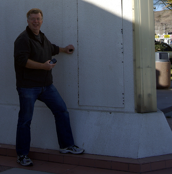
Pictures were taken at Some like it Hot - by AquaDyne

Sunday, June 29, 2008
Desert California
I would be curious to know what people outside of California think about first, when they here the word, California. 
The road that we took for that excursion last week, HWY 138, connects up Gorman, CA which is along Interstate 5 over to Lancaster, CA which is in the middle of the Antelope Valley in what is commonly called the high desert. Here in California, we have both high desert and low desert, with 4000 feet elevation being the cutoff between the two, approximately.
It's really interesting when you look at desert. Recently, I got to see some pictures of Qatar and the desert there. That's probably what most people have in mind when they think of desert. There's not much in the way of plant life and lots of rocks and sand. I think people think about sand dunes also when they think about the desert. 
We also noted the typical sage brush that is rather ubiquitous to the region, but there were also strands of joshua trees and other typical desert vegetation here. At the high elevations, there were scrub oak forests and an ocassional pine tree. One particular pine tree that we encountered was almost 90 years old. That doesn't sound like a very old tree, but when you consider the harsh living conditions, you have to think that this particular tree is actually pretty remarkable.
Growing up, I never fully appreciated the desert, probably because my father really didn't appreciate it himself. He was a mountain lover, so our vacations consisted of traveling through the desert, usually in the dead of night, so we could get to the higher up places where there were trees and water. I can think of one time when we camped in the desert for anything over a one night stand and that was when 
When my daughter was old enough, one of the first places I took her was Joshua Tree National Monument. I hauled my dad long with us, because he'd never been there either. I've been back to Joshua Tree a number of times since then. It's a beautiful place, full of all the things that make the high desert wonderful. I was there last November with my youngest son for his first excursion there. He loved it as well and wants to go back again in the future.
There are other things that we have in the desert here that I won't go into here, but will save for another post. It was one of those unexpected things 
Pictures were taken at or near the following geocaches:
Gorman Road - Wild Flowers - by fOtOmOm
Just Ducky - by Searching Gentiles
Quail Lake - by fOtOmOm
Desert Wind - by hoolegan & BIOB

Sunday, May 4, 2008
Solitude
Yesterday, I got to experience something that rarely happens to most human beings, that rare time when you are by yourself and you're all alone as if you're the only person on the face of the earth. Granted, I was with my friend Chao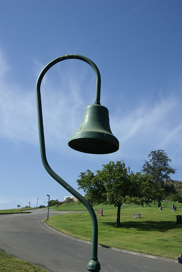
With my introduction into new GPS games, we both decided that a road trip up into the high desert north of us was in order, so we set out on a 322 mile road trip yesterday, making an entire loop around the San Gabriel mountains. We started out in Pasadena and took Highway 14 north toward Palmdale, stopping a couple of times to grab a cache, plus a couple of virtuals as well. We saw an old bell from the old El Camino Real, the King's Highway at one of the virtuals. We were also trying to get several flags in the GeoVexilla game, plus a couple of dashpoints for GeoDashing as well.
Most of the morning was spent caching. I got my 1900th find on a nice travel bug hotel just off Highway 395 which runs through the desert and east of the Sierra Nevada mountain range all the way into Washington State. I'll have to keep that particular hotel in mind the next time I head on vacation up that way as it's an easy on and off and great spot for a travel bug hotel, without any of the silly "take one only if you leave one" restrictions that some bug hotels have on them. Those are prisons, restricting the travel of the bugs, but that's an entirely different post.
After lunch at the local nationwide hamburger place, we decided to get some flags and dashpoints. Our last dashpoint of the day took us out northeast of California City, which is a huge city (land area-wise) out in that part of the desert. Google maps says that the city is east of where we were looking for the dashpoint, but in re
The interesting thing about Geo Vexilla and GeoDashing is there is a certain degree of uncertainty about each hunt. It's similar to Geocaching, yet there still more uncertainty, because you never know what you might run into when you're on the ground, even if you have really good Google Satellite images to look at. The detail of those can only be so good. With Geocaching, you know that at least one other person (the hider of the cache) has already been out there. In Dashing, the likelihood is, no one has been out to this particular spot before, so it's all new territory to discover.
This is where the solitude comes in. The roads out in the desert, for the most part are dirt and you can only go so far before your smarter senses take over and you realize that you need to park the car and walk, otherwise your car and you might get stuck. I do not own a four wheel drive vehicle, although I freely admit that it's one of the many toys that I've lusted over in the past couple of years. So I was taking no 
We knew the solitude had to end, because we had to get back to civilization. On the way back to my car, we started seeing different kinds of insects, plus a couple of birds. It was almost as if the animals wanted us to share in their solitude by being absolutely still for us on our trek out. Or was it the other way around and we were intruding on their solitude? Either way, the solitude was broken entirely by the time we got back to our car, because at about that time, a dirt biker went flying across the desert on his bike, on one of the many trails that criss cross in the area. So much for that quiet solitude, but it was nice while it lasted.
Once back in the car, we headed back toward civilization, finding a couple of other caches along the way. I spotted a partial California Desert Tortoise shell. It was a very large shell. I estimate the carapace was at least 12 inches across. I have a couple of these guys in my back yard (they are permitted as per law) and they're not nearly as la
Caching and hiking in the desert always seems to bring out new experiences for me. The vistas are always impressive although it was disconcerting to see the Los Angeles smog creeping out there. The view was a little bit hazy as a result. It looks like we missed the peak blooming season for wildflowers out in the desert by about a month, be we were still able to catch glimpses of mesquite in bloom as well as some desert mallow. All around you, there is life, even in the most inhospitable places like out here. And in the back of your mind, 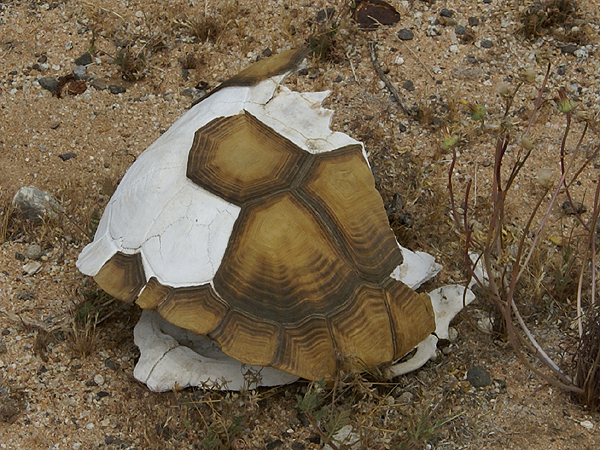
We made our way down Interstate 15, through the Cajon Pass and then skirted the San Gabriels on the south heading back toward Pasadena where Chaosmanor's car was parked. The trip down was a little quieter, perhaps because we were being a little bit more introspective after our trip into the desert. I'm willing to bet that it was really because we were both tired, more than anything else. It was a good day.
The first and last photos are from the following geocaches:
Pioneer Cache - by AlphaCat with help from The Boy and CC-Cat
Ma Greens General Store (Formerly) - by Team Berge (Thanks Ma Green)
The other pictures are from the Dashpoint out in the desert near California City. Thanks to Chaosemanor for taking a picture of me at ground zero of the Dashpoint.

