This past week, I went on a short road trip to Northern California. I know short is a relative term, but it was short for me in time, as opposed to distance since I put slightly over 1000 miles on the van, plus added two new front tires during the trip.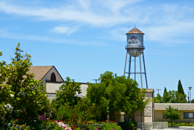
I drove up to Stockton, mainly to deliver extra "stuff" to my daughter, including a couch that she'd gotten from her grandmother, but couldn't fit in her car. There would be a side trip to Santa Cruz to pick up my son as well. Since he wanted to visit with his sister for a little bit, I picked him up, then drove back over to Stockton. This should have been a 4 hour round trip, but it ended up being over 8 hours because a problem developed on one of the front tires and I had to get that fixed before we could head back. Things happen and there's not much I could do about that.
Each time I drive up there, I try to take different routes. I look at the different virtual flags that can be captured, as well as any possible dashpoints, plus geocaches and then I plan my route accordingly. Waymarks and benchmarks are side possibilities, but for those, I just let them happen as opposed to me actively search for them.
If you've followed this blog for any length of time, you know that my most active waymark category is water towers. I love driving into small towns and seeing their town advertised for miles by the large water tower in the center of town. We have few water towers in Southern California, as most municipalities build large storage tanks in the hills above town which provides the same purpose of creating water pressure for the town's water supply.
Towns in the Central Valley of California and elsewhere where no hills are present create their town's water pressure by building water towers. Usually, these water towers promote the city, but some support advertisements for local businesses. The main water tower in Merced, California promotes the newest university in the UC system, UC Merced.
As I drove through the Central Valley this week, I happened to drive through the town of Wasco, CA. I've seen signs pointing to Wasco while driving both Hwy 99 and I-5, but have never gotten off, mainly because the town is out of the way. 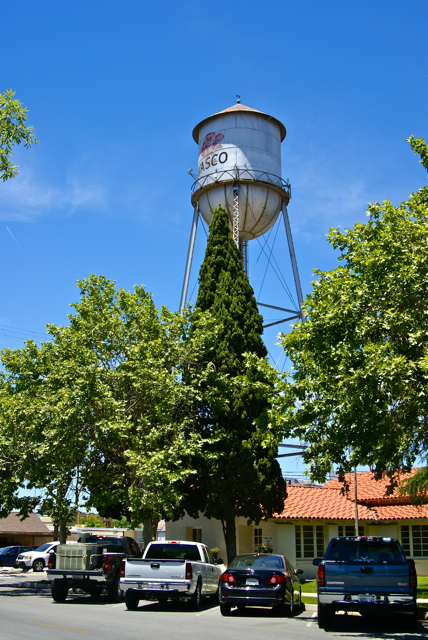
Had I known a little bit about the town, I might have been tempted to stop there sooner. Wasco bills itself as the Rose Capital of the World. Every year it has a rose festival the weekend after Labor Day weekend and the water tower in the middle of town is plastered with a large red rose. After getting home, I discovered that 55% of all roses grown in the United States are grown in and around Wasco by nine major rose companies. It was a pleasant experience to drive through the fields around town and see rows and rows of red roses, then rows of yellow roses. I know I've never seen so many roses in one place before.
If not for the GPS games that I play, I probably would have never passed through this quaint little town. I feel, I'm richer in spirit because of this hobby. If you happen to be in the area on the weekend after Labor Day some year, I think you could do worse than to make a stop in Wasco and take in their Rose Festival.
Pictures taken at the Wasco Water Tower:
Saturday, June 12, 2010
A rose by any other name...


Thursday, June 3, 2010
Where is that thing?
Every now and then, I will come upon a cache that I feel is just well done. That was the case last weekend with East Canyon Log-In. The coordinates were slightly off on this particular cache, but being thirty to fifty feet off in a rural setting is a lot different in many ways to being the same distance off in an urban setting. 
What helps is the cache page write up, which is one of the reasons I really liked this particular cache. If you go to the cache page, you'll notice that I've placed it on my top 5% list. Making my list in no way implies that the cache is a great cache. It only means, that in some small way, it either tickled my fancy, or I felt it was creative in some way. This one, I think, did both.
The cache itself, is a small jar, which would be difficult to spot in thigh high foxtails and thistles. However, the cache page write is very much like a decrypted hint in helping the finder find the cache. I'm not saying that's necessary all the time, but it sure is helpful, especially when you have tree cover that reduces the accuracy of the GPSr in your hand.
The second part of this cache that I really liked was the cache container. As stated is was a small jar, but what way the jar was incorporated with the surrounding environment helped get this cache onto my list. I actually would have wanted to be a fly on the nearest tree when the cache hiders brought this cache here. I think it would have been very entertaining.
The only other question I have is, where do you think the cache is hidden? It might be obvious, or it might not be.
On a side note. Some of you might have noticed that I've gone to moderated comments. I have done that because recently, I have been getting spam comments. Obviously, the person who has been doing this hasn't gotten the message and continues to post links to pages that I would find objectionable if my youngest were to click on them. Since he reads this column from time to time, I felt it necessary to go to moderated comments. To that person - if you continue to reply to this blog with links to semi-pornographic sites with no other intent other than to generate traffic to your own site, your posts will continue to be summarily rejected. I apologize to my other readers for this action, but I feel it is necessary to keep this a family friendly blog.
Picture was taken near East Canyon Log-In - by BearandDirtybird

Monday, May 31, 2010
Personal challenges
I think most people challenge themselves for their own personal satisfaction. When I was younger, I used to challenge myself to improve upon my model making ability, usually by being more careful and patient (probably the best way to improve in model making), or by trying to build harder models. My painting ability was never very good, so I worked on that. Sometimes, I was satisfied, other times I wasn't.
I do the same thing with my photography today. It's much easier now, in my opinion, to take good pictures in the digital age than in the film age. Once you take a picture, you can view it and see if there needs to be adjustment immediately. Other adjustments can be done on the computer with a variety of photo editing software. I still try to improve and challenge myself to take better pictures. Composing behind the lens is important to me and for the most part, I like the results I get.
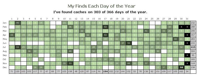
This next week is going to be the first major challenge for me. As you can see, I have five open days in the next six. At first, I was kind of surprised when I looked at this for the first time earlier in the year. Why is June, especially early in the month, so cache empty? The answer is readily apparent if you know my profession. The end of the year for a teacher is usually hectic and incredibly busy. With the school year shifted over the last couple of years, I'm now out earlier in June. This might open up some opportunities for me to go caching that might not have happened in the past. This week is my last week of the school year, so we'll see if I can get out and cache.
The same can be said, even more so, for the beginning of the school year. I have 10 open days in June. In September, I have 15 open days. It's just too hectic at the beginning of the school year to attempt any kind of caching other than on a couple of weekends. That's probably why I only average less than 10 finds for the entire month of September over my entire geocaching career. Contrast that with July where I average 45 caches for the month. Summer vacation does afford me more time to pursue my hobbies, that's for sure.
The two hardest days for this upcoming week will be the next two. Those are the last two full days of school. I should be able to leave school and at least get one local cache for each of those days. There is a new cache just north of my school that was hidden recently that I would like to find, but I think I'm going to wait until Friday for that one. This particular cache is placed only 189 feet away from where my second hide had been hidden when I lived closer to where I work. When we moved out of that house, which overlooked the cache site, I archived the cache. It was fun to watch geocachers looking for my cache. I think I'll check out the new cache sometime this week.
So I guess the only thing left to do is to wish me luck on this endeavor. I have 63 open days and if I'm successful, I'll have every square on the grid filled next February 8th.
Graphics created using My Geocaching Profile.

Friday, May 28, 2010
Broken Benchmark

I think one of the reasons I didn't enjoy benchmark hunting at first is because when I "discovered" benchmarking, I immediately went out and tried to find the closest benchmarks to where I lived, only to come up empty on four or five attempts. Being a rookie to this particular GPS activity, I didn't know all of the ins and outs at the time. I'm not saying that I do now, but I understand what to look for and how to look better than I did 6 or 7 years ago.
The first benchmarks I went hunting weren't there, because of the federal government. The Feds didn't destroy them, rather other agencies probably inadvertently destroyed them, while complying with the American Disabilities Act (ADA). I had been looking for disks attached to curbs. When streets had been widened or worked upon, the curbs had to be made wheelchair accessible. New curbs were laid and the old curbs, which had the benchmarks attached to them were discarded.
In urban or suburban areas, I would suspect that many early benchmarks disappeared because of new construction all the time. In rural areas, without as much construction, benchmarks tend to last longer, which is why I find most of the markers on my list out in the desert. The marker that Chaosmanor and I went searching for was out in the desert, so we assumed that we'd find it in the ground where it should be according to the description listed on the benchmark page.
We were sadly mistaken on this account as we found the benchmark, attached to its concrete post lying on the ground. The benchmark was in the general vicinity of where it was supposed to be, but some kind of construction, or possibly a farmer tilling his field had pulled the post out of the ground.
Because there hadn't been any kind of report on this benchmark in over 40 years, we can only speculate as to when this took place. We both estimated that it had been several years at least that the benchmark had been in its present condition. 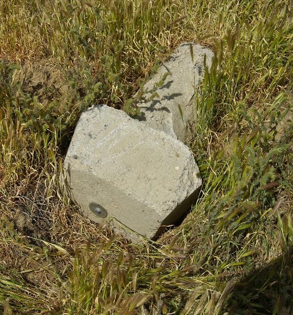
I'm going to assume that whoever pulled it out of the ground had one of those "Oooops" moments and didn't want to risk a fine, so decided to leave well enough alone and just disappear back into the desert environment. With that assumption, the hole would have slowly filled up over the course of a couple of wet winters and there would have been little evidence of where the post should have been in the ground. The post is about 3 feet in length, so three or more years would have been minimum I think to fill in a hole. Then again, the person who pulled it out, might have helped it along by refilling the hole.
Overall, the benchmark is in pretty good shape. It's just not useable the way it is, because it's not in the right spot. At least with a little detective work, we've been able to piece together a little bit of its history over the past 40 years.
Pictures were taken near the following benchmark:
EW0888

Thursday, May 20, 2010
For the Birds
What you see is a picture of a birdhouse. Nothing much really to tell about it, other than the occupants of said birdhouse didn't want their picture taken that day. This birdhouse was quite close to a cache and it worked well as, what I liked to call, a distractor. 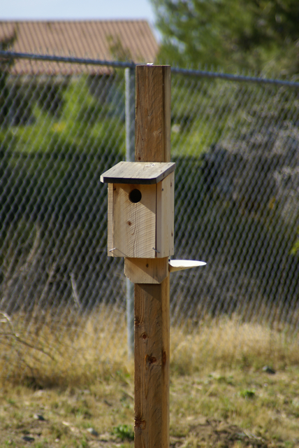
When you think about it, we tend to look like loiterers when we geocache. It's hard not to look like you're loitering when you're hanging around a bush by the side of the road and every now and then you end up putting your head inside the bush. I spent the better part of an hour inside a bush last Saturday and ended up with a DNF on that 4 icon challenge cache. Come to find out it was muggled. The owner has promised to have it replaced by the time I head back up there next weekend.
But, back to the birds. As I said, this birdhouse was in the perfect spot for cache hunters, because it provided a reasonable purpose for cachers to be in a particular area, in this case a parking lot. While we were looking for the cache, we ended up seeing a groundsman drive past us. We weren't questioned because we made it look like we were enjoying the flowers and taking pictures of the birds, which is really what I was doing. Had the birdhouse not been there, it would have been more difficult to justify our presence there.
The Western Bluebirds, that were inhabiting the house, apparently didn't want their picture taken. It seemed like each time I raised my camera to take a picture, either the male would fly off from the perch, or the female would duck her head back inside. And of course we had one of those, "wouldn't you know it" moments, because as soon as we were back in our car and leaving the area after finding the cache, both birds were outside the house. Maybe next time.
Picture was taken near the following geocache:
TOMORROW NEVER KNOWS - by BEATLES CREW

Thursday, May 13, 2010
Icon Challenges
Chaosmanor sent me an email last week entitled, "If we'd only known." In it, he detailed a challenge cache that was all about the icons. In other words, you needed to find, in one day, six different kinds of geocaches to qualify to find this particular cache. We didn't know about this cache on Saturday May 1st when we went to the 10 Years event at the Devils Punchbowl, so we didn't go out of our way to get a bunch of different kinds of caches. The caches just came naturally that day.
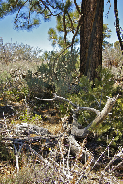
My son and I are also going to attempt the 6 icon challenge this summer. Our planned route takes us through Lassen Volcanic National Park, close to Redding, CA. Many of you may already know that the GPS Adventure Maze Exhibit is in Redding through September at the Turtle Bay Museum. This particular exhibit offers it's own special icon. With that in mind, we have planned an earthcache in Lassen, then will drive down to Redding, getting a traditional, and a virtual, before heading to the museum. After the museum, there will be a multi-cache just north of the museum. All we'd have to do then is find a mystery cache to complete the challenge. It should be a fun day, even if we don't finish the challenge.
I think this is one of the things that keeps me going in Geocaching. I've had other hobbies that have waxed and waned over time, but I seem to have kept an interest in this hobby much longer than others. Perhaps it's the little challenges that keep me going, keeping the hobby from getting stale. Either that, or it's just something that I like to do. I would be willing to bet that it's a combination of both of the above. Either way, I'll continue to watch for these kinds of caches.
Picture was taken near the following geocache:
Devil's Punchbowl - by Kit Fox

Sunday, May 9, 2010
Winter's last gasp
Every now and then I just marvel at the diversity of life in California. You can be at the beach in the morning and on top of a fairly tall mountain within in a couple of hours, or out in the desert rock hounding. It has an amazing array of scenery. This late in May, it's also extremely rare to see much snow on top of the mountains, unless they are the Sierra Nevada. Those mountains, which create the geographic backbone of California run as high as 14,000 feet. 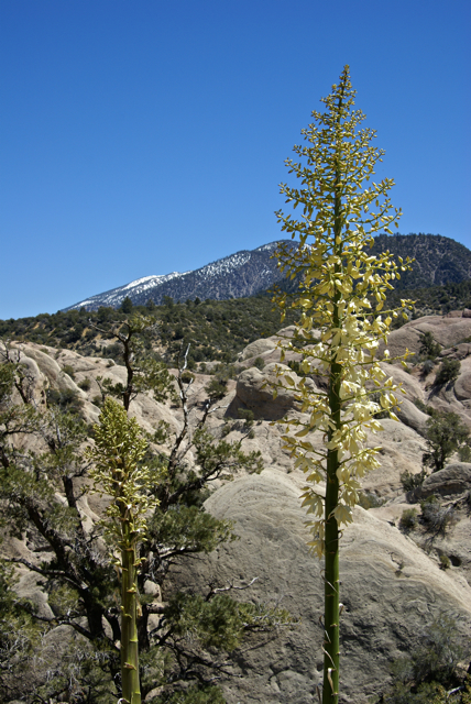
Still, in May, we usually only see a sprinkling of snow in few spots on our local mountains. Not this year, because we received several very cold storms in April. The storms dumped snow at around the 5000 foot level and it's still there, not in copious amounts, but enough to notice if your hiking in view of them. That sometimes lends itself well to interesting pictures. While on a hike in the Devils Punchbowl, I ended up getting, what I think is a pretty decent shot of a yucca in bloom with the snow covered mountains in the background.
In a month, the snow will be gone, although based upon today's weather, which was cold and dreary, but with no rain, it's not out of the realm of possibility to see more rain storms. We have been having warmer, rather than colder weather over the last week or so and I ran the sprinkler system on the lawn for the first time last night, so I think we only have two chances of getting more snow on the mountains this season and that would be slim and none.
I'm now trying to figure out when to take my camping vacation this summer. The plan is to camp at Lassen Volcanic National Park this year. I've been to Lassen probably 3 or 4 times, but I've never been able to get to the top of the mountain. It's not a real tough climb, but it is 11,000 feet and because the park is much farther north, there will be more snow on the peak, especially this year. Because of when work starts in August, I don't have the luxury of waiting until then when it's quite warm and probably snow free, so we'll have to take our chances with the snow. But, as my son says, "It's an adventure." Snow, or no snow, we'll be there sometime this summer.
Picture was taken at or near the following geocache:
Devil's Punchbowl - by Kit Fox

Wednesday, May 5, 2010
To each his own
The nice thing about hobbies is everyone can enjoy them at their leisure and no one needs to be recruited or feel that you're out of step if you don't partake in a particular hobby. Just like everyone else, I dabble in a variety of activities that keep me relatively busy. 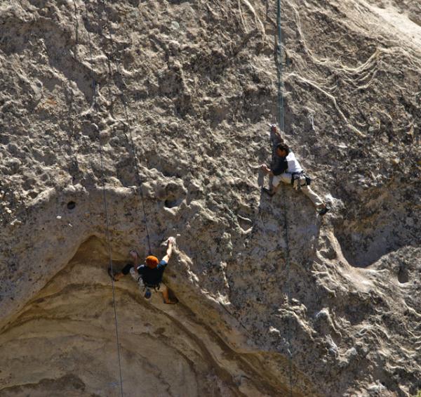
As we were hiking this past Saturday in the Devils Punchbowl, we stopped several times to watch some rock climbers on the opposite side of the Punchbowl work their hobby. Even with my acrophobia, I considered this particular sport at one time when I was in college. Several of my friends in the dorms at Humboldt State University would drive up to Patrick's Point State Park and climb the rocks there on the weekends.
They invited me to go on one of their excursions one time and I incredibly, now that I think of it, accepted. One friend let me borrow his climbing shoes and another friend set me up with his climbing harness and soon they had me hooked up, on belay and climbing up the face of this rock. First thing they had me do was fall. I had to know that I could depend upon them to brake my fall. That, actually, was the hardest thing about the sport. That initial rush, or rather, the trepidation of just letting go of the rock probably scares a lot of people off the face of the rock more than anything else.
Once I passed that test, it was on to the actual climb. The rock that they would climb was probably no more than 50 to 75 feet to the top. There was a parking area on top, complete with railing and viewpoint, so it made a perfect place to anchor in the ropes. Then, they would drive down to the bottom of the rock and practice different ways to climb the rock, trying different techniques to improve their abilities. The rock was pretty much vertical, so it was a good test for most rock climbers learning their craft.
I started up and was doing pretty well, getting encouragement from my friends while I tried different routes. 
Pictures were taken at or near the following geocaches:
Burbling Brook - by steveel
Devils Punchbowl - by Kit Fox


