I think most people think the desert is pretty barren. I've always found it anything but and during certain times of the year, it can be pretty spectacular. Sometimes,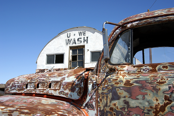
When I was out in Shoshone this past week, I found several caches that fit the bill for different types of color. One cache was hidden outside a broken down laundry facility near a campground. The campground was situated on top of a dry lake bed, which, for the most part makes it pretty barren. The laundry facility was built up on top of concrete blocks. It was a permanent building, so during times of rain in the desert, it would stay high and dry above the lake that would form after a good rainstorm.
The facility is in disrepair now, but there was an interesting old truck outside of the place. It had the neatest color composition, sort of a combination, primer, rust, old paint all blended together for some kind of surreal pop art type of vehicle. Looking at the tires, they were low, but it looked like the truck hadn't been parked there very long and could conceivably still be driven. I think it would definitely turn some heads if it had been taken for a spin. Out in the desert, it looked right at home.
At another spot I found a cache near an old cemetery that appeared to be still active. I've always been one to look at old cemeteries when 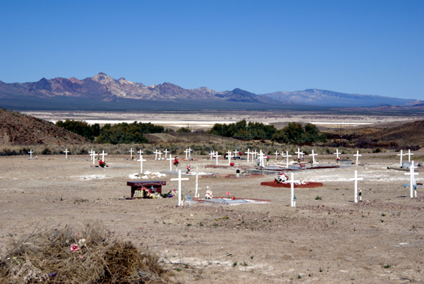
Many cemeteries in the desert tend to be located in very peaceful spots, usually with good views and this one was no exception. I remarked in my log that this particular spot would be a bad spot to spend eternity, since it had a view that was absolutely gorgeous. Although, I also noted that it wouldn't hurt me a bit if I had to wait another 40 years before I decided to take up residence in the place.
Then on Sunday, the Tadpole and I went caching in the high desert just west of Victorville. We were 
My picture doesn't do it justice, but I loved the way the ground was covered in yellow, while I could still see snow on the mountains that separated the high desert from the Los Angeles basin. In a few short weeks, this natural carpet will be gone, withered away as the temperatures start to climb to three digits. But all the seeds these flowers produce will support another natural carpet next year after the rainy season has concluded. We just got lucky this year that we happened to be in the right place at the right time.
Pictures were taken at or near the following geocaches:
Tecopa Wash-Up - by Mr. and Mrs. Rhino
Cemetery Cache - by 3blackcats
4474 - by Mr. & Mrs. Wisearse
Monday, March 30, 2009
Desert Color


Saturday, March 28, 2009
Adding more dots
I've always been interested in maps from a very early age. I can remember being asked by my 5th grade teacher to place all the states on a map of the 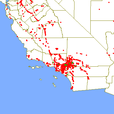
I'm not using my degree specifically, but I do use the information I learned as part of my daily curriculum that I pass on to my students in their history classes I teach. So in a way, I'm using my degree as part of my career. I'd say I probably use my degree, or interest in geography in my hobbies more so than in my career. I discovered Where's George?, the money tracking website back in its early stages in January 2000. The concept that you could track your money after you spent it and see where it went was intriguing. I've seen the money I've spent travel to every state in the United States and several foreign countries.
I can't imagine people not being interested in geography if they're at all attracted to geocaching. The entire purpose of the game is to work with 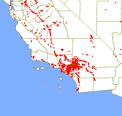
The geographic map I have in my head of certain area every now and then needs to get tweaked a little bit. I would be willing to bet that most people, if they think at all of regions of California, probably break the state up into two main regions, north and south. Earlier this week, I was caching in eastern California. Sometimes, I find it difficult to wrap my mind around that one. The state if long and lean, so I don't really think about it as being east and west, yet there I was, in what can really only be considered eastern California.
Inyo County is located on the eastern edge of the state, bordering Nevada. I knew I was east, yet when I added my cache finds to my caching map, I was surprised to see where the dots ended up on the map. I shouldn't have been, since I knew I was only 27 road miles from 
I'll continue to add more dots to this map as I continue to geocache. Expect to see more dots show up on the western side of the state. My older son has been accepted at University of Santa Cruz. Besides the regular trips I take to visit my daughter in Stockton, I'll now be adding trips to Santa Cruz as well. Santa Cruz is located near the ocean, south of San Francisco along the northern edge of Monterey Bay. You can see two cache finds on the map, one of which was a webcam cache that we found in the city limits of Santa Cruz. Our first scheduled trip up there will be next month during his spring break.
I've enjoyed the past two years watching my daughter spread her wings in college and the next few years I hope will be just as enjoyable as my son does the same. I will miss him much like I miss my daughter, but at the same time I understand that he needs to be out on his own now. He has changed so much since his geocaching days. His time with us full time is growing short. I guess I'll just have to travel more often and visit him where ever he is.
Picture was taken at THE LOST AMADEUS - by LIZARD

Thursday, March 26, 2009
The art of logging
After 3blackcats and I came back from our desert run this week, I settled down to write my logs for the caches. With 24 caches, I had a lot of logging to do. 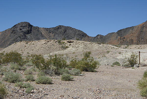
The reason I do this, is I feel it's part of the entire geocaching experience. When the hobby first started, the caches were all fairly large. Large caches meant large logbooks and so people wrote of their experience in there and on-line. I can remember one cache I found with friends up on a ridge overlooking Los Angeles. The area was large enough for a helicopter to settle down on, which is exactly what happened. Not while we were there, but sometime earlier, because two FBI agents 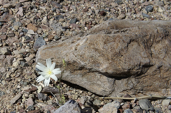
With the proliferation of micro caches and the tiny logbooks, or pieces of paper in some cases, there's hardly any room to place much more than you're name anymore so logging in the logbook seems to have gone by the wayside. I am fully guilty of not writing much in the logbook on most caches I find as well. I try to make up for it by writing something about the experience on the on-line cache page. I figure I can give any cache, even a lamppost skirt hide at least 50 words. I try to give 100 words per cache log. I'm not always successful, but I try. In reality, 50 words is easy.
And, I don't cut and paste. Each log is unique, so it takes me awhile to log all of my caches after a big day. I was logging Tuesday's run from Tuesday evening until Wednesday morning around noon. It helps that I'm on vacation, but when 
Wednesday afternoon, I received a nice email from turtle lady.
"I am the owner of Heartbreak Hotel cache in Shoshone California and I just read your log. I want to say THANK YOU for that long, well written log! What fun reading that!This email makes my logging all worthwhile to me. It just confirms that I'm doing the right thing when I take the time to log each cache individually with separate and unique comments for each log.
I get so many emails from people logging my many caches and so many of them just say "TFTC" or "Got it" and I am disappointed! ...... When I get a log like yours, it makes me want to place more caches! Not many places like Heartbreak Hotel left to share with people but I will keep looking!"
I've met people on the trail that have made comments to the effect that I write "wordy" logs. I feel that's a compliment. I want people to know my experience. I
 cannot begin to tell you how many times I've read logs that have helped me find caches that I never would have found otherwise. And it's not necessarily that the previous finder posted a "It's right under the log" type of post. Many times finders write in such a way that a simple comment will turn a light bulb on in my head that will lead me to the cache.
One thing that I always post at the end of each log is a thank you for placing the cache out there. If the hider went to the trouble to hide a cache, I figure I should thank them for their effort. It's simple courtesy, something that we in general can always use more of in our world.
Pictures were taken at or near the following geocaches:
Heartbreak Hotel - by Turtle Lady and Cause I Can
Dublins Tin Can Alley - by mtngirls

Wednesday, March 25, 2009
Some like it hot
I wasn't sure how I was going to title this particular entry. I thought about calling it, "I touched the Thermometer" but wasn't sure how that would go over, so I 
About two years ago, I decided to run a Pocket Query (PQ) looking for all the virtuals in my local area. I didn't know where they all were and just wanted a general idea on the whereabouts of them. As I searched the map, I came across a virtual in Baker. Baker is located along Interstate 15 about two hours south of Las Vegas, Nevada. It also bills itself as the gateway to Death Valley, because the main road that runs along the edge of the park and eventually into the park starts in Baker.
Baker is also home the World's Tallest Thermometer. It's 134 feet high, which is also the highest temperature ever recorded at nearby Death Valley. It stands as a beacon day or night. It's been standing in Baker since 1991, so there's at least six different occasions that I've driven by it and noticed the temperature on the thermometer. Since all of the times I've driven by, it was during the summer, it was probably registering in triple digit mode. But the catch is, outside of yesterday, I'd never stopped and investigated it further, mainly because there wasn't any need to stop. I remember one springtime taking my two older children on a camping trip to Death Valley and we ended up stopping in Baker to eat lunch but didn't go over and check out the thermometer.
Once again, geocaching has gotten me out of my cocoon of a car to investigate and explore something a little bit more in detail. Not that this is anything spectacular; it's just a tall tower that also happens to display the temperature at the moment. But it's the kind of kitsch like this that has always made road trips by Americans memorable. Motels shaped like Indian Tee Pees, Bedrock City, where the entire place is devoted to the Flintstones, or the Trees of Mystery in northern California are all what we would probably call tourist traps. They are places that wouldn't hesitate back in earlier days to strap a bumper sticker on to the front bumper of your car so you could advertise for them.
Well, yesterday, I fell for the tourist trap. I got out of my car and walked up and touched the thermometer. 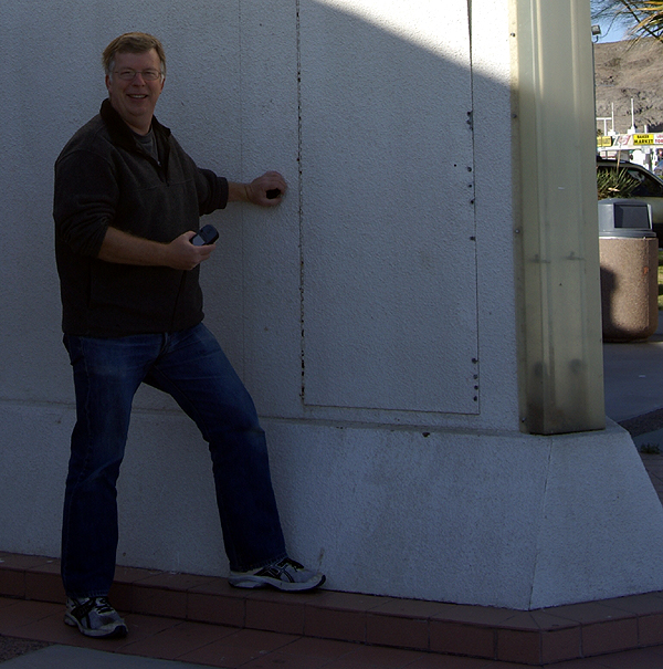
Pictures were taken at Some like it Hot - by AquaDyne

Monday, March 23, 2009
Another challenge?
I was looking at my DeLorme atlas yesterday. It is normally perched beside my computer. I actually have four atlases there, two AAA atlases and two DeLorme atlases. The two DeLormes cover all of California. I purchased them several years ago, quite possibly before I started geocaching. I use one of the AAA atlases for when I'm traveling and the other I use to scribble all over. Most of the scribbling is highlighting the roads that I've traveled on in my lifetime. It's an approximation, because 
I've been having some Internet problems and I finally got fed up with them on Saturday and pretty much solved the problem by upgrading my modem for my DSL line. Installing this, I had to pull out parts of the computer desk and one of the things that had to be moved were the atlases. When I put them back, I looked at them, mainly because my daughter had used them two weeks ago when she was here with a couple of her friends. They'd used them as their primary map for Southern California when they went to visit Hollywood. I decided to look at it to see whether it would have been helpful to them or not. On that verdict, I'm not sure what the outcome would be, but they didn't get lost, so I guess it was useful.
As I looked over the Southern and Central section atlas, my mind started to wander to this particular geocaching challenge that I'd heard of, but hadn't really given much thought of attempting. I kept thinking to myself, that I really didn't need another challenge, but then I also kept thinking as I perused the pages, things like, "I've found one on that page, oh and also on that page!" So I started counting them up and came up with 57 pages where I've already found caches. According to the cache page, there's 110 pages where I'd have to find a cache, so I'm already half way there without even trying.
Of course, the pages where I don't have cache finds are the ones that are the most remote. Many are out in the desert to the east of me, or in the Sierra Nevada, or in the middle of farm country in the central valley of California. There are several pages that will require some extensive planning in order to find a cache. This challenge is definitely more of a challenge than the 58 county challenge is. With the county challenge, driving the roads through the counties will work, because there's always caches hidden alongside highways and byways. With the DeLorme challenge, there's not necessarily a road within the map boundary, which means hiking.
As I looked over the atlas, I realized this could be too much on my plate at one time. My original goal was to finish the California County Challenge. I don't want to give that up just to switch to a new challenge. What I think I'm going to do is to continue the county challenge, but keep the DeLorme challenge in the back of my mind. Other map pages will be found as I work my way around the state. I think it also gives me new incentives to explore other areas of the state that I haven't done before. Of course, as I begin working on the counties in Northern California, then the Northern California DeLorme challenge comes into play as well. Together, these three challenges together will create a nice diversion for me and keep me busy caching for many more years. I can deal with that.

Wednesday, March 18, 2009
Tucked Away Treasures
After dropping off the two travel bugs near Disneyland, the Tadpole and I headed south into Santa Ana. We had two reasons for heading that way, the first being a virtual flag just around the corner from one of the elementary schools I attended. Amazing as it may seem, we didn't move once after my parents purchased the house in south Santa 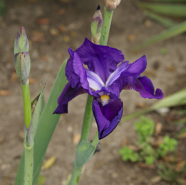
Unfortunately, I might not score any points for this flag. The GeoVexilla site has been down for almost a week. The map shows up on the main page, but no flags do. One of the other game players kept a daily database of all the flags and sent me a spreadsheet of all the flags that were within 100km of my home coordinates, so I was able to score that USA flag and the flag of Cyprus just north of Anaheim and Disneyland. If the site doesn't come back soon, I might not score the points, but that's OK. It was the adventure that counted anyway.
After scoring the USA flag, we headed east, just beyond my 6th grade school. There was a geocache about a half mile away that had looked intriguing when I'd scouted it out last week. Sarah May Downie had been placed in a small little park located at a rather odd intersection. The oddness of the intersection, five streets all coming together, made for some interesting pieces of land. The park was on a small triangular shaped piece of land between two of the streets that converged on this intersection, too small for a house, but the perfect size for a small memorial garden type of park. It was one of those tucked away treasures that all of us have stumbled across from time to time.
The cache page said the cache was hidden in a herb garden. I'm not sure about the herbs, but there was a variety of plant life. There were several bottle brush bushes that had grown fairly tall. I could hear two
There were lots of dime sized daisy type flowers, scattered in the raised stone beds along with some lantana which is very drought tolerant. They tend to have very small purple or orange flowers on them. In the picture, you can see some of the purple lantana near the white daisy. We found the cache, well hidden in one of the raised beds, very well cammoed. I seriously doubt this particular cache will be muggled. It was well done and it gave cachers a reason for being there looking for the cache and allowing cachers ample opportunity to look natural in the park, without having to resort to crawling in bushes to try and find a smallish container. That's always a plus when you're a middle aged man like myself and caching alone. Having the Tadpole along is much easier in the long run, but I appreciate caches like this anyway.
Just to the north of the park, was an old bridge that crossed Santiago Creek. We decided to walk over to the bridge in the hopes of perhaps finding a benchmark, but once we got over there, I realized there wouldn't be any, at least of an older variety. I can remember that Santiago Creek was a major barrier in many areas of Santa Ana with only major thoroughfares crossing the small stream crossing. During rainy times however, the dry stream bed usually became a torrent. There had been an older bridge 
We could see the old piers for the bridge on the north side of the new bridge, which had been fashioned to look like a 1940s style bridge. It was very well done and tricked me into believing that it was much older than it really was. Once we got up close, I could tell the bridge was less than 10 years old. The concrete was very smooth and new looking. We didn't find any benchmarks (I checked later on the site and no benchmarks were within a couple of miles of the bridge), but we enjoyed exploring it and the Tadpole seemed to enjoy the local history lesson I was able to give about the area when I was growing up. It was another enjoyable father/son kind of day.
Pictures were taken at or near the following geocache:
Sarah May Downie - by Rick&Liz

Saturday, March 14, 2009
We're going to Disneyland!
In January, I found a travel bug (Pluto's Dog Tag) that started in Washington and wanted to visit the different Disney Theme parks. 
Today, we were able to accomplish the goals for these two bugs. Tadpole held the coin and the bug up while I did the honors of taking the pictures of them in front of the park sign. There's a nice drop off spot where you can park for fifteen minutes to drop off people on the east side of the park which we took advantage of in order to take our two pictures.
After we took the pictures, I took us south to try and find a couple of geocaches that were large enough and close enough to the park. We got lucky there was a small Altoids tin type of container cache about a mile south of Disneyland where we were able to drop the geocoin. 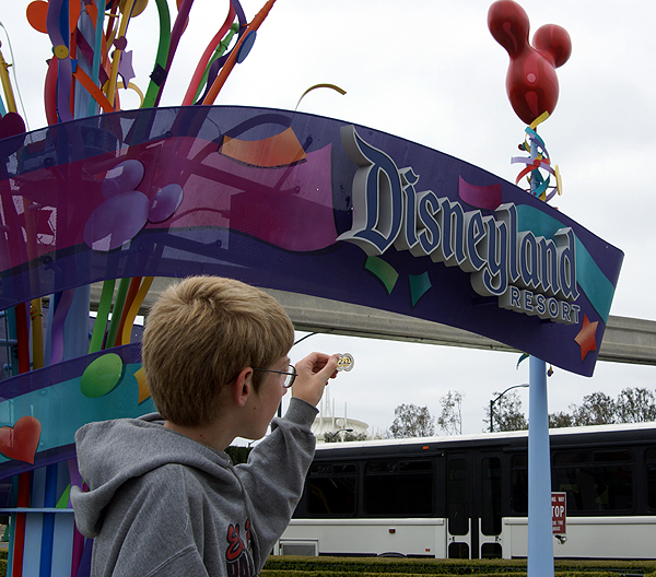
It was located near a medical center parking lot, which was virtually empty today since it was Saturday. We made the grab, trading a Boy Scout travel bug for Pluto. Hopefully, both of these travelers will enjoy the insides of many more geocaches.
Pictures were taken near the following geocaches:
Downtown Disney Virtual (NO Admission Required!) - by TeddyBearMama & Klemmer
WD's Original - by sbell111

Thursday, March 12, 2009
Email Burp
My email burped tonight. I've been having some Internet connection problems on and off for the past week or so and tonight it went out for the first time in about a week or so. And of course, it happened right in the middle of something 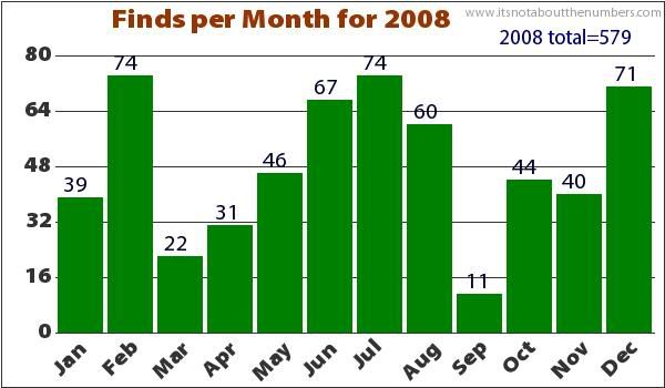
One interesting email was a cache that the Tadpole and I found down in Irvine in September. It wasn't anything special and it's already been muggled which is surprising because it was hidden away from most prying eyes, so it's surprising that it's gone. But, it represents about 9% of all of my cache finds for that month. As noted previously, September is always a slow month and this one was particularly slow for caching. I just found it interesting to go back and read my log for that cache. I'm also wondering what else gets upchucked to me.


