In a quick post last Saturday, I wrote about a gigantic smiley in the desert and that we were going to attempt to find all of caches in the series. 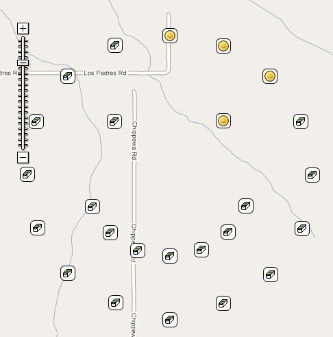 I would have written about this last night, except I'm having Internet issues and wasn't able to get them all logged until this morning. Twenty six caches later, I now have a map with a smiley on it. In fact, it's a very big smiley.
We left our house near 8 o'clock in the morning for the drive up to Victorville in the high desert. We had a couple of side trips to grab a couple of virtual flags that were out there and once we nearly got those taken care of it was time for lunch. After lunch and a couple more caches and one more flag, we decided to head on over and tackle the smiley series.
At first we weren't sure how we were going to progress on this trip. We found a nice dirt road in that went up and over a small hill. At the top of the hill was a nice pullout for cars, so we stopped there. Well, the other reason that we stopped was a cache not 56 feet north of where I'd parked the car. It was the first of the caches in the series.
The caches were all hidden in similar fashion using material that had been found out in the desert, so the hides were fairly easy. We just had to make a decision after the first one and that was how to proceed. Not having four wheel drive made the decision a little easier. We decided to hike the series. It had been advertised at a 1 mile in diameter circle, meaning the circumference of the circle would be 3.14 miles. Well, it wasn't quite like that, because there was another semi-circle making up the smile and also the two eyes.
At the first cache, we also noted that someone else had been out doing the series either at the same time or earlier in the day. We saw Clayton and Karen in every log book, but we never did catch up with them Saturday. After our second find around the outer circle, we cut in to the right eyeball, since we were at the closest point to it. 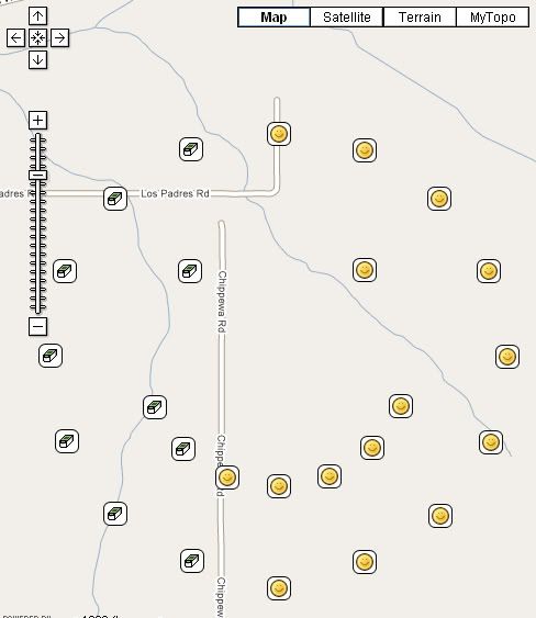 We saw a blue car driving north out of the smiley and we surmised that it could have been Clayton and Karen, but we weren't able to get their attention. Most of the scrub in the desert, at least at this point, is close to five feet tall and so it would be very difficult to spot anyone out there, especially if you weren't looking for them, which I have to assume they weren't.
I've been able to cache a couple of other series like there, where all the caches had a them to them. One series really sticks out in my mind because every cache container was exactly the same and it was hidden the exact same way. The only difference was a slight deviation in the name. We had to take meticulous notes on that series so we didn't make a mistake later on when logging the caches. This one had similar elements, but there was enough variation, especially the names of the caches, that it didn't become a problem.
The first section of the series was rather uneventful. When we got down to the south east part of the face, we started doing zig zags back and forth between the chin and the smile so we could get as many of the caches in the least amount of distance. At one of these zig zags, I spotted a small burrowing owl flying just over the tops of the mesquite. It landed near a mound that I assume was its burrow, but didn't want any part of us even though we were quite a ways away. As soon as it thought that we were moving closer to it, it took off again.
Midway through the smile, things began to get interesting. We found a cache, and discovered another set of names after Clayton and Karen's, that of Gumby and Pokey. This was a little perplexing since we hadn't seen their names in previous logbooks, yet here they were now showing up about halfway through the series. As we continued the hike, we realized they must have started the opposite way and traversed the smile in a counter clockwise direction while we were doing the same thing in a clockwise direction. We had to have missed each other while we were zigging and zagging between the smile and the chin.
Interestingly, Gumby and Pokey are old time cachers like me. They joined Geocaching in February 2001 about a month before I found out about it. I've found several of their caches in my neck of the woods and they've 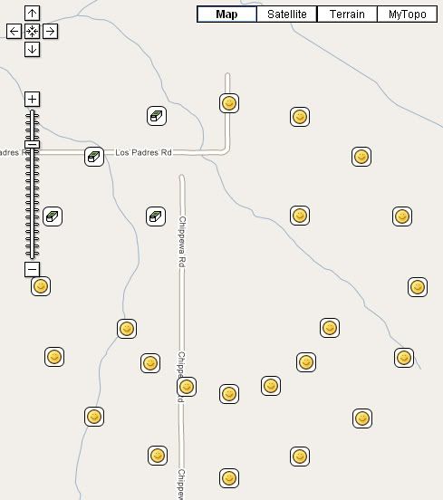 found at least one of mine. Their Lost Cache of Lytle Creek, has made my top five percent list as a wonderful example of what caching used to be before micro mania took over the hobby. But that's another subject all together.
There was also a mystery/puzzle cache attached to this series of caches. Clues to the whereabouts of this cache were to be found in the other caches around the smiley. Halfway through and we'd pretty much figured out where the mystery, or final as we came to call it, was going to be. We still needed some more information and we eventually found it in the other caches.
Looking at the maps, this must have taken some time to put together. It's not a wonder that it was a team of cachers, Dog Will Hunt, bigdaddygrc, Mr. G., and Rhino Assault Team that put it together. It's pretty simple math to decide where to place all of them (each cache was 22½ degrees around the circle), but finding the right spot and doing all the logistics would have taken a long time for just one cacher. Three cachers probably spread out the work load.
The sun was setting and we were nearing the end of the journey. We'd found the last piece to the final cache, so we decided to to get that before getting the last of the outer rim. This saved us about a quarter mile in walking, not much when you really think about it, but we were tired and that last mile just seems to take a toll on you. The final was an ammo can with lots of goodies in it. I decided to take a diabetes travel bug. Chaosmanor placed a couple of travel bugs and a geocoin to cover what I'd taken. Now it was off to the last cache on the outer rim and then a short 2 tenths of a mile hike back to the car and home. The final can be seen on the last map as the smile next to the Interstate 15 freeway. It's obviously not there and you can probably figure out where it really is hidden.
We had to hike up over a small rise to get to the last cache and from up there we could see out car in the dwindling daylight. I could see two people near the cache just next to the car and I put two and two together and figured that it had to be Gumby and Pokey. No one in our party can whistle loudly, so I shouted, but the desert air apparently stifled my cry. However, I could see that as we were approaching the final cache, they too were heading in the same direction.
We got over to that cache and waited for them. As they approached, I heard Pokey shout out, "Webfoot?" So immediately, I shouted out, "Gumby and Pokey!!" I've always found meetings between geocachers on the trail to be enjoyable and this one was no exception to that. It was fun to put faces to names that I'd seen ever since I started caching. Eight 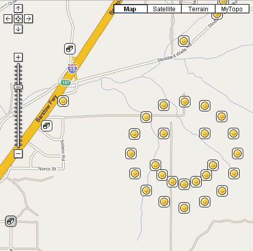 years of caching and we'd never bumped into each other before. Hopefully it won't be that long before we bump into each other again.
After signing the log for that last cache, we said out goodbyes. They still had to find the final and it was getting dark and we needed to be on our way as well. I put the final on my 5% list mainly because it represents the entire series of caches and was the best of the bunch. My one regret was not taking my camera. I'd opted to go light on this trip mainly because I knew it was going to be a long hike and it would have been tiring to carry it around all afternoon. Still, a picture of Gumby and Pokey would have been nice. I'm still trying to figure out why that blue bra was wrapped around a Joshua Tree out there near one of the caches. Bet that made you smile.
Monday, March 2, 2009
Smile and the World Smiles with You

![]()
![]()
Subscribe to:
Post Comments (Atom)
4 comments:
Check out also the CLUE series (Recently expanded to be the "NO CLUE" series)
http://www.geocaching.com/map/default.aspx?lat=34.67783&lng=-117.79708&zm=12&mt=m
Talk about a walk down memory lane...My dad and I spent many a weekend in that area when I was growing up. We used to take that second Stoddard Wells Rd exit and head toward Bell Mountain. Is there still a Denny's at the first Stoddard Wells Rd exit? We used to hit that on the way home for a cold glass of iced tea in the summer.
Great location for a series.
Okay, this? Totally cool. Thanks, Webby, for a great writeup on what looks to be an excellent series. Always look forward to reading your posts.
Just John,
I'm not sure about the Denny's out there. We accidentally got off on that exit, then quickly got back on the freeway to head further north to the second Stoddard Wells exit.
We were in the shadow of Bell Mountain for most of the afternoon. Well, not really the shadow since the sun was on the wrong side for us to be in the shadow, but it dominated the skyline to the west of us out there.
Post a Comment