Every time I go caching, I log the caches on-line. Then I update my spreadsheet and then the mapping file so I can update the map that I keep on my profile. This past weekend, I suggested to the Tadpole that I could create a map for him. He was enthusiastic 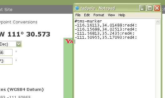 about this and I decided that it would be now or never.
I also wanted to see how many counties he actually had on his "official" finds list. He's recently become interested in finding the 58 county challenge cache. His "official" county count is small, only nine counties because he refuses to count any cache that he found with me before he started his own geocaching account. That's fine, except that we have some work to do for him to catch up to my county find total so we can get this cache together.
While I was making his map, I thought it might be a good idea to share the know how so that others, if they wish, could create a map of their finds. I've started to write something like this several times in the past, only to be stymied by the technical aspects of this, so I'm probably going to break this up into separate parts.
The first part of making a Tiger map is to create a text file of all the data points you want to include on the map. In this case, I had slightly over 300 data points from all of the Tadpole's cache finds. I've found that Notepad seems to work best when creating a .txt file, so I just opened up a new one of those and began inputting the data. In this case, the map file needs to start out with the header, #tms-marker as shown above in the picture. Then it's just a simple task of adding all the data points.
All the geographical data points have to be in decimal format. Since the cache pages all list the coordinates of the cache in degrees and minutes format, you'll need to find the decimal equivalent. So where do you get the decimal translation from a geocache page? 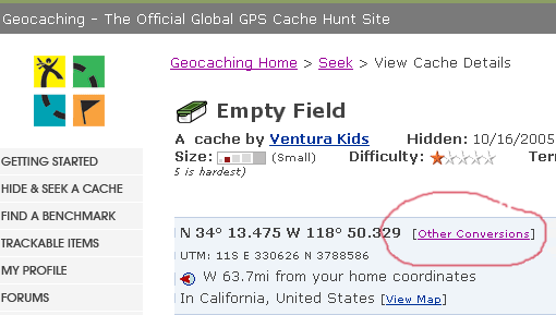 Click on the link on the cache page labeled Other Conversions. Then use the WGS84 Datum decimal coordinates for the cache and input those into your text file just like the example posted above. The decimal coordinates (East/West & North/South) are separated by a comma, but not spaces. At the end of the two decimal coordinates, type a colon. In my example I also have a red4 followed by a colon. This reduces the size of the red dot on the map.
Expect to spend some time entering all the coordinates into the text file. I took a couple of hours to input all of the Tadpole's cache coordinates into his text file, but that time is a one time deal. If you keep up to date after the initial inputting, it doesn't take much time at all to maintain the file. I'll explain how to create the parameters for the map in my next post.
Wednesday, April 29, 2009
Creating a caching map

![]()
![]()
Subscribe to:
Post Comments (Atom)
2 comments:
With GSAK, you could do this without the data entry.
As a quick summary, you would mark the caches you want in GSAK, set a view with only coordinates, export in the CSV format, import into excel, add the ":red4" column quickly, join the right two columns, aad export back out again in CSV.
Of course, GSAK isn't free. But it also has handy macros to easily make county maps all by itself with a few clicks without any of this trouble.. worth the cost IMO!
I need to investigate this. It would be easy to run a Found Cache PQ for this and run your steps.
Post a Comment