Saturday, I went up to the mountains to pick up my daughter. Obviously, since this is more about the desert than the mountains, I took a pretty circuitous route to get to the mountains. In fact, it was a rather longish route, but very fun.
I've been watching a couple of the virtual flags out in the desert and noting that several of them were about to expire, so I decided that Saturday morning would make a good trip out to get them. I created a bookmark list of caches along my intended route as well, so 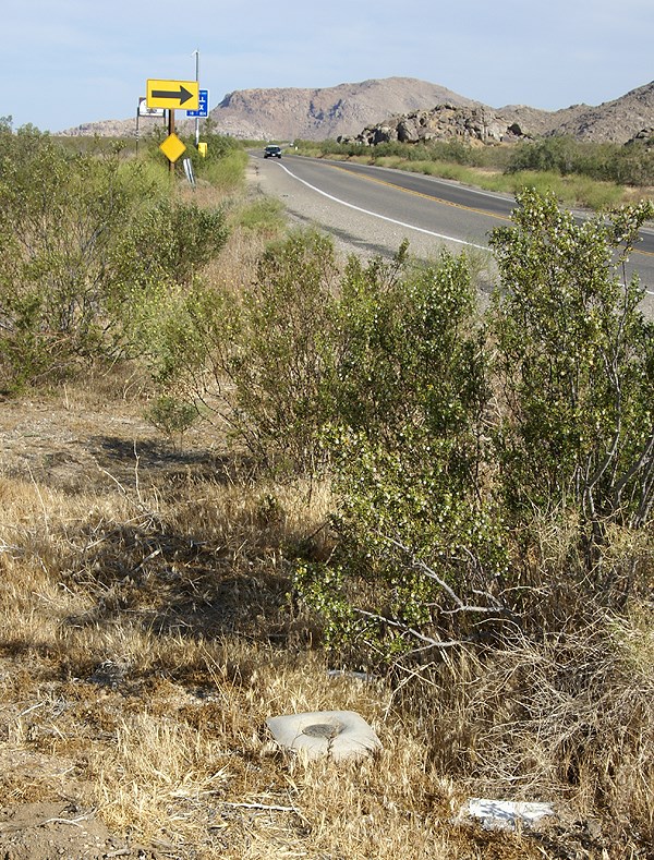 I could do some geocaching in between picking up the virtual flags.
My route took my up the Interstate 15 into Victorville, then east toward Apple Valley. There I was able to score a Bhutan flag. I also found a small cache behind a movie theater. Then I proceeded east along a road the Tadpole and I had traveled in the past. My goal was to head to the northern border of Joshua Tree National Park, mainly because there was a cluster of 3 virtual flags out there, plus one nearby.
As I was traveling, I kept noticing some of the caches that had been part of my PQ show up on the screen. There didn't seem to be adequate stopping areas for many of the caches, or either I was driving too quickly to make good stops, but I was able to make one stop at a cache entitled, POINT. Team Christiansen has created a bookmark of caches in the Apple Valley that are placed near benchmarks. With 32 caches on the list, someone who is interested in benchmarks would be able to spend a rather enjoyable day out there finding caches and logging benchmarks.
After parking near POINT, I got out of my car and immediately spied the nearby benchmark. No, not just one did I spy, but three benchmarks. This was almost as good as the other cache where the Tadpole and I found five benchmarks in one spot. After finding the cache, I went over to document the benchmarks. There were three benchmarks aligned in a row just off the highway. After taking the requisite pictures of each, plus a picture of each so people could get perspective on how they looked in the environment, I checked the cache page and realized that I'd missed one. A quick survey and I was able to spot the 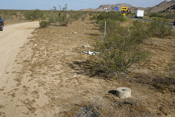 other one, located in a line perpendicular to the center mark.
I was able to log three of the four marks. One of the marks in the line of three was a newer benchmark from 1983 and wasn't in the benchmark system at geocaching.com. The other three, arrayed in a triangle shape all dated to 1934, the year after my parents were born. I'm at a loss at this time as to why the National Geodetic Survey wouldn't have that last mark in the database yet. Yet, I encountered another benchmark once I got over to the other virtual flags that wasn't in the system either.
This benchmark, which I found 38 feet away from a hidden cache, was a pipe cap type of benchmark, driven into the ground right on the boundary of Joshua Tree National Park. The mark is dated from 1932, so it's relatively old and I was hoping that it might be in the system, yet when I checked later on, it was not to be found. 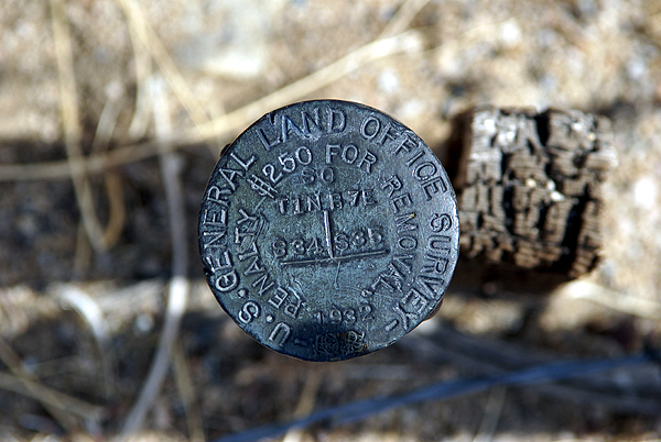 Even more curious, was other benchmarks, exactly like this one, were in the system. It's kind of interesting how hit and miss they seemingly are at times.
I think I'll keep these photos in a safe place. Who knows? Perhaps in the future, I'll be able to pull them out of the archives and log them when the database gets updated. From past experience, I was pretty sure I'd logged all the ones in my local area, but now it appears as if new ones are showing up in the database. This would indicate that the database does get updated from time to time. Now I just need a way to remember that I have them.
Pictures were taken at or near the following geocaches:
POINT - by Team Christiansen
Architectural Digest - by Joshua Tree Bonnie & Clyde
Sunday, May 31, 2009
Desert disks

![]()
![]()
Subscribe to:
Post Comments (Atom)
3 comments:
I've enjoyed your recent blogs on benchmarks. This one raises a couple of points that deserve responses.
The USGS (USCGS in old days) has never actually made any attempt to adopt into its system all of the survey marks set by the hundreds of other surveying entities across the United States. I know that you realize this, Paul, but lots of people don't, so I figured I should start here.
USCGS = United States Coast and Geodetic Survey.
NGS = National Geodetic Survey.
USGS = United States Geological Survey.
It's worth taking a bit of time to clarify acronyms. Lots of people, including any number of geocachers who log BMs, think that NGS and USGS are the same thing; they aren't. The NGS is what the USCGS became, when that agency was folded into NOAA. The USGS surveys rock and mineral deposits, fault lines, etc, as well as charts earthquakes. It also has a sizable presence in oceanography. It has little directly to do with elevation or position surveying.
Anyway, that US Land Office mark isn't in the system for (probably) one of two reasons: the NGS already had a mark or marks nearby which it felt adequately covered the area, or the NGS could not get accurate elevation or position information on it. The NGS will not add a BM to its system unless it has data that it trusts, and is in the required format. All that 'NAD 83' and 'NAVD 88' and 'Geoid Height' and so on that is seen on an NGS datasheet is all needed for a mark to be entered into the system. Naturally, every old mark that the NGS has set over the past 150 years or so has been updated, but it has nowhere near the staff to go around and check on other agency's marks unless there is a real value to the NGS.
Deb Brown (the "liaison" between the NGS and the public) told me a couple of years ago that the agency stopped adding any marks to its database about 15 years beforehand. The last marks that I can find are a series that CalTrans set along a number of freeways in 1993. These were all set as part of a statewide project that dovetailed well into the NGS goal of determining the exact shape of the Earth. She said that she foresaw little chance that the NGS would ever add more marks to its database. One reason for this is that satellite-based technology is doing a better job of mapping and surveying than can be done on the ground. This does not reduce the need for ground-based Stations, but it does reduce the need to add more; the thousands of extant marks should serve fine for almost all local construction needs, as well as property line determinations. The fact that the NGS still has use for physical marks is why they gladly accept all *properly documented* Recoveries from geocachers, and others.
That Land Office mark is interesting in that you can see the township and range numbers on it. This Station shows where two Sections meet. These and similar (The US Forest Service has marks like this all over the country) are useful as property line markers, but often have no elevation information. And the old T&R lines, which date from the Homestead Act, are often wildly out of alignment with each other, particularly in mountainous territory. The men (and a few women) who did the surveying did so with outrageously simple equipment, in horrible conditions, and generally did an amazing job, but much of it has little practical use today.
Hope this has been as informative as it is bloated ;-)
Phoo! You can see that lots of people get NGS and USGS mixed-up. I did it myself :-( That should be "NGS", not "USGS", at the start of paragraph #2.
The US Land Office mark that isn't in the system, as you noted, was probably not in the system due to your first point - "the NGS already had a mark or marks nearby which it felt adequately covered the area"
There are at least two US Land Office marks within 2.8 miles of the one that I noted that are in the system. One is 1.4 miles northwest approximately, and the other is approximately 2.8 miles to the west.
Post a Comment