Once you have your data in a text file, either by using my method, or by using reader Benh57's method, you'll need to upload it to a server. Most ISPs allow individual webspace and there's plenty of free spots out in the world wide web for you to do this. Once that is done, you just need to set your parameters for the kind of map you want.
I don't have know all of the parameters that can be used, so I'll interpret what's listed above for what I have on my particular map. All of the other parameters can be found here.
One of the things that I wanted to do was have a map that concentrated on the areas where most of my caching would take place, so I wanted to have the map centered in such a way that Southern California 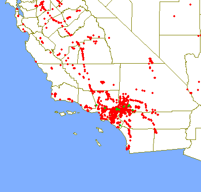 would be near the center, but not quite since I knew I would eventually be caching further north and east. By trial and error, I centered the map at 36.6° north latitude and 114.9° west longitude, which puts the center of the map in Nevada, about two miles east of this cache. The map to the left is a smaller version of the entire map.
The next two numbers specify in decimal degrees, how tall and how wide the map will be. In this case, the map will be 14 degrees by 11 degrees. By changing this you can cover larger or smaller areas of the globe. By making the numbers smaller, you'll obviously zoom in on a given area, which is what I did to show you the smiley out in the Mojave desert that we created when we found the Smiley series of caches.
The last two numbers creates the size of the map that will show on your screen. The default is 256 by 512 pixels which was a little too small for my tastes, so I upped it to 600 by 800. Once I get a bigger monitor or a new computer, I may up those so the map will fit on my screen again. The last thing I wanted for my map was to have the county boundaries show up, so I added the "on=counties" parameter. You can add railroads, streams and major highways to your map, depending upon what you want to display on your map. The choices are totally yours.
The last piece to the map is to add the url of your text file wherever it is stored. My caching map can be viewed here. The Tadpole's map showing his cache finds can be viewed here. The one thing to remember is the entire URL for the map, including all of the parameters is limited to 256 characters. Play around with it a little bit and you'll soon have a map to your liking.
Friday, May 1, 2009
Cache maps Part II

![]()
![]()
Subscribe to:
Post Comments (Atom)
No comments:
Post a Comment